Guest Post by Willis Eschenbach
(Note: In 2025 I revisited this issue in a post here. Same conclusion.
mung
/mənj/ [pronounced “munge”]
verb
INFORMAL•COMPUTING
gerund or present participle: munging
to manipulate (data)
EXAMPLE: “you could do what anti-spammers have done for years and mung the URLs”
For more than a decade now, I’ve been wondering about a couple of questions.
First, why does the satellite-based sea-level data show that the sea level is rising so much faster than the rise measured at tidal stations on the coastlines around the world? Records from tidal stations show a rise on the order of a couple of mm per year, a rate which is little changed over the century or so for which we have adequate records. But the satellite record (Figure 1) shows a rise of 3.3 mm/year. Why the large difference?
Second, why does the satellite-based sea-level show such significant acceleration? As mentioned above, the sea-level records from tidal stations, which are much longer, show little or no acceleration. But the satellite record claims that the rate of sea-level rise is increasing by about a tenth of a millimeter per year. That amount of acceleration would double the rate of sea-level rise in about thirty years. Again, why the large difference?
To start with, here’s what the satellite data says, according to the University of Colorado Sea Level Research Group.

Figure 1. University of Colorado sea level data, showing the trend and acceleration. Note that the graph shows no overlap between the individual satellite records. SOURCE: UCSLR Group
I got to thinking about these questions again this week, so I went to NOAA and got their Excel spreadsheet showing the full dataset for each of the four satellites.
I plotted up the NOAA data. But unlike the Colorado data above, I included the full overlap between the individual satellites. I then looked at the rate of sea-level rise shown by each of the four satellites separately. Figure 2 shows that result.

Figure 2. NOAA sea level data, showing the trend of each of the full individual satellite records and the overall trend. SOURCE: NOAA Excel Spreadsheet
Well, go figure … seems like after all these many years of wondering, I finally have an answer to my two questions. The trend is so large and the acceleration is so great for a simple reason. The two most recent satellites show trends that are significantly larger than the earlier two satellites. The first two satellites agree quite well, but they both show a much smaller trend than the latter two satellites. And neither half of the satellite record shows any acceleration.
Now I freely admit, I’m just a guy with no scientific training at all. I took Physics 101, Chemistry 101, and one year of Calculus in college, and that’s it. But the beauty of science is that it’s all about the facts and the evidence, and not about the qualifications of the person presenting the facts. What you see above are the facts as given by NOAA, and I’ve linked to the source of those facts above. And it seems to me that those facts are more than sufficient to entirely discredit the satellite sea-level record.
So if you have an explanation for those facts, fine. But don’t bother busting me because you think I’m not qualified to present and discuss the facts. “The Captain”, my great-grandfather who was a Mississippi riverboat captain, used to say “If you have to hang your diploma on your living room wall, there was something wrong with your education”.
And to return to the issues at hand, why does the NOAA data show an overall trend which is 0.3 mm per year smaller than the Colorado data? It’s because the Colorado data contains what is called the “GIA”, and the NOAA data doesn’t.
“GIA” stands for the “glacial isostatic adjustment”. There’s a description of it on the Colorado site here. It relates to the changes in the earth’s overall shape due to the melting of the huge and immensely heavy ice sheets from the last glaciation.
According to that page, the GIA is “independently estimated from models at -0.3 mm/yr (Peltier, 2001, 2002, 2009; Peltier & Luthcke, 2009)”.
Now, I’ve been programming computers since 1963, coming up on 60 years now. As a result, I’m very aware that a computer model is nothing more than a physical realization of the beliefs, understandings, and in particular the misunderstandings of the person programming the computer. Since Mr. Peltier has been intimately involved in programming all four of the model realizations listed on the Colorado site, their claim that the four models are “independent” is laughable. What we have is one man’s claim that he can calculate the GIA.
What effect does the GIA have? The Colorado site says (emphasis mine):
Prior to release 2011_rel1, we did not account for GIA in estimates of the global mean sea level rate, but this correction is now scientifically well-understood and is applied to GMSL estimates by nearly all research groups around the world. Including the GIA correction has the effect of increasing previous estimates of the global mean sea level rate by 0.3 mm/yr.
So there’s the missing 0.3 mm/year, applied by “nearly all research groups” … I guess NOAA didn’t get the memo.
For me, the claim that a computer model can calculate the changing of the total volumes of all of the world’s various ocean basins to the nearest 0.3 mm per year of sea level … well, let me just say that it strains credulity far beyond the breaking point and leave it at that. Here’s why.
For the land portion of the calculation, these “independent” computer models must be using GPS altitudes. By using split-phase GPS and repeated measurements, these can be as accurate as ± 10 mm or better, an amazing scientific feat … but that’s a far cry from a tenth of a millimetre, and that’s just on land. Not only that, but we don’t have GPS measurements all over the land. They’re concentrated in the US and Europe, with only spotty coverage elsewhere.
At sea, the “independent” models must be using satellite measurements, so we get into the question of the accuracy and precision of the satellite sea level measurements themselves. These measurements are done by bouncing radar waves off of the ocean surface and measuring how long it takes them to return to the satellite. Here, repeated measurements are not possible because the sea level at any point changes constantly, and the satellite is rarely in the same position twice. A recent NASA press release describing the Sentinel-6 satellite, the successor to the Jason-3 satellite, quotes the oceanographer Josh Willis:
Sentinel-6 will orbit about 800 miles up and use radar to measure the surface of the ocean. An instrument on the satellite sends a radar wave down to Earth. The radar bounces off the surface of the ocean and returns to the satellite. By measuring how long it took for the radar to go down and back — and accounting for moisture in the atmosphere which slows the radar down — scientists can measure how far away the surface of the ocean is from the satellite.
In other words, the satellite can tell scientists on Earth how high the oceans are, and how that height is changing over time.
“It’s really kind of an incredible feat of technology,” [Josh] Willis says. “We can accurately measure the water level with an accuracy of 1 inch from 800 miles up.”
An accuracy of 1 inch, that’s 25.4 mm … and they’re claiming they know the annual change in the volume of the oceans from the GIA to the nearest tenth of an mm of sea level height? I know that accuracy is different from precision, and that measurement of changes in length over time (precision) can be an order of magnitude better than the measurements of the length itself (accuracy), but still … sorry, but I’m not buying the GIA claim.
Let me see if I can give you a sense of the difficulty of the satellite measurements of sea level. The satellites orbit at an altitude of about 830 miles, which is about 1.34 billion millimetres. So to measure the change in sea level to the nearest tenth of an mm, we’d need to be able to measure the distance from the satellite to the sea surface to a precision greater than one part in thirteen billion … and that is a hard challenge even in a controlled laboratory setting.
Here are some of the difficulties in that measurement. First is the measurement of the altitude of the satellite itself. Unless we know that to the nearest mm or so for every second of every day, we’re going to get inaccurate answers. Next is the varying composition, temperature, cloudiness, and humidity of the atmosphere. All of these change the time it takes the radar signal to return to the satellite. Then there are the ocean waves, which obviously change the height of the ocean by thousands of mm. Finally, there is “instrument drift”, the inevitable changes that occur to electronic measuring instruments over time.
Net result? Well, the net result can be seen in Figure 2 above, where according to the University of Colorado one satellite says the sea level is rising at 2.5 mm/year, and a mere 8 days after the end of that satellite’s data (the interval between one satellite and the next in the Colorado sea-level record) the successor satellite says it is rising at 4.1 mm/year … no bueno. They’re claiming that in 8 days, the rate of rise jumped by 1.6 mm per year. Note also that there is absolutely no acceleration in either half of the satellite record, just a step-change between satellites. Clearly, they’re not able to measure annual sea-level changes to the nearest millimetre, much less to the nearest tenth of a millimetre.
However, the people working on the project are all true believers. In the same article, Josh Willis is quoted as saying “We know that the oceans are rising because of human-caused interference with the climate.”
Dang humans, always interfering with the climate … for example, our new “Climate Czar”, John Kerry, has 5 houses, a number of cars, a yacht, and a private jet, and he tells us to take the bus to avoid the dreaded “human-caused interference with the climate” … but I digress.
The problem is that starting out with a fixed “scientific” belief like that leads to the people working on the satellite sea-level datasets splicing together what are obviously incompatible satellite results, spreading peanut butter over the cracks so they can’t be seen, and announcing to the world that the satellites show a dangerous acceleration in sea-level rise, so we should all be very worried …
Me, I’ve said for some time that we shouldn’t put any weight on the satellite results. However, I have based this solely on the very large differences in both trend and acceleration between the satellite and the tidal station records, and the known difficulties in satellite measurements discussed above. I investigated this question in several posts, including “Inside The Acceleration Factory” and “Accelerating The Acceleration“
But now, at long last, I have the facts to back up my claim. There’s no evidence of any acceleration in the rate of sea-level rise in either the tide gauge or the shabbily-spliced satellite records. It’s been going up at on the order of eight inches (200 mm) per century for quite some time, and there’s no sign of any change in that rate of rise.
So you’re free to do what Obama and Bill Gates have done—buy seaside property. They proclaim loudly that the sea level is rising dangerously, but like the majority of climate alarmists, their actions belie their words.
My very best wishes to everyone in these most strange of times,
w.
PS—My usual request. To avoid misunderstandings, please quote the exact words you are discussing. I can defend my words, but I cannot defend your understanding of my words.
PPS—My post linked to above, “Accelerating The Acceleration“, earned me a laughable “fact-check” on Facebook by some well-meaning folks who were apparently short on cranial horsepower … now that Facebook has announced it’s taking over as the global arbiter of scientific truth, we’ll see what happens to this post.
“Now I freely admit, I’m just a guy with no scientific training at all. I took Physics 101, Chemistry 101, and one year of Calculus in college, and that’s it. But the beauty of science is that it’s all about the facts and the evidence, and not about the qualifications of the person presenting the facts.”
That makes you better qualified IMO than many who claim to be “Scientists”.
A scientist is by definition a person who uses the scientific method to discover facts or truth.
One of the earliest fathers of the scientific method was Ibn al-Haytham. He was the first to develop hypothesis by experimentation/observation. He wrote:
“The seeker after truth is not one who studies the writings of the ancients and, following his natural disposition, puts his trust in them,” the first scientist wrote, “but rather the one who suspects his faith in them and questions what he gathers from them, the one who submits to argument and demonstration and not the sayings of human beings whose nature is fraught with all kinds of imperfection and deficiency.”
IOW a scientist must be a skeptic that must develop/confirm his/her hypothesis by experimentation and observation and not base it on the supposed research of others alone.. If a person is not a skeptic then they aren’t a scientist no matter how many degrees or titles they may have.
The so called field of “climate science” is filled with people that rely on nothing more than computer models. Models that have without fail have been terribly inaccurate in their projections so far and yet they still treat them as valid scientific evidence. They are NOT scientists. They’re leaches working flawed academic and government systems for self enrichment.
The most dangerous phrase written by so called journalists today supposedly reporting on climate change is. “Scientists say”.
There is also the problem that one cannot find a number for the mm of sea level change per degree C change in atmospheric temperature. Just one of a dozen missing numbers that are fundamental to global warming hypotheses.
https://wattsupwiththat.com/2020/09/11/the-dirty-dozen-tests-of-global-warming-science/
Geoff S
Just out of curiosity how do they account or adjust for swell, waves, and tide ect. much of which depends on sun, wind, near by and direction of storms or weather fronts or condition. Just wandering.
P, see my guest post here a few years ago on Jason 3, if I recall correctly titled “Sea level rise from satellite altimetry—fit for purpose?” It was requested by Charles, and It went deeply into all the details you seek. See also my post on successor satellite Sentinel-6, which looked at the ‘improvement’ and concluded still not good enough. WE has this nailed.
Rud, your post is here, along with your great graphic explaining the difference between accuracy and precision, which I am definitely stealing.

Thanks,
w.
From Wikipedia referencing NASA information on Jason-3: The scientific goal is to produce global sea surface height measurements every 10 days to an accuracy of less than 4 cm. In order to calibrate the radar altimeter, a microwave radiometer measures signal delay caused by atmospheric vapors, ultimately correcting the altimeter’s accuracy to 3.3 cm.
So they measure the same spot once every 10 days, accurate to 3.3 cm. And they call that more accurate than tide gauges?
An orbit takes 112 minutes. Does anyone know how many data points they get per orbit?
There are 1436 minutes in a sidereal day. Divide by 112, and it appear that there are only 12.82 and a long string of small numbers of orbits in a day. The question is, how many orbits will it take to be a whole number of days? That is the next time when the satellite will be over the same point on the earth’s surface. Exceptions: if (a) the satellite is in exactly the equatorial plane, or (b) the satellite is at the level where it is permanently above some point on the equator. Obviously (b) is restricted to measuring the height above that one spot, which would give a fair estimate of sea level rise for that one spot. But over the years it would give a good estimate of the variability caused by wind, humidity, temperature, and any other atmospheric variables over that spot. Useful to calibrate the atmospheric variability for the other satellites!
Jason-3 took 9.9 days to get back over the exact same spot, so basically 1 measurement of 1 spot in the ocean every 10 days. Difficult to believe that there isn’t going to be huge variation, for starters.
The radar has a pulse rate that gives X number of “snapshots” per second which can be merged into a visual, but are individual data points. For Envisat, that pulse repetition frequency (PRF) was 1984 pulses per second. From those radar returns they calculated the sea level along the orbit track. Jason-3’s orbit was 112 minutes, so the speed of travel along that track was 40,000 km (circumference of Earth) / 112 minutes = 357 km/min. = 5.95 km/sec. = 5,950 m/sec. If Jason had the same PRF as Envisat, 1984 pulses per second, it would obtain measurements of sea level that were (5,950 m/s / 1984 pulses/s) = about every 3 meters apart, and 20,000 measurements as in the “example” above would take 10 seconds of orbit time and stretch 59.5 km. in a straight line. Doubtful to me that you can average any of it to get accuracy better than a couple of centimeters. That said, I don’t know if Jason has a faster pulse rate than Envisat. Still looking.
You also have a pointing error. The radar lobe is rather narow. A 0.1 degree pointing error gives 0.15 m too long measurement.
According to “Attitude Determination
and Control System” https://ntrs.nasa.gov, 0.1 degree is a high end requirement.
Some clarifications, which I hope help:
The precision of a measurement process is the degree of agreement among measurements. Precision is more or less synonymous with Standard Deviation. In theory the SD should shrink with increasing number of measurements. The opposite of precision is imprecision.
The accuracy of a measurement process is the degree of agreement of a set of measurements with the True Value of the quantity being measured. Accuracy cannot be determined if the True Value is unknown. Calibration (with known True Values) is the method used to improve the accuracy of a measurement process. The opposite of accuracy is bias.
Repeated measurements of an unknown value may have high precision but still be biased. Measurement errors (aka systemic errors) can lead to bias if the mean of many separate measurements differs significantly from the True Value.
The satellite data appear to have bias. Both sets may be precise (or not — the SD’s are not given nor are the number of repeated measurements at any one point), but they differ in means. Either a phenomena occurred in which sea level rise suddenly changed in 2010, or one or both sets are biased. The True Value remains unknown.
Willis, how come when I shoot, I only get 2 dots at most ? 😉
That graphic is a keeper. Thanks for reminding me of it.
I believe the original source for that graphic is here:
http://www.antarcticglaciers.org/glacial-geology/dating-glacial-sediments-2/precision-and-accuracy-glacial-geology/
I modified it slightly, to make the “low accuracy, low precision” example less accurate, and the “high accuracy, low precision” example a bit less precise, and also to add their requested attribution; click here to enlarge it:
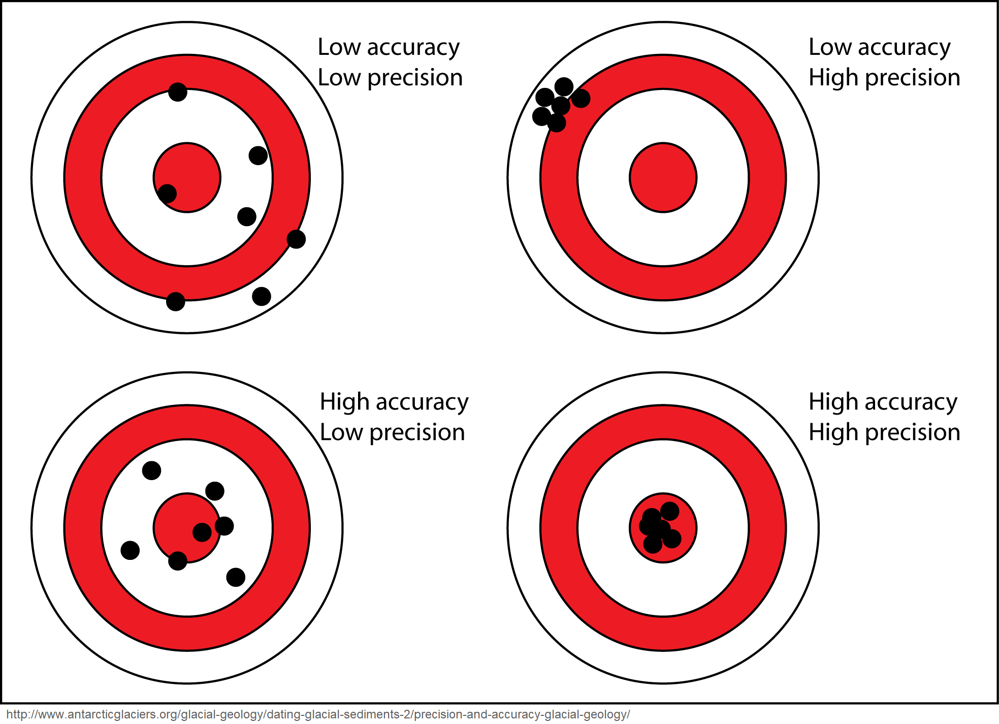
The problem is that if you remove the painted target, and are left with only the arrow holes (measurements), then you can’t tell the difference between the top row and the bottom row. When multiple measurements are highly consistent, that gives confidence in their precision, but if there’s systematic error in those measurements then their accuracy may still be poor.
OTOH, if your measurements are all over the place, that proves that they are of low precision, but they still might be of good accuracy. If you somehow know, a priori, that they are of high accuracy, and if you can take a large number of measurements, then you can reliably “find the bull’s eye” simply by averaging those measurements, even if few of the individual measurements were on target.
The problem is the temptation to simply assume that the measurements are of high accuracy, out of optimism, or because that makes it easier to justify your grants. That’s how you can end up reporting erroneous results.
Many, many things in climatology look like that. Measurement of sea-level by satellite altimetry is an obvious example, but there are many others.
For example, as reported in AR5, the CMIP5 climate models assume a wide range of values for even such fundamental parameters as radiative forcing from a doubling of CO2 (ERF), and climate sensitivity (TCR & ECS).
https://sealevel.info/AR5_Table_9.5_p.818.html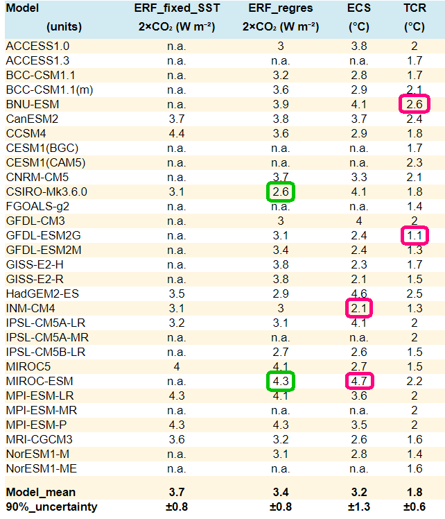
EXCERPT:
That proves that those parameters are known with poor precision. Yet alarmist climate modelers assume that by averaging the models’ outputs, they can nevertheless “find the bull’s eye.” That means they’re assuming high aggregate accuracy of models’ long-term (and thus effectively untestable) predictions, despite the known poor precision of the models’ internal parameters. There’s really no evidence to support such an assumption.
Thanks very much.
Willis – This brings back ancient memories. Years ago I worked on ICESat-1 with Scott Luthke. The GIA accuracy numbers aren’t looney and I do remember going through them 20 years ago, but I can’t remember the process now for the life of me. The bigger issue and the source of the arguments is the assumptions going into the GIA estimate. I’ll have to go consult the ancient records.
Too bad you can’t grep dead trees. Your search would be faster if you could.
Please do consult your ancient records. I’d be interested in how such high precision is rationalized.
Satellite could say sea level is rising by 1 meter a day, but if the tidal gauges don’t change, then who cares. The gauges give information relevant to the concerns. The satellites do not. IMHO, when the satellite data is cited, it is usually in the form of a FOC attack.
Fear instilled by graphs procured by
Obscure methods, cited by people with impressive
Credentials
Mr. Lee wrote, “The gauges give information relevant to the concerns. The satellites do not.”
True! It is not often mentioned in the climate alarmist community, but satellite altimetry is incapable of measuring sea-level at the coasts — which are the only places where it matters.
You might think that doesn’t matter, but it does, because some factors affect sea-level ONLY at the coasts (and not out at sea), and others affect sea-level ONLY far out at sea (and not at the coasts).
For instance, thermal expansion of the upper ocean causes “steric” sea-level rise where the water warms, but it does not affect sea-level elsewhere. That’s because gravity balances mass, not volume. That’s easiest to see for icebergs, but it’s true for anything which affects water density:
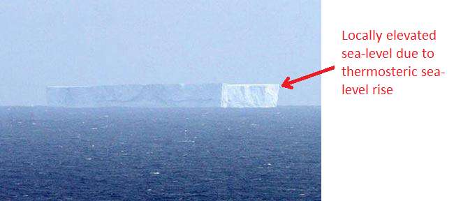
So, for example, an area of warm water in the Indian Ocean can cause sea-level rise detected by satellite altimetry, without ever affecting coastal sea-level, at all, anywhere. Variations in sea-level trend caused by that have no relevance to any practical concerns.
<b>Warning,</b> historical and pedantic note follows:
From the [nearly] authoritative source, The New Hacker’s Dictionary, comes http://www.catb.org/jargon/html/M/mung.html:
Of course, as old DEC (PDP) computer users should know, the MUNG command runs the text editor (and general purpose programming language) TECO, and has it read in and execute a TECO program to mung the file that needs to be munged.
See http://www.bitsavers.org/pdf/dec/teco/MobyMunger_%233part1_Aug79.pdf for more. I have dinner (now a Zoom meeting) with the author, Stan Rabinowitz, every month.
Thanks, Rick, most interesting. Meaning 2 is the way I always heard it, but I couldn’t find it in the dictionary.
w.
Does that mean mung bean sprouts are really GMO? Heavens to veganism! 🙂
“I’ve been programming computers since 1963”. COBOL? You’re like me a fossil remnant. As an engineer, I started with FORTRAN in ’63. Ahh…
But, now more to the point, as far as we humans are concerned, doesn’t the tide gauge data be the ONLY significant data? If we’re rising too?
Frankly there’s a large amount of hubris in much of these prognostications.
Previous should of had a Willis in front. My bad.
Willis, a minor quibble here. One part in 10E10 is not that difficult for a timing measurement, and with care that can be bettered by a couple of orders of magnitude. The other sources of error that you mentioned are cause for concern.
Thanks, Erik, but this is the reason that I ask folks to quote what they’re talking about. I have no idea what I said about a “timing measurement” that you are discussing.
Care to clarify?
w.
Willis,
“So to measure the change in sea level to the nearest tenth of an mm, we’d need to be able to measure the distance from the satellite to the sea surface to a precision greater than one part in thirteen billion … and that is a hard challenge even in a controlled laboratory setting.”
Mea culpa – you didn’t specifically mention timing. My recollection is that the earth moon distance has been measured to close to that level of relative precision using retroreflectors from the Apollo program. It does help that the retroreflectors are essentially stationary with respect to the moons surface, but the same thing cannot be said about the actual ocean surface with respect to the mean sea level.
just btw kerry does not own a yacht . he owns several yachts and numerous mere boats .
Willis, it’s a good thing you didn’t get more education. You might have ended up much dumber. As my father would say, “Educated FOOLS”. Appropriate for many of today’s so called scientists. Common sense will win.
“As my father would say, “Educated FOOLS”.”
I’ve come up with a neater version: “No fool like a wise fool.”
It won’t if the foolish people control the military.
Similar to how there was such a desperate need to be rid of Mr Trump, The Need for Sea Level Rise (SLR) is equally urgent.
Without SLR, the whole Global Changing Warming Warm house-of-cards collapses and for manifold reasons:
1) ‘Everybody‘ knows that warm things expand. Thus SLR = expanding ocean and all other things being equal, it has to ‘rise’
OK BUT, only El Sol can heat the water. Sol’s output is claimed to be by all parties so therefore doesn’t count.
Warmists then want their Cake & Eat It by asserting more water vapour (to actually create the GHGE) in the atmosphere – which can only cool the water because of greater cloud cover.
2) Radiation from CO2 cannot warm the water, CO2 simply doesn’t radiate at the temperatures involved. It has zero emissivity
3) What little radiation there is coming from the atmosphere ## cannot warm the water without perfectly munging the whole idea of Entropy. It requires Heat Energy to flow up a Thermal Gradient
## Take average Troposphere temp to be minus 15 Celsius, emissivity of Oxygen/Nitrogen to be 0.02, you get downwelling power of 5.02 Watts per square metre
4) Even if energy did get into the water, it would float on the top 100 metres and not cause a bulk expansion. By floating on the top, extra energy would very promptly dissipate exactly as happens inside El Nino. The energy would physically go up into the atmosphere and down the thermal gradient, even if just a few 10’s of metres, from where it can NEVER return, without violating the Law of Entropy.
5) Alert readers might wonder and should demand to know why the ocean expands when it gets warm whereas the atmosphere is not allowed to expand.
They will demand an answer as to why the atmosphere simply doesn’t expand to ‘disappear’ the Trapped Heat in that means instead of staying a fixed volume and getting hot.
Yet more perfectly good, rock-solid and long established Physics is required to be munged.
Good grief and especially for peeps SO CONCERNED about Temperature , the expansion of Ideal and near Ideal gases was/is the very basis of THE most accurate thermometers ever made.
Conclusion & Theory time:
You all know me, what SLR there is is coming from Soil Erosion, the creation of new desert, thus:
So you see (sea haha) SLR is The Sacred Cow that has to be kept alive at all costs.
The whole of Climate Science is riding upon her back and as we see from their science, their politics, their (anti) social media presence, no trick is too low or too dirty.
As Mr Trump discovered to his political (and personal?) cost
Well put, peta.. let me add a bit.
3) The only way you can measure CO2 radiation frequency bands is by creating conditions of negative temperature gradient, by using a strongly cooled receiving sensor.
At atmospheric pressure, the mean free path of any CO2 radiation is measured in 10’s of metres, so anything in that frequency band is only from less than 100 or metres away.
4) Evaporation caused by any radiation would actually cause the water surface to COOL slightly.
SLR is also due to our mining of fossil water.
Fort Denison will slip under the water any day now ..
…or maybe in several thousand year !!
Got to thinking about it, and realized that my main objection to Brian Jackson’s comments (other than the snarky tone) is that he hasn’t answered my main question.
This is, if averaging can increase the accuracy of the sea-level rise results to the required level as he claims, and if none of my objections to that claim are true, as he says over and over … then why does the trend make an instantaneous step change from 2.5 mm/year from the first two satellites, to 4.1 mm per year from the third satellite? I mean, if there are no issues as Brian claims, then why that huge anomaly?
w.
I did laugh when I said “What if one of the 12″ marks on your measuring stick is off by an inch”, and his response was “Seriously Willis, as a professed builder of his own home, you can’t tell me that a tape measure can’t make 1-foot markings?”… dang, bro’, avoid the point much?
They actually started “adjusting” past data when they changed from Topex to Jason 1
I guess they just found ways to keep doing it
Here is 2003 data overlaid over data from 2000, more than DOUBLING the trend !!!
About the same time all the manifestly FAKE “adjustments” in the temperature data started to happen.
OOPS….. 2000 data over-laid on 2003 data !!
Fred, what is the source of the two datasets?
w.
I had to look up the definition of “Pissing Contest” I was also reminded about the Uncle Remus tale about Brer Rabbit and the tar baby. Over at Roy Spencer’s blog there’s an ongoing argument about whether the Moon rotates or not. Well that’s my editorial comment.
Here’s a graph of the changes Colorado University made to their sea level data up to 2016:
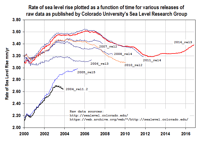
Each plotted point represents the rate of sea level rise since the start of the time series in late 1992. I can only conclude that over time the historical data has been rewritten.
The last two installments since 2016 have increased the acceleration from 0.084 to 0.097 mm/yr² I feel like the bank examiner trying to figure out where the money was embezzled.
Willis,
I just went back to check BJ’s claim, and he does claim that multiple measurements can improve the accuracy. I think it is he who does not understand the difference between accuracy and precision.
And these same people presume to tell our ancestors that they did not how to measure temperature and “correct” their readings.
Clearly moderns have not been able to workout how to climb to shoulders of giants!!
Acceleration explained as change in change.
https://tidesandcurrents.noaa.gov/sltrends/sltrends_station.shtml?plot=50yr&id=9414290
Looks like a 70-80 year oscillation. Its interesting that error ranges increase over time, with the ‘present’ being more uncertain than the ‘past.’
Willis, That is a great article, and the comments are illuminating too.
I am intrigued by the satellite calibration. The lakes that are used to verify the height of the satellite must be very special, No doubt guarded at all times to avoid any variation in their surface taking place.
They must also be static with no ground uplift or sinking taking place. They must be free from any wind heaping up water at the moment the satellite comes over to take its height fix.
The risk of unknown variation being introduced is endless even the beavers pushing his freshly chewed log might get in the way.
Even the back of all those turtles we rely on to keep us up might vary, who knows…:)
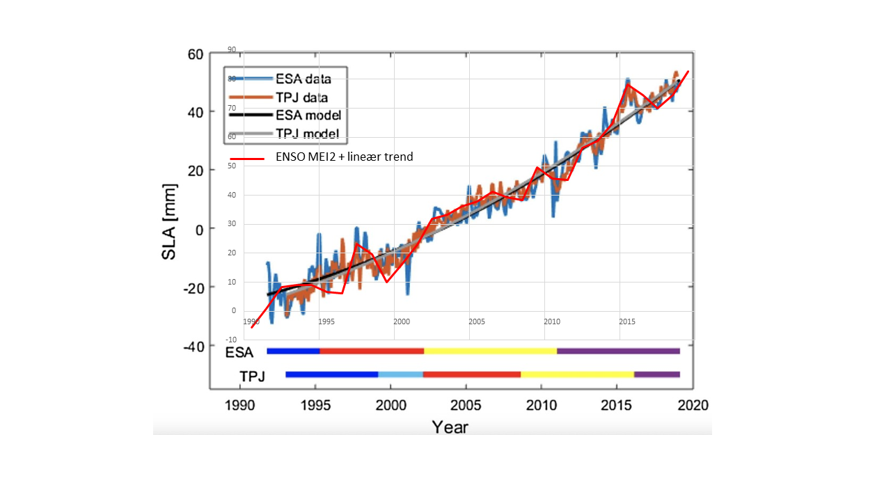
There is acceleration but it is caused by ENSO.
I think one of the problems with the chart is that it doesn’t show the error bars. With them any statement about a trend so small as to show acceleration would be meaningless.
Motto of climastrologists: We don’t need no stinkin’ error bars!
different parts of the world have different sea level rise – or fall,
it looks like the first two satellites were inspecting one part of the world and the other pair another place.
i refer to nils axel morner https://www.researchgate.net/publication/284392946_The_great_sea_level_humbug_No_alarming_sea_level_rise
To mung, we can add “ming”.
(No – not Ming the merciless.)
“Minger”
noun British Slang.an ugly, unpleasant, or smelly person or thing.
The munged-up sea level (and global temperature) record is a minger!
It mings!
Since it was munged.
The minging mungers have munged it into a minger!
The Dutch know this stuff very precisely. The tidal gauges on the North Sea show a sea level rise of 1.9mm/yr ever since systematic measures began (in the 1870s). The North Sea is in open connection with the Atlantic, which is in open connection with the Indian Ocean, which is etc. with the Pacific. There was a bloke in Syracuse 2 millennia ago who figured that that means that in all those waters the rise has been 1.9mm/yr, give or take a tiny correction because the geodetic surface is not an exact sphere.
If measures from satellites give a different answer then there is something fundamentally wrong with such measurements.
Sydney’s Fort Denison is on a highly stable geological area.
SLR is about 1mm/year, with no acceleration
Fort Denison is an almost exact match for the data from the Bondi Baths Stilling pool.
oops, got the colours mixed up..
Sorry, Fred, but that’s not true about Sydney being stable. There’s a very good analysis of Pacific tide gauges and GPS levels in a post called “Relative sea-level rise and land subsidence in Oceania from tide gauge and satellite GPS“. From the Abstract:
Recommended reading for anyone interested in the issue.
w.
Wonderful, thanks for the reference Willis. Interesting stuff.
The tide gauges I am familiar with are typically situated in somewhat protected waters having access to the sea. The water surface is thus much smoother than what would be found by satellite measure on the open ocean. How exactly does the satellite iron out all of the surface variation (wave, chop, ripple) caused by wind?
accelerators are also supposedly a group of troublemakers causing homeland security issues by starting violence IN usa rallies etc also then linked(supposedly) by cia or fbi to some twerp in russia
sheesh facepalm roflmao
Agreed that sea level measurements with satellites cannot possibly be accurate or precise to within 0.1 mm or less from a satellite orbiting 830 miles above the earth, measuring seas that constantly vary in height by meters over time and distance.
The other factor of course is that sea level rise is a function of multiple processes, not just ice melting or thermal expansion of the oceans. The earth’s crust is in constant motion, due to plate techtonics, which has to effect sea level. And erosion and dissolution of the land surface constantly adds material to the oceans. Tidal forces, or course, play a role, as do ocean currents and prevailing winds. Every geologist certainly understands that, if not the so-called “climate scientists”.
And there is no possible one single worldwide number that can be used to represent the net effect of crustal rebound after the last glaciation.
It is commonly known that land is rising in the north because the glaciers melted. What is out of sight, and therefore out of mind, is that if the volume of water in the oceans is increasing from melting glaciers and mining of ground water, then the extra weight, particularly in the deepest waters, will cause the upper mantle to respond by sinking deeper, thus increasing the volume of the ocean basins.
And then there is the issue of the mid-ocean spreading centers introducing new rock, which if it isn’t compensated by subduction, will result in a decrease in ocean volume.
It is a very complex problem, and without detailed maps of the shape of ocean basins, and measurements of rate of production and destruction of ocean floors, there is little hope of measuring Glacial Isostatic Adjustment to 0.1 mm.
The important issue is whether people will be inconvenienced by a transgressing shoreline. That appears to be more a factor of local subsidence than SLR.
I agree with you in general, Duane. In term of mankind’s concerns in the foreseeable future, however, tectonic movement and erosion are miniscule.
GPS satellite orbit ephemeris is accurate to about 5 cm, updated by range tracking amongst 8-12 remote tracking sites (Diego Garcia has one). This level of accuracy is required for the p(Y) code capable military GPS receiver applications (offensive and general navigation).
Air Force Satellite Control Network – Wikipedia
What isn’t so straightforward is adjusting the raw radar range data with “models” to compensate for:
To get sub-cm level accuracy is a bit of a stretch, actually.
“It’s been going up at on the order of eight inches (200 mm) per century for quite some time, and there’s no sign of any change in that rate of rise.”
Well it’s running uphill a lot somewhere else then-
“One of the oldest tide gauge benchmarks in the world is at Port Arthur in south-east Tasmania. When combined with historical tide gauge data (found in the London and Australian archives) and recent sea level observations, it shows that relative sea level has risen by 13.5 cm from 1841 to 2000.”
:: Sea-level Rise :: CSIRO & ACECRC ::
And when the CSIRO munge it the best they can come up with is-
“We have used a combination of historical tide-gauge data and satellite-altimeter data to estimate global averaged sea level change from 1880 to 2019. During this period, global-averaged sea level rose about 25 cm, with an average rate of rise of about 1.6 mm/yr over the 20th Century. The sea level record indicates a statistically significant increase in the rate of rise from 1880 to 2019.”
And I’m telling you this ancient weather worn continent of Gondwanaland aint moving anywhere in relation to the oceans surrounding it-
ANCIENT GIANT UNDERWATER REEF FOUND IN NORTH FLINDERS – Coober Pedy Regional Times (cooberpedytimes.com)
And it has generally warmed (naturally, from the LIA) from 1880 to 2019. The “acceleration” is undetectable.
The most sage advice I can give to these modern day sundry climastrologists and clairvoyants is simply this. If yer gunna paint the house use something a lot better than Covid masks while you’re sniffing the turps-
Adelaide’s Tidal Wave. The One That Never Happened | Adelaide Remember When