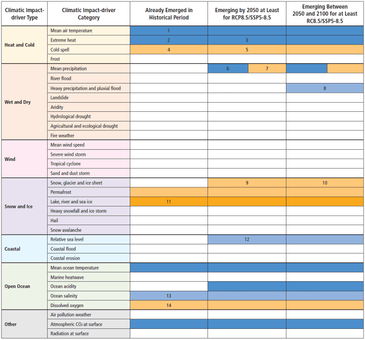
The following chart and definitions is from Chapter 12 of the UN IPCC Sixth Assessment Report, Page 90 of Chapter 12 Climate Change Information for Regional Impact and for Risk Assessment. It essentially charts the UN IPCC’s assessment of the odds that each type of extreme weather is due to climate change.
As can be seen from the chart, there is no evidence of any increase or decrease, globally or by region, in the frequency, severity or extent of frost, mean precipitation, river floods, heavy precipitation and pluvial floods, landslides, aridity, hydrological drought, agricultural or ecological drought, fire weather or wildfires, mean wind speed, severe wind storms or tornados, tropical cyclones or hurricanes, sand and dust storms, snow glacial or ice sheets, heavy snowfall and ice storms, hail, snow avalanche, relative sea levels, coastal floods, coastal erosion, marine heatwaves, ocean acidity, air pollution weather or radiation at earth’s surface.
Academics, scientist, the media or politicians who say otherwise are contradicted by the institution most identified with promoting catastrophic global warming, that is the United Nation’s Intergovernmental Panel on Climate Change, the IPCC.
The last and second to last columns in the chart below are model predictions of what will happen greater than 25 years from now and only based on the most extreme forecasts of CO2 emissions, that the IPCC and virtually all climate scientists now consider impossible levels of CO2 emissions.
Table 12.12 | on Page 90 – Chapter 12 of the UN IPCC Sixth Assessment Report. Emergence of Climate Impact Drivers (CIDs) in time periods, as assessed in this section. The color corresponds to the confidence of the region with the highest confidence: white colors indicate where evidence of a climate change signal is lacking or the signal is not present, leading to overall low confidence of an emerging signal. See the key at the bottom for the meaning of all colors.

- High confidence except over a few regions (CNA and NWS) where there is low agreement across observation datasets.
- High confidence in tropical regions where observations allow trend estimation and in most regions in the mid-latitudes, medium confidence elsewhere.
- High confidence in all land regions.
- Emergence in Australia, Africa and most of Northern South America where observations allow trend estimation.
- Emergence in other regions.
- Increase in most northern mid-latitudes, Siberia, Arctic regions by mid-century, others later in the century.
- Decrease in the Mediterranean area, Southern Africa, South-west Australia.
- Northern Europe, Northern Asia and East Asia under RCP8.5 and not in low-end scenarios.
- Europe, Eastern and Western North America (snow).
- Arctic (snow).
- Arctic sea ice only.
- Everywhere except WAN under RCP8.5.
- With varying area fraction depending on basin.
- Pacific and Southern oceans then many other regions by 2050.

You must be logged in to post a comment.