
Image Credit: Monterey Marine Meteorology Division – HYbrid Coordinate Ocean Model (HYCOM)
By WUWT regular “Just The Facts”
In making several updates to the WUWT Ocean Reference Page I observed something in the Sea Surface Temperature animation above, that I’ve seen a few times before. More about that below, but first the reason for the updates. The Naval Research Laboratory Navy Coastal Ocean Model (NCOM) was “scheduled to be retired on 5 April 2013 and replaced by operational 1/12° HYbrid Coordinate Ocean Model or HYCOM.” The “HYCOM consortium is a multi-institutional effort sponsored by the National Ocean Partnership Program (NOPP), as part of the U. S. Global Ocean Data Assimilation Experiment (GODAE), to develop and evaluate a data-assimilative hybrid isopycnal-sigma-pressure (generalized) coordinate ocean model (called HYbrid Coordinate Ocean Model or HYCOM).” Here is HYCOM’s home page of and here is the system background information on the “Real-time 1/12° Global HYCOM Nowcast/Forecast System”.
The new HYCOM Global Sea Surface Temperature 30 Day Animation Including 7 Day Forecast at the head of this article has been added to the WUWT Ocean Reference Page, along with the 1 Day graphics for Sea Surface Height and Sea Surface Salinity. In addition to the new Global imagery from HYCOM, there are also a wide array of regional images and animation available from HYCOM including various sections of the Atlantic, Indian, Pacific, and Polar Oceans. The HYCOM regional imagery and animations include not only Sea Surface Temperature, Sea Surface Height and Sea Surface Salinity, but also offer Speed/Currents images and animations, such as this Equatorial Pacific Speed/Currents 30 Day Animation Including 7 Day Forecast:

In terms of the observation that gave me a sense of Déjà vu, if you look at this Equatorial Pacific Sea Surface Temperature – 30 Day Animation Including 7 Day Forecast;

you’ll see a tongue of cold water begin to extend across the Equatorial Pacific. The last time I saw a similar feature was August of last year;

i.e. the last time ENSO (El Niño/La Niña Southern Oscillation) swung towards a neutral/colder phase:

It also reminds me of when Phil Salmon argued in his article Is the ENSO a nonlinear oscillator of the Belousov-Zhabotinsky reaction type? here on WUWT, that ENSO may be a Non-Equilibrium Pattern System, i.e.:
“Of the class of known attractors of nonlinear oscillatory systems, the Lorenz and possibly Roessler attractors bear similarities to the attractor likely responsible for the alternating phases of La Nina and el Nino dominance that characterise the ENSO and constitute the PDO.”
A Non-Equilibrium Pattern System, aka “nonlinear pattern formation in far-from-equilibrium dissipative system” and “pattern formation in dissipative system” refers to;
“the spontaneous formation of spatio-temporal patterns” that “can occur when a stationary state far from thermodynamic equilibrium is maintained through the dissipation of energy that is continuously fed into the system. While for closed systems the second law of thermodynamics requires relaxation to a state of maximal entropy, open systems are able to interchange matter and energy with their environment. By taking up energy of higher value (low entropy) and delivering energy of lower value (high entropy) they are able to export entropy, and thus to spontaneously develop structures characterized by a higher degree of order than present in the environment.” PhD thesis – “Controlling turbulence and pattern formation in chemical reaction” by Matthias Bertram
Here are a couple videos of Non-equilibrium Pattern Systems these being examples of Belousov-Zhabotinsky (BZ) reactions:
and for comparison here is another animation and visualization of Equatorial Pacific Ocean Temperatures. Furthermore, another interesting observation from the WUWT Ocean Reference Page are the BoM Monthly Subsurface Pacific Ocean Equatorial Temperature Anomalies down to 400 Meters;

which show that cold water has recently begun to well up from depth in the Equatorial Pacific. For reference:
In a “normal,” or ENSO-neutral year, a low atmospheric pressure center forms over northern Australia and Indonesia and a high pressure center forms on the other side of the Pacific over Peru. At the same time, the trade winds blow steadily east to west along both sides of the equator to move warm surface waters from the eastern to the western Pacific and cause cold, nutrient-rich bottom water to well up off the coast of South America. Woods Hole Oceanographic Institution
El Niño is the name given to the occasional development of warm ocean surface waters along the coast of Ecuador and Peru. When this warming occurs the usual upwelling of cold, nutrient rich deep ocean water is significantly reduced. El Niño normally occurs around Christmas and usually lasts for a few weeks to a few months. Sometimes an extremely warm event can develop that lasts for much longer time periods. In the 1990s, strong El Niños developed in 1991 and lasted until 1995, and from fall 1997 to spring 1998.
The formation of an El Niño is linked with the cycling of a Pacific Ocean circulation pattern known as the southern oscillation. In a normal year, a surface low pressure develops in the region of northern Australia and Indonesia and a high pressure system over the coast of Peru (see Figure 7z-1 below). As a result, the trade winds over the Pacific Ocean move strongly from east to west. The easterly flow of the trade winds carries warm surface waters westward, bringing convective storms to Indonesia and coastal Australia. Along the coast of Peru, cold bottom water wells up to the surface to replace the warm water that is pulled to the west. PhysicalGeography.net
This is not to say with certainty that ENSO (El Niño/La Niña Southern Oscillation) is in fact a Non-Equilibrium Pattern System, nor that ENSO has begun to swing towards a neutral or cold phase, rather these are just observations of interesting patterns within the Equatorial Pacific.
In addition to the WUWT Ocean Reference Page if you have not had the opportunity to look through some of our other Reference Pages, it is highly recommended:
- Atmosphere Page
- Atmospheric Oscillation Page
- ENSO (El Niño/La Niña Southern Oscillation) Page
- “Extreme Weather” Page
- Geomagnetism Page
- Global Climatic History Page
- Global Temperature Page
- Ocean Page
- Oceanic Oscillation Page
- Polar Vortex Page
- Potential Climatic Variables Page
- Scafetta’s Solar-Lunar Cycle Forecast -vs- Global Temperature
- Sea Ice Page
- Solar Page
- Spencer and Braswell Papers
- Tropical Cyclone Page
- US Climatic History Page
- US Weather Page
Please note that WUWT cannot vouch for the accuracy of the data within the Reference Pages, as WUWT is simply an aggregator. All of the data is linked from third party sources. If you have doubts about the accuracy of any of the graphs on the WUWT Reference Pages, or have any suggested additions or improvements to any of the pages, please let us know in comments below.
Very, very interesting article, thanks. As for its basic assertion, that the Earth’s climate system is rife with, and perhaps best described by, precisely these sorts of non-equilibrium self-organizing chaotic patterns, I think there is no doubt of it. It explains why linearized predictions so very regularly fail.
rgb
I like how the animations run into May 2013. Let us know if you can find similar animations for the stock market.
So, why do the animations do that, and why do some have text in the image that stops while the image keeps advancing. Are these a combination of observed, filled, and forecast values?
Why does the graphic extend to May 3rd (ish), 2013, when it’s only April 26?
Oops, I opened the original page before Ric posted.
I suppose if I had the sense to read the text closer and follow some links, I’d read things like:
and
Ric Werme says: April 26, 2013 at 11:22 am
I like how the animations run into May 2013. Let us know if you can find similar animations for the stock market.
So, why do the animations do that, and why do some have text in the image that stops while the image keeps advancing. Are these a combination of observed, filled, and forecast values?
HYCOM is a “Real-time 1/12° Global HYCOM Nowcast/Forecast System”, “The data assimilation is performed using the Navy Coupled Ocean Data Assimilation (NCODA) (Cummings, 2005; QJRMS) system with a model forecast as the first guess.”
Here are two presentations summarizing Cummins’ forecasting model;
http://hycom.org/attachments/082_6_Smedstad.pdf
http://hycom.org/attachments/084_HYCOM-Cummings.pdf
and here is the paper that it is based upon:
http://onlinelibrary.wiley.com/doi/10.1256/qj.05.105/abstract
The HYCOM system forecasts 7 days forward, as did the prior Naval Research Laboratory Navy Coastal Ocean Model (NCOM). I would not recommend investing money based upon its forecasts… 🙂
Ric Werme says: April 26, 2013 at 11:22 am
Shane O. says: April 26, 2013 at 11:25 am
In order to avoid further confusion I’ve added “Including 7 Day Forecast” to all of the NYCOM graphics titles in this article and on the WUWT Ocean Reference Page.
Thank you – it makes it easier for low-reading-comprehension types like me 🙂
I was about to say to Ric I’d expect them to do a 7 day forecast. It’s all they are really confident with. Climastrology.
Looks like the drought in KS is going to continue.
Looks like the drought in NZ is over.
http://www.esrl.noaa.gov/psd/map/clim/sst.shtml
“Looks like the drought in NZ is over”
Yep. My water tanks (filled by rainfall from the roof) are 80% full in just 10 days! I live in the North of the North island in New Zealand.
Still warm though. Jet stream from Australia gave us 18C temp last night.
Great for the farmers as the warmer temperatures are letting the grass recover nicely with the new rain. Nothing worse than rain after a drought coming with cold temperatures to slow grass growth right down. We need the new grass to provide feed for stock through winter.
The upwelling (cool) Kelvin wave that recently traversed the equatorial Pacific is responsible for the cooler-than-normal subsurface temperature anomalies visible in the BOM equatorial cross-sections. Upwelling (cool) Kevin waves are normally followed by downwelling (warm) Kelvin waves, but at present there’s not a lot of warm water in the western equatorial Pacific, so the next Kelvin wave will probably not have enough oomph behind it to initiate an El Nino for the 2013/14 ENSO season. Then again, there appears to be a pocket of warm water at about 5N to 10N, east of Indonesia:
http://sealevel.jpl.nasa.gov/images/latestdata/jason/2013/20130408G.jpg
If it were to enter into play…who knows?
Damn it Bob you beat me!
And by the way, I have learned so much from your posts Bob. Thank you! My armchair climate hobby certainly took a turn for the better because of you. You are to ENSO and global warming what Leif, Livingston and Penn are to solar understanding. 4 marks!
JusttheFactswuwt, you are doing marvelous work. Many thanks to you.
Wait just a minute! Cold water welling up from the depths?. I thought the depths were where all the missing heat is hiding out! /s
Thank you for updating those pages, many were a bit tired. The Kelvin waves just stir up whatever is there. I feel that during the current PDO phase the thermohaline circulation reinforces the Humboldt Current, bringing lots of subsurface cold water to the game.
Regarding the second law, this is the very same argument for why life, with its seemingly ever increasing organization, complexity, and resource utilization does not violate the law.
Perhaps there is poetic truth in Gaia after all.
Bob Tisdale
What are your thoughts in terms of ENSO as “a nonlinear oscillator of the Belousov-Zhabotinsky reaction type”?
rgbatduke says: April 26, 2013 at 10:18 am
As for its basic assertion, that the Earth’s climate system is rife with, and perhaps best described by, precisely these sorts of non-equilibrium self-organizing chaotic patterns, I think there is no doubt of it.
It seems that all of the elements are there, e.g. in his article Phil Salmon wrote of Matthias Bertram’s thesis that:
In terms of that “excitable medium”,
Theo Goodwin says:
“JusttheFactswuwt, you are doing marvelous work. Many thanks to you.”
I second that.
• • •
justthefactswuwt says:
“What are your thoughts in terms of ENSO as a nonlinear oscillator of the Belousov-Zhabotinsky reaction type?”
I would save that excellent and fun question to sandbag the next presumptuous Warmist commenter pretending to pass himself off as a climate expert.
It would be even better asked in person! ☺
X Anomaly says: April 26, 2013 at 3:51 pm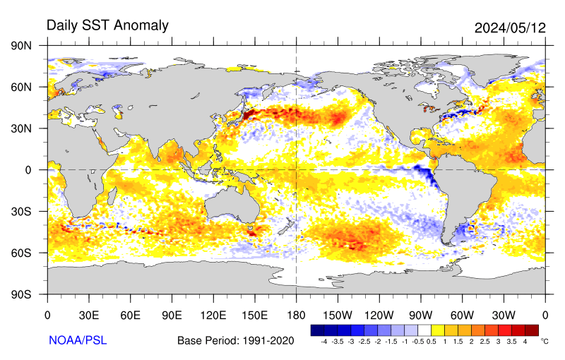 NOAA – Earth System Research Laboratory (ESRL) – Click the pic to view at source[/caption]
 NOAA – Earth System Research Laboratory (ESRL) – Click the pic to view at source[/caption]
 NOAA – Earth System Research Laboratory (ESRL) – Click the pic to view at source[/caption]
 NOAA – Earth System Research Laboratory (ESRL) – Click the pic to view at source[/caption]
 NOAA – Earth System Research Laboratory (ESRL) – Click the pic to view at source[/caption]
 NOAA – Earth System Research Laboratory (ESRL) – Click the pic to view at source[/caption]
 NOAA – Earth System Research Laboratory (ESRL) – Click the pic to view at source[/caption]
http://www.esrl.noaa.gov/psd/map/clim/sst.shtml
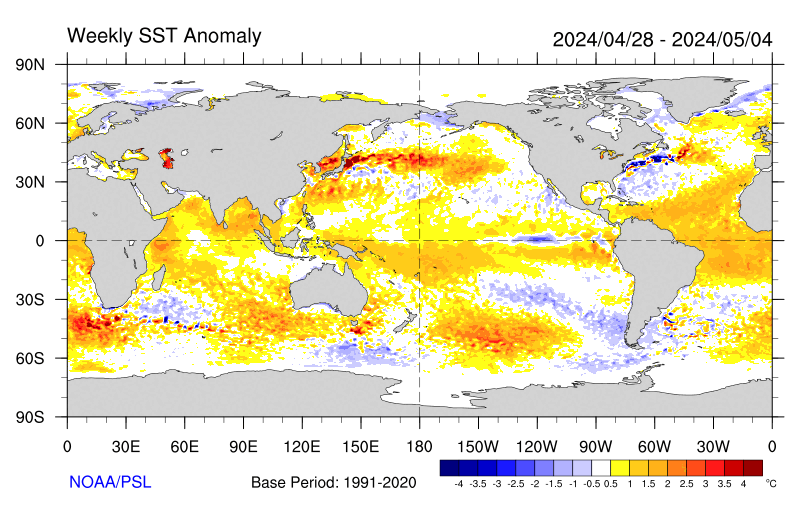
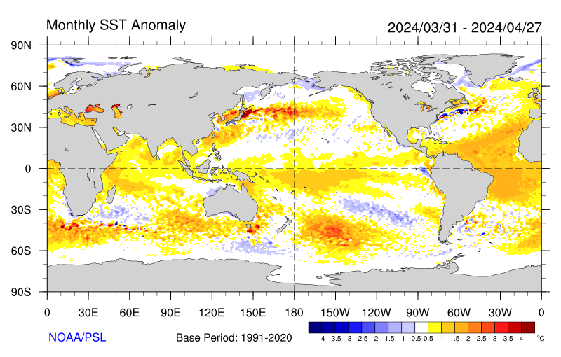
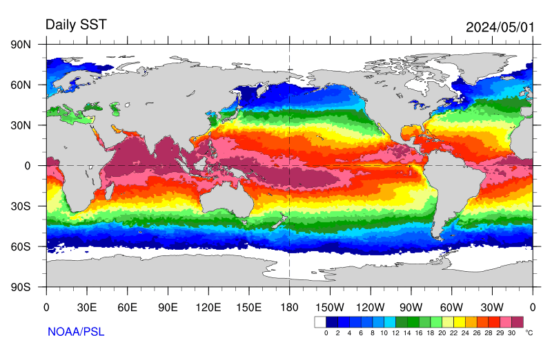
Yes, that’s very helpful I’ve added the following images to the Ocean Reference page:
Global Sea Surface Temperature Anomaly – Daily
[caption id="" align="alignnone" width="578"]
Global Sea Surface Temperature Anomaly – Weekly
[caption id="" align="alignnone" width="578"]
Global Sea Surface Temperature Anomaly – Monthly
[caption id="" align="alignnone" width="578"]
Global Sea Surface Temperature
[caption id="" align="alignnone" width="578"]
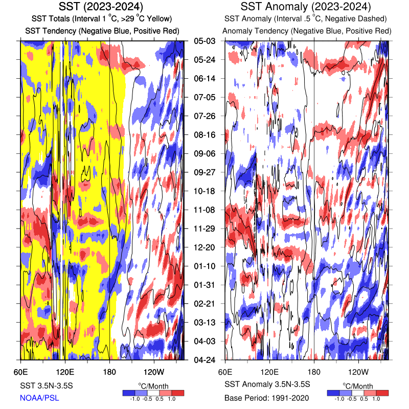
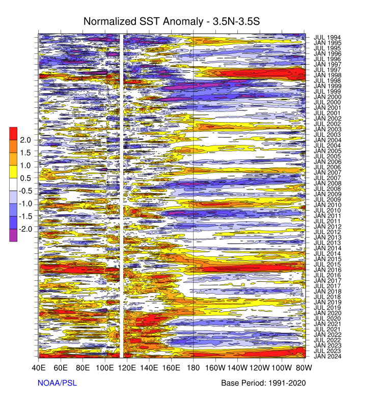
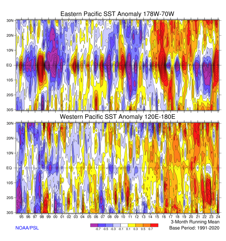
Also the following Time based Longitude/Latitude Sea Surface Temperature images are interesting in visualizing ENSO as Non-Equilibrium Pattern System:
Yearly Trends
[caption id="" align="alignnone" width="578"]
Long Term Anomaly (3.5N-3.5S)
[caption id="" align="alignnone" width="578"]
Longitudinally Averaged Anomaly
[caption id="" align="alignnone" width="578"]
Thank you
That BOM graph is particularly interesting.
It seems to disprove something that has always seem a very implausible description of what happens during ENSO variations, that is to say the idea of warm water ‘piling up’ in the west Pacific ready to ‘slosh’ back during El Nino. The language is as childish and simplistic as the model behind it.
What seems clear in these graphs is that the body of colder water is being drawn across the Pacific by the persistent oceanic gyres , not by surface, wind-driven currents. Secondly, the hotter water is not ‘piling up’ but sinking.
This would seem to more likely to indicate that there is a deep bulk water movement that I believe is inertial in origin. A very slow, deep water tidal movement in the halocline.
The “tongue”, be it hot or cold, is just the result of the convergence of the northern and southern oceanic gyres in that region.
dbstealey says: April 26, 2013 at 8:15 pm
I would save that excellent and fun question to sandbag the next presumptuous Warmist commenter pretending to pass himself off as a climate expert.
It would be even better asked in person! ☺
I can’t even get a Warmist to comment on my threads these days, there has to be someone out there who can explain how this all ties back to anthropogenic CO2 emissions… I wonder if the Warmist blog troll funding is drying up…