by Rud Istvan,
ctm and I were having lunch recently near our mutually admired South Florida coral reef system, and over conversation we started speculating about ARGO. I brought up Jason2 SLR as an analog. WUWT readers can see my 2016 WUWT guest post: ‘Sea Level Rise, Acceleration, and Closure’ for details. That ctm lunch has inspired a lot more volunteer WUWT ‘sciency’ research on whether the most modern climate research instrument systems are fit for purpose. This post covers satellite altimetry measured sea level rise (SLR). The short answer is NOPE. The eventual companion post whose results are TBD,because ‘It’s complicated, folks’, and will cover ARGO. Dunno any ARGO answer(s) yet.
There are strong evidentiary reasons to think satellite altimetry does NOT accurately represent SLR change over time. The two most irrefutable observational reasons are:
(1) Satellite altimetry measured trends are about 1.5x higher than differential GPS, (vertical land motion) corrected long record tide gauges (about 3.4 versus about 2.2 mm/yr)
(2) the dGPS tide gauge estimates roughly close, while Jason2 satellite altimetry estimates definitely do NOT. Per my previous above referenced guest post, ‘closure’ is the simple arithmetic that SLR must approximately equal thermosteric rise, as hotter seawater expands in volume, plus ice sheet losses (land based ice when melted adds ocean water), while all other contributions, such as ground water extraction are arguably de minimus.)
So, is the most recent ‘satalt bird’, Jason3, fit for purpose? Satellite altimetry uses radar signal returns reflected off a wavy ocean surface to estimate sea level from the timing of the signal from generation to receipt. This is no different in principle than any other range estimating radar system. And as many military and commercial aviation uses evidence, radar ranging generally IS fit for purpose.
Except, military cruise missile ranging is meters between Syrian aircraft bunkers, not millimeters. Commercial aviation aircraft avoidance is kilometers between planes, not millimeters. But sea level changes are measured in millimeters/yr. That is a different accuracy/precision ball game, and the logical essence of this post.
Rather than a bunch of footnotes and links necessary for ‘whack-a-mole’ guest posts like my recent ‘Antarctic SLR contributions’, this guest post simply extracts irrefutable images and numeric values from the official Jason3, (the newest satalt bird) NASA reference products and mission specs. The official ‘product’ documents are available at podacc.jpl.nasa.gov/Jason3 for any WUWT reader wanting to double check. The related Jason3 mission/physical instrument specs are available at ospo.noaa.gov. This guest post uses Jason3 product handbook version 1.5, issued 9/17/18.
Jason3 was launched into polar orbit on 1/17/2016.

It overlaps Jason2, and interestingly shows significantly less SLR in its overlap period. According to NASA, Jason3 instruments and processing algorithms correct for ‘known’, (and noted in my Blowing Smoke ebook SLR essay ‘PseudoPrecision’) Jason2 deficiencies: wave height, sigma naught, tropospheric, and ionospheric humidity. Jason3’s many new instruments now have a spatial aperture ‘pixel’ resolution of 11.2km x 5.1km, allowing closer calibration to land altitude reference pixels in order to better estimate temporal orbital decay.
The following schematic from the official Jason3 NASA information illustrates only some of the data processing problems Jason3 supposedly now ‘overcomes’.

The smaller Jason3 aperture improves its reference orbital accuracy. True. But probably not the processing algorithms for the reference Earth ellipsoid; thanks to geology Earth’s gravity field is anything but a uniform reference ellipsoid. GRACE gravimetric data shows it is a lumpy mess; which means that even though water seeks its own level, ocean seawater is NOT level across a lumpy planetary gravity field.

So, what does the latest NASA information say about Jason3’s algorithmically processed radar return data? Jason3 product manual §1.4.4 says all distance units are reported in units of 1/10 millimeter. WOW! Sure sounds fit for purpose!?!
Not quite. Following is NASA Jason3 ‘product’ manual Table 2.3.1.

For those that are NASA table challenged, the key number is IGDR actual for Total Sea Surface Height hHeightHeighight RMS, (Listed as RSS in the table above is, as noted on the associated EU Jason3 site [it’s a joint mission], just a NASA typo) precision of 3.3 cm. Not mm! This is still an improvement over Jason2, which had an SLR RMS pixel precision of 3.4 cm.
This is defined by repeated pass aperture over the same site ‘pixel’ on the lumpy Earth ellipsoid. I know of no statistics that can reduce a minimum repeatable precision error of >3 cm to an ‘average accuracy’ of 0.1 mm without a ginormous error bar, which NASA ‘conveniently’ DOES NOT provide.
An error term digression is perhaps useful for those who are not long time WUWT readers or Judith Curry “uncertainty monster” cognoscenti. There are two basic error types: precision and accuracy. The simplest layman’s explanation is from target shooting. A tight group is precision. A group on the bullseye is accuracy. An easily understood general illustration is:

NASA Jason3 information say it has BOTH precision and accuracy problems. Its ‘grouping’ precision is 3.3 cm, deceitfully reported to 0.1mm. Its accuracy is 1.5x high off what dGPS corrected long record tide gauges report. For climate purposes it is in quadrants 1/2 rather than 3/4. NOT good.
One further not-so-little satalt factoid. The Jason3 instrument drift spec (column GDR goal, last line) is identical to Jason2, ≤ 1mm/year. So the SLR acceleration that Jason2 ‘sees’ that Jason3 does not (yet) is likely just ‘in spec’ instrument drift between the two.
Ineluctable conclusion: current satellite altimetry measurements of SLR are NOT fit for climate purpose.
Excluding measurements on Land, too many fiddles, does the data from the ballons the ARGO bouys and the satilites agree, not with fractions of a degree, but overall.
Re. the rifle. f one wants accuracy then fastern down the rifle and use the same well known make of carterage. Then average out the results. Usually they will be clove enough to e able to set the sights.
In my army training days, 1944, we fired the rifles lying down, and the armoureres adjustered the sights on the new rifles.
MJE
I agree with those commenters who say the example of bullets fired at a target is not relevant to the question of whether satellite sea level measurements are trustworthy. One reason for saying this is that the satellites are not making multiple measurements of a stable target. Every measurement is at a different location, and by the time a 2nd measurement is made at the same location the tide has changed.
Also, the discussion of accuracy and precision as they pertain to firing a batch of bullets at a target is reasonable, but does not carry over to other contexts. For instance, one of my first fields of interest was astronomy. Suppose an astronomer predicted the moon was going to occult Saturn at a particular time when viewed from a particular location. If the occultation is observed to happen at PRECISELY the predicted time, then the prediction is judged to have been ACCURATE. Note that the astronomer does not make predictions of multiple events, then weigh the results. If the occultation takes place at a slightly different time, no one discusses whether the prediction was precise, but not accurate, versus whether it was accurate, but not precise.
The question of precision of the prediction relates to the difference between the predicted time and actual time of the occultation. The less difference, the more precise the prediction. Accuracy then correlates with precision.
Thus, I see 2 reasons for not thinking the analogy of bullets fired at a target is relevant to satellites making measurements of sea level.
SR
SR
Something I was taught back in grade school and as Rud points out; Close only counts in horseshoes and hand grenades” . Or cruise missiles.
A U.S. Army artillery officer I knew who had just returned from a tour in S. Korea when there allegedly were nuclear artillery shells in storage there said that close only counts in horseshoes and nuclear weapons. He also noted the oft quoted aphorism that if you get into a ring to with a skunk to settle a difference of opinion you may be right but you still come out smelling like a skunk. The latter applies to most interchanges with the alarmist community.
Sea leve measurement by gravity observation from satellites is like measuring my heigt by measuring my weigt, then guessing my body mass index while I am wearing my polar coat, and finally calculating backwards. It will never be precise.
The major problem is that the reference elipsoid (geoide) is unstable. The satellite gravity reference point – the geoides grain size gravity center point – is never in the same position in the earth center. It is moved around by various gravity changers, the moon, the planets, snow cover, atmosphere pressure, mantle movements, earthquakes, volcano eruptions, magma flow etc. How can one measure with millimeter precision when you don’t know the precise position of your refence point.
That’s like putting your target on a flag and shooting at it in a variable wind. Precision and accuracy will be gone with the wind.
Even more fun would be to be shooting from a moving platform.
Actually it’s nothing like how you guys try to portrait it is done but never let facts get in the way of a good story. What you are all basically saying is you are to lazy to read how it’s actually done. The only part anyone has currently got correct is the accuracy of jason 3 is 3.5cm how that gets to an increased accuracy escapes everyone they assume it’s just averaged … it isn’t.
If you actually care to know how they do it .. there is a key thing the satellite must do which is always fly the same path … the hint is why?
Rud if you read this stuff you only actually got half of what they do … this statement is actually the most important part of what you said
My hint is look at how they handle waves 🙂
The key to this is:
“I know of no statistics that can reduce a minimum repeatable precision error of >3 cm to an ‘average accuracy’ of 0.1 mm without a ginormous error bar, which NASA ‘conveniently’ DOES NOT provide.”
As in almost all CliSci products, there is an unsupportable belief that one can achieve high precision through simple division : averaging by whatever method of a large number of measurements.
It is simply not true. They can show whatever precision they prefer (down to ten/thousandths of a degree or fractional mm’s) but they must acknowledge the original measurement uncertainty. The uncertainty of multiple measurements of multiple things at multiple times can not be “averaged out”. It remains in the final product. Always.
Normally, no, using simple ranging, but suspect that NASA must be aware of that and will be using sar (synthetic aperture radar) techniques. That is. several views of the same area, time displaced, to create a 3d image. Then post process the resulting data set. Have done a fair amout of data aquisition for work here and the only way to increase precision is to take several samples and average, but that only works if the measured value is unchanging in relation to the overall sample period. The ultimate limitation being the resolution, the least significant bit uncertainty.
Still have dfficulty beieving that they can get repeatable and consistent mm accuracy over such a range, but who knows what techniques they are using…
Chris.
Chris ==> One problem is really that the ocean are not smooth to any degree — that is, there is not a definite “surface” (not a single ‘sea surface height’ in the sense of mm or cm distances). If you are really interested, I can dig up the pdf of the specs for the Jason series — which includes all of the expected accuracy and precision estimates.
“the Jason technical manuals show error ranges for wave height scatter in the tens of centimeters, original measurement error in the altimetry function of Jason’s 1, 2 and 3 of +/- 3.4 cm. [Ref: Jason-3 Products Handbook, pg 10]”
It would be difficult to get millimetric results if one was working with a 1km x 1km piece of ocean (in its normal state, with waves, ripples, wavelets, etc) frozen solid so it doesn’t change….even close up (standing on it?)
There are so many good essays on SLR — I offer these (some of my own and some of others):
My SLR essays at WUWT
Judith Curry’s series on SLR and Acceleration
Judith Curry’s Special Report on SLR
Rud Istvan’s series
Each of those essays have a lot of links to other essays and data sources.
As I understand it: Every height measurement ultimately depends on the ITRF which determines the location of the mass center of the earth, an ellipsoid is modeled in relation to the ITRF, the geoid model is referenced to the ellipsiod, a datum referenced to the ellipsoid is used to locate the various satellite tracking antennas and lasers that help resolve the orbital positions of the satellites in relation to the datum which is then referenced to the ellipsoid model.
Satellites measure height to an uneven sea surface which varies over time and position and the measurements are resolved as a height from the ellipsoid model. To determine heating effects, the difference between the ellipsiod model and the geoid model must be resolved since the geoid model represents where sea level should be.
A minimum of three interdependent models each with their own inaccuracies plus direct satellite measurement inaccuracies, plus orbital position uncertainty corrections, plus ITRF corrections are used to determine an average global sea level.
Considering every model and measurement and even the ITRF has an error budget that contributes to the overall measurement accuracy, I would like to see the error budget of the sea level measurements that claim to know average global sea level accurate within a tenth of a millimeter.
Radar ranging is a classic case in engineering statistics where your, say 1Ghz waveform, is actually already making one Gigameasurements per second, and whether you record the answer once a minute or a hundred times a minute simply is not going to result in “improved” results, whether the technician’s first year statistics “knowledge” says the standard deviation is the square root of 1/N better or not.
From 1980 until 1995, I spent hundreds and hundreds of days at Huntington Beach. Everything about HB has been burned into my memory.
After 15 years living in a miserable southwestern s-hole, I returned to HB to enjoy the unique and unmistakable vibe…..
One thing that was inescapable is that the sea level had receded. Absolutely, positively, without a doubt. You can parade every Ivy-League imbecile through every internet rag you like, but it will not change a thing…..
Sea levels are NOT rising…..
So-called ‘Climate Change’ is caused by fluctuations in solar activity and only fluctuations in solar activity. Not carbon emissions.
PERIOD……
According to my interpretation of the NASA table, the IGDR altimeter noise is 1.8 cm. The radar is Ku band with a wavelength of 1.7 – 2.5 cm. The noise is equal to roughly one wavelength at the highest frequency in the Ku band. The are claiming an accuracy of 0.1 mm.
This provides a Signal to Noise Ratio (SNR) of 0.006. Most analytical people agree that instruments can provide meaningful data with an SNR of 3:1. If I am interpreting the NASA chart and their accuracy claims correct, NASA is claiming that they can resolve altitude differences which are 1/540th of the signal to noise that most analytical people who I know would accept.
Did I get something wrong?
BH, maybe. But I just used what the exactly copied NASA table actually said.
Take it up with NASA. Not me as just a humble scribe.
Same ol’, same ol’ — claiming tiny differences that measuring instruments cannot measure, to begin with, and then producing hoopla on top of hoopla about those essentially meaningless differences.
High accuracy with low precision:
Two Linear Econometrists were deer hunting. One, the hunter, had the rifle, the other was spotting with binoculars. Lo and behold they saw a nice buck on a hillside quite some distance away. The hunter aimed and fired, kicking up dust three feet to the right of the buck, but with good elevation. “Three feet right!” exclaimed the spotter. The hunter compensated and fired again. This time the dust kicked up three feet to the left of the buck. “Got him!” exclaimed the spotter.
SLR estimate are definately fit for purpose.
What’s the purpose?
If you are palnning long term infrastructure projects ( say a nuclear power plant )
you want to insure that the area wont be flooded.
Even it the error was huge in SLR it would still be fit for this purpose.
How about if you own beachfront property in San Diego, and the government wants to condemn your property because of assurances that, although not currently a problem, acceleration of sea level rise assures that this area is unfit for human habitation.
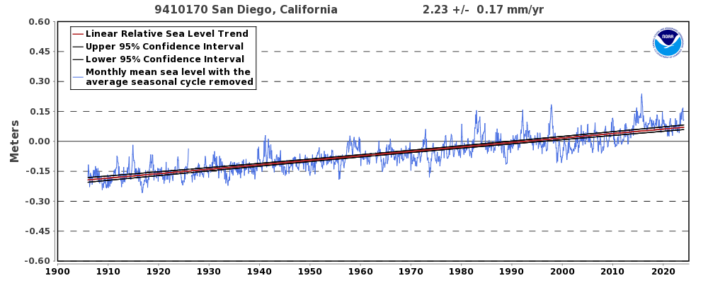
But in reality there is no acceleration, sea level in that area has barely risen in 100 years, and bogus data and fear mongering are the entire basis for the fact that you are about to have your home taken from you?
Meanwhile you cannot sell for a fair price because of all of the misinformation flying around, and may not be able to sell at all.
https://www.jdsupra.com/legalnews/california-coastal-commission-to-30729/
Now you are not even trying Mosher, you build the sucker 30 feet above the highest tide ever recorded, not on a possibly slipping fault, and in an area not known for “tidal waves”.
Cooling water always a consideration…and NIMBY.
Steven Mosher: “Even it the error was huge in SLR it would still be fit for this purpose.”
If the error were so huge that the sign is unclear, I believe that you would agree that the fitness becomes questionable.
SO if the error was so large that the 1.7mm/decade was reported as 30m/decade, would you then only permit nuclear power plants located at least a thousand feet above sea level? After all, you want to insure it won’t be flooded! Obviously, a realistic Sea Level Rise prediction should be considered when making long term plans, but a huge error can have huge negative impacts.
It is difficult to measure sea level from a satellite.
From the Jason 3 handbook, it states that the satellite revisits the same spot above the earth once every 10 days. That informs us that each square of earths ocean is measured 36 times per year.
Those 36 measurements will include all tides, currents, waves, storms, depressions, lunar and solar influences on the surface level measurement.
Not many measurements to come up with a sub millimeter, accurate, value, I suggest.
In addition, the orbit height accuracy tolerance is 1cm.
https://en.wikipedia.org/wiki/Jason-3#Orbit_Determination_Instruments
Rud: Missed this article earlier. FWIW, I once spent a lot of time looking over some of the satellite altimetry documentation. I came to several tentative conclusions: 1) The drift in satellite altitude (above the geoid) is at least 1 cm/yr, so they aren’t measuring the distance from the satellite to the sea surface in the same way that GPS works – by knowing the orbit of the satellite. 2) I saw lots of information about calibration and validation – measuring the height of the satellite by measuring the distance to a known site on the surface. One of the first sites I read about was Harvest, an abandon oil drilling platform off the Southern CA coast with a GPS receiver to track local vertical land motion. And, of course, the platform must contain a tide gauge to determine local sea level as the satellite passes over. 3) A variety of such calibration sites appear to be used and tested against each other for consistency. 4) So satellite altimetry appears to have become a measure of sea level relative to calibration sites with GPS and tide gauges.
Many large corrections in distance are made for humidity, waves, and the ionosphere. Some of these rely upon re-analysis data and the inputs to re-analysis are changing over time. Any bias in measuring humidity over time or wave height turns into a bias in SLR. The potential for systematic error is large and there have been a number of large corrections for such errors already. I’m not surprised that Jason 3 disagreed with Jason 2 during their period of overlap, but I predict some systematic correction will be found to eliminate this difference. Two independent sets of satellites were used to complete two independent assessments of SLR – and then changes in data processing were made so that they agreed.
Five different groups publish satellite altimetry results. How independent are they? Do they each start with the same raw data and process it from scratch? Or does one team determine satellite altitude for everyone. Does each group compile their own data on wave height, humidity and the ionosphere and independently convert time for pulse to return to distance, or is their a single team doing these calculations too? I know they independently grid their data to produce separate global records.
Take all of the above info skeptically. I didn’t take proper notes of what I was reading as was confused most of the time. None of this story is clear to me from any one publication. But it might provide some useful hints about what to look for.