Sudden Stratospheric Warming, Powerful El Niño Combination May Lead To Extreme Europe Cold, Energy Crisis!

From the NoTricksZone

By P Gosselin

Extreme cold threatens Europe, energy crisis… When two of the planet’s most powerful climate phenomena align in an unprecedented surge, atmospheric scientists pay close attention.

Meteorologists like Joe Bastardi are closely monitoring a dramatic interplay high above the Northern Hemisphere – namely an exceptionally strong El Niño in the tropical Pacific coinciding with a massive Sudden Stratospheric Warming event. Their simultaneous occurrence creates an unusual atmospheric setup that could fundamentally reshape Europe’s coming winter.

Polar wind reversal

To understand what this atmospheric doubleheader means for the continent, we need to look miles above the Arctic Circle. Under normal winter conditions, a tight ring of high-speed westerly winds known as the stratospheric polar vortex traps bitter Arctic cold safely within the high latitudes. During a Sudden Stratospheric Warming event, temperatures high in the stratosphere rise dramatically over the course of just a few days, weakening or completely reversing those polar winds.

The next 2 to 6 weeks

Over the following two to six weeks, this high-altitude disruption will trickle down into the weather layers below. The result is often high-pressure blocking over Greenland or Scandinavia. When such blocks form, the mild, moist winds coming off the Atlantic Ocean get blocked and open the way for a direct channel for arctic or continental air masses to flow out of Siberia and the Arctic Circle straight into Northern and Central Europe. Historically, events like the “Beast from the East” in 2018 were driven by this exact atmospheric mechanism.

Enhancer El Nino 

Adding a powerful El Niño to this equation introduces a second major force. El Niño warms the equatorial Pacific, releasing massive amounts of heat into the atmosphere and altering the position of the jet stream thousands of miles away. Crucially, El Niño enhances the giant atmospheric waves that travel upward into the stratosphere, frequently preconditioning the polar vortex for a sudden breakdown.

Europe: increased probability of prolonged intense cold and snow

When these two forces merge, Europe is likely to experience a stark atmospheric divide. For Northern, Central, and Eastern Europe, the stratospheric breakdown remains the dominant player, sharply increasing the probability of prolonged freezing spells, intense frost, and snow. Meanwhile, Southern Europe and the Mediterranean face a very different winter under the southern storm track, marked by frequent low-pressure systems bringing heavy rains, strong winds, and significant mountain snowfall.

Odds tilted toward a severe, prolonged winter freeze

Where these two contrasting air masses meet—often across a swath stretching from northern France through Germany and Poland—a high-conflict weather zone can emerge. These boundaries frequently trigger severe winter storms capable of producing heavy snowfall, freezing rain, and ice storms. Moreover, with global ocean temperatures remaining elevated, Arctic air crossing the warmer waters of the Baltic and North Seas could pick up extra moisture, delivering heavier localized snow events along coastal regions than a standard cold outbreak might produce.

Blocking high position as the key factor

Several critical variables will ultimately determine whether this atmospheric potential translates into a historic freeze on the ground. The most decisive factor is the positioning of the Scandinavian high-pressure system. If the blocking high parks directly over Scandinavia, Central and Northern Europe will bear the brunt of the cold as Arctic air sweeps uninterrupted across the continent. However, if that high pressure shifts even a few hundred miles to the west over the Atlantic, the Arctic air could easily miss Western and Central Europe entirely.

Ultimately, while the combination of a strong El Niño and a major stratospheric warming heavily tilts the odds toward a severe, prolonged winter freeze, the exact geographic placement of the high-pressure block remains the single element that dictates which regions face deep sub-zero temperatures and which experience only a routine winter chill.

 Heightened Europe energy volatility

Germany’s gas reserves are starting winter at extremely low levels, leaving virtually no margin for error during cold spells. If winter brings a prolonged Arctic cold snap driven by a Sudden Stratospheric Warming event, daily gas withdrawal rates will spike sharply. Without a robust cushion in underground storage, sudden increases in demand will trigger sharp market panic and drive short-term energy prices up exponentially overnight.
The climate data they don't want you to find — free, to your inbox.
Join readers who get 5–8 new articles daily — no algorithms, no shadow bans.
5 29 votes
Article Rating
Subscribe
Notify of
46 Comments
Anthony Banton
October 25, 2026 10:50 pm

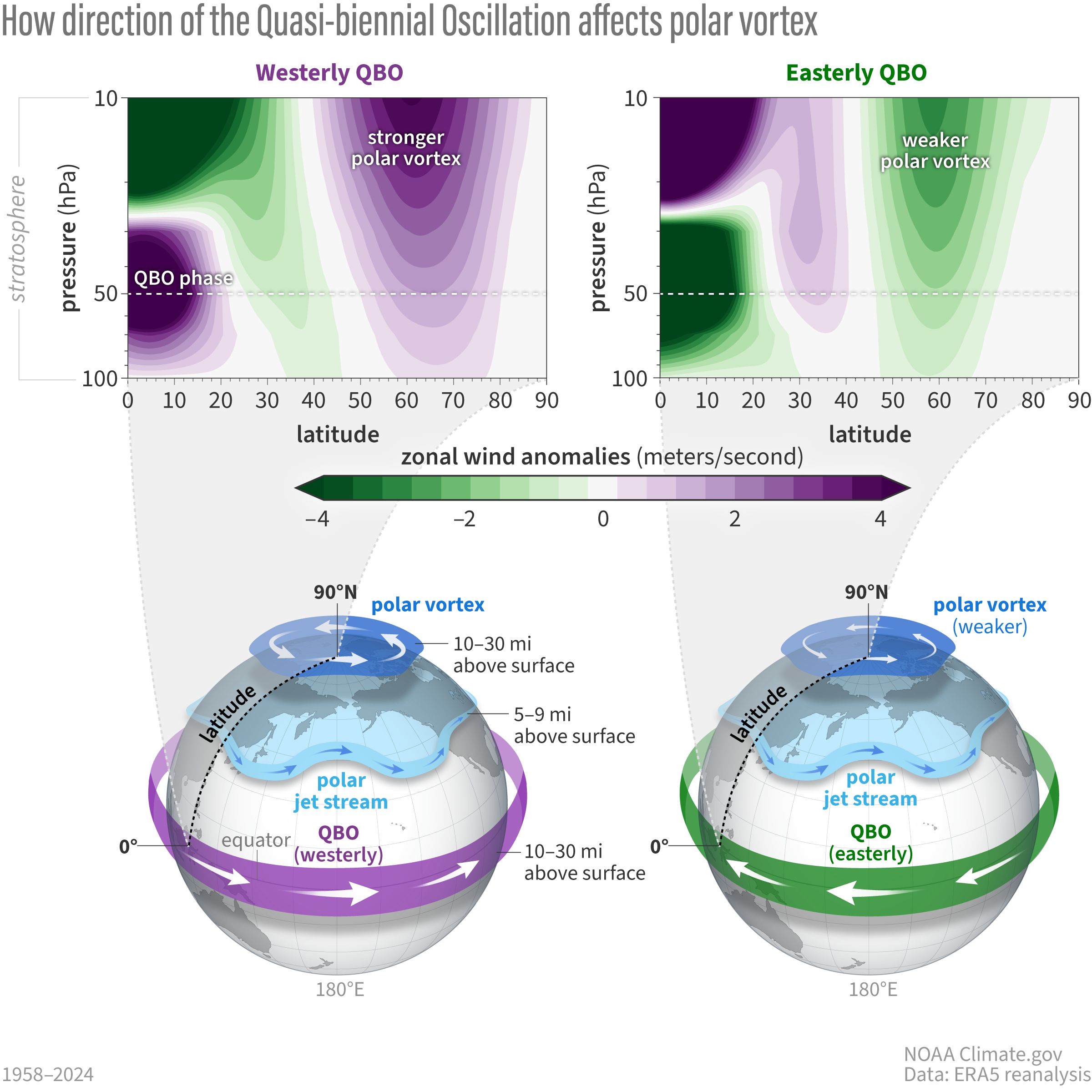
Mr Bastardi has not included the effect that the presence of a westerly Quasi Biennial Oscillation is likely to have on the Polar vortex this winter in his speculative post…..

https://www.weather.gov/arx/winter2627outlook

”The Quasi-biennial Oscillation (QBO) will be from the west this winter (Dec-Jan). This results in the polar stratospheric winds being stronger than average (purple). This makes sudden stratospheric warming less likely to occur; thus, less Arctic Outbreaks when combined with a very strong El Niño.“

comment image

Scissor
Reply to  Anthony Banton
October 26, 2026 4:06 am

What is the evidence for the claim about Joe Bastardi?

Anthony Banton
Reply to  Scissor
October 26, 2026 6:45 am

My apologies to Mr Bastardi …

His name was merely used as an example in this NoTricksZone article by
Gosselin.

I should have know better.
Mea Culpa

Scissor
Reply to  Anthony Banton
October 26, 2026 7:14 am

Perhaps you also owe P Gosselin an apology also as it would be unusual for meteorologists not to be monitoring the situation he describes.

Anthony Banton
Reply to  Scissor
October 26, 2026 2:21 pm

Certainly not.
He above has attributed incorrect climate science in order to make a specious political point.
IOW: More “Fake news” entering the polarised discourse the world has that in no way is helpful.
Also October is to early to arrive at any conclusions about the coming winter beyond resort to metrics like the ENSO state the QBO (and Solar activity), except in the sense that Met are always monitoring the weather.
That’s what the profession has to do – weather never stops it’s 24/7.

DipChip
Reply to  Anthony Banton
October 26, 2026 7:35 am

The worst problem with Mr Bastardi’s forecasts are they have been consistently more correct than the official forecasts. .

Anthony Banton
Reply to  DipChip
October 26, 2026 2:23 pm

As a retired professional Forecaster, I differ considerably in my opinion.
As I have read some of them on here whilst monitoring the Synoptics myself.

Mr.
Reply to  Anthony Banton
October 26, 2026 9:43 am

So your cited event is “likely”, while you claim Bastardi’s are “speculative”.

Isn’t “likely” also “speculative”?

Anthony Banton
Reply to  Mr.
October 26, 2026 2:26 pm

It is.
Tele-connection “forecasting” months in advance is and always will be “speculative”.
A matter of considering probabilities gained from past data.

Only NWP forecast within a ~ 5 day period could be considered not.

Mr.
Reply to  Anthony Banton
October 26, 2026 8:39 pm

Mmmmm.
A serve of fresh word salad.

October 25, 2026 10:57 pm

So whether we have a normal or beastly winter is in the lap of the gods and a depression. It’s enough to make one really depressed. As to whether in the UK we have enough electricity will depend on how windy it is, as we will be otherwise dependant on the kindness of strangers, aka imported electricity, as our reserves of gas are pitiful and the licencing of the Jackdaw gas field has been left to the last minute thanks to the environmental challenges, environmentalists and judges. Even if it is very windy the grid will struggle to get the electricity to where it is needed.
Rant over.

Ex-KaliforniaKook
Reply to  StephenP
October 26, 2026 10:03 am

It’s a pity that when gas reserves start to run low that you can’t withhold it from politicians, judges (a subset of the political class in many cases) and environmentalists. They say they don’t need fossil fuel products anyway.

Reply to  Ex-KaliforniaKook
October 26, 2026 12:14 pm

Yes I agree, and put Ed and Miatta at the head of the list.

MrGrimNasty
October 26, 2026 1:29 am

We haven’t had a proper beast from the east reach the UK for many years. March 2013 was probably the last.

The hyperbolic press has labelled several bits of weather since then as beasts, but they were more like Mice from Moscow. One was a little bit rabid, think it was 2018, but all the others were complete non-events.

George Thompson
Reply to  MrGrimNasty
October 26, 2026 2:24 am

Nice turn of phrase…or two. Rabid-I like that.

Scissor
Reply to  MrGrimNasty
October 26, 2026 5:27 am

In Colorado, I’m looking forward to a ski season that is more friendly to the bottom of my new skis.

Currently, a large swath of precipitation is moving through the state dropping a lot of rain in the Denver metro and snow in the mountains. I’m looking forward to sunrise so that I can see the newly snow covered peaks to the west.

Scissor
Reply to  Scissor
October 26, 2026 6:45 am

Rain has ended but it’s still too cloudy to see the snow. Visibility is supposed to improve throughout the day.

Steve Bunten
Reply to  Scissor
October 26, 2026 8:48 am

I live in SE Aurora next to the Aurora Reservoir and really haven’t seen much rain. We got a bit a couple days ago in the evening and I guess we got some overnight last night but yesterday was a beautiful sunny autumn day. The southwest part of the state was inundated with rain with severe flooding but essentially no snow. We surely need more rain (but not the downpours they got) and a lot more snow in the mountains to replenish the reservoirs–I’ve never seen the Aurora Reservoir anywhere near as depleted as it is right now.

Mr.
Reply to  Scissor
October 26, 2026 9:49 am

Where I live,
“it’s beginning to look at lot like Christmas”


Mt-Washington
Ex-KaliforniaKook
Reply to  Scissor
October 26, 2026 10:21 am

In the Reno area we are promised the ski runs (Mt Rose Ski Tahoe) will be open November 20. I can see the runs are covered with snow now – some natural, some artificial. The Mt Rose Ski Tahoe is next to the actual Mt Rose, the bowl of which is covered in natural snow now, but only accessible after a four-hour trek (if you’re in good shape) or helicopter. It’s not deep enough to ski safely yet, but it all looks very promising this year!

October 26, 2026 2:00 am

Whatever it is like in Western Europe, it is going to be hell on wheels in Russia, and to a lesser extent, Ukraine.

General Winter is not taking sides.

Neil Lock
Reply to  Leo Smith
October 26, 2026 8:39 am

Oh, but he has taken sides in the past. Against Napoleon in 1812, and Hitler in 1941/2.

Bruce Cobb
October 26, 2026 3:40 am

Whatever happens, it will be due to “carbon heating”.

oeman50
Reply to  Bruce Cobb
October 26, 2026 4:02 am

Indeed, “climate change” is responsible for all weather that is even slightly out of the norm. Wait…what? Climate is not weather? Never mind.

Scissor
Reply to  Bruce Cobb
October 26, 2026 4:09 am

For my hot shower this morning, I thank carbon heating.

Neil Lock
October 26, 2026 7:10 am

This seems like a rather alarmist article from someone with “previous” in telling the truth, rather than fanning fear? But I suppose it may be an essay in turning our enemies’ techniques back on themselves.

Whichever, Mr Banton, a former Senior Meteorologist at the Met Office, fell into the trap.

Steve Bunten
Reply to  Neil Lock
October 26, 2026 8:55 am

I guess I didn’t read it as alarmist rather than a warning based on past experiences when these two meteorological events occur at the same time. And given western Europe’s headlong drive to Net Zero and abandoning reliable production of electricity and natural gas the citizens of those countries can look forward to a miserable winter.

Erik Magnuson
Reply to  Neil Lock
October 26, 2026 12:43 pm

The article does come across as alarmist, but we should know in a few months whether reality upholds or refutes the alarm.

Anthony Banton
Reply to  Neil Lock
October 26, 2026 2:36 pm

Yes, and gladly.
I love debunking bollocks written about meteorology.
And plenty appear on here from that oxymoron of a Blog NoTricksZone.

But my fav has made a guest appearance on another thread here – Mr Homewood.
Every time he appears the oh so sceptical on here accept his bollocks and axe-grinding denigration of UKMO forecasts/warnings when my basic fact-checking shows them to be just that …. bollocks.

October 26, 2026 8:50 am

.
Ah, ha ha ha ha ha ! ! !
.
Just when Europe needs Russian hydrocarbons, the EU is urging Ukraine to destroy Russian hydrocarbon production.

October 26, 2026 8:51 am

From the above article’s second paragraph:

“Meteorologists like Joe Bastardi are closely monitoring a dramatic interplay high above the Northern Hemisphere – namely an exceptionally strong El Niño in the tropical Pacific coinciding with a massive Sudden Stratospheric Warming event.”

Now wait just a moment! This totally dismisses (via absence of mention) the effects due to the Hunga-Tonga underwater volcano eruption of January 2022 that injected “massive amounts of water” directly into the stratosphere.

Many posters here on WUWT have argued that long term effects of such injection of water vapor on Earth’s weather cannot be underestimated.

Why is it now being so easily overlooked? No reason at all to believe that water vapor couldn’t wait, oh, some 4+ years to join in an “interplay” with other factors, right?

/sarc

Reply to  ToldYouSo
October 26, 2026 11:48 am

My earlier response might be viewed as an answer to your query about Hunga Tonga. There has been extraordinary warmth over the N Hemisphere for the past few winters, which has clearly nullified for the most part, much of what might be normally expected of blocking highs to the north.

Reply to  Neutral1966
October 26, 2026 12:32 pm

“My earlier response might be viewed as an answer to your query about Hunga Tonga.”

It might, but that is extremely unlikely. You see, “blocking highs”—even regular high and low pressure weather systems—are associated with the troposphere, NOT the stratosphere.

Are you now trying to assert that the Hunga-Tonga eruption injected liquid water/water vapor that has persisted in the troposphere for 4+years? 

Reply to  ToldYouSo
October 26, 2026 12:50 pm

No, that’s not my assertion at all.
What I am “suggesting” might be possible…. is as follows.
. Recent SSW events that have encouraged the development of northerly blocking highs, have had impacts massively diluted by residual warmth over the N. Hemisphere.
. That residual warmth is of course found in the Troposphere. Why that residual warmth is so prevalent is open to debate…..eg …
….. Hung Tonga; AGW; cloud dynamics; natural cycles; reduction of aerosols; combinations of the above; etc, etc …!
I certainly don’t /wouldn’t presume to present any view at all – just one of several “possible” explanations🧐🤓😉

George Thompson
Reply to  ToldYouSo
October 26, 2026 6:20 pm

I read that Hunga-Tonga blew some 150 million tons m/l of water up into the stratosphere and the debates among people who know a Hell of a lot more than me were quite interesting as to what overall effects that much water would have on the troposphere below and energy balances, etc. It does seem that much of our crazy weather could be an effect of that. I don’t know, and cause and effect is very often much too cute and too easily assigned, but I would like any good discussion on that. Anybody? Atmospheric physics is quite beyond me.

George Thompson
Reply to  George Thompson
October 27, 2026 4:03 am

A down vote for asking a respectful question? Tsk. Somebody should be ashamed.

October 26, 2026 11:24 am

“However, if that high pressure shifts even a few hundred miles to the west over the Atlantic, the Arctic air could easily miss Western and Central Europe entirely.”
This statement is a bit misleading! If the blocking high moves from being parked over Scandinavia to being parked over Greenland instead, this raises, rather than lowers the probability of Western Europe being affected. Parked over Scandinavia, Eastern and Central Europe are more likely to bear the brunt.
But with all such events, much depends on how much of a cold pool has been established within the source region. The “beast from the east” can for example, be more likely to be the least from the east, if there isn’t enough of a cold pool already established over western Siberia and Russia. Recent winters have seen blocking highs to the north, that have turned out to engage damp squibs of easterlies.
Even with powerful blocking highs established over Greenland, the cold air that this produces plunging south has been relatively short-lived. As this cold air has met with extraordinary warmth in the N. Atlantic, the powerful low pressure systems that this generates, allows strong southerly and southwesterly airstreams on their eastern flanks, to quickly obliterate any incursions from the north.
As a result the polar front migrates much further north. This has been the case, even with SSW events. There needs to be a much more extensive cold pool over Russia and Western Siberia, together with less warmth in the N. Atlantic this winter, for any combination of SSW and El Ninõ, to bring about deep cold that lasts for more than just a few days. Current indications suggest that those criteria are not in place, as we move towards late Autumn/Fall.

Reply to  Neutral1966
October 26, 2026 1:18 pm

https://wetterzentrale.de/en/topkarten.php?map=2&model=cfs&var=2&run=12&time=408&lid=OP&h=0&mv=0&tr=24#mapref

Just to illustrate the above. Here’s the CFS forecast for 18 days time – a proper Scandi blocking high. Although not likely to realise at this range, the model is obviously picking up the the lack of cold pool over W. Russia and Baltic states. Result: an E/NE airflow over the UK producing probably nothing colder than average temperatures. Normally, we would expect at least reasonably cold temperatures over the UK in mid November from such a wind direction.

Running the sequence to a few days later, the high migrates gradually to Greenland, eventually generating a northerly airflow over the UK and W. Europe. The cold feed is then quickly cut off by LP from N. Atlantic.

Edward Katz
October 26, 2026 2:18 pm

As in all these forthcoming climate disaster stories the key words are “may lead” which really means no more than there’s a possibility. Except there’s also a possibility that it “may lead” to nothing more than a normal winter or even one that’s above normal, and if those occur, it’s a guarantee that that the alarmists will quickly deny any such predictions were made to begin with.

Reply to  Edward Katz
October 26, 2026 4:15 pm

Much more likely that they would claim that all the Net Zero initiatives were working, so all the more reason for doubling down on eradicating fossil fuels.

October 26, 2026 5:01 pm

So, the large El Nino presence may cause cooling over parts of Europe.

Meanwhile… down south in the important hemisphere, the El Nino is also having an effect at the south pole latitudes

Ozone hole
https://ozonewatch.gsfc.nasa.gov/meteorology/figures/ozone/to3areas_2026_toms+omi+omps.pdf

55S to 75S atmospheric temperature
https://ozonewatch.gsfc.nasa.gov/meteorology/figures/merra2/temperature/t55_75s_100_2026_merra2.pdf

45S to 75S 150 hpa wind speed
https://ozonewatch.gsfc.nasa.gov/meteorology/figures/merra2/wind/u45_75s_150_2026_merra2.pdf

The CFC – Ozone destruction / dilution theory must be pretty punch drunk by now, its the biggest in 20 years, and its not over yet.

These atmospheric gas theories, they remain theories, even with the evidence clearly showing that they are BS, and only kept alive by politics and cash.

Have a wonderful day

October 26, 2026 7:16 pm

Unprecedented

KevinM
October 26, 2026 8:00 pm

“February 24, 2022, when Russian forces launched attacks across northern, eastern, and southern fronts from Russia, Belarus, and Crimea.”
After almost 4 years theere should be new supply lines.

Andrew St John
October 26, 2026 10:11 pm

Sorry but I am NOT buying this little piece of speculation.

The sky might start falling, as well.

October 27, 2026 6:43 am

So maybe another “Beast from the East” this winter, at least it will remind children in the UK what snow looks like 😉

October 27, 2026 7:44 am

Before we try “to understand what this atmospheric doubleheader means for the continent”, shouldn’t we first understand that “a massive Sudden Stratospheric Warming event” is really quite common, i.e., nothing unusual at all? I can’t understand why such an event should be capitalized.

This, from NOAA’s website https://www.climate.gov/news-features/blogs/polar-vortex/polar-vortex-double-header :
“If we were summarize the entire observational record since the 1950s, we’d say major sudden stratospheric warming events typically occur every other year or so. Some years have no major warmings. When they do occur, they’re most common in January or February. What’s less common is having them in both January and February or, for that matter, twice in any winter season.”
[my bold emphasis added]

ROTFL.