From NOT A LOT OF PEOPLE KNOW THAT
By Paul Homewood
Eunice is on the way –stay safe:

https://www.bbc.co.uk/news/uk-60417263
There is no doubt according to the forecasts that Storm Eunice will be one of the strongest storms in recent years. The Bristol Channel area will be particularly affected.

In true BBC fashion, however, they have hyped it up into something it is not, or at least hopefully won’t be:

https://www.bbc.co.uk/news/uk-60417263
So let’s get this absolutely straight now, the Burns Day storm was much, much worse:

Bear in mind these are knots, not mph – 1kt = 1.15 mph. Wind gusts of over 80kts plus (92 mph) were widespread inland and away from highly exposed coastal sites. Top speed was 107 mph at Aberporth. Avonmouth clocked 97 mph while Sheerness across in Kent went higher at 101 mph.

The latest Met Office forecast suggest winds of 80 to 90 mph along the Bristol Channel. There is nothing to suggest anything much above 90 mph. except at the top of a high, exposed cliff top.
Further north, winds of 70kts and over (80 mph) were widespread in 1990. Here in Sheffield we are expecting maximum winds of 60 mph tomorrow:

Sadly I have no doubt that the BBC/Met Office will cherry pick a few cliff top and high level sites to claim 100 mph winds. Shame on them if they do, for making political propaganda out of a human tragedy.
Storm Dudley
While we’re at it, let’s take a look back at Storm Dudley, which I seem to recall had forecasts of over 100 mph winds.
In reality, it turned out to be just a typical winter storm. As usual the Met Office use unsuitable and unrepresentative sites for top gusts. Capel Curig is half way up a mountain in Snowdonia. Emley Moor, which I often cycle up, is about 800 ft up where the ITV TV mast is, and so on.

One of the saddest things about the Met Office’s determination to give every storm that passes our way a silly name is that it detracts from the really memorable events.
In twenty years time, who will remember Eunice? It will just be another in a long line of run of the mill storms. By contrast, the Burns Day storm or the Great Storm of 1987 will rightly be remembered for many years to come, precisely because they were extraordinary and were rightly named as such at the time.
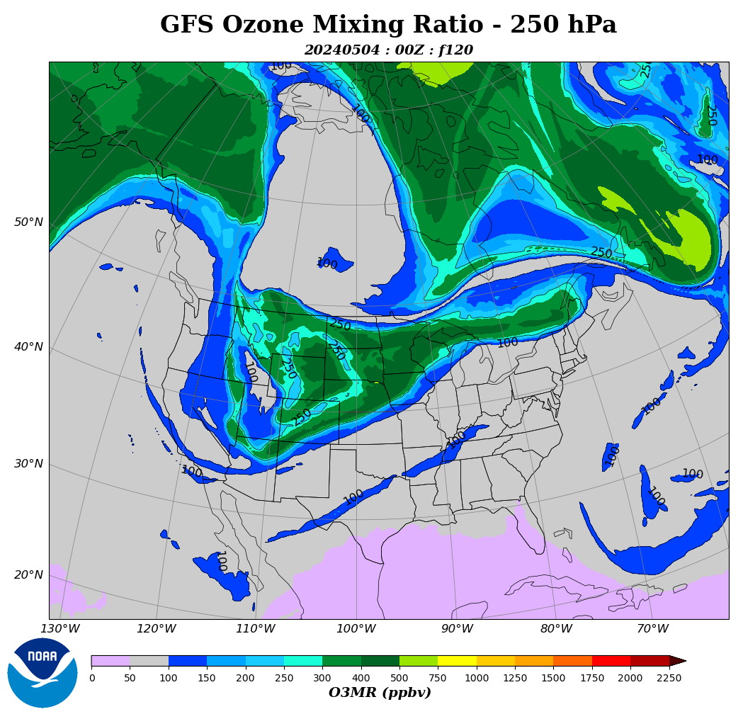
Let’s look at the distribution of ozone in the stratosphere in the northern hemisphere. It shows the polar vortex pattern. Where the ozone is arranged latitudinally the polar vortex and the jet stream current is stronger. You can now see a strong westerly circulation in the Atlantic.

This circulation in the Atlantic will continue over the next few days. It will be different in the Pacific, where the polar vortex will be blocked and the jetstream will drop south over North America.
It’s a good thing the climate alarmist industrial complex was not invented until after WW2. Otherwise D-Day might not have happened out of an abundance of caution for wind plus carbon emissions and the UK would have gone on to become a moonscape of V2 rocket craters.
You can see the significant temperature difference over the UK, and it’s already snowing in Scotland.
The low is pulling cold air from the north over the UK, which promises more snowfall.
Well, they’ve done it. My TV is showing 122mph at the Needles, a new all-time record. How much trust to put in it, I do not know.
With such a temperature difference, it must be blowing hard.
That seems scarcely believable.
From the Bournemouth seafront, you can see the Needles a few miles away. Bournemouth has had no noticeable damage. Only the odd small branch in the streets, and no damage at all either from wind or waves on the seafront, despite the strongest winds coinciding with a high spring tide.
I wonder if the anemometer at the Needles is inside a channel which funnels the wind through it in some way, such as you sometimes get between tall buildings
Is the anemometer not on the lighthouse?
The wind speed for the Needles is measured by an anemometer sat on top of a building, sat on top of a cliff on the western point of the island.
It invariably measures the highest wind speeds for the south of England for obvious reasons and bears little relevance to the rest of the country, even to the other side of the island.
As you rightly point out, wind speeds in the general area were not comparable.
Of course you’ll never see that explained in a tabloid headline…WINDIEST EVAH!!
Daniel Schmidt, CC BY-SA 4.0 <https://creativecommons.org/licenses/by-sa/4.0>, via Wikimedia Commons
Thanks for that information. Yes, it does look like a standard exposure. I know they often get the highest gust along the south coast in stormy weather, even compared with other coastal promontories, such as Portland Bill.
Nevertheless, I’m still amazed that a few miles from the airport at Bournemouth, 5 miles from the coast, max gust 76 mph, there could be such an extraordinary gust. I was down on the seafront at the time, and the Needles were clearly visible in bright sunshine. I must have seen it happen – what excitement!!
Getting back to this a few days later…..!!
I was intrigued to read in yesterday’s Times on-line, another slightly disbelieving article about the 122 mph at the Needles. It pointed out a few anomalies.
It was higher than the highest gust in the Great Storm of 1987 (115 mph), and also the Burns Day Storm of 1990 (104 mph), both of which resulted in considerably more damage – for example, an estimated 15 million trees were felled in 1987, compared with about one million this time around.
Also, other gusts at similarly exposed locations nearby didn’t even reach 100 mph, and more typically were around 90 mph.
I haven’t been able to find a copy of the anemometer trace for the day in question, but I did notice that, as the storm was building up that morning, there were occasional gusts in the 90s at the Needles, followed by one of something over 100, and then the 122.
The Times article suggests that the shape of the cliffs below the anemometer could possibly be responsible for a very localised acceleration in the wind speed, caused by a type of Venturi effect, but this would be dependent on the exact direction of the wind during the strongest gusts.
Perhaps we shall never know. After all, this is just speculation. But, who knows, maybe the Met Office will put some effort into having a closer look at “England’s strongest wind”??
Probably a bit late for most of the press, who have already moved on from their headlines stating “122 mph winds batter Britain”, as though such winds swept the whole country all day
Only a record for England not he UK.
The strongest gust ever recorded in the UK was 173mph at Cairngorm summit in the Highlands of Scotland in 1986
“The strongest gust ever recorded in the UK was 173mph”
That’s impressive!
Griff would faint dead away if that happened today. He would swear it was the work of the evil CO2.
The low has swept over the UK and is now over the North Sea. Snowfall in Denmark and strong wind on the continent, will intensify overnight.
Strong zonal circulation with an admixture of Arctic air in the UK for the next few days.
I’ve been out walking in both Dudley and Eunice, and neither was particularly special:
http://www.honestcommonsense.co.uk/2022/02/storm-dudley-was-dud-was-storm-eunice.html
Climate blame communications has become boilerplate language.
Brazil’s deadly mudslides reflect neglect, climate change – ABC News (go.com)
Dangerous squall line enters Poland from Germany. It can break trees and tear off roofs. During the night over the Baltic Sea there will be a center of low pressure below 970 hPa.
It has been comical to watch MSM and the green blob hysterically obsess about this normal average storm – the human species is doomed
Meanwhile, winter is in full swing in North America.
I smell spring in the air here in the central U.S. We’re going to get a few more cold blasts that last a couple of days but the warmups are coming quicker, some of the wild flowers are blooming and the birds are back.
it looks like the eastern third of the U.S. is going to suffer the brunt of arctic air.
We are now past the coldest part of the year, heading towards spring. I need to order some garden seeds. 🙂
Actually, the saddest thing about naming storms is, eventually one had to be named Eunice.
The ‘Sun’ newspaper is claiming 122mph winds.
https://www.youtube.com/watch?v=I1R64mly8y0
Funny how the camera just happened to be there when these men were blown over.
On Wednesday the BBC were forecasting wind gusts of 40mph or more for where I live. All day long the trees hardly moved.
On Thursday they forecast hail showers all morning and until 2pm. We got one very brief hail shower lasting about 5 minutes.
Today they were forecasting heavy snow all morning. We had a wee bit of snow early in the morning and then nothing, By noon the little snow we had had virtually all melted away.
To get it wrong once can be regarded as a misfortune; to get it wrong twice looks like carelessness. I wonder what Oscar Wilde would have made of getting it wrong three times.
perhaps it is time to stop the silly names and number them annually eg 2022 – 1, 2, 3 etc. We need to make sure there is a realistic definition so the climate crazies can’t call a normal storm a big event like this. Numbering would make it much clearer however many storms there were beyond a particular size and should stop the nonsense we get about worst year ever.
That sounds like a good idea to me. The climate change propagandists may not like it, though.
Tonight’s BBC news was all about Eunice. They were desperate to make something of this very minor event. And of course the warmers were invited to drivel on about how this was going to get worse. TV news is becoming less and less watchable.
One of these days all of this climate change insanity will be seen for what it is.
A front from the south brings snow to the UK.
This is what Griff said on February 18, 2022 1:18 am:
This is what the Met Office says:
Its one thing to disagree. This is something quite different, this is intellectual dishonesty. Anyone can find the Met Office views very easily. They have declined to attribute Eunice to Global Warming, and have clearly stated that there are no trends in UK extreme weather events, so there is nothing to explain by citing Global Warming.
Question therefore to Griff. Do you accept the Met Office account? If not, why not? And if you do, do you now agree that the weather in the UK has definitely not changed since 2000, and that there is nothing about it that requires the invocation of climate change or anything else to explain it?
There really is nothing to see here, and even the Met Office, which is thoroughly sold on the climate change hysteria, can see it and admit it publicly.
“Anyone can find the Met Office views very easily.”
I wondered about that myself. Griff seems to be able to find links that he thinks backs up his CAGW claims but can’t seem to find the MET office take on things. Presumably, because the MET office doesn’t go along with Griff’s CO2 fearmongering.
A period of zonal circulation over the North Atlantic causes ocean surface temperatures to drop.
That’s a little confusing to me. Isn’t there always some kind of zonal circulation in the North Atlantic?
I see a high-pressure system (marked) currently circulating over the Atlantic. Is that what you are referring to?
https://earth.nullschool.net/#current/wind/surface/level/orthographic=-34.71,28.44,304/loc=-28.731,37.797
Zonal circulation means western jetstream (latitudinal).
https://earth.nullschool.net/#2022/02/19/2200Z/wind/isobaric/250hPa/orthographic=-22.32,52.35,766
Lows move along the jetstream.
Thanks for the correction.
That graphic shows why the UK is getting their strong winds.
Tom, winter in North America is not going to end anytime soon. Look at the circulation.
http://tropic.ssec.wisc.edu/real-time/mtpw2/product.php?color_type=tpw_nrl_colors&prod=namer×pan=24hrs&anim=html5
It looks like a fairly normal winter from my location.
Nullschool shows the coldest temperatures are in central Canada. The cold air coming into the U.S. has been trending toward the eastern part of the nation. I’m located on the western edge of the cold air intrusion, so the temperatures are milder here.
https://earth.nullschool.net/#current/wind/surface/level/overlay=temp/orthographic=-113.03,63.96,350
In three days, stratospheric intrusion will freeze the US west.
https://www.cpc.ncep.noaa.gov/products/stratosphere/strat_int/
A cold surface to the north heralds a high over northwestern Canada.
I would call it storm Satan or storm lucifer, whose with me?
Tomorrow is Saint Crispian:’
Then will he strip his sleeve and show his scars.
And say ‘These wounds I had on Crispian’s day.’
Old men forget; yet all shall be forgot,
*But he’ll remember with advantages
What feats he did that day.
(Henry V, Act 4. Sc. 3)