In the recent model-data comparison of satellite-era sea surface temperature anomalies—appropriately titled Maybe the IPCC’s Modelers Should Try to Simulate Earth’s Oceans—we compared trend maps of modeled and observed sea surface temperature anomalies from 1982 to 2013. See Figure 1. The models showed a general warming of the Pacific with the highest warming rates in the tropics and in the northwest North Pacific. In the real world, the data showed a C-shaped warming pattern, with extensive warming along the Kuroshio-Oyashio Extension east of Japan and along the South Pacific Convergence Zone (SPCZ) east of Australia and New Zealand, and with little to no warming in the tropics or the Eastern Pacific. It has come to my attention that some persons believe the start and end dates are responsible for the C-shaped pattern; that is, they think the C-shaped pattern appears in the data trend map because the Reynolds OI.v2 sea surface temperature data start in an El Niño development year and end with an ENSO-neutral year (which was preceded by back-to-back La Niña events). Their assumption is wrong, of course. The warming pattern does not depend on the start and end years I’ve used for the trend maps. The warming pattern is caused by what Kevin Trenberth and others called “ENSO residual” effects in their 2002 paper The Evolution of El Niño and Global Atmospheric Surface Temperatures. It might be easier to think of El Niño residuals as leftovers from strong El Niño events.

Figure 1
C-SHAPED SPATIAL PATTERN DOES NOT DEPEND ON THE 1982 START AND 2013 END YEARS
First, let’s confirm that the C-shaped warming pattern in the Pacific does not depend on the 1982 (El Niño development) start year and 2013 (ENSO-neutral) end year. And to do that we’ll reverse the extremes; that is, we’ll start in a year with La Niña conditions and end with El Niño. According to NOAA’s Oceanic NINO Index (ONI), 1984 began and ended in “official” La Niña conditions. Both trend maps in Figure 2 start in 1984. The 2009/10 El Niño evolved in 2009 and decayed in 2010, so I’ve presented trend maps with both 2009 and 2010 as end years: 2009 on the left and 2010 on the right. The C-shaped pattern appears in both maps. As noted earlier, starting the trend maps during an El Niño year and ending them during an ENSO-neutral year, used in the earlier post, did not cause the C-shaped spatial warming pattern in the Pacific Ocean. That pattern also exists if we start the trend map during a La Niña and end during an El Niño.

Figure 2
That C-shaped warming pattern of the Pacific sea surfaces exists even if we start the trend analysis as far back as 1977. See Figure 3. That is the first year after the 1976 Climate Shift, which, as you’ll recall, raised the sea surface temperature anomalies of the East Pacific Ocean almost 0.2 deg C. I’ve presented trends from 2 sea surface temperature reconstructions for the period of 1977 to 2013 in Figure 3, NOAA’s ERSST.v3b on the left and UKMO’s HADISST on the right.

Figure 3
EL NIÑO RESIDUALS (LEFTOVERS) CAUSE THE C-SHAPED WARMING PATTERN
We’ll return to the satellite-enhanced Reynolds OI.v2 sea surface temperature data for this part of the discussion. Figure 4 presents the sea surface temperature anomalies of the West Pacific Ocean. I’ve added a few notes to it. Since November 1981, the sea surface temperatures there warmed in two steps. The first step was in response to the 1986/87/88 El Niño and the second step was a response to the 1997/98 El Niño. After the 1997/98 El Niño, there was little to no longer-term warming there, just some year to year variations caused by the subsequent and lesser El Niño and La Niña events. Additionally, between the 1986/87/88 and 1997/98 El Niños, the sea surface temperature data for the West Pacific also show no warming. The big dip and rebound starting in 1991 is a response of the sea surface temperatures of the West Pacific Oceans to the eruption of Mount Pinatubo.

Figure 4
Kevin Trenberth of NCAR, who is known for his El Niño research, referred to these upward shifts in temperature as “big jumps” in his article for Royal Meteorological Society titled Has Global Warming Stalled? back in May 2013. (We discussed that article in the post Open Letter to the Royal Meteorological Society Regarding Dr. Trenberth’s Article “Has Global Warming Stalled?”.) Since then, Trenberth has confirmed strong El Niño events are responsible for the “big jumps”. Trenberth discussed the “big jumps” in his August 2013 interview on NPR . “1998” is a reference to the 1997/98 El Niño, of course (my boldface):
The oceans can at times soak up a lot of heat. Some goes into the deep oceans where it can stay for centuries. But heat absorbed closer to the surface can easily flow back into the air. That happened in 1998, which made it one of the hottest years on record.
Trenberth says since then, the ocean has mostly been back in one of its soaking-up modes.
“They probably can’t go on much for much longer than maybe 20 years, and what happens at the end of these hiatus periods, is suddenly there’s a big jump [in temperature] up to a whole new level and you never go back to that previous level again,” he says.
You can think of it like a staircase. Temperature is flat when a natural cool spell cancels out the gradual temperature increase caused by human activity. But when there’s a natural warm spell on top of the long-term warming trend, the story is dramatically different.
Kevin Trenberth is obviously still trying to keep alive the notion that greenhouse gases are responsible for the warming of the global oceans.
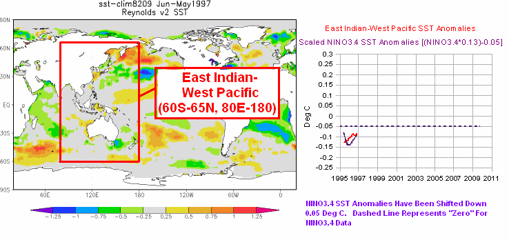
In Figure 5, I’ve added an arbitrarily scaled ENSO index to the graph (dotted purple curves) to confirm the timing of the upward steps. NINO3.4 sea surface temperature anomalies are a commonly used index for the timing, strength and duration of El Niño and La Niña events.

Figure 5
And in Figure 6, I’ve compared the West Pacific data to the sea surface temperature anomalies of two other subsets of the global oceans. The East Indian-West Pacific data was the first subset of the global oceans where I reported on the upward steps. That was more than 5 years ago. See the posts “Can El Niño Events Explain all of the Global Warming Since 1976?” Part 1 and Part 2. (The WattsUpWithThat cross posts are here and here for those who want to review the comments.) I later expanded the region where the sea surface temperature data show the upward shifts to include the South Atlantic, Indian and West Pacific Oceans, which is also shown in Figure 6. (See the map here for the location and scale of that subset.) The South Atlantic, Indian and West Pacific subset covers more than 50% of the surface of the global oceans. All three subsets of the global oceans show the same basic El Niño-caused upward shifts, and that makes sense since they share common data.

Figure 6
THE EL NIÑO-LA NIÑA PROCESSES THAT CAUSE THE UPWARD STEPS
The following is a very brief description of how the upward steps are created. An El Niño event releases a colossal volume of warm water from the surface and, more importantly, from below the surface of the western tropical Pacific and spreads that warm water across the surface of the eastern tropical Pacific. In the cases of the 1997/98 El Niño and the 1987/88 portion of the 1986/87/88 El Niño, that warm water spread east as far as the west coast of the Americas. The El Niño does not “consume” all of the warm water that had traveled east, so after the El Niño peaks and the trades winds resume, the trade winds push the leftover warm surface water back to the West Pacific. And there is another phenomenon called a slow-moving Rossby wave that returns the leftover subsurface warm waters to the West Pacific. Ocean currents carry all of the leftover warm water poleward creating the C-shaped warming pattern in the Pacific…and into the Indian Ocean.
In the animation of sea level anomalies here (Animation 3-1 for my ebook Who Turned on the Heat?), an example of a slow moving Rossby Wave can be seen carrying leftover subsurface warm water, from east to west, at about 10N, following the 1997/98 El Niño.
Simply put, before the El Niño there was a huge amount of warm water stored below surface of the western tropical Pacific. While it was below the surface, it was excluded from the surface temperature record. During and after the El Niño, that warm water is now on the surface, raising the sea surface temperature of the global oceans (and raising land surface air temperatures in response). On the threads of blog posts over the years, the upward steps have been described by some persons as a ratcheting effect.
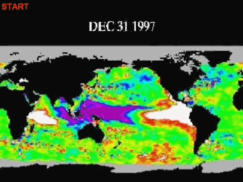
WATCH AN UPWARD SHIFT TAKE PLACE AND THE C-SHAPED WARMING PATTERN FORM
I created and collected a number of animations of the 1997/98 El Niño and its aftereffects for my ebook Who Turned on the Heat?. They are linked to and discussed in the blog post Animations Discussed in “Who Turned on the Heat?”.
Animation 6.1 presents a series of sea surface temperature anomaly maps before, during and after the 1997/98 El Niño. I’ve used maps of 12-month average sea surface temperature anomalies to minimize weather noise and the seasonal cycle in the data. Also included in the animation is a comparison graph that infills as the animation progresses. One of the datasets is a scaled ENSO index (NINO3.4 sea surface temperature anomalies) to show the timing of the 1997/98 El Niño and the trailing 1998-01 La Niña. The other dataset in the graph is the sea surface temperature anomalies of the East Indian and West Pacific Oceans. Also see Figure 6 above. So you can watch the upward shift take place in the East Indian and West Pacific data and also watch the C-shaped warming pattern form.
ADDITIONAL READING
If the subject of long-term aftereffects of El Niño events is new to you, refer to the illustrated essay The Manmade Global Warming Challenge (42MB). It includes additional discussions of the upward shifts (the Trenberth “big jumps”) in sea surface temperatures.
In 2012, I published my e-book about the phenomena called El Niño and La Niña. It’s titled Who Turned on the Heat? with the subtitle The Unsuspected Global Warming Culprit, El Niño Southern Oscillation. It is intended for persons (with or without technical backgrounds) interested in learning about El Niño and La Niña processes and in understanding the natural causes of the warming of our global oceans for the past 30 years. It presents how the sea surface temperature data and ocean heat content data account for their warming—and there are no indications the warming was caused by manmade greenhouse gases. None at all.
Who Turned on the Heat? was introduced in the blog post Everything You Ever Wanted to Know about El Niño and La Niña……Well Just about Everything. The Free Preview includes the Table of Contents; the Introduction; the beginning of Section 1, with the cartoon-like illustrations; the discussion About the Cover; and the Closing.
Please buy a copy. (Paypal or Credit/Debit Card). You do not need to have a PayPal account. Simply scroll down to the “Don’t Have a PayPal Account” purchase option. It’s now sale priced at US$5.00.
SOURCES
The satellite-enhanced Reynolds OI.v2 sea surface temperature anomaly data used in this post is available through the NOAA NOMADS website. The trend maps were created at, and the ERSST.v3b and HADISST sea surface temperature data, are available through the KNMI Climate Explorer.
Jeff says, “Isn’t it likely that these steps will now REVERSE and each successive el nino, or at least big el nino events (such as 1983, 1988 and 1997) will bring about more cooler SST temperatures and, thus, earth temperatures?”
Since the PDO is an aftereffect of ENSO (with an additional impact of the sea level pressure and corresponding wind patterns of the North Pacific impacting the PDO), I suspect that the PDO will switch modes in response to the upcoming El Niño…IF, BIG IF, the El Niño is a strong east Pacific El Niño. The PDO was slightly positive in January and February, BTW:
http://jisao.washington.edu/pdo/PDO.latest
Also, I know of no process through which an El Niño could cause global sea surface temperatures and global combined land+sea surface temperatures to cool, especially when we consider ENSO acts as a recharge-discharge oscillator. It is soon going to release a lot of heat into the atmosphere, and redistribute a lot of leftover warm water in its wake.
The question now is, will it be strong East Pacific El Nino?
“Sounds to me as though you’re entering the coordinates wrong. ”
possible !
What coords do I need to put into NOMADS to get NINO3.4 ? The default values are -180 , 180 which I take to indicate the range, so it’s not clear how to span from 170E to 240E.
Thanks.
“Also, I know of no process through which an El Niño could cause global sea surface temperatures and global combined land+sea surface temperatures to cool”
If you are correct that Ninjo/Ninja is pumping up global temps I would have expected that reduced frequency and amplitude of ENSO variability will simply allow to Earth to cool. That seems to be happening since 2005 , though the process probably started before that.
Greg Goodman: It’s easier to show you.
NINO3.4:
http://bobtisdale.files.wordpress.com/2014/04/nomads-inputs-for-nino3-4-data.png
East Indian-West Pacific:
http://bobtisdale.files.wordpress.com/2014/04/nomads-inputs-for-east-indian-west-pacific.png
Regards
Greg Goodman: For that graph in the animation, I also scaled (multiplied) the NINO3.4 data by a factor of 0.13 and smoothed both datasets with 12-month running mean filters to agree with the maps that presented 12-month averages.
Regards
Greg Goodman says: “If you are correct that Ninjo/Ninja is pumping up global temps I would have expected that reduced frequency and amplitude of ENSO variability will simply allow to Earth to cool. That seems to be happening since 2005 , though the process probably started before that.”
The sea surface temperatures for the East Indian-West Pacific data, and for the South Atlantic-Indian-West Pacific data actually cool slightly between the 1986/87/88 and 1997/98 El Ninos and between the 1997/98 and 2009/10 El Ninos.
Regards
Thanks Mr. Tisdale! So our collective scrutiny of ocean atmosphere behavior is too short a time to see even a full cycle of heating up then cooling off. The near future promises very revealing data sets ! I think it very cool should we see a true step down in ocean temps as the record lengthens.
For those reading the thread who are looking for a more detailed response from me to lgl’s comment about La Niñas, see the discussion under the heading THE ENERGY SOURCE THAT FUELS ENSO-RELATED WARMING in the post here:
http://bobtisdale.wordpress.com/2013/01/25/untruths-falsehoods-fabrications-misrepresentations/
Bob Tisdale says:
April 6, 2014 at 4:22 pm
Greg Goodman: For that graph in the animation, I also scaled (multiplied) the NINO3.4 data by a factor of 0.13 and smoothed both datasets with 12-month running mean filters to agree with the maps that presented 12-month averages.
Regards
Ah-ha. I new there was something you were forgetting to tell us, that’s why I asked about scaling.
I’d scaled it by 6 which is not too far different.
I gets interesting when you lag it , which is why I got into this when I saw you gif.
A 9 month lag lines up a lot of features :
http://oi59.tinypic.com/16iif83.jpg
Now that seems to go along with what I said, small oscillations allows cooling, when if starts to have large swings it warms WPac + IO.
BTW I used a Lanczos filter to remove annual variability, that’s why it’s lot smoother than your runny mean.
Also that’s a pretty regular 1.71 year oscillation running right though there.
Greg Goodman on April 6, 2014
If you are correct that Ninjo/Ninja is pumping up global temps I would have expected that reduced frequency and amplitude of ENSO variability will simply allow to Earth to cool. That seems to be happening since 2005 , though the process probably started before that.
… Now that seems to go along with what I said, small oscillations allows cooling, when if starts to have large swings it warms WPac + IO.
I think you’ve hit on something important that I had been wondering about. It may be that the simple paradigm of “el Nino warms La Nina cools” is wrong, as Bob himself has indicated. Instead the high amplitude el Nino-la Nina cycle ratchets up ocean temps while sustained neutrality and small oscillations allow cooling.
It cant just be one way.
Bob, back in 2010, rather unfortunately April 1st (only just noticed) I showed some Hovmoller maps as I was creating code to do them. You have I believe done much the same. Nicely RSS have some too.
C shaped I call V shaped, neither quite right but the twist is that these appear globally where it is heat flowing from equator to poles, hence the north and south lines.
I did this too with a variety of long datasets. The effect is there from the 1800s and so are the “heat thumps” followed by holes, which looks to me akin to oscillatory undershoot as transients stabilise. I’ve never remarked on this because I don’t much like effect without a causal, never found a sensible reason for a heat thump which is phased correctly.
Rough idea is linked or dig out the slightly different RSS plots. Main difference is I have used a double sine to try and equalise visually out to the polar regions where temperature excursions are greater.
http://daedalearth.wordpress.com/2010/04/01/time-maps/
I was looking at the AMO data at another site and you know what I noticed? There are “steps” there as well. In fact, these “steps” correspond with the same temperature steps that occur after certain el ninos.
So I was thinking, what if these “steps” are not caused by el ninos at all (why would an el nino cause such a step?), but are rather a function of the rising AMO, and el nino/la ninas/ENSO neutral phases only serve to regulate the temperature itself in between ENSO events. If so, regardless of whether this is a super el nino or not, I seriously doubt we’ll see another “step” following it for one simple reason: the AMO has hit its peak and is likely to begin really falling soon. If there were another higher “step” after this el nino it would be unusual since it would represent the first such step recorded that didn’t occur along with a rising AMO.
I’m also going to keep an eye on what this coming el nino does to the AMO. 1) I’m curious if the el nino event will actually trigger the beginning of AMO cooling; 2) determine what connection the PDO and ENSO phases have with the AMO.
The contradiction in Trenberth’s article “Has Global Warming Stalled?” has not escaped me. He says over 90% of surface heat goes to the ocean yet still believes man is in control of global climate. He says the ocean can take away the heat from the atmosphere and cause the 15-year warming pause. If that is true then global climate is driven by natural ocean cycles. The climate is defined by surface air temperature not the ocean temperature 700 m deep.
Finally he says short-term warming may stall but at the expense of long-term warming. What is long-term? Ocean cycles like the thermohaline circulation can have a timescale of 1,000 years or more. Even the IPCC AR3 admitted equilibrium climate sensitivity (ECS) takes thousands of years to attain considering deep ocean circulations. In this viewpoint, “short-term” is centuries and “long-term” is millennia.
TimChannon says: http://daedalearth.wordpress.com/2010/04/01/time-maps/
What I’ve noted in these kind of Hovmoller maps before is not just poleward curves but full circles. It’s not a one way street. As far as I can ascertain by eye from those graphs the circle diameter (cycle length) is about 4 years.
tchannon says: “C shaped I call V shaped, neither quite right but the twist is that these appear globally where it is heat flowing from equator to poles, hence the north and south lines.”
Tim, thanks for sharing the Hovmollers.
In looking at the Hovmollers, I agree that the V-shape shows the poleward flow of heat from the tropics after an El Nino. They also confirm that La Ninas do not have the same impacts as El Ninos. Note how the warm TLT anomalies from the 1986/87/88 and 1997/98 El Ninos linger at mid-latitudes during the 1988/89 and 1998-01 La Ninas. That should be caused by the secondary release of leftover El Nino heat from the Kuroshio-Oyashio Extension (east of Japan) and the SPCZ (east of Australia and New Zealand) during those La Ninas.
With respect to the V-shapes in the Hovmollers and the C-shapes in maps in this post, keep in mind that your Hovmollers are showing anomalies, and my maps are showing trends.
Cheers
Jeff, with respect to the AMO: Keep in mind that if we detrend the satellite-era North Atlantic sea surface temperature anomalies and compare them to scaled and lagged NINO3.4 data, we can see that the North Atlantic warms during the 1986/87/88 and 1997/98 El Niños but does not cool proportionally during the trailing La Niñas. That indicates that La Niñas do not have the same impacts on the North Atlantic as the strong El Niños. So the steps in the North Atlantic/AMO (like in the other subsets such as the South Atlantic-Indian-West Pacific) result because La Niñas are not having an equal and opposing effect on the North Atlantic.
http://bobtisdale.files.wordpress.com/2014/03/figure-11.png
The graph is from this post:
http://bobtisdale.wordpress.com/2014/03/13/on-chylek-et-al-2014-the-atlantic-multidecadal-oscillation-as-a-dominant-factor-of-oceanic-influence-on-climate/
Cheers
phlogiston says:
I think you’ve hit on something important that I had been wondering about. It may be that the simple paradigm of “el Nino warms La Nina cools” is wrong, as Bob himself has indicated. Instead the high amplitude el Nino-la Nina cycle ratchets up ocean temps while sustained neutrality and small oscillations allow cooling.
It cant just be one way.
====
Yes, I’ve only seen Bob talk about the warming effect of ENSO but since the globe is not eternally warming, it can’t just be one way.
His point is that La Ninja 😉 causes more incoming solar to be captured and El Ninjo pushes it out to the atmosphere. This is NOT an “internal oscillation” as it is usually classed my mainstream climatologists/alarmists in order to dismiss it as a cause of long term variability.
This is a very sloppy attempt at science by labels. By CALLING it an oscillation, they imply some kind symmetric pendulum swing behaviour that arbitrarily ASSUMED to average out.
What Bob is pointing out is that it is NOT an oscillation, it is the throughput of external energy.
When the throughput increases, more external energy is stored in the oceans and then dumped to the atmosphere. As a result surface temps rise.
The conclusion of this view of the process is that there is some dynamic equilibrium point with an “average” ENSO activity. Periods of more ENSO cause warming, period of less than average ENSO allow cooling by simple radiative losses.
Unfortunately, I don’t think this is the end of the line. I don’t believe as the orthodoxy maintains, that ENSO has a life of its own and is its own creator. Since system evolution almost demands that everything interacts, I think that this mechanism of varying surface temps may be, at least in part, a feedback mechanism itself.
I also suspect, though have not proved, that it is partly driven by long period, subsurface tides at the thermocline, analogous to the surface tides but with periods about 1000 times longer due to the very small density difference compared to the surface air/water interface.
Bob says : “Jeff, with respect to the AMO: Keep in mind that if we detrend the satellite-era North Atlantic sea surface temperature anomalies and compare them to scaled and lagged NINO3.4 data, we can see that ….”
Bob , why on earth do you keep “detrending” stuff when trying to asses the cause of the warming trend?
What is this “trend” that you think needs to be removed? Are you trying to prove that the long term trend is AGW and that you need to remove it to evaluate the ENSO warming??
If you want to study the long term trend and its possible relation to ENSO, which seems to be your main argument, it makes no sense at all to “detrend”. Just use the data !
Unless you have a solid and incontestable reason to do otherwise, use the data as it is.
The whole “detrending” mania that is pervasive in current climatology is based on a forgone conclusion (aka assumption) that there is a long term rise caused by anthropogenic GHG which needs to be removed in order to understand the remaining “internal noise”.
Anyone wishing to objectively study the system would not being by subtracting some arbitrary mathematical function ( albeit a nice simple one ) before starting their analysis.
Detrending data before analysis is a tacit acceptance of the AGW assumption. Unless that is also your assumption I suggest you stop doing it and take the full data as it is.
would not being by => would not begin by
http://climategrog.wordpress.com/?attachment_id=912
Extending W.Pac vs Nino34 comparison a bit further back, and comparing to aerosol optical depth (indication of volcanic forcing).
Atmospheric disruption following last two eruptions seem to sync nicely with El Nino events but could be coincidental. Large ENSO variation after El Chinon, lesser after the strong Mt Pinatubo event.
To all those people asking where the cooling phase occurs and why we can’t see it in the data, and who are concerned that this hypothesis would lead to endless warming:
What you need to see is the equivalent of Bob’s set of graphs for the years 1000 to 1600, to cover the drop from the MWP to the LIA.
Unfortunately such graphs don’t seem to exist. Some of the attempts via proxies to reconstruct the pattern that I’ve found only go back to the 1500’s, so will likely only show the neutral-to-warming transition, not the cooling phase.
“The oceans can at times soak up a lot of heat. Some goes into the deep oceans where it can stay for centuries. But heat absorbed closer to the surface can easily flow back into the air. That happened in 1998, which made it one of the hottest years on record.
Trenberth says since then, the ocean has mostly been back in one of its soaking-up modes.
“They probably can’t go on much for much longer than maybe 20 years, and what happens at the end of these hiatus periods, is suddenly there’s a big jump [in temperature] up to a whole new level and you never go back to that previous level again,” he says.”
So, clear skys from solar reduction in cloud cover wouldn’t show up during the solar cycle, but during the subsequent release 20+ year release. And aGHG warming could only account for small amount of this heat (0-.4% increased downwelling radiation?).