El Niño Residuals Cause the C-Shaped Warming Pattern in the Pacific

In the recent model-data comparison of satellite-era sea surface temperature anomalies—appropriately titled Maybe the IPCC’s Modelers Should Try to Simulate Earth’s Oceans—we compared trend maps of modeled and observed sea surface temperature anomalies from 1982 to 2013. See Figure 1. The models showed a general warming of the Pacific with the highest warming rates in the tropics and in the northwest North Pacific. In the real world, the data showed a C-shaped warming pattern, with extensive warming along the Kuroshio-Oyashio Extension east of Japan and along the South Pacific Convergence Zone (SPCZ) east of Australia and New Zealand, and with little to no warming in the tropics or the Eastern Pacific. It has come to my attention that some persons believe the start and end dates are responsible for the C-shaped pattern; that is, they think the C-shaped pattern appears in the data trend map because the Reynolds OI.v2 sea surface temperature data start in an El Niño development year and end with an ENSO-neutral year (which was preceded by back-to-back La Niña events). Their assumption is wrong, of course. The warming pattern does not depend on the start and end years I’ve used for the trend maps. The warming pattern is caused by what Kevin Trenberth and others called “ENSO residual” effects in their 2002 paper The Evolution of El Niño and Global Atmospheric Surface Temperatures. It might be easier to think of El Niño residuals as leftovers from strong El Niño events.

Fig 1 - Trend Map Comparison

Figure 1

C-SHAPED SPATIAL PATTERN DOES NOT DEPEND ON THE 1982 START AND 2013 END YEARS

First, let’s confirm that the C-shaped warming pattern in the Pacific does not depend on the 1982 (El Niño development) start year and 2013 (ENSO-neutral) end year. And to do that we’ll reverse the extremes; that is, we’ll start in a year with La Niña conditions and end with El Niño. According to NOAA’s Oceanic NINO Index (ONI), 1984 began and ended in “official” La Niña conditions. Both trend maps in Figure 2 start in 1984. The 2009/10 El Niño evolved in 2009 and decayed in 2010, so I’ve presented trend maps with both 2009 and 2010 as end years: 2009 on the left and 2010 on the right. The C-shaped pattern appears in both maps. As noted earlier, starting the trend maps during an El Niño year and ending them during an ENSO-neutral year, used in the earlier post, did not cause the C-shaped spatial warming pattern in the Pacific Ocean. That pattern also exists if we start the trend map during a La Niña and end during an El Niño.

Fig 2 - Data Trend Map Comparison

Figure 2

That C-shaped warming pattern of the Pacific sea surfaces exists even if we start the trend analysis as far back as 1977. See Figure 3. That is the first year after the 1976 Climate Shift, which, as you’ll recall, raised the sea surface temperature anomalies of the East Pacific Ocean almost 0.2 deg C. I’ve presented trends from 2 sea surface temperature reconstructions for the period of 1977 to 2013 in Figure 3, NOAA’s ERSST.v3b on the left and UKMO’s HADISST on the right.

Fig 3 - Data Trend Map Comparison 1977-2013

Figure 3

EL NIÑO RESIDUALS (LEFTOVERS) CAUSE THE C-SHAPED WARMING PATTERN

We’ll return to the satellite-enhanced Reynolds OI.v2 sea surface temperature data for this part of the discussion. Figure 4 presents the sea surface temperature anomalies of the West Pacific Ocean. I’ve added a few notes to it. Since November 1981, the sea surface temperatures there warmed in two steps. The first step was in response to the 1986/87/88 El Niño and the second step was a response to the 1997/98 El Niño. After the 1997/98 El Niño, there was little to no longer-term warming there, just some year to year variations caused by the subsequent and lesser El Niño and La Niña events. Additionally, between the 1986/87/88 and 1997/98 El Niños, the sea surface temperature data for the West Pacific also show no warming. The big dip and rebound starting in 1991 is a response of the sea surface temperatures of the West Pacific Oceans to the eruption of Mount Pinatubo.

Figure 4

Figure 4

Kevin Trenberth of NCAR, who is known for his El Niño research, referred to these upward shifts in temperature as “big jumps” in his article for Royal Meteorological Society titled Has Global Warming Stalled? back in May 2013. (We discussed that article in the post Open Letter to the Royal Meteorological Society Regarding Dr. Trenberth’s Article “Has Global Warming Stalled?”.) Since then, Trenberth has confirmed strong El Niño events are responsible for the “big jumps”. Trenberth discussed the “big jumps” in his August 2013 interview on NPR . “1998” is a reference to the 1997/98 El Niño, of course (my boldface):

The oceans can at times soak up a lot of heat. Some goes into the deep oceans where it can stay for centuries. But heat absorbed closer to the surface can easily flow back into the air. That happened in 1998, which made it one of the hottest years on record.

Trenberth says since then, the ocean has mostly been back in one of its soaking-up modes.

“They probably can’t go on much for much longer than maybe 20 years, and what happens at the end of these hiatus periods, is suddenly there’s a big jump [in temperature] up to a whole new level and you never go back to that previous level again,” he says.

You can think of it like a staircase. Temperature is flat when a natural cool spell cancels out the gradual temperature increase caused by human activity. But when there’s a natural warm spell on top of the long-term warming trend, the story is dramatically different.

Kevin Trenberth is obviously still trying to keep alive the notion that greenhouse gases are responsible for the warming of the global oceans.

In Figure 5, I’ve added an arbitrarily scaled ENSO index to the graph (dotted purple curves) to confirm the timing of the upward steps. NINO3.4 sea surface temperature anomalies are a commonly used index for the timing, strength and duration of El Niño and La Niña events.

Figure 5

Figure 5

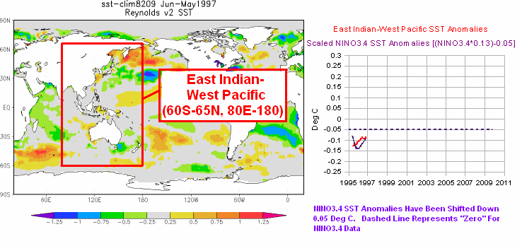
And in Figure 6, I’ve compared the West Pacific data to the sea surface temperature anomalies of two other subsets of the global oceans. The East Indian-West Pacific data was the first subset of the global oceans where I reported on the upward steps. That was more than 5 years ago. See the posts “Can El Niño Events Explain all of the Global Warming Since 1976?” Part 1 and Part 2. (The WattsUpWithThat cross posts are here and here for those who want to review the comments.) I later expanded the region where the sea surface temperature data show the upward shifts to include the South Atlantic, Indian and West Pacific Oceans, which is also shown in Figure 6. (See the map here for the location and scale of that subset.) The South Atlantic, Indian and West Pacific subset covers more than 50% of the surface of the global oceans. All three subsets of the global oceans show the same basic El Niño-caused upward shifts, and that makes sense since they share common data.

Figure 6

Figure 6

THE EL NIÑO-LA NIÑA PROCESSES THAT CAUSE THE UPWARD STEPS

The following is a very brief description of how the upward steps are created. An El Niño event releases a colossal volume of warm water from the surface and, more importantly, from below the surface of the western tropical Pacific and spreads that warm water across the surface of the eastern tropical Pacific. In the cases of the 1997/98 El Niño and the 1987/88 portion of the 1986/87/88 El Niño, that warm water spread east as far as the west coast of the Americas. The El Niño does not “consume” all of the warm water that had traveled east, so after the El Niño peaks and the trades winds resume, the trade winds push the leftover warm surface water back to the West Pacific. And there is another phenomenon called a slow-moving Rossby wave that returns the leftover subsurface warm waters to the West Pacific. Ocean currents carry all of the leftover warm water poleward creating the C-shaped warming pattern in the Pacific…and into the Indian Ocean.

In the animation of sea level anomalies here (Animation 3-1 for my ebook Who Turned on the Heat?), an example of a slow moving Rossby Wave can be seen carrying leftover subsurface warm water, from east to west, at about 10N, following the 1997/98 El Niño.

Simply put, before the El Niño there was a huge amount of warm water stored below surface of the western tropical Pacific. While it was below the surface, it was excluded from the surface temperature record. During and after the El Niño, that warm water is now on the surface, raising the sea surface temperature of the global oceans (and raising land surface air temperatures in response). On the threads of blog posts over the years, the upward steps have been described by some persons as a ratcheting effect.

WATCH AN UPWARD SHIFT TAKE PLACE AND THE C-SHAPED WARMING PATTERN FORM

I created and collected a number of animations of the 1997/98 El Niño and its aftereffects for my ebook Who Turned on the Heat?. They are linked to and discussed in the blog post Animations Discussed in “Who Turned on the Heat?”.

Animation 6.1 presents a series of sea surface temperature anomaly maps before, during and after the 1997/98 El Niño. I’ve used maps of 12-month average sea surface temperature anomalies to minimize weather noise and the seasonal cycle in the data. Also included in the animation is a comparison graph that infills as the animation progresses. One of the datasets is a scaled ENSO index (NINO3.4 sea surface temperature anomalies) to show the timing of the 1997/98 El Niño and the trailing 1998-01 La Niña. The other dataset in the graph is the sea surface temperature anomalies of the East Indian and West Pacific Oceans. Also see Figure 6 above. So you can watch the upward shift take place in the East Indian and West Pacific data and also watch the C-shaped warming pattern form.

ADDITIONAL READING

If the subject of long-term aftereffects of El Niño events is new to you, refer to the illustrated essay The Manmade Global Warming Challenge (42MB). It includes additional discussions of the upward shifts (the Trenberth “big jumps”) in sea surface temperatures.

In 2012, I published my e-book about the phenomena called El Niño and La Niña. It’s titled Who Turned on the Heat? with the subtitle The Unsuspected Global Warming Culprit, El Niño Southern Oscillation. It is intended for persons (with or without technical backgrounds) interested in learning about El Niño and La Niña processes and in understanding the natural causes of the warming of our global oceans for the past 30 years. It presents how the sea surface temperature data and ocean heat content data account for their warming—and there are no indications the warming was caused by manmade greenhouse gases. None at all.

Who Turned on the Heat? was introduced in the blog post Everything You Ever Wanted to Know about El Niño and La Niña……Well Just about Everything. The Free Preview includes the Table of Contents; the Introduction; the beginning of Section 1, with the cartoon-like illustrations; the discussion About the Cover; and the Closing.

Please buy a copy. (Paypal or Credit/Debit Card). You do not need to have a PayPal account. Simply scroll down to the “Don’t Have a PayPal Account” purchase option. It’s now sale priced at US$5.00.

SOURCES

The satellite-enhanced Reynolds OI.v2 sea surface temperature anomaly data used in this post is available through the NOAA NOMADS website. The trend maps were created at, and the ERSST.v3b and HADISST sea surface temperature data, are available through the KNMI Climate Explorer.

0 0 votes
Article Rating
88 Comments
Oldest
Newest Most Voted
Inline Feedbacks
View all comments
Richard111
April 6, 2014 4:51 am

Layman question: IF the middle of the oceans warmed up a tenth of a degree or so, admittedly a lot of energy, just how does that energy become focused to warm the atmosphere above by several whole degrees?

David L.
April 6, 2014 4:55 am

Richard111 on April 6, 2014 at 4:51 am
Layman question: IF the middle of the oceans warmed up a tenth of a degree or so, admittedly a lot of energy, just how does that energy become focused to warm the atmosphere above by several whole degrees?
………..
By a process know as “Maxwell’s demon”
Is a course in thermodynamics required as part of the climatology curriculum?

Ron C.
April 6, 2014 5:30 am

Thanks again Bob for your clear explanations. I am struck by your Figure 5, showing such a negative correlation between the West Pacific and Nino3.4. Do I understand correctly that while La Ninas are on in Nino3.4, the SSTs throughout West Pacific are rising (+anomalies) and vice-versa for El Ninos?

Ron C.
April 6, 2014 5:34 am

Oh,I also meant to ask you Bob about your perspective on the outlook for El Nino in 2014.

Stephen Wilde
April 6, 2014 5:48 am

Whilst accepting Bob’s description of the immediate cause for a step upwards I think one should go further if there are multiple successive such upward steps over decades or centuries.
I suggest that the reason for such long term stepping patterns, whether upward or downward, is changing solar activity levels altering global cloudiness so as to change the amount of solar energy entering the oceans.
That skews the balance between El Nino and La Nina dominance over time.
Thus, there has most likely been such upward stepping periodically since the LIA and most likely there was downward stepping from the MWP to the LIA.
Upward steps would occur from one positive phase of the Pacific Multi-decadal Oscillation during a time of increasing solar activity and from one negative phase to the next during a time of decreasing solar activity.
That proposition forms part of my New Climate Model.

RoHa
April 6, 2014 6:27 am

C shaped warming? Are we doomed yet?

ferdberple
April 6, 2014 6:27 am

David L. says:
April 6, 2014 at 4:55 am
By a process know as “Maxwell’s demon”
============
ah, we make zee joke, no?

JimS
April 6, 2014 6:29 am

C-shaped? – something like the configuration of a Zulu army in attack mode …

James Strom
April 6, 2014 7:12 am

So the ENSO process is like a staircase. The earth has been around in its current configuration, or something close, for millions of years. If only upward traffic is allowed on the staircase, we would be pretty hot by now. But we’re not, so there must be operating modes of ENSO that we haven’t observed as yet.

April 6, 2014 7:13 am

Thanks, Bob. Good explanation.
You have shed bright light on ENSO, the most notable natural phenomenon going on the Pacific and Indian Oceans that affects the whole planet.
So much more is yet to be discovered abut the way the Sun’s energy enters the Earth climate system.

herkimer
April 6, 2014 7:22 am

Bob
You have shown in past articles that the Pacific Ocean, pole to pole has a 30-35 year cycle . Surely a short term El Nino will have a different impact and development pattern if it occurs when the Pacific ocean is in the cooling mode than when it is in the warming mode and even different when it is in the transition mode from one to the other . Hence there tends to be more frequent and stronger El Ninos during the Ocean warming modes [1970-2000) and why El Ninos do not lower global atmosphere temperatures significantly during ocean cooling modes [ like 1895-1910]. Any comment?

Sweet Old Bob
April 6, 2014 7:38 am

RoHa at 6:27 am
When it becomes Pac Man….

Sue
April 6, 2014 7:39 am

The C-shaped warming pattern found in the observed data corresponds to the pattern of tectonic plates. See http://hisz.rsoe.hu/alertmap/index2.php for maps of the world that shows the plate boundaries and can be zoomed down to see the ocean floor. As the days go by, you’ll see icons denoting volcanic activity, earthquakes, and various other phenomena (the website is actually designed to show all kinds of disasters, natural and man-made) over the entire map. I propose that the C-shaped warming pattern is due to lava eruptions and mild volcanic activity. Such natural actions would make the water extremely hot in the immediate vicinity of the lava. As the heat travels toward the surface, the water temperature gradually warms up compared to ambient, the plume of heat cools down, and the formerly hot water is dispersed over a very wide area due to ocean currents and atmospheric winds. It seems reasonable to me that by the time the plume has reached the sea surface, the water over a very wide area could become warmer by 0.2 degrees C. Also remember that lava eruptions and mild volcanic activity each occur in a very small vicinity, but that many such spots occur over the course of a short time period (e.g., a day) and could therefore cause a gradual warming at the sea surface.

lgl
April 6, 2014 8:08 am

Again, this falls in the not-even-wrong category.
Your “residuals” is a direct result of more solar input to most of the tropics except eastern Pacific during El-Ninos.
virakkraft.com/Nomad-SWsfc-clouds-ENSO.pptx

a p
April 6, 2014 8:23 am

There are too many variables and too many unknowns for computer models didn’t you read about this problem?

trafamadore
April 6, 2014 8:27 am

“HE EL NIÑO-LA NIÑA PROCESSES THAT CAUSE THE UPWARD STEPS”
You know Bob that if you have a sin pattern (wave like) and superimpose it on a positive rise over time, it would look like a series of steps.

lgl
April 6, 2014 8:44 am

Bob
We have discussed your flawed “theory” about La-Ninas warming the ocean several times.

Arno Arrak
April 6, 2014 9:02 am

Bob, I have no idea where your temperature data come from but they have no relation to reality. Get yourself some decent UAH and RSS satellite data and dump this junk you are using. There is no such thing as a step rise in the eighties and nineties. There is a step rise right after the super El Nino that raises global temperature by a third of a degree in only three years and then stops. That is why all twenty-first century temperatures are higher than twentieth, not because of ongoing warming as Hansen tries to sell you. There are five El Nino peaks in the eighties and nineties with slight random variations whose centers of gravity line up in a horizontal straight line from 1979 to early 1997. This defines the temperature trend, not your imagined boxes. The super El Nino is twice as high as these El,Ninos are but in your data you do not even notice its existence. It gets worse in the twenty-first century where the beginning of the high at 2002 is exaggerated but the La Nina of 2008 and the El Nino of 2010 have been demoted to unidentifiable squiggles. Plus, that so called “impact of eruption of Mount Pinatubo” is nothing more exotic than an ordinary La Nina. I suggest you give up using that 13 month filter and start using a transparent magic marker instead. Or Photoshop layers. Eruptions of stratovolcanoes do not cause volcanic cooling in the troposphere: their hot gases go straight into the stratosphere. Cooling follows in about two years after the eruption but it stays up there and never reaches ground level. I suggest you educate yourself in these matters. Its easy: just read my book with comprehension.

lgl
April 6, 2014 9:05 am

… and yes, it takes a while for the absorbed solar input to reach the surface so yes, it is out of phase and should be.

Matt Souders
April 6, 2014 9:54 am

Bob, this may be a stupid question…but if the climate were in an equilibrium state, what would the force be that drives the ocean back to a neutral temperature? In other words…why doesn’t the El Nino ratchet cause the ocean to spiral off into ever increasing levels of warmth?
It seems that Trenberth thinks you are correct about the ratchet effect on temperature…but thinks the general warming of the global oceans that leads to the increasing warmth of those subsurface warm waters that fuel an El Nino warming period is caused by AGW. What is your counter-argument to this theory?

Joel O'Bryan
April 6, 2014 10:42 am

two considerations of immense import are missing in Bob’s discussion of his analysis.
1) the importance of water vapor in the lower troposphere that feeds convection and thus vapoor into the stratosphere. (water vapor is the most potent GHG). A further figure on down-welling IR with fig 5 might provide the right segue into that meld. These individual phenomenon working in concert provide feedback may allow the emergent property of climate control to operate (homeostasis in the presence of perturbations).
2) the period 1960- 2002 is a period of steadily increasing solar maximums. The Earth’s climate and ocean systems are integrating that rising input during the analyzed 1980-2010 period here by Bob in the ENSO and SST data. We are now possibly on a downward solar activity that may lead to a Grand Minimum lasting 50-200+ years. 50 years from now a heat releasing super El Nino may be a creature of distant history. But even if we see a major cooldown by 2050, I’m confident homeostasis maintaining processes will adapt.

george e. conant
April 6, 2014 11:07 am

I have a question, these el nino and la nina events do have a known cycle through the centuries, and those big step ups can’t possibly be the only direction otherwise we would have boiling oceans long ago. The question is do we have records of big step downs ?

herkimer
April 6, 2014 11:44 am

Bob
Are you you saying that deep ocean currents have no effect on ocean surface temperatures ?. Suggest you read material of Prof Wm Gray as well. Just look at the period from 1870-1910 . when ocean temperatures dropped despite the many El Ninos.

Greg Goodman
April 6, 2014 12:46 pm

http://climategrog.wordpress.com/?attachment_id=902
It’s interesting to compare figure 4 to this graph of the effect of the two major eruptions on the stratosphere. This initial effect is a warming ( aerosols blocking incoming solar causing a warming of the stratosphere). Once the aerosols have mostly been washed out the stratosphere taken on a set drop in temperature. In each case almost exactly 0.5K cooler than the level before the eruption.
It seems that the stratosphere gets ‘cleaned’ of something ( probably mainly ozone ) that leaves it more transparent and trapping less solar. The implication being that more energy makes it to the lower atmosphere.
If we look at figure 4 it seems that , though less clearly defined due to other variability, there is a surface warming that mirrors the stratospheric cooling.
The clichéd explanation is that volcanoes cause cooling but the evidence, beyond the two or three years of the initial impact, points to the opposite effect . It is clear that at least in the stratosphere there is a durable long term offset that is clearly attributable to the eruptions.
It looks like about 0.1K increase each time in SST.
It would seem unlikely that there is not a corresponding effect in the lower atmosphere, unless the climate system has very strong negative feedbacks that render it totally immune to changes in radiative forcing. Even a notable negative feedback would require some rise in temperature to drive the feedback response.
But that can’t be happening because, as we all know, the climate feedbacks are net positive and multiply any changes by a factor of about three. Don’t they??

Greg Goodman
April 6, 2014 12:49 pm

lgl says: … and yes, it takes a while for the absorbed solar input to reach the surface so yes, it is out of phase and should be.
Like this you mean?
http://climategrog.files.wordpress.com/2014/03/tropical-feedback_resp-fcos.png?w=814

pochas
April 6, 2014 1:01 pm

There’s an article on HockeySchtick that claims that El Niño’s are set off at the beginning of solar cycles. Always a skeptic, I plotted recent data and took a look. Sure enough, at the beginning of Cycles 23 and 24 an El Niño took place followd by a La Niña, and one of the El Niños was the Super-El Niño of 1998. Strong solar cycles set off strong El Niño’s, and it takes time along with weaker cycles to dissipate the retained heat. Of course the PDO and time-of-year also seem to influence the ENSO cycle.
The Article
http://hockeyschtick.blogspot.com/2014/04/studies-find-el-ninos-can-be-predicted.html
My plot (vertical scale is arbitrary)
http://i279.photobucket.com/albums/kk145/pochas_2008/SolarActivityandENSO.png

Joel O'Bryan
April 6, 2014 1:03 pm

Matt Zouders wrote, “why doesn’t the El Nino ratchet cause the ocean to spiral off into ever increasing levels of warmth?”
Those continent size areas of warmer surface waters moving outward east, then north and south, bring with them enormous water vapor convective potential. As the El Nino wanes they spread out north and south to hemisperic ITZCs. Massive convective activity is a negative feedback response, both transporting and transferring the latent heat through the evaporation-condensation cycle. Of course the clouds associated with all this tropospheric water vapor also substantially slows surface heating from incident solar irradiation and increases albedo. All these processes are coupled and separating (de-convolving) one from the other leads to the likely erroneous outputs due to the current models’ inabilities to correctly simulate all these interactions. Clouds, both their creation and effects, have frequently been cited as one of the modelers’s main uncertainties.

Joel O'Bryan
April 6, 2014 1:04 pm

Matt Souders, sorry, not Zouders.

MikeTheDenier
April 6, 2014 1:35 pm

C shaped. Hmmmm. I bet it tastes like chicken too.

Greg Goodman
April 6, 2014 1:52 pm

Quick lash-up graph of inverted SST and TLS
http://oi57.tinypic.com/vubeh.jpg
Not surprisingly, oceans take a while longer to react, but it looks to be the same step behaviour.

Greg Goodman
April 6, 2014 2:35 pm

“If memory serves, the relationship falls apart before the 1970s.”
If you just take two ten year events like that Pochas, you could conclude that volcanoes are linked to solar cycles. too.

April 6, 2014 2:51 pm

Joe Bastardi has an interesting idea about the oncoming El Nino. Whereas prior events were caused by conditions in the ocean itself, and thus able to perpetuate growth, Joe suggests the current event is caused by conditions over the landmass of Asia generating winds favorable to El Nino formation. Because conditions over inland Asia change so drastically from winter to summer, the “favorable” conditions will abruptly become “unfavorable,” resulting in the El Nino abruptly terminating, despite the fact it will start out like gang-busters. (Or that’s how I understood the idea; I could have it screwed up.)
It will be interesting to watch this event, to see if this El Nino behaves differently because the PDO is “cold.”

Jeff
April 6, 2014 3:13 pm

Is it possible Bob, now that Kevin’s opinion is incomplete. He assumes that these el ninos cause upward steps and this has definitely been true since 1976, but el ninos and these steps are not new. CO2 doesn’t cause these steps. This phenomenon has likely been going on as long as we have had oceans (at the very least since the continents became landlocked 2.5 million years ago creating the Atlantic and Pacific oceans we know today).
My point is that these steps occurred during a long-term warm PDO phase. Now that this phase has gone cool. Isn’t it likely that these steps will now REVERSE and each successive el nino, or at least big el nino events (such as 1983, 1988 and 1997) will bring about more cooler SST temperatures and, thus, earth temperatures?

Greg Goodman
April 6, 2014 3:14 pm

Bob your animation looked interesting , so I tried to reproduce it .
http://bobtisdale.files.wordpress.com/2012/02/east-indian-west-pacific-97-thru-012.gif
I don’t find anything like what you showed in the graph. The range variability in NINO34. is less than a degree, in the 80,180E, -60,60N zone it about three degrees.
Did you scale or normalise or something?

Greg Goodman
April 6, 2014 4:03 pm

“Sounds to me as though you’re entering the coordinates wrong. ”
possible !
What coords do I need to put into NOMADS to get NINO3.4 ? The default values are -180 , 180 which I take to indicate the range, so it’s not clear how to span from 170E to 240E.
Thanks.

Greg Goodman
April 6, 2014 4:12 pm

“Also, I know of no process through which an El Niño could cause global sea surface temperatures and global combined land+sea surface temperatures to cool”
If you are correct that Ninjo/Ninja is pumping up global temps I would have expected that reduced frequency and amplitude of ENSO variability will simply allow to Earth to cool. That seems to be happening since 2005 , though the process probably started before that.

george e. conant
April 6, 2014 4:30 pm

Thanks Mr. Tisdale! So our collective scrutiny of ocean atmosphere behavior is too short a time to see even a full cycle of heating up then cooling off. The near future promises very revealing data sets ! I think it very cool should we see a true step down in ocean temps as the record lengthens.

Greg Goodman
April 6, 2014 5:08 pm

Bob Tisdale says:
April 6, 2014 at 4:22 pm
Greg Goodman: For that graph in the animation, I also scaled (multiplied) the NINO3.4 data by a factor of 0.13 and smoothed both datasets with 12-month running mean filters to agree with the maps that presented 12-month averages.
Regards
Ah-ha. I new there was something you were forgetting to tell us, that’s why I asked about scaling.
I’d scaled it by 6 which is not too far different.
I gets interesting when you lag it , which is why I got into this when I saw you gif.
A 9 month lag lines up a lot of features :
http://oi59.tinypic.com/16iif83.jpg
Now that seems to go along with what I said, small oscillations allows cooling, when if starts to have large swings it warms WPac + IO.

Greg Goodman
April 6, 2014 5:27 pm

BTW I used a Lanczos filter to remove annual variability, that’s why it’s lot smoother than your runny mean.
Also that’s a pretty regular 1.71 year oscillation running right though there.

phlogiston
April 6, 2014 6:30 pm

Greg Goodman on April 6, 2014
If you are correct that Ninjo/Ninja is pumping up global temps I would have expected that reduced frequency and amplitude of ENSO variability will simply allow to Earth to cool. That seems to be happening since 2005 , though the process probably started before that.
… Now that seems to go along with what I said, small oscillations allows cooling, when if starts to have large swings it warms WPac + IO.

I think you’ve hit on something important that I had been wondering about. It may be that the simple paradigm of “el Nino warms La Nina cools” is wrong, as Bob himself has indicated. Instead the high amplitude el Nino-la Nina cycle ratchets up ocean temps while sustained neutrality and small oscillations allow cooling.
It cant just be one way.

April 6, 2014 6:40 pm

Bob, back in 2010, rather unfortunately April 1st (only just noticed) I showed some Hovmoller maps as I was creating code to do them. You have I believe done much the same. Nicely RSS have some too.
C shaped I call V shaped, neither quite right but the twist is that these appear globally where it is heat flowing from equator to poles, hence the north and south lines.
I did this too with a variety of long datasets. The effect is there from the 1800s and so are the “heat thumps” followed by holes, which looks to me akin to oscillatory undershoot as transients stabilise. I’ve never remarked on this because I don’t much like effect without a causal, never found a sensible reason for a heat thump which is phased correctly.
Rough idea is linked or dig out the slightly different RSS plots. Main difference is I have used a double sine to try and equalise visually out to the polar regions where temperature excursions are greater.
http://daedalearth.wordpress.com/2010/04/01/time-maps/

Jeff
April 6, 2014 8:21 pm

I was looking at the AMO data at another site and you know what I noticed? There are “steps” there as well. In fact, these “steps” correspond with the same temperature steps that occur after certain el ninos.
So I was thinking, what if these “steps” are not caused by el ninos at all (why would an el nino cause such a step?), but are rather a function of the rising AMO, and el nino/la ninas/ENSO neutral phases only serve to regulate the temperature itself in between ENSO events. If so, regardless of whether this is a super el nino or not, I seriously doubt we’ll see another “step” following it for one simple reason: the AMO has hit its peak and is likely to begin really falling soon. If there were another higher “step” after this el nino it would be unusual since it would represent the first such step recorded that didn’t occur along with a rising AMO.

Jeff
April 6, 2014 8:27 pm

I’m also going to keep an eye on what this coming el nino does to the AMO. 1) I’m curious if the el nino event will actually trigger the beginning of AMO cooling; 2) determine what connection the PDO and ENSO phases have with the AMO.

Dr. Strangelove
April 6, 2014 8:40 pm

The contradiction in Trenberth’s article “Has Global Warming Stalled?” has not escaped me. He says over 90% of surface heat goes to the ocean yet still believes man is in control of global climate. He says the ocean can take away the heat from the atmosphere and cause the 15-year warming pause. If that is true then global climate is driven by natural ocean cycles. The climate is defined by surface air temperature not the ocean temperature 700 m deep.
Finally he says short-term warming may stall but at the expense of long-term warming. What is long-term? Ocean cycles like the thermohaline circulation can have a timescale of 1,000 years or more. Even the IPCC AR3 admitted equilibrium climate sensitivity (ECS) takes thousands of years to attain considering deep ocean circulations. In this viewpoint, “short-term” is centuries and “long-term” is millennia.

Greg Goodman
April 7, 2014 1:13 am

TimChannon says: http://daedalearth.wordpress.com/2010/04/01/time-maps/
What I’ve noted in these kind of Hovmoller maps before is not just poleward curves but full circles. It’s not a one way street. As far as I can ascertain by eye from those graphs the circle diameter (cycle length) is about 4 years.

Greg Goodman
April 7, 2014 2:13 am

phlogiston says:
I think you’ve hit on something important that I had been wondering about. It may be that the simple paradigm of “el Nino warms La Nina cools” is wrong, as Bob himself has indicated. Instead the high amplitude el Nino-la Nina cycle ratchets up ocean temps while sustained neutrality and small oscillations allow cooling.
It cant just be one way.
====
Yes, I’ve only seen Bob talk about the warming effect of ENSO but since the globe is not eternally warming, it can’t just be one way.
His point is that La Ninja 😉 causes more incoming solar to be captured and El Ninjo pushes it out to the atmosphere. This is NOT an “internal oscillation” as it is usually classed my mainstream climatologists/alarmists in order to dismiss it as a cause of long term variability.
This is a very sloppy attempt at science by labels. By CALLING it an oscillation, they imply some kind symmetric pendulum swing behaviour that arbitrarily ASSUMED to average out.
What Bob is pointing out is that it is NOT an oscillation, it is the throughput of external energy.
When the throughput increases, more external energy is stored in the oceans and then dumped to the atmosphere. As a result surface temps rise.
The conclusion of this view of the process is that there is some dynamic equilibrium point with an “average” ENSO activity. Periods of more ENSO cause warming, period of less than average ENSO allow cooling by simple radiative losses.
Unfortunately, I don’t think this is the end of the line. I don’t believe as the orthodoxy maintains, that ENSO has a life of its own and is its own creator. Since system evolution almost demands that everything interacts, I think that this mechanism of varying surface temps may be, at least in part, a feedback mechanism itself.
I also suspect, though have not proved, that it is partly driven by long period, subsurface tides at the thermocline, analogous to the surface tides but with periods about 1000 times longer due to the very small density difference compared to the surface air/water interface.

Greg Goodman
April 7, 2014 2:21 am

Bob says : “Jeff, with respect to the AMO: Keep in mind that if we detrend the satellite-era North Atlantic sea surface temperature anomalies and compare them to scaled and lagged NINO3.4 data, we can see that ….”
Bob , why on earth do you keep “detrending” stuff when trying to asses the cause of the warming trend?
What is this “trend” that you think needs to be removed? Are you trying to prove that the long term trend is AGW and that you need to remove it to evaluate the ENSO warming??
If you want to study the long term trend and its possible relation to ENSO, which seems to be your main argument, it makes no sense at all to “detrend”. Just use the data !
Unless you have a solid and incontestable reason to do otherwise, use the data as it is.

Greg Goodman
April 7, 2014 2:32 am

The whole “detrending” mania that is pervasive in current climatology is based on a forgone conclusion (aka assumption) that there is a long term rise caused by anthropogenic GHG which needs to be removed in order to understand the remaining “internal noise”.
Anyone wishing to objectively study the system would not being by subtracting some arbitrary mathematical function ( albeit a nice simple one ) before starting their analysis.
Detrending data before analysis is a tacit acceptance of the AGW assumption. Unless that is also your assumption I suggest you stop doing it and take the full data as it is.

Greg Goodman
April 7, 2014 2:47 am

would not being by => would not begin by

Greg Goodman
April 7, 2014 3:21 am

http://climategrog.wordpress.com/?attachment_id=912
Extending W.Pac vs Nino34 comparison a bit further back, and comparing to aerosol optical depth (indication of volcanic forcing).
Atmospheric disruption following last two eruptions seem to sync nicely with El Nino events but could be coincidental. Large ENSO variation after El Chinon, lesser after the strong Mt Pinatubo event.

steveta_uk
April 7, 2014 3:49 am

To all those people asking where the cooling phase occurs and why we can’t see it in the data, and who are concerned that this hypothesis would lead to endless warming:
What you need to see is the equivalent of Bob’s set of graphs for the years 1000 to 1600, to cover the drop from the MWP to the LIA.
Unfortunately such graphs don’t seem to exist. Some of the attempts via proxies to reconstruct the pattern that I’ve found only go back to the 1500’s, so will likely only show the neutral-to-warming transition, not the cooling phase.

aaron
April 7, 2014 4:47 am

“The oceans can at times soak up a lot of heat. Some goes into the deep oceans where it can stay for centuries. But heat absorbed closer to the surface can easily flow back into the air. That happened in 1998, which made it one of the hottest years on record.
Trenberth says since then, the ocean has mostly been back in one of its soaking-up modes.
“They probably can’t go on much for much longer than maybe 20 years, and what happens at the end of these hiatus periods, is suddenly there’s a big jump [in temperature] up to a whole new level and you never go back to that previous level again,” he says.”
So, clear skys from solar reduction in cloud cover wouldn’t show up during the solar cycle, but during the subsequent release 20+ year release. And aGHG warming could only account for small amount of this heat (0-.4% increased downwelling radiation?).

lgl
April 7, 2014 6:45 am

Bob
you have never presented anything that contradicts my findings.
I just did. There is a good correlation between solar input to “the rest of the world” tropics, excluding eastern Pacific, and LW up at TOA over the same regions (and globally lagged), so obviously it was the reduced cloud cover over most of the tropics during the 97-98 Nino that warmed the world and not the tiny 95-Nina. I have asked before, why didn’t much stronger Ninas warm the world even more than the tiny 95-Nina?

April 7, 2014 7:56 am

“In the real world, the data showed a C-shaped warming pattern,”
Just what I saw in the multi-year SST animations after El Nino events, warmth residuals persisting in the mid latitudes. Good post.

lgl
April 7, 2014 8:41 am

and Bob,
What ‘fueled’ the 83 Mega-Nino? The huge 82-Nina? oops that was no Nina at all, must have been the 75-76 Nina then, and the warm water hiding in western Pacific for 6 years?

April 7, 2014 3:55 pm

Bob Tisdale says:
April 6, 2014 at 3:40 pm
“The AMO may have—repeat, may have—peaked,”
Judging by what happened during the weaker solar cycles in the 1880/90’s I would say that the generally positive AMO phase has quite a way to go yet.

george e. conant
April 7, 2014 5:06 pm

I had mentioned el nino / la nina events were known about for centuries, I meant that as broad understandings by sea familiar peoples as well as our modern civilizations general knowledge. I am thinking the earth’s climate stubborn stability (ECSS) as evidenced we are still here and talking about it … This planets fine tuning for life is down right awesome, rotation speed of earth at the equator about 1,000 mph. Equatorial circumference about 24, 500 miles, 23 degree tilt of its axis from ecliptic plane , and on and on with astronomical precisions of our solar system. The energy input and energy output on earth seems a finely tuned oscillating chaotic living thing. So surely we can measure heat in and heat subtraction out. If this is possible, then the GHG thermal capacity must either show up or fail to trap heat. In effect there must be a detectable thermal blanket or insulating effect of guilty gasses. I remember seeing press that the earth’s atmosphere would become an acidic planetary cloud cover making it as hot as Venus (just like Venus) etc. They called it “Run away Global Warming” and words like tipping point were in such reports. So with great excitement I am fascinated with the idea of a step down, probably after a leveling off or plateau, then bump down, with the pattern emerging probably dependent on solar cycles. THEN with god knows how many ppm (pick your evil gas) and a demonstration of minni-iceage to drive the point home, you know what “they” will say….. See! We Told you it would be Catastrophic Climate Change!!! Not a word about global warming will be uttered in this possible future!

Jeff
April 7, 2014 7:07 pm

The AMO fell again in March to its lowest value in almost five years — It’s now neg (-) 0.058. Third month in a row, each month successively lower than last.
I wonder if a building el nino makes the AMO negative temporarily. You see the same thing in 2010 and before the 1997, 2007 and 2003 el ninos.

Jeff
April 7, 2014 7:11 pm

Also anyone else keeping an eye on the SOI (Southern Oscillation Index)? When it’s negative it usually means el nino and it had been collapsing in Feb and March. It averaged -12.0 in March (it was -1.2 in Feb, positive in January). But since beginning of April it’s been SURGING. It was +9.9 last week and today it is at +11.2).

lgl
April 8, 2014 7:34 am

Bob,
Thanks for your effort but as you have seen I’m focusing on the tropics, because that’s where most of the heat is generated and the signals are much cleaner (clearer). But your fig.2 is good. Shift it one year and you’ve got it. http://virakkraft.com/Bob.png (I have cut it in 95 because of Pinatubo and the trend)

lgl
April 9, 2014 7:14 am

Bob
You should waste some more time, to learn a bit about impulse response. The large Ninos are energy impulses (they take a year to peak but climatically that’s an impulse). Take a look at slide 22 here: http://www.princeton.edu/~cuff/ele301/files/lecture3_2.pdf and see what happens when the impulses get more frequent.
I have added a couple of slides to my ppt to put it in Nino context. http://virakkraft.com/Nomad-SWsfc-clouds-ENSO.pptx
See, I didn’t miss the shifts, just focusing on the energy input, not the response.