Essay by Eric Worrall
In 2014 NOAA blamed record high sea ice on global warming. Now NSIDC blames record low sea ice on global warming.
World’s sea-ice falls to record low
Mark Poynting and Erwan Rivault
BBC Climate & Verify data journalism teams
The world’s frozen oceans, which help to keep the planet cool, currently have less ice than ever previously recorded, satellite data shows.
Sea-ice around the north and south poles acts like a giant mirror by reflecting much of the Sun’s energy back into space.
But as rising temperatures cause this bright layer to shrink, the dark ocean below can absorb more heat, warming the planet further.
This latest sea-ice low appears to have been driven by a combination of warm air, warm seas and winds breaking apart the ice.
…
“Every year, every data point that we get suggests that this isn’t a temporary shift, but something more permanent, like what we’ve seen in the Arctic,” Walter Meier, senior research scientist at NSIDC, told BBC News.
“It is indicating that the Antarctic has moved into a new regime of lower ice extents.“
…
Read more: https://www.bbc.com/news/articles/cvgeydkz08go
Back in 2014, melting glaciers making sea water less saline was blamed for record HIGH Antarctic sea ice.
Antarctic winter sea ice extent sets new record in 2014
BY MICHON SCOTT REVIEWED BY TED SCAMBOS
PUBLISHED OCTOBER 7, 2014DETAILS
…
It’s not unreasonable to wonder how, if the planet is warming, Antarctic winter sea ice can set record highs. As the NSIDC release explains, Antarctica’s sea ice growth spurt may be down to stronger winds and slightly fresher sea surface water around the margins of the continent’s melting ice shelves.
…
Winds probably did not act alone to spur so much sea ice growth; melting land ice may have played a role. Most of Antarctica’s ice lies in the ice sheets that cover the continent, and in recent decades, that ice has been melting. Along the coastline, ice shelves float on the ocean surface, and much of the recent melt may be driven by warm water from the deep ocean rising and making contact with ice shelf undersides.
How does the melting of land ice matter to sea ice formation? The resulting meltwater is fresher than the seawater. As it mixes with the seawater, the meltwater makes the nearby seawater slightly less dense, and slightly closer to the freezing point than the ocean water below. This less dense seawater spreads out across the ocean surface surrounding the continent, forming a stable pool of surface water that is close to the freezing point, and close to the ice onto which it could freeze.
So as counterintuitive as expanding winter Antarctic sea ice may appear on a warming planet, it may actually be a manifestation of recent warming. “Both the Arctic and the Antarctic are responding to climate change, and both have areas that are warming rapidly,” explains NSIDC lead scientist Ted Scambos. “But Antarctic sea ice is responding to wind shifts and ocean changes in an unexpected way, and we’re still trying to fully understand it.”
References:
Melting in the North, freezing in the South
Read more: https://www.climate.gov/news-features/featured-images/antarctic-winter-sea-ice-extent-sets-new-record-2014
Sea Ice scientists should come clean and admit they have no idea which direction sea ice will move next, instead of placing an each way bet, and blaming any change on global warming.
There is plenty of evidence Antarctic sea ice has varied wildly for at least the last century.
In 2013, the “Spirit of Mawson” Ship of Fools expedition got stuck in sea ice, while trying to relive a small part of Mawson’s Antarctic adventures.
The Antarctic sea ice got so bad there was talk of relocating the Mawson base.
What was Antarctic sea ice like in Mawson’s day? While a lot of bad things happened during the Mawson expeditions, in 1911 and 1929, and his other visits to Antarctic, Mawson managed to reach Antarctica on at least three occasions, unlike the Ship of Fools.
Arctic sea ice has also proven highly variable over the years, with long periods of sustained melt and freeze, many of which occurred well before anthropogenic CO2 could have become a significant factor.
What can we conclude from all this?
It seems pretty obvious that declaring a “new regime” of lower sea ice extent on the strength of a decade of sea ice retreat is premature, given the history of extreme natural variability. In addition, the confused global warming “explanation” for the 2014 record extent of Antarctic Sea Ice in my opinion suggests present day claims that global warming is now driving sea ice decline are just speculation.
Science can be so flexible .. Pfui.
“2014:Antarctica’s sea ice growth spurt may be down to stronger winds and slightly fresher sea surface water around the margins of the continent’s melting ice shelves.”
MAY be down to stronger winds and slightly fresher water. Did they not bother to test anything? Do they actually test anything? Is this just all armchair climate science??
And if the ice stayed static whose fault would that be?
I’ll give you a hint, it starts with G.
Gambelpotty?
Starts with ‘G’? Trump starts with ‘T’!
Maybe NOAA should just say Antarctica causes global warming, or major media causes global warming, or watching “The View” causes global warming. /sarc or true?
Watching The View is like a cold shower, so I don’t think that causes global warming at least.
Hell will freeze over before I watch “The View”.
Now there’s an idea.
Climaholics come up with all kinds of excuses.
Both Arctic and Antarctic sea ice varies, and there is a tendency to draw conclusions from what amounts to a cut-off-graph fallacy, only tracking levels since 1978. While good satellite records only date from then, partial satellite records date from the early 1960’s, and ship observations date from the 1800’s and before.
Tony Heller makes a decent case that arctic sea ice is cyclical, with 1978 coincidentally being near a high point.
The Russians agree
What happens if the solar cycle is superimposed on this along with El Niño and La Niña? Is there any correlation?
The low 1974 satellite data for the arctic, as published by Parkinson and Cavalieri is somewhat inconvenient.
Yes, very inconvenient, better find more than one piece of research to backup the low extent if most other data point the other way.
The Arctic sea ice seems to be setting some record low……I do not know the average for both poles.
It dropped down for a fortnight or so for some reason, probably weather related…
… but as of 15th, is above extent of 2018.
Not according to JAXA, on the 15th they show 13,289,338 km2 in 2025 and 13,346,013 km2 in 2018
Direct screen cap from NSIDC ftp download
Well there would appear to be a difference between the NSIDC and JAXA data, although NSIDC’s graph for today doesn’t seem to be 13.98?
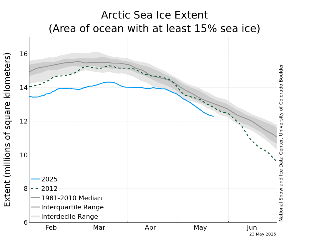
Chartic graph does not give daily data , it give an average of some sort.
The data direct from the ftp site is given above.
Why deny the data. !
I’m not denying the data, I’m noting the difference between JAXA and the NSIDC data you quoted. The NSIDC website didn’t indicate that the plot I showed was Chartic or that it was an average which is a bit misleading. What link do you use for the NSIDC data?
NSIDC sez no. National Sea Ice Data Center. Peak will be hit in March but little chance that current record low will recover by March. I assume this is satellite data on ice extent.
Daily data, direct from the NSIDC ftp site, is given above.
NSIDC says yes. !
If you use their “Charctic” graph, it gives some sort of 5 day average (iirc)
Consistency was never a ‘climate science’ strong point. My personal favorite is ‘the science is settled’ BUT ‘we need more money to study it’. Put Australia’s BOM in a bit of a bind a while back.
Look,
If you want to examine the BOM treatment of temperatures in Australia, ask them for the data used in the charts (graphs) that illustrate annual documents like state of the climate. These numbers easily reveal the adjustments over the years, to data that goes international for global average guesses. It is possible that these numbers are on a BOM internal list of what is not to be released. One can digitise each annual pictorial graph, but that is a dull way to do research. Geoff S.
I know. Wrote specifically about the ‘scandal’ adjustments at the pristine Rutherglen Ag Research Station in essay ‘When Data Isn’t’ in ebook Blowing Smoke.
One of the things DOGE is bringing to light is how USA has been financing world wide efforts to train “journalists” to promote Marxist (my terminology) ideology, like AGW, and support news outlets to hire them. In other words, create propaganda, not news. People should be aware by now that ‘Global Warming’ has morphed into ‘Extreme Weather’ and the go-to for anything abnormal. Too much ice? Too little ice? Too hot? Too cold? Too much …. place your subject here? Too little …. place your subject here? None of it has anything to do with ‘science’. They are also trying to discredit science to further their ideology. And they came close.
DOGE is bringing a lot to light. Not just USAID—that was easy low hanging fruit.
Wasteful DEI, among other things leading to ATC understaffing at FAA. Antiquated IT systems that should long ago have been replaced. $1000 per ordinary paper cup. 15000 newly hired IRS employees having nothing to do with processing or auditing tax returns. NIH research grants with an average 29% ‘administrative overhead’ when the private MAX is 15% and the Gates Foundation is 10%. $59 million of FEMA money spent on illegal aliens in NYC. $20 billion shoveled out the EPA door to 8 green NGO’s. And DOGE hasn’t even started on the two big money pots at DoD and HHS.
$1000 per ordinary paper cup
You need to investigate this. What’s the rest of the story? {see Paul Harvey}
DOGE brought it to light. Musk mentioned it in the Oval Office meeting/pressed a few days ago.
I asked Will Happer to his face if he would take a job with Trump second term, he wasn’t sure. Let’s hope Trump asks and persuades him.
Eric, Happer is quite old and has fought his battles. It is for us ‘youngsters’ (I am 74) to carry on, And we will.
“It is for us ‘youngsters’ (I am 74)”
Just a baby !!!
They saved money because staples were $2000.
Do the DOGE math.
A supposed relative bargain for all the federal employee retirement paperwork being processed by hand at Iron Mountain.
Let’s do a quick DOGE analysis. Average Iron Mountain employee salary $60k (ok, made up). Per DOGE, 270 people process about 10k retirements / month. Based on my father’s military retirement papers, average is about 5 (enlistment, promotions, rank, age at retirement, DD 214 discharge), so ~4 staples.
So only 10000 forms /mo * 270 people* 4 staples per form= only 148 staples per person month = a bargain at only ~$0.5 per retirement staple.
Only problem is, at Staples staples only cost $0.0147 each in box blocks of 5000.
Decades ago, so I do not remember all of the details and specifics, but it does highlight how things go wrong. It was reportedly a true story from a credible source.
A soldier wanted to pound a nail in the wall of his barracks to hang a photo above his bed. He had the nail but lacked a hammer. No tools were kept in the barracks. He asked his sergeant what to do. The sergeant instead of sending him to supply told him about Sears Craftsman tools. If it breaks, it is replaced for free, no questions asked. A hammer was about $15.
So the soldier went to procurement and was told he needed a procurement spec. He got the model number from Sears and put it on a piece of paper which the sergeant signed. Procurement told the soldier the spec was inadequate and needed a dimensioned drawing. The soldier got a picture with non toleranced dimensions from Sears. With this addition he returned to procurement and was told it needed to be signed by quality.
He gave the document to quality who then added all of the tests and inspections required and put standard tolerance on all of the dimensions. One of the tests was the maximum deformation of the hammer head given a spec force impact.
The soldier took the document to procurement who placed the order.
The hammer came in 6 moths later with a price tag of $1500. The price from Sears was only the cost to produce, inspect, and test per the procurement document. No G&A, no overhead, no profit was built into the price.
The soldier took the $1500 hammer and drove the nail in with one blow. The hammer then sat around unused.
So yes. The $1000 paper cup needs verification and explanation (aka transparency);
So Biden wanted to convert all departments to paper straws instead of plastic ones because they were only $167.50 each compared to the $1,000 each paper cups?
🙂
Good one. I go to lunch occasionally now with Charles Rotter, who moved in just up the Galt Ocean Mile a few blocks. We go to lunch at his favorite adjacent resort Tiki Bar maybe once a month or two. My pet Tiki Bar peeve is their paper straws. I drink unsweetened iced tea, and the paper ones collapse before the first glass is finished, before we get to WUWT stuff.
Rud, I certainly hope you don’t keep doing this same thing again and again, and expecting a different outcome?
Because . . .
🙂
A hearsay .. in 1980s Indonesia sent many students to study abroad. They sent STEM students to Eastern Europe, and social science students to the US to become Marxists.
The great and powerful Wizard of COz is capable of all things! Heat waves, cold spells, floods, and droughts; when the mighty Wizard (also known as CO2) wishes it, it WILL happen!
It looks like the authoritarians who want to control the weather with our tax dollars are just like the ones who want to control our food and health care decisions! HmmmmmmMarxism, anyone!?
“The great and powerful Wizard of COz is capable of all things!”
Love it !!!
It is a case of the classic sucker bet of “Heads I win, tails you lose.”
Can’t vouch for the marine science physical papers, but my rule of thumb for biological is caution over papers with “tipping points, unprecedented, catastrophic, regime changes,” and others which don’t come immediately to mind. Can’t discount them, but too often they show lack of homework and, or caveats buried in the paper but not shown in the abstract. One example has been supposed unprecedented marine diseases but with some rational like this one. Human blame occurs but changes difficult to determine. They don’t leave many fossils, for example, and unexpected may just be due to lack of education. Lafferty, K. D., et al. 2004. Are diseases increasing in the ocean? Annual Review, Ecology, Evolution, Systematics. 35:31-54.
https://doi.org/10.1146/annurev.ecolsys.35.021103.105704
Ocean acidification is endangering marine life.
pH of 8.5 reduces to 8.3 and that is the risk? Acidic is less that pH 7.0.
Alarmism anyone?
It’s the full employment effect of the climate crusades.
According to Climatistas, climate change is all things to all people at all times, so long as it is bad.
Unlike the equatorial belt between the Tropic of Cancer and Tropic of Capricorn, the sun never gets directly above the polar oceans. The polar oceans tend to look dark to a casual observer because the water reflects specularly (like a mirror) and the reflectivity varies considerably (Between 2% and 100%.) with the angle of incidence. Above the polar circles is where the reflectivity changes the most for a degree of change in the angle of incidence, whereas the reflectivity is almost constant between the Tropics.
To observe the light being reflected off the water, one has to be looking towards the sun, and at an angle that matches the angle of solar incidence. To all other observers, with a clear sky, the water is going to look dark; however, that does not mean that all the incoming light is absorbed.
https://wattsupwiththat.com/2016/09/12/why-albedo-is-the-wrong-measure-of-reflectivity-for-modeling-climate/
According to Mr. Worrall, in announcing the latest doom and gloom about
anthropogenic global warming (catastrophic as it allegedly is), the government
authorities, through their obeisant BBC amanuenses, stated: “The world’s frozen
oceans, which help to keep the planet cool, currently have less ice than ever
previously recorded, satellite data shows. Sea ice around the north and south poles
acts like a giant mirror by reflecting much of the Sun’s energy back into space. But
as rising temperatures cause this bright layer to shrink, the dark ocean below can
absorb more heat, warming the planet further. Every year, every data point that we
get suggests that this isn’t a temporary shift, but something more permanent …”.
We can define the total polar sea ice of the earth, approximately, as the total
ice floating in the seas above the Arctic Circle and below the Antarctic Circle, with
some adjustments due to geographic features. Contrary to the above quote, this level
of sea ice positively does not contribute to the heating or cooling of the
earth as a whole. Rather the temperature of the earth as a whole is what affects
these areas to be either more or less frozen. In other words, the sea ice is the
thermometer, not the heater or the cooler.
One reason for this is that the polar regions of the earth only receive the sun’s
energy at high angles of incidence (if at all) and, the sun being the ONLY source of
the heating of the surface of the earth (outer space being the ONLY source of its
cooling), can only follow the temperatures of the earth below and above them which
receive overwhelmingly much more sunlight per unit area because of the lower angles of
incidence of the sun falling on those areas compared to those polar regions.
When you combine this reason with the fact that while ice is extremely reflective
of sunlight, when it melts (at sea level) the water (dark or not) thereby produced is
also highly reflective IF the sun hitting it is at a high enough angle of incidence,
which it will be for the polar regions, then whether it’s ice or water at that
latitude it just doesn’t make much of a difference in the little heat energy that can
be absorbed from the sun there adding to the heat content of the entire planet. And
so the ice cover extent of the polar regions, per se, simply cannot be blamed for
global warming or cooling. Of course, when you have enough sheet ice built up on the
land surfaces of the polar regions (especially of the Arctic), its weight can cause it
to flow further away from the poles (on any land surface nearby), which can result in
far more surface ice closer to the equator, leading to far more sunlight reflectivity,
leading to an extreme glacial period for, first, that one hemisphere of the earth, and
then, the entire planet, but that’s another story.
And as far as this sea ice decline being permanent is concerned (how can any
decline of anything be “permanent” — how does it go further down after it hits
zero?), one must also be aware that certain agings of arctic sea ice as inferred from
satellite data clearly suggest that this lowering of the extent of polar sea ice
coverage that has been observed for the last 50 years or so will shortly plateau out,
so even that might not be a continuing feature of the Arctic region — and, by
implication, the Antarctic — much longer. Not that it matters.
To further twist the knife, according to the global warming wackadoodles our
present “large” levels of CO2 in the atmosphere, in the colder regions of the earth,
can actually produce a net cooling effect counteracting the warming alleged to be
caused by the lessening of the floating ice there — they call it the anti-greenhouse
effect. To quote Alfred E. Neuman: What, me worry?
David Solan
The totality of polar sea ice is not facing the sun. Any effects of ice melting is a fraction of the total area when viewed head on. Spherical geometry plays a big role.
Angle of incidence. Yes. Reflection? Yes. The water appears dark due to optical depth and that very little light passing into the depths is reflected back to the surface.
In radar is is called skin depth. The calculations are the same for water, ice, granite, sand, etc. Each has a different permeability and permittivity. Funny of fields and waves (electro magnetics) never enter into the conversation.
What’s worse, increased ice actually causes warming by insulating the warmer sea below. Less ice promotes cooling by allowing the warmer sea to radiate and cool.
It’s a firm and obvious negative feedback. D’oh!
Angle of incidence is one reason the divide by 4 to obtain an “average” insolation over the surface is a joke.
It’s a scientific fact, not a joke!
The insolation is the amount of solar radiation reaching the top of the atmosphere, that can be calculated by muliplying the intensity of the solar radiation at the Earth’s orbit by 𝜋r^2 (sphere’s cross sectional area). Since the Earth rotates the average insolation is spread over 4𝜋r^2 (sphere’s surface area), in other words, divide by 4. To determine the insolation at the Earth’s surface it is necessary to allow for the loss as the radiation passes through the atmosphere starting from the value at the top of the atmosphere, thus dividing by 4 is a key part of the calculation.
All Global Warming roads lead to Climate Change.
Definition:
Climate – 30 year (IPCC) average of weather over a locale or region.
Climate change – difference between today’s weather and the 30 year average.
Both are statistical constructions and neither can force of cause anything.
The climate is changing second by second because the current weather replaces the 30 year old weather in the running average.
If the globe warms, climate changes, by definition.
“The Antarctic sea ice extent, though varying considerably with season and region, had been on a slight increasing trend from late 1970s until mid-2010s when the trend was suddenly reversed. The sea surface temperature anomalies related to the multi-decadal expansion and recent contraction in the Antarctic sea ice extent remain to be uncovered. Here, we demonstrate that the variations in the Antarctic sea ice extent from 1979 through 2020, including the abrupt change in direction that occurred in mid-2010’s, can be explained at least partially by the sea surface temperature (SST) oscillations in the Pacific and Atlantic Oceans. Specifically, we show that the changes in the Antarctic sea ice extent are significantly correlated with the Interdecadal Pacific Oscillation (IPO) in all seasons and to the Atlantic Multidecadal Oscillation (AMO) in austral winter and spring.”
Why don’t they just admit the obvious. With a process that has been undergoing constant change for millions of years, trying to pin down a “cause” over a few decades is an absurd chase.
https://link.springer.com/article/10.1007/s00704-023-04820-7
Would be better if most of the water trapped as ice melted and went back into the biosphere – our current planet is a cold, dry, desert compared to it heyday in the Cretaceous or Jurassic periods.
The world’s frozen oceans, which help to keep the planet cool, currently have less ice than ever previously recorded, satellite data shows.
So we are only discussing the satellite era – from the late 1970’s.
Arctic sea ice developed about 3 million years ago, so the satellite era represents measurements for 0.000015% of its existence.
Antarctic ice sheets developed about 35 million years ago, so the satellite era represents measurements for 0.0000013% of its existence.
Another example of biased and/or misleading reporting. Its a bit like looking at your bald grandfather and concluding he was bald throughout his life.
Or looking at your pregnant wife and concluding she was pregnant at birth.
There are all kinds of things that affect Arctic and Antarctic ice. I doubt seriously that me driving my Avalanche is one of them. We need o force these CAGW clowns to show us the science proving CO2 can raise average global temperatures catastrophically. So far no one has, let’s see who will be first.
I had read that there were active volcanoes under the Antarctic ice sheet. Strange that that would have no effect on ice melting.
Physics has changed a lot since I was at university.
I think I read somewhere that there was heightened seismic activity in the Antarctic at the moment.. maybe leading to one of the land volcanoes erupting…
Time will tell… but we know human CO2/climate-change will be blamed.
in the meantime the upper midwest is about to get a weeklong bitter cold spell. this with great lake’s ice coverage hovering just below average.
odds this week doesn’t make a dent at all? plan on it.
bas_ice_compare.png (1500×850)
Antarctic sea ice at record high levels this Winter.
During the winter it was the second lowest maximum on the record:
https://forum.arctic-sea-ice.net/index.php?action=dlattach;attach=420522;image
Key words: on record.
Sorry, people, I made a big mistake with the last blurb I posted yesterday. I
forgot a significant point.
Right about now, in February of 2025 (actually a few weeks ago), the earth is at
perihelion. Also, it hit the height of summer in its southern latitudes last December
of 2024. This basic alignment won’t recur for another 21,000 years. It means, if you
just consider Milankovitch cycles, southern climes right now are at their warmest in
21,000 years. And wouldn’t you know, the global warming wackadoodles are wetting
their panties about the record LOW amount of floating ice there is in Antarctica right
now. Hello. Warming melts ice. Nothing to do with CO2. Is anyone there?
Now, in 6 months, around August of 2025, considering only Milankovitch cycles, the
earth will be about at aphelion and the Southern Hemisphere will be at the height of
its winter season. Also, because aphelion is hit when the earth is at its slowest
radial motion around the sun, the southern hemisphere winter then will last longer than the
southern hemisphere summer is doing right now. Again, if you just consider Milankovitch cycles,
the southern climes will be at a record cold then, that won’t be seen for another
21,000 years. Which one of you brave global warming “skeptics”, who doesn’t believe
the earth is warming, and therefore who doesn’t believe in Milankovitch cycles either,
will bet me, right now, that Antarctica’s floating ice will not be at near record HIGHS
this coming August? You better believe it will.
David Solan
To abuse Bill Clinton, “It’s the sun, stupid.”
The IPCC says, in its AR6 WG-I report, section 1.4.1, “Baselines, reference periods and anomalies”, on page 192 :
The satellite record now includes 46 full years, 1979 to 2024, which can be divided into two 23-year long “halves” (1979 to 2001, midpoint 1990 + 2002 to 2024, midpoint 2013).
23 is greater than 20 … which according to the IPCC is enough to calculate the “climate” for each half, and then see how much “climate change” has occurred !
.
Comment by “antigtiff” (timestamped “February 16, 2025 10:28 am”) earlier in this comments section :
The attached graph shows the averages for the two halves of the satellite sea-ice record, plus the “record minima” and 2025 values, from NSIDC daily data updated to 16/2/2025.
NB : My initial colour scheme included “Antarctic = shades of green”, but after thinking I had selected the wrong column somewhere (yet again) I changed one line to red to visibly show that the two “Antarctic daily average” curves are separate lines.
Using the IPCC-compatible definition of “climate = 20+ years of weather data”, the “climate” in the Antarctic has not changed over the last 46 years.
The change in global (Arctic + Antarctic sea-ice) “climate” was entirely due to a drop in the Arctic sea-ice numbers.
The new “lowest global sea-ice sum record” numbers come from a combination of Arctic (near annual maximum) sea-ice numbers oscillating around the “daily minima” line and a “plunge” in Antarctic (near annual minimum) values from “normal” levels at the start of the year.
It is unclear how much, if any (?), of this was due to (summer) storms and winds around Antarctica breaking up the sea-ice and/or pushing it north into the “melt zone”.
.
The same basic question applies here, as is so often the case with hysterical media headlines :
What is the difference between “weather” and “climate” ?
PS : “If you would debate me, first define your terms” — Voltaire
NOAA and NSIDC have become politically oriented climate activist organizations, leaving science in the trash. Their weaponization of science to promote political ideology destroys credibility; they’ve sealed their fate…..