Reposted from the Cliff Mass Weather Blog
If you are living west of the Cascade crest of Oregon and Washington, tomorrow will be a day you will never forget.
The latest model runs, all at very high resolution, show even more profound extremes than previously predicted. And the end of the event will be extraordinary, with temperatures falling by as much as 50F within a few hours.

Records Already Broken
Many records fell yesterday, including a new all-time high temperature at Portland (108F) and daily or monthly records falling at dozens of stations. But his is nothing compared to what will happen now.
Situation Right Now (Noon Sunday)
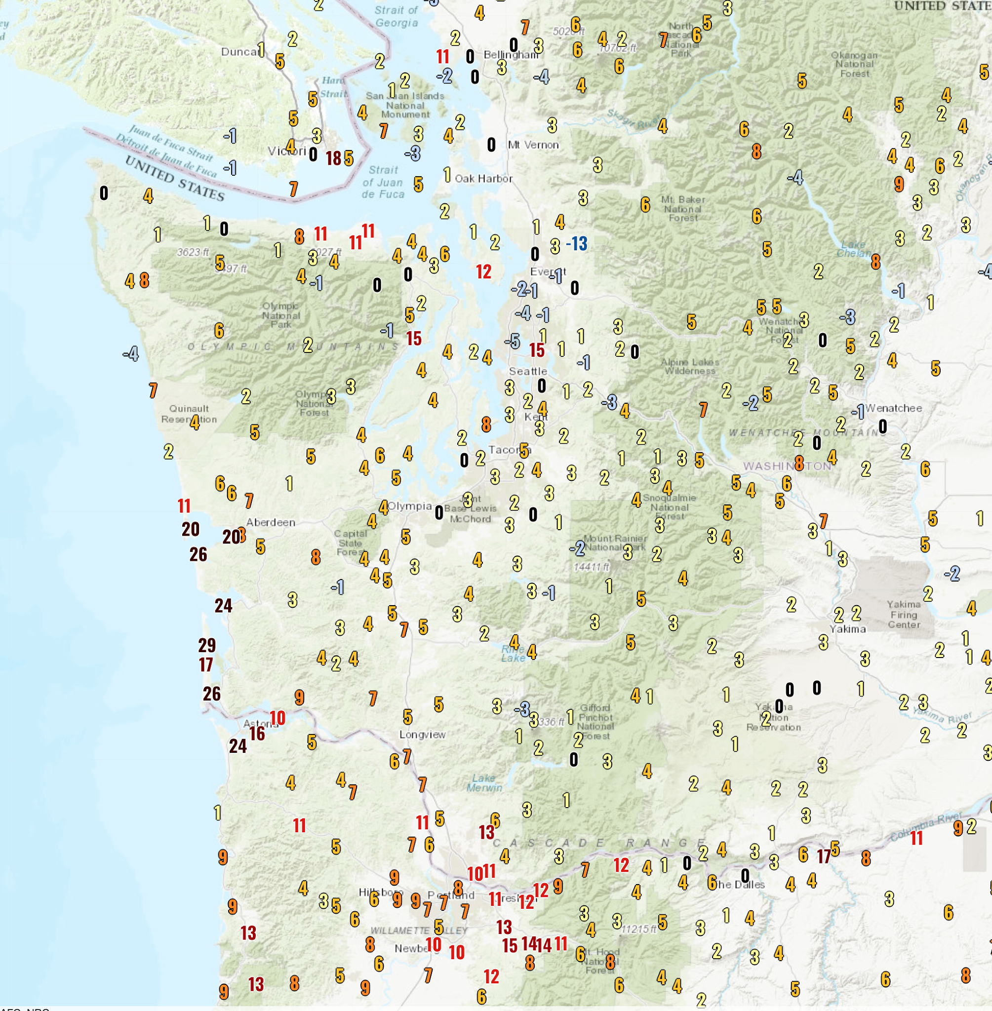
A fascinating plot (below, click on image to expand) shows you the 24-h temperature change–how we stack up temperature-wise compared to exactly one day ago.
Along the SW WA coast, some locations are 15-30F warmer, because of the switch to easterly (from east) winds–pushing away the cool, ocean air. But look at the Portland area…many locations are 10-15F warmer because of increased offshore flow, with the air warming by compression as it sinks over the western slopes of the Cascades.

The new 108F record at Portland is going to be OBLITERATED today. 115F is quite possible.
But north of Seattle temperatures were a bit cooler.
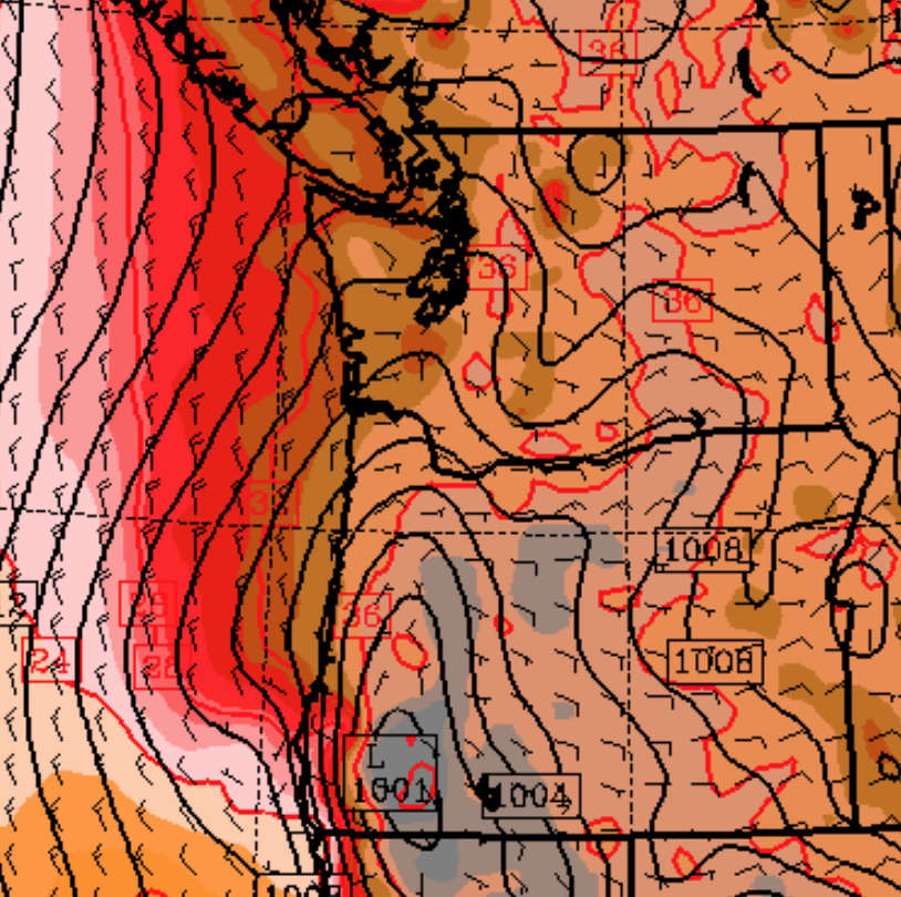
Ironically, it is connected with the warmth along the coast and around Portland! To explain, here is the forecast sea-level pressure map at 5 PM today. You can see the low-level winds and lines of constant pressure (isobars). You will also notice an area of low pressure–the thermal trough--centered in the Willamette Valley. It is the result of warm air produced by easterly flow descending the western Cascade slopes. With low pressure to the south and high pressure to the north, the thermal trough produced northerly winds over the Puget Sound, with the air cooled as it moved over cooler water to the north.

But that low pressure is going to move northward overnight and Puget Sound will be “enjoy” the torrid conditions now burning Portland.
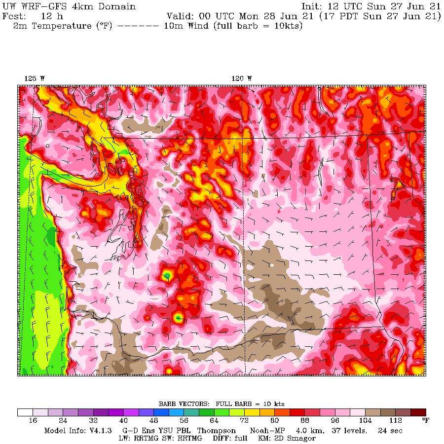
Here is the latest temperature forecast for 5 PM today. You can see the very warm conditions around Portland (dark brown is 109-112) and you will see very warm conditions along the lower western slopes of the central Washington Cascades and nearby lowlands. Near the water around Seattle near the water, it will ONLY be the upper 90s.

Tomorrow: The Day of Unimaginable Extremes
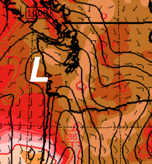
But tomorrow, it all goes horribly wrong. The thermal trough moves northward and westward, pushing the strong easterly, downslope flow northward to over the central Cascades (see map for 11 AM Monday). The sinking air will compress/warm as it sinks.

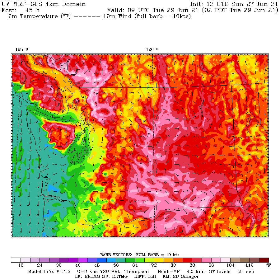
The burst of downslope, compressional heating will cause temperatures to warm beyond the experience of any living inhabitant of the region (see forecast temperatures at 5 PM Monday). Temperatures will rise above 112F on the eastside of Puget Sound and above 100F for everyone more than a few miles from the water. Portland will be similarly warm. And so will the lower elevations of the Columbia Basin. Heat apocalypse. What more can be said?

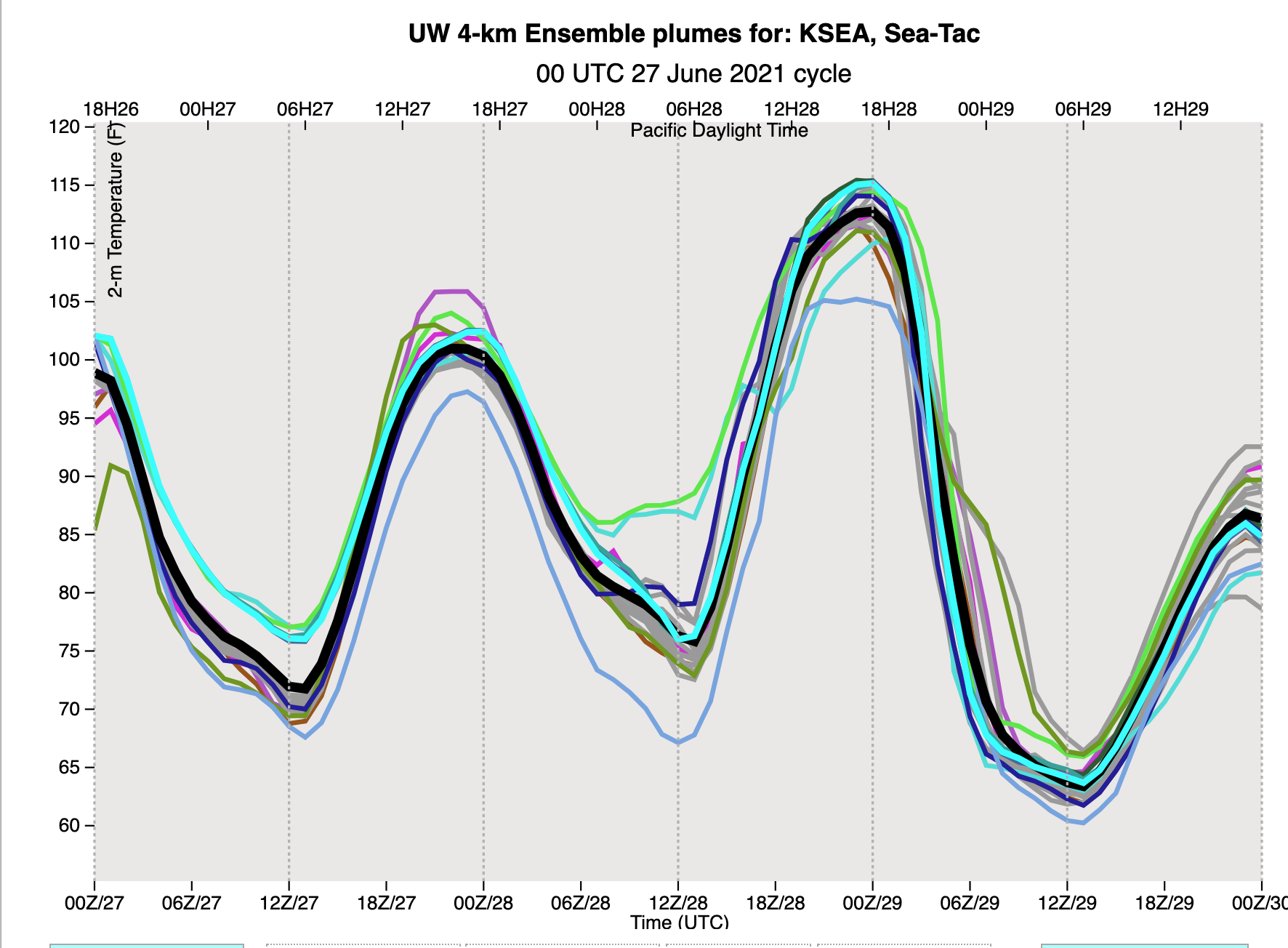
You all know that looking at one forecast is not good enough. We need to examine many (ensembles) to evaluate our confidence in the forecast. Well, here are the high-resolution ensemble temperature forecasts at SeaTac airport. Time is on the x-axis (00Z29 is 5 PM Monday). Nearly every model run is taking SeaTac to around 112F.

And there is more…..after the temperature peaks around 5 PM it plummets steeply, like an insane meteorological roller coaster. Some of you will be sweating in 110F temperates around dinner time, but looking for a light sweater around 6 AM.
The reasons for this profound shift? The thermal trough will begin to move eastward over the Cascades, with an onshore marine push bringing in cool air off the Pacific (see forecast map at 2 AM Tuesday, green and blue colors indicate cool temperatures)

It will still get warm on Tuesday (80s for many), but the savage heat will be broken. Good luck tomorrow. You will be talking about it for a long time.
This is the “perfect storm” producing extreme temperatures for our region. If you want to see how I feel, check out the video (go 60 seconds in) [I cued it up for the WUWT audience~cr]
Temperatures in North America during the upcoming winter could also be extreme.
http://www.bom.gov.au/climate/enso/wrap-up/archive/20210622.sstOutlooks_nino34.png
Haven’t I read that summers swelter and winters are bone-chilling during Little Ice Ages?
Try checking the extremes during Big Ice Ages.
I did a bit of research (at your suggestion) and found this article: At Peak Of Last Ice Age, Summer Temps Were 3-4C Warmer | Climate Change Dispatch
Ren, good to hear from you! I’d been wondering why I hadn’t seen any of your posts.
I have been watching the output from the BOM covering our neck of the woods (PAC NW) and it is garbage. The temperature plot looks like the teeth of a saw with temps going up and down 10 deg F every three hours. It’s no wonder so many of Aussies badmouth the BOM.
Portland’s burning?
112
That was last year. 🙂
If anybody sees a US media report mentioning the huge expansion and filling in of urban areas since previous records decades ago – please post examples. Imagine the increase in area of tarmac and volume of concrete over the decades. All adding to the long proven UHI effect.
True, but at least in Portland International’s case, there has been a DECREASE in nearby tarmac/concrete. An unused runway was removed several years ago and replaced with grass.
http://www.keex.net/current-projects/portland-runway-expansion#:~:text=Our%20new%20%2421%20million%20runway,air%20traffic%20mobility%20and%20efficiency.
Richard, dunno how you missed the PDX expansion project.
Curiously there’s been no BBC orgasm about this, but I’ll bet Mikey Mann is salivating
https://www.bbc.co.uk/news/world-us-canada-57634700
And this is exactly as climate science predicts… and it will happen again in the near future.
Ask yourselves, why should this extreme heat only happen right now if it is just weather?
and don’t forget this isn’t the only current N hemisphere heatwave setting records.
Please. “Climate Science” uses failed models to confabulate things. They love the “extreme weather” meme, because that way they are never wrong (according to them). Plus, it allows them to conveniently sidestep the issue of actual warming overall, which, unfortunately for them has stalled in recent years. Why now? Because it is indeed, just weather, which is always happening “now”.
Climate “science” ( where ever that lives ) predicts everything at the same time , that way they have all bases covered.
That allows unthinging goons like you to pop up and arbitrary claim it is “exactly” what was predicted without showing what was predicted and where so we can validate the “exactness” of your claims.
“don’t forget this isn’t the only current N hemisphere heatwave setting records.”
Don’t forget that just a week or two ago record cool temperatures were set all over the east coast of North America.
Global warming is predicted there is no caveat that its seasonal, yet here we are in high summer and it gets hot ,hotter than normal for a few days in a area ,thats called a heatwave. so what do we learn from this, it gets hot in summer, its not global its effecting one part of one continent, to be global warming it would need to see a similar temperature rise relative to the mean over a year then × how ever many years, so the word global in (global warming) is misleading used by msm to convince people like you its global warming.
Come back after you can show the above has been fulfilled and you might be taken seriously.
Meanwhile on my part of the planet its cool mid teens cloudy,with spots of rain the spring and summer combined have given about 5 days of what I would call warmth with sunshine.
The above is certainly out of place for summer and no sign of improvement, more note worthy than a continent that gets hot in summer and has a heatwave. Get real griff and think for yourself.
Been cold and rainy all week here, did the models predict this?
So, griff, what temperature SHOULD it be?
Having lived on the coast in two places on almost opposite sides of the world I have observed how it can be really cold in the middle of the day and considerably warmer or even hot in the middle of the night. This has nothing to do with climate change – it is simply certain recurring weather events. Because very few people keep a meticulous record of such events our memories are not a reliable record.
looks/sounds like Aussie weather
blistering heat sometimes fires with savage duststorms then massive temp drops and often torrential rains
its weather and it too will pass;-)
And? So what?
5am Monday PDX 76F and falling
https://w1.weather.gov/obhistory/KPDX.html
Modellers are going to be disappointed if they think it will 80F by sunrise around 6am.
https://www.google.com/search?client=firefox-b-d&q=temperature+portland
Roll on for another day of hyped up “all time” record weather predictions which don’t pan out.
I guess you need to eat crow. Until this morning the all-time record mildest low temperature was 74F. At the airport this morning it was 75F. The NWS forecast (which is NOT that stupid picture you linked to.) was for lows about 75F (70F in outlying areas and 80F downtown).
Just a quick note from the “Cascade Foothills” (Mill City, Oregon)…
Yesterday’s high at my location was 112F (111.7F, at around 5:00 PM, local time, as recorded by my PWS). You can see a link to the site here or at Weather Underground, here.
Note that there is a glitch with the WU display, as when it updates, the current conditions panel reverts to data that is now several hours old. The graphical timeline display does show as current, and also the WunderMap display.
Today’s high is supposed to be slightly less warm (ONLY 109F !!!!!)
I just hope that the thermal trough shifts a bit earlier than forecast and we can begin to see the return of our usual canyon breeze before late afternoon.
An update here… Per my PWS, we just hit 114.5F a bit ago. No sign of any relief just yet, and I have 60-year-old fir trees in my yard turning brown as I watch.
Intermittent power outages don’t help either.
And a final update for today… we hit, per the PWS (and it is a good one) 115.5F, then our “Canyon Breeze” kicked in and the temperature is dropping fast along with the cooling westerly winds. Dropped 10F in about 30 minutes.
Highest temperature ever recorded in Canada yesterday at Lytton B.C. of 46.6C (116F). Previous high was set in SK in 1937 at 45. Our town in MB was second highest set in 1936 at 44.4. Today and tomorrow forecast for Lytton is 47 (117F).
U need to take those highest ever temps with a grain of salt as environment canada has begun to delete or ignore lots of historical data claiming it doesn’t meet accuracy guidelines.
I think the real reason is to eliminate 1930s and earlier hot data.
Eugene Airport reading is 4 degrees less today than yesterday at the same time (9:54 a.m.).
We’s gonna need a lot of heat to catch up and pass yesterday.
There was no air movement yesterday morning, and the rest of the day it was all southerly. Now 7 to 10 mph northerly and likely to stagnate/shift around noon.
Appears that the event (here) is ending sooner than anticipated … yesterday high of 111 will be the peak for this one.
The only useful record temperatures are those accompanied by the instrument installation date.
Models simulating future weather for a few days out… Now this I will accept. Not enough time for small errors in data input to generate meaningless output plus some good computer age experience to have tuned the models even further. I have been noting how poorly my area forecasts at 10 days out have been…seems to be stretching their models capabilities – but at 3 and even 5 days out they are doing fair.
You can have all that heat, and here take some from Texas – we don’t want it. Send us more of your rain.
I wonder if people in Portland even know what an air-conditioner is? If they do, watch out for power grid situations.
Signed, Survivor of Freezagedon.
Does anyone actually believe these temp readings? NWS can scream all they want that such and such high was reached. Are they telling the truth? Reality has dictated they are NOT.
So you are saying there are thousands of people with their own Personal Weather Stations, including yours truly, conspiring with the NWS and the news stations to fake temperature readings all on the same weekend to ‘create’ an all-time weather event? Get off this board Troll!!
Brrrrrrr! Need a jacket.
“This Afternoon
Widespread fog. Otherwise, mostly sunny, with a high near 86. Southwest wind around 10 mph.”
I need to start closing the windows to keep my motorhome warm. 4 pm temp by internet and my weather station is 67 degrees F. Not 86.
I do not have a problem with weather warning not coming to pass it is better to be prepared.
At my present location my motorhome is situated to catch the afternoon for warming. On the east side of the state, it is parked so that an awning provides shade.
In other words, to be safe all I need is shade and water to drink.
To be comfortable, I need a jacket and air conditioning. Yesterday, sat outside in the shade. I did not need a blanket to sleep.
Since the prediction for today was to be warmer, my plan was to start my bid ass generator and run the A/C. Never got above 80.
Based on my experience. This is normal PNW, a mild climate with some days hotter than others. It is exactly what I expect. Maybe because I get outside once in a while.
It’s even worse than we thought, see the sciencey Diagrams with lots of red; that’ll convince ’em.
I’ve been battling a multi-billion dollar attempt to enslave me for over 25 years now, and I am still holding up. Pretty good I’d say. And so should say all of us who have not swallowed the well funded Blarney Science fraud.
Meanwhile, we are having a big heat wave in the northeast, with some record-breaking temps. Big whoop. 110 years ago, in July, there was a monstrous heat wave lasting close to two weeks with little relief, and thousands died as a result. They had no way of dealing with it. Today, thanks to fossil fuels, we do.
Here is the NWS table for Oregon and Washington, as at 5pm 28 June

The heat wave ended up yet again tying OR and WA records, while beating BC and Canadian record by one degree F. Big whoop.
Is there going to be a followup article on actual temps to predicted temps?
Cliff Mass has a new post here on that. His previous posts on this event have appeared here.
Second coldest month of the last 2 years according to Nick Stokes Temple mesh data set ( 3 days to go to see if it could be the coolest month in the last 24 months.
Would help if he used a real zero baseline for his graph, it is not that he does not have the technical ability to do so.
–
What this means is this little bit of a very localised heat outbreak (world context) due to natural variation is actually a true anomaly in the context of the current world temp.
Highlighting it is fantastic for those locals who like to see records set either way.
Claiming it means anything other than natural variation in a cooler year is another matter entirely.
Hot on the heels of a story about how we’re all being subjected to misinformation, One News in NZ have just told us that this weather event has been attributed to climate change.
So who to believe? Somebody who goes to the trouble of explaining how this occurred, or our publically funded propaganda outlet, who wouldn’t dream of misleading us?