By University of California Davis May 6, 2020
The lightness of water vapor buffers climate warming in the tropics.
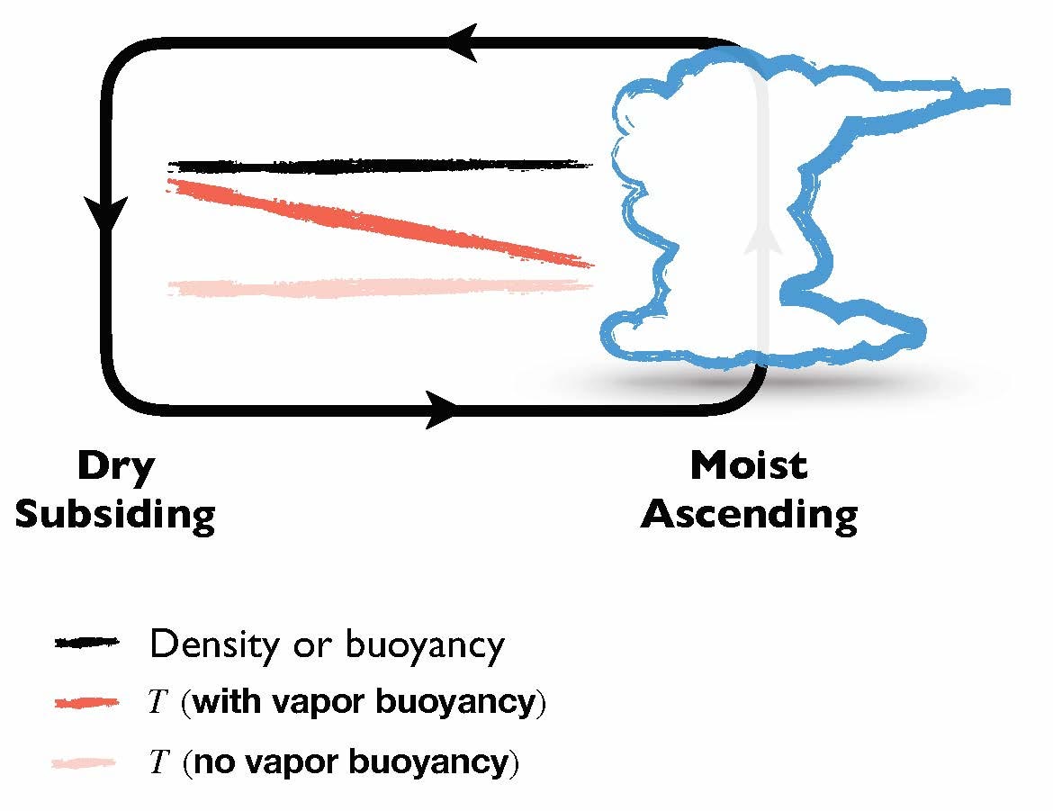
Conventional knowledge has it that warm air rises while cold air sinks. But a study from the University of California, Davis, found that in the tropical atmosphere, cold air rises due to an overlooked effect — the lightness of water vapor. This effect helps to stabilize tropical climates and buffer some of the impacts of a warming climate.
The study, published today (May 6, 2020) in the journal Science Advances, is among the first to show the profound implications water vapor buoyancy has on Earth’s climate and energy balance.
The study found that the lightness of water vapor increases Earth’s thermal emission by about 1-3 watts per square meter over the tropics. That value compares with the amount of energy captured by doubling carbon dioxide in the atmosphere.
“It’s well-known that water vapor is an important greenhouse gas that warms the planet,” said senior author Da Yang, an assistant professor of atmospheric sciences at UC Davis and a joint faculty scientist with Lawrence Berkeley National Laboratory. “But on the other hand, water vapor has a buoyancy effect which helps release the heat of the atmosphere to space and reduce the degree of warming. Without this lightness of water vapor, the climate warming would be even worse.”
Humid air is lighter than dry air under the same temperature and pressure conditions. This is called the vapor buoyancy effect. This study discovered this effect allows cold, humid air to rise, forming clouds and thunderstorms in Earth’s tropics. Meanwhile, warm, dry air sinks in clear skies. Earth’s atmosphere then emits more energy to space than it otherwise would without vapor buoyancy.
Here is the abstract from the paper which can be found here.
Abstract
Moist air is lighter than dry air at the same temperature, pressure, and volume because the molecular weight of water is less than that of dry air. We call this the vapor buoyancy effect. Although this effect is well documented, its impact on Earth’s climate has been overlooked. Here, we show that the lightness of water vapor helps to stabilize tropical climate by increasing the outgoing longwave radiation (OLR). In the tropical atmosphere, buoyancy is horizontally uniform. Then, the vapor buoyancy in the moist regions must be balanced by warmer temperatures in the dry regions of the tropical atmosphere. These higher temperatures increase tropical OLR. This radiative effect increases with warming, leading to a negative climate feedback. At a near present-day surface temperature, vapor buoyancy is responsible for a radiative effect of 1 W/m2 and a negative climate feedback of about 0.15 W/m2 per kelvin.
HT/Clyde Spencer
Some nonsense about humid air (clouds) from Scientific American:
https://de.quora.com/Why-do-clouds-float
https://www.scientificamerican.com/article/why-do-clouds-float-when/
Some Nonsense from Scientific American
https://www.scientificamerican.c…
Why do clouds float when they have tons of water in them?
Douglas Wesley, a senior meteorologist in the Cooperative Program for Operational Meteorology, Education and Training (COMET) at the University Corporation for Atmospheric Research, explains:
Image: RON HOLLE, University of Illinois Cloud Catalogue
FLOATING CLOUDS.The water and ice particles in the clouds we see are simply too small to feel the effects of gravity. As a result, clouds appear to float on air.
Clouds are composed primarily of small water droplets and, if it’s cold enough, ice crystals. The vast majority of clouds you see contain droplets and/or crystals that are too small to have any appreciable fall velocity. So the particles continue to float with the surrounding air. For an analogy closer to the ground, think of tiny dust particles that, when viewed against a shaft of sunlight, appear to float in the air.
Indeed, the distance from the center of a typical water droplet to its edge–its radius–ranges from a few microns (thousandths of a millimeter) to a few tens of microns (ice crystals are often a bit larger). And the speed with which any object falls is related to its mass and surface area–which is why a feather falls more slowly than a pebble of the same weight. For particles that are roughly spherical, mass is proportional to the radius cubed (r3); the downward-facing surface area of such a particle is proportional to the radius squared (r2). Thus, as a tiny water droplet grows, its mass becomes more important than its shape and the droplet falls faster. Even a large droplet having a radius of 100 microns has a fall velocity of only about 27 centimeters per second (cm/s). And because ice crystals have more irregular shapes, their fall velocities are relatively smaller.
Upward vertical motions, or updrafts, in the atmosphere also contribute to the floating appearance of clouds by offsetting the small fall velocities of their constituent particles. Clouds generally form, survive and grow in air that is moving upward. Rising air expands as the pressure on it decreases, and that expansion into thinner, high-altitude air causes cooling. Enough cooling eventually makes water vapor condense, which contributes to the survival and growth of the clouds. Stratiform clouds (those producing steady rain) typically form in an environment with widespread but weak upward motion (say, a few cm/s); convective clouds (those causing showers and thunderstorms) are associated with updrafts that exceed a few meters per second. In both cases, though, the atmospheric ascent is sufficient to negate the small fall velocities of cloud particles.
Another way to illustrate the relative lightness of clouds is to compare the total mass of a cloud to the mass of the air in which it resides. Consider a hypothetical but typical small cloud at an altitude of 10,000 feet, comprising one cubic kilometer and having a liquid water content of 1.0 gram per cubic meter. The total mass of the cloud particles is about 1 million kilograms, which is roughly equivalent to the weight of 500 automobiles. But the total mass of the air in that same cubic kilometer is about 1 billion kilograms–1,000 times heavier than the liquid!
So, even though typical clouds do contain a lot of water, this water is spread out for miles in the form of tiny water droplets or crystals, which are so small that the effect of gravity on them is negligible. Thus, from our vantage on the ground, clouds seem to float in the sky.
Answer originally posted May 31, 1999
My comment:
The nonsense:
1. For an analogy closer to the ground, think of tiny dust particles that, when viewed against a shaft of sunlight, appear to float in the air.
2. The water and ice particles in the clouds we see are simply too small to feel the effects of gravity.
3. The total mass of the cloud particles is about 1 million kilograms, which is roughly equivalent to the weight of 500 automobiles. But the total mass of the air in that same cubic kilometer is about 1 billion kilograms–1,000 times heavier than the liquid!
Ad 1.:
Dust particles in a house are moved by very small currents created by even very small temperature differences.
Ad 2.:
Any mass “experiences” gravity! Even molecules settle. The concentration of higher weight molecules – e.g. CO2 – is higher at the ground.
Ad 3.:
This calculation is only silly! The weight of a cloud is a high as the adjacent volume of air at the same pressure and temperature. Clouds never stay constant. They vanish if no energy is added (velocity or temperature).
In addition:
Even though I am not an expert in “Relativity Theory”, I learned from Einstein that even photons are experiencing gravity (zero mass but energy – equivalence of mass and energy).
Obviously even well recognized meteorologists and the editorial board of Scientific American do not now the basic fact, that humid air has a lower density compared to dry air. https://www.vaisala.com/de/lp/hu…
The above copied article showed up first when asking Google: why do clouds float?
Example for humidity calculations
Relative humidity/% Temperature/°C Pressure/hPa Density/kg/m^3 Water/g/Nm^3
0 20 1013.3 1.2041 0
100 20 1013.3 1.1936 18.609
Above calculations from the author use a water content of only 1g/m^3.
The density difference is 0.8796%. This looks very small. But these humidity differences – besides temperature differences – are driving the weather.
A rising cloud has a lower density compared to adjacent air. A raining cloud is heavier and a momentarily stagnant cloud has the same density.
Clouds are never permanent!
The polarity (charge) of the H2O molecules in a droplet is inversely proportional to the interconnectedness of the molecules to each other in the droplet. (Note: this is currently not understood/accepted by conventional science. See links below for more details.) Consequently the H2O molecules in larger and rounder droplets have a lower polarity (on average) than do the H2O molecules in smaller, less round droplets. (This fact is extremely important for understanding the emergence of vortices on windshear boundaries, more on this below.)
The greater is the polarity of the H2O molecules within a droplet the more it is effected by residual electric charges in the atmosphere (the origins of these electric charges can be both or either terrestrial [Earth’s electric field] and/or extraterrestrial [the solar wind].
The correct particles size for application of Avogadro’s law to determine the density of a parcel of air is not 18 but 18 x X, with X being the average molecular count of the molecules within the droplets. Consequently moist air is ALWAYS more dense (and heavier) than drier air. (Note: Since interconnectedness varies with size and shape of nanodroplets, the actual average polarity of the molecules within a droplet will also vary with changes in shape of nanodroplets. The more elongated is a nanodroplet the greater the polarity within.)
There is zero gaseous H2O in earth’s atmosphere (it is far too cold). (It is a myth that the invisibility of moist air is evidence that the moisture therein is gaseous.) The reason heavier, more dense, H2O droplets stay suspended in the atmosphere is due to the residual electric charges, mentioned above, or because it is part of a flow that is trending upward. Nanodroplets that are smaller and/or elongated (as a result of spinning, see below) will be invisible.
To understand updrafts in storms and why they are not the result of buoyancy (convection) you must first understand that structure in the atmosphere is the means by which all flow (including updrafts) takes place. Structure emerges in vortices. And vortices emerge on windshear boundaries.
The reason vortices emerge on wind shear boundaries is because the spinning of nanodroplets on wind shear boundaries elongates these droplets, increasing their polarity, allowing them to form the plasma that comprises the sheath of vortices.
Basis of Structure in Earth’s Atmosphere:
https://anchor.fm/james-mcginn/episodes/Vagueness-of-Convection-Versus-New-Basis-for-Structure-in-Storms-edjtjn
James McGinn / Genius
So you are claiming that the phase diagram for water is wrong and you are a lot smarter than those who produced it. Prove it with physical evidence. What you say in blogs doesn’t cut it. The misuse of scientific words could be considered fraud and saying scientist don’t know the truth could be considered libol.
For those following this thread who want to know who to believe, google “James McGinn” and “Fred H. Haynie” and decide.
Fred:
So you are claiming that the phase diagram for water is wrong . . .
James:
No, ‘Fred. I’m claiming that the standard assumption that clear moist air contains gaseous H2O is pseudoscience. You and all of meteorology are claiming that we can ignore the H2O phase diagram and assume that the moisture in clear moist air is gaseous. I am saying the H2O phase diagram is correct. You are saying it is wrong.
Fred:
. . . and you are a lot smarter than those who produced it. Prove it with physical evidence. What you say in blogs doesn’t cut it. The misuse of scientific words could be considered fraud and saying scientist don’t know the truth could be considered libol.
For those following this thread who want to know who to believe, google “James McGinn” and “Fred H. Haynie” and decide.
James:
Fred, if you don’t want me to dismiss you as one of many pretentious bozos out there you are going to have to get more rigorous here.
Here is something that I think you would find interesting, given you aeronautical background:
The Real Reason Moist Air Reduces Aerodynamic Lift
https://www.thunderbolts.info/forum/phpBB3/viewtopic.php?f=10&t=16652
James McGinn / Genius
President, Solving Tornadoes
The water in clear moist air is a gas. The clear moist air is a mixture of gases with different molecure weights. The density of a gas is inverely proportional to the molecular weight (PV/nT=R). The molecure weight of dry air is about 28.8 while water vapor is 18. Any amount of water vapor will make the mixture lighter. The lighter mixture rises. As it rises the tempeature decreases because there are fewer molecular colisions. When the temperature reaches the dew point, the air is saturated and some of the water vapor condenses. Condensation is an exothermic process and some of that energy is transferred to air molecules, raising the air temperature and making it lighter. That speeds up the rate of rise. Thus, thunderstorms can have upward velocities that can exceed the terminal velocity of large hail stones. However, with all that condensation and freezing, there is still a small amount of gaseous H2O going out the tops of thunderclouds.
Fred: The water in clear moist air is a gas.
James: No, its liquid. Consult an H2O phase diagram for details.
Fred: The clear moist air is a mixture of gases with different molecular weights. The density of a gas is inversely proportional to the molecular weight (PV/nT=R). The molecular weight of dry air is about 28.8 while water vapor is 18.
James: The correct weight for water is 18 x X, with X being the average number of molecules of H2O in its nanodroplets.
Fred: Any amount of water vapor will make the mixture lighter.
James: Moist air is always heavier than drier air. Always!!!
Fred: The lighter mixture rises. As it rises the tempeature decreases because there are fewer molecular colisions. When the temperature reaches the dew point, the air is saturated and some of the water vapor condenses.
James: LOL. If this was true clouds would not be so cold. Clouds are cold because the heat capacity (the ability to absorb energy in its vicinity) of the droplets in the atmosphere actually increases as the droplets combine into larger droplets.
Fred: Condensation is an exothermic. That speeds up the rate of rise.
James: Fred, you are just spouting blatant pseudoscience. Heat is energy that is fully entropized, it cannot cause directed winds.
Fred: Thus, thunderstorms can have upward velocities that can exceed the terminal velocity of large hail stones.
James: Ludicrous, there is only a 1% difference possible even if we give in to the absurd notion that moist air contains gaseous H2O.
Watch this:
https://www.youtube.com/watch?v=LwSyalcoRAk
Fred: However, with all that condensation and freezing, there is still a small amount of gaseous H2O going out the tops of thunderclouds.
James: Blatant speculation.
Ask Any Meteorologist
https://anchor.fm/james-mcginn/episodes/Ask-Any-Meteorologist-ebuh5q
James McGinn / Genius
You are not proving what you right is true by keep repeating something or just saying what someone else writes is wrong.
“pretentious bozos”. “genius”, “president”, “theoretical physicist”. The readers of this thread are smart enough to figure out which is most applicable. As for me it appears that it is a waste of my time trying to “educate” you.
Fred:
You are not proving what you write is true by keep repeating something or just saying what someone else writes is wrong.
James:
You got nothing!!!
James McGinn / Genius
Solving Tornadoes / Woke Meteorology
https://anchor.fm/james-mcginn