From Cliff Mass Climate and Weather Blog
Monday, December 24, 2018
Sad News: No More BLOB
A lot of folks are interested in the BLOB, the colorfully named area of warm water that periodically appears over the northeast Pacific. And there is major BLOB news…. it is gone. Let me describe the sad news.

Starting the autumn, the BLOB was relatively weak. To illustrate, here is the sea surface temperature anomaly (difference from normal) for the end of October–as much as 2-3C warmer than normal! This was associated with an area of persistent high pressure over the northeast Pacific.

But compare that situation to two days ago. The BLOB is essentially gone, with an area of cooler than normal water developing. Only immediately along the coast is the water temperature slightly above normal.

What killed the BLOB? Persistent storminess over the northeast Pacific, something that is no surprise to the storm-battered residents of the Pacific Northwest.
Here is the proof: the anomaly of the mid-tropospheric (500 hPa) heights from normal for the last 30 days. Blue and purple indicate lower than normal heights, which is associated with more and deeper low-pressure centers, which in turn cause strong winds. A big area of lower heights (or equivalently pressure) was found over the NE Pacific.

HT/ John F. Hultquist
With The Blob gone, Arctic Ice Extents will start recovering at a faster pace on the Pacific side, and when the Atlantic/Arctic oceans enter their 30-year cool cycles, Arctic Ice Extents will recover even faster.
Global Warming advocates will soon have an extremely difficult time explaining falling global temps and growing Arctic Ice Extents.
Of course, because it is evident that low solar activity interferes with the ENSO cycle.
https://cosmicrays.oulu.fi/
According to Climate4You, the AMO may finally have begun its cooling phase.
The great snowstorm is developing in the northern states of the US.

Submarine volcanoes… Professor Wyss Yim: Geothermal Heat and Climate Variability https://youtu.be/uF4ItdXyHKo lähteestä @YouTube
Isn’t it sad that we sceptics are potentially celebrating what we don’t want, a cooler planet, just to prove a point.
How much money, time and intellectual effort has been wasted on AGW?
The second question is rhetorical.
The jet stream is pushing strongly over California to the south.
https://www.tropicaltidbits.com/sat/satlooper.php?region=atlpac-wide&product=wv-mid
Two lows connect over Nebraska – warm and frosty.

High Pressure over the armpit (off the west coast and below the Aleutians) makes a warm water blob. The Clockwise rotation steers arctic air over the continent and makes for cold continental temperatures. Low pressure over the armpit makes an antiblob. Counterclockwise rotation steers oceanic air ashore over the west coast, and together with the Hudson Bay Low, keeps the weather pattern zonal and the continent a few degrees warmer than normal. That is what we’re seeing now. FWIW
Temperature anomalies in Asia reach -16 degrees C.


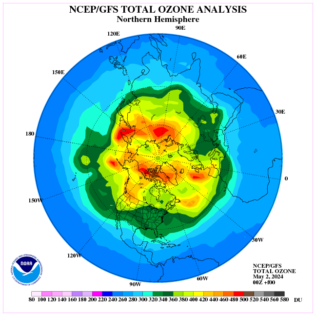
Why is it so cold in Asia? The answer is the circulation in the stratosphere (current polar vortex pattern).
The current circulation in the stratosphere causes that ozone accumulates over Asia and displaces water vapor from the top layers of the troposphere.
Here comes the Arctic ice.
I have 3 articles on the cause and effect of the Blob based on the analyses of observation records. They are –
(1) Explanation for the northern Pacific Blob. Imperial Engineer, Issue 25, 2016, p15
(2) Geothermal heat: an episodic heat source in oceans. Imperial Engineer, Issue 26, p14-15
(3) Geothermal heat and Arctic sea ice variability. Imperial Engineer, Issue 28, p26