Guest Post by Willis Eschenbach
Nerem and Fasullo have a new paper called OBSERVATIONS OF THE RATE AND ACCELERATION OF GLOBAL MEAN SEA LEVEL CHANGE, available here. In it, we find the following statement:
Both tide gauge sea level reconstructions and satellite altimetry show that the current rate of global mean sea level change is about 3 mm yr–1, and both show that this rate is accelerating.
So the claim is that tide gauges show acceleration. Let’s start with a look at the Church and White (hereinafter C&W) estimate of sea level from tide gauges around the world, which is the one used in the Nerem and Fasullo paper. The C&W paper is here.

Figure 1. Church and White sea level rise estimate.
Not real scary …
However, there is an oddity. Let’s take a closer look at the C&W sea level estimate shown in Figure 1.

Figure 2. As in Figure 1, but with a different scale.
Now, when I looked at that, the curious part to me was the change in the recent trend. For the last quarter century, we’ve had satellite sea level data, which began in 1993. In the past, the trend of the satellite data (1993 – 2013, 2.8 ± .16 mm/year, or about an eighth of an inch per year) has been almost double the overall trend of the tide gauges (1.6 ± 0.14 mm/year).
But in this most recent C&W estimate, the recent tide gauge trend is much larger. How much larger? Well … a lot. In fact, the recent C&W estimate is greater than the satellite estimate for the overlap period …

Figure 3. As in Figure 2, showing trends for the 21-year periods before and during the satellite era.
Why the increase in trend? Well, since 1993 they’ve mixed satellite data in with the tide gauge data.
To combine the tide gauge and satellite datasets, … Church and White (2011) and Ray and Douglas (2011) use empirical orthogonal functions of the satellite data with principal components derived from the tide gauge records. Church and White analyze changes in sea level over time, enabling them to use many tide gauges, some with short records, without needing to relate the absolute level of different tide gauges. SOURCE
But is this approach justified? I mean, did the tide gauge data itself go up during that time, so that it would be reasonable to use satellite data to refine the results?
Now, that is a tough question to answer, because the tide gauge data is sparse spatially and temporally, and it is also affected by vertical land motion. But you know me … I’m a data guy. So I went and got the full set of 1,512 tide gauge records from the Permanent Service For Mean Sea Level. In passing let me say that I don’t think they could make it harder to collect the data. It is in 1,512 separate files. Not only that, but the so-called catalog looks like this:

Figure 4. PSMSL Catalog. It is great fun to convert this to a simple computer file … but I digress.
To highlight some of the problems with converting tide-gauge data to global sea level data, here are ten typical records in the dataset:

Figure 5. Typical tide gauge records.
I’m sure you can see the difficulties. Some places the land is steadily rising from post-glacial rebound, and it’s rising so fast that the sea levels are actually sinking relative to the land. In other places, the land is sinking due to subsidence and groundwater extraction. Many records are short and have gaps. Generally, it’s a mess.
So … here was my thought about how to get around these issues: You’ll note in Figure 3 above that the increase in trend between the 21 years before the satellite era and the 21-year overlap during the satellite era was 2.1 ± 0.5 mm per year. And while the trends in the tide gauges are all over the place … I can look at the difference in the trends for each individual dataset over the same period. This gets rid of the problem of vertical land movement, which is constant over such a geologically short time period. So here was my procedure.
First, from the 1,512 tide gauge records in the PSMSL dataset, I selected all the records that contained 90% data over the 21 year period before the satellite era and also had 90% data over the succeeding 21 year period during the satellite era. This left me with 258 tide gauge datasets with coverage over the full 42-year period.
Next, I calculated the trend for each of these datasets for the period before and during the satellite era.
Then, for each tide station, I subtracted the pre-satellite trend from the satellite trend. And finally, I got the median and the uncertainty of those 258 trend differences. Figure 6 shows a graphic of those results.

Figure 6. Comparison between the values and the errors of the difference between the 21-year trend before the 1993 start of the satellite record, and the succeeding 21-year trend from 1993 to the end of the Church and White records. The C&W trends are shown in Figure 3 above.
Since the error bars (orange and red) do not overlap, we can say that the C&W estimate does NOT agree with the tide gauge data. And that, of course, means that it has been artificially increased by cross-pollution with satellite data.
Let me close by saying that I think that it is very bad scientific practice to splice together a terrestrial and a satellite record unless they agree well during the period of overlap. In this case, they disagree greatly over the period of record. For the detrended values over the period of overlap (1993-2013), the R^2 value is 0.01 and the P-value is 0.37 … in other words, there is absolutely no significant correlation between the satellite data and the C&W estimate.
And this makes it very likely that Church and White are manufacturing sea level acceleration where none exists … bad scientists, no cookies.
Finally, at the end of my research into this, I find that I’m not the only one to notice the discrepancy …

Figure 7. Different results for the satellite era depending on whether or not the satellite data is illegitimately spliced into the tide gauge records. SOURCE
My best to everyone. Here I’m staying indoors on a rainy Sunday, watching American football and researching the vagaries of sea level …
w.
As Always: I politely request that when you comment, you quote the exact words you are discussing, to avoid misunderstandings.
Data: So that others won’t have the hassles I had extracting and collating the data, I’ve put the full PSMSL dataset as a single comma-separated values (CSV) file here, and the PSMSL catalog here.
Data 2 :Commenter Bear was unable to download the files and suggested I change the end of the link. New links to PSMSL file here, and the PSMSL catalog here.
The point of it all is “climate action” that assumes that the rate of sea level rise is responsive to the rate of emissions and that therefore the rate of sea level rise can be attenuated by cutting emissions.
https://tambonthongchai.com/2018/12/05/attenuate-slr/
Also relevant
https://tambonthongchai.com/2018/12/14/climateaction/
The above article don’t support this — emission versus sea level rise. Figure 5 shows that some stations show Sea level rise and some other show the fall. Also, the data network at 1880 is different from 2013. The accuracy is affected by several factors like subsidense in land due to extraction of oil, gas, water; destruction of coastal zones against the law to meet the real estate and other ventures; sand removal, etc. etc. So, like in global warming, the word global is misnomer. So also the case with sea level rise/fall. Global averages have no meaning except fill the pages of literature. The more important issue is take the tide gauge of a location and look in to the aspects relating change in sea level. This is more useful for taking appropriate actions relating cyclonic systems impact on people living along it.
Also fitting the curve bit by bit has no meaning in such circumstances.
Dr. S. Jeevananda Reddy
I would like someone to tell me just how much sea level is affected by undersea volcanic action and other changes regarding land mass and erosions.
… and outer space detritus accumulated over the eons adds up too.
Very useful Willis. Thank you for your lucid explanation.
Thanks, Sage.
w.
I agree with nw sage!
Ditto…thank you Willis.
Very interesting and well done, as always.
Well it’s obvious to even the casual observer that we should be using tree rings.
/sarc (as if read)
That is getting a bit obvious as to manufacturing results if the two methods do not overlap.
“It is in 1,512 separate files. Not only that, but the so-called catalog looks like this:”
man what an ugly way of doing things
??? Care to unpack that? Willis E. seems to have done a reasonable and tedious job, and found Yet Another unjustified Alarmist claim.
I read Steven’s comment as attaching to the clumsiness of the catalog, not about Willis’ efforts.
DJ,
Ditto.
Play flagged, five yard penalty.
Perfectly reasonable and appropriate comment by Mosher there.
Yup.
Sounds like a job for a database using BLOBS. (Binary Large Objects)
Then you could cook it down to one backbone DBF with 1512 records with pointers to the individual data sets. Access would be greatly enhanced and simplified. Too bad DBF tech never made it big in the scientific community.
H/T to Willis for untangling the mess and putting up the results for us.
I agree. It’s the same in most commercial and government organisations. As one who cut his teeth on databases, I have found this very difficult to deal with.
The underlying problem is that databases require some knowledge of a language to extract, insert and edit data, unlike a spreadsheet where the data is immediately obvious and accessible. The problem with the spreadsheet is that people add non-standard data (which you can’t do in a database without changing the structure), and you need very deep knowledge to extract specific data.
The simple fact is that databases require a language to extract data, and a language or programming to insert data, and specific skills to create the structures. That stops people using them except for large amounts of data that need structure and security.
Unfortunately, during my career as a programmer, my experience of spreadsheets caused me to break out in a cold sweat every time I was asked to turn them into databases. I ended up doubling my estimates, then quadrupling them. I still found many instances where I’d underestimated the work.
Me too, and MS Access when used in the ph” I’ve developed this Access database and we want to make it company wide”
The worst data untangling I had to tackle involved the billing data from a third party for several hundred customers each with several hundred seperate telephone lines. The file contained individual cal and data records amongst other records. The file was a single monthly output of several million lines of comma seperated fields there were about 40 different record types each with a different number of fields. There was, so they said, no documentation because no one had ever wanted to load the data into a database. After several months effort and pouring over printed output sa couple of feet high for each month I got the data into an SQL server database. The effort was worth it as the billing experts then identified errors which meant repayment of hundreds of thousands of £. Once we’d sorted it suddenly the documentation became available.
The point of this story is that it is my belief that if someone makes it difficult to get the information there is probably a good reason, even if they have spent 25 years collecting it.
Well done Willis, bien joué as they say here
I have programmed in Access (and Dataease before it), Excel (Visicalc before it) and VBA for 20 years and BASIC for 30+ years.
I still help on 2 Free Forums as I retired 15 years ago.
So I know just what you guys are talking about, one of the big problems is guys creating their filing system and not accepting the need to move in to the 21 century for others to share their data.
A certain East Anglia Climate Scientist’s inabilty to effectively use Excel is legendery
Do not assume malice where incompetence is an explanation.
More often, though, ignorance of how things do NOT scale up. I learned a long time ago that when I did a quick favor for someone, to not let them take the spreadsheet or whatever. It always came back a month or so later with them asking why it was so slow now. Well, about two or three orders of magnitude more data that they’re trying to shove through it…
Thanks Willis, for all your hard work1
Steven Mosher December 17, 2018 at 6:22 pm
Absolutely ugly, Mosh. I truly don’t understand why people don’t do what I did and put their data in a flat file. Columns are categories, rows are instances or years—how tough can it be?
w.
yup
https://cran.r-project.org/web/packages/tidyr/vignettes/tidy-data.html
try
https://www.tidyverse.org/
https://www.tidyverse.org/packages/
http://varianceexplained.org/r/broom-intro/
Thanks, Steve, Hadley is indeed a genius.
w.
Thanks Steve!
agreed, it should be renamed the pmsl file.
Well …. if Mannie could do it , why can’t they ?
There doesn’t seem to be any penalties for this sort of ” stuff ” …. yet .
Also depends on which satellite data they are using. The data from U. Colorado are not actually measurements of sea level! They are the output of a model that combines measured sea level with a guess of how much the sea floor is being pushed down due to the increase of sea levels since the end of the last glacial (basically the opposite of glacial rebound). So the U Colorado data are really guesses about ocean VOLUME, not surface level though they attempt to portray it as such. It used to show sea level until a few years back when it stopped rising, so they had to make another “adjustment” (“glacial isostatic adjustment or GIA, they call it).
http://sealevel.colorado.edu/faq#n3113
“They are the output of a model that combines measured sea level with a guess of how much the sea floor is being pushed down due to the increase of sea levels since the end of the last glacial (basically the opposite of glacial rebound).”
According to science groupies (e.g., card-carrying “Skeptics,” science is self-correcting, so this is fake news, because it can’t happen.
BTW, suppose the ocean floor were rising; would the U. of Colo. apply a correction and say the sea level is falling?
To ask the question is to answer it.
}BTW, suppose the ocean floor were rising; would the U. of Colo. apply a correction and say the sea level is falling?”
— That is a penetrating question!
Anyone remember the first European Satellite showing Sea Level falling, it didn’t last long before being de-commissioned.
True, crosspatch. From memory the “adjustment” they apply increases the trend of the results by about 0.3 mm/year … which is about a 10% increase.
w.
There’s bit of history to that GIA.
I’d been watching that site since the early 2000’s. They had curves with and without barometric adjustment, and with and without seasonal adjustment.
The rate was 3.2 for a long while, then it drifted down to 3.1. Then it was 3.0 briefly, then 2.9, and 2.8. Then the web site went off the air.
How comes, everyone asked. Oh, we’re just upgrading the site and stuff.
A month or two later, the site came back up with just one curve, and golly, the rate was back to 3.2. It took a little searching to discover how they did it, because the GIA info was buried back on some other page. After we all figured it out, they finally put the info up where it might be noticed.
Crosspatch. What you say is true, but the value Willis cites — 2.8mm/year looks possibly to have had the GIA “correction” removed and to be eustatic (apparent) sea level. Hard to tell. It’s all kind of nebulous.
Willis, you got more patience than I do and I have a lot of patience. Good job.
I have noticed several mysterious goings on with the tide gage records.
A year or two ago and prior to that, the tide gage at The Battery in lower Manhattan was shown as a continuous record back to the mid 1800s, well over 100 years.
As of the last time I looked at it, there is now a multi-year gap in the record.
Even before that, I had noticed that gaps in the data seemed to appear on various gages, and stuff I had noted years ago was no longer in evidence from the site graphs.
This makes me question pretty much all of the gap strewn records.
Some large cities in places with a long record, busy ports, and huge amounts of commercial and pleasure boat traffic, have huge gaps and short records. Why is this? Seems very suspicious.
There are some additional points worth noting: All of the graphs show data which has been processed “to remove seasonal variations”, or some such language. But I can find no mention of exactly how this is done, or when, or if the results have been refined over time.
Have they been? If so, we know what kind of shenanigans that opens the door to.
Which brings me to the last thing I want to mention right here: These tide gages and the long stretch of very smooth sea level rise going back well over a hundred years in the longest records, is not in accord with what was reported and discussed in literature and studies and textbooks back in the pre-Hansen era…IOW prior to 1988 or so we did not see such smooth trends in sea level rise…at all!
There were multidecade trends that included periods where sea level was not rising but falling.
That is all gone.
BTW…I have been saving sea level graphs from this site for many years now, although not in any systematic way but related to conversations and comments on various forums and graphs and photos (historical and recent photos of the ocean and various landmarks from a long time ago and the same places more recently…none show any discernable change in over 100 years…plenty of old photos and none can be used to demonstrate any sea level rise at all. AT ALL. Strange, eh?), and I plan to gather these from old computers and hard drives to see if suddenly appearing gaps are the only changes in recent months and years to have been made.
Yes, strange!
But, not surprising.
Keep us apprised.
Menicholas, whenever I’ve noted similarities in 20th Century raw temperature plots around the world with US raw temperature plots , ie: Canada, Greenland, Scandinavia, UK, South Africa, Paraguay, Ecuador, etc , Stokes or someone else “points out” that there was a weather station move that changed that!
Now I’m an old poker player (my father was a big time sucessful poker player) and a ‘tell’ popped out in a mind that looks for tells not only in poker, but in the game of life where bluffing goes on all the time. It occurred to me that station moves, missing data and other apparent vagaries of climate metrics, may well be, in this age of amorality, another dimension to the skulldugery that is employed by the clime syndicate (thanks to Matk Steyn for this classy term) to hide other declines or ascents as required.
Here is the Capetown raw record for example, which could be mistaken for the US one from a WUWT article of several years ago:
Yes, that Capetown chart looks to be representative of a global climate trend: The 1930’s show to be as warm or warmer than subsequent years.
The TMax charts Bob Tisdale has been posting show the very same temperature profile. Bob will be posting new TMax charts in a post in the near future.
What this shows is the bogus, bastardized Hockey Stick charts of NASA and NOAA and others are a distortion of reality. Their Hockey Stick charts show temperatures steadily climbing year after year. If you believed what the Hockey Stick chart is saying, then you should be worried about the future. It *does* look scary. It makes it look like we are living in the hottest times in history. But the Hockey Stick charts are a distortion of reality.
Here’s a scary Hockey Stick “hotter and hotter” chart:
The real global temperature trend is not “hotter and hotter”. The real trend shows the 1930’s to be as warm or warmer than subsequent years. This means the Earth is NOT in unprecedented temperature territory. We are no warmer now than in the 1930’s and we are currently cooler than in the 1930’s.
The IPCC says that CO2 had no significant effect on the Earth’s temperatures during the 1930’s. Since the 1930’s was as warm or warmer than today, that means there was enough energy in the Earth’s atmosphere during the 1930’s to raise temperatures to that level without the benefit of CO2.
And if the temperature levels today are at or near the levels in the 1930’s, but no higher, then there is no reason to assume CO2 has anything to do with it as Mother Nature is perfectly capable of raising temperatures to these levels all on Her own, as was demonstrated in the past.
All these TMax charts from around the world, in both hemispheres, show basically the same temperature profile, i.,e, the 1930’s being as warm or warmer than subsequent years.
NONE of these charts resemble the bogus, bastardized Hockey Stick surface temperature charts. The Hockey Stick charts are all alone. They show a world we don’t live in.
Tom,
My father did not play poker, but I have been playing since I was a lad in single digits.
But he did have a saying that I overheard him using with his fellow businessmen: You cannot bullshit a bullshitter.
And growing up in the downtown of a large city, I had a heaping helping nearly daily from all angles, and knew well by the time I was done grade school that there are more flavors of it than Baskin Robbins has ice creams. And very often the people who talk the loudest and insist they are telling the truth are the worst spewers of it.
And then we have the logical fallacy crowd…
In God we trust…all others bring evidence.
Hockey stick is a nice “nature trick” by Dr. Mann – mixing data from two different sources to obtain a scary effect. Used again here. Tide gauges have their problems, but I don’t trust a satellite altimetry. If nothing else, the sea surface is not flat, there are waves from millimetre height to many metres, irregular shapes, and I don’t believe that they can extract a true average level to a millimetre accuracy.
I expect most of us here have seen this video, but it is very instructive for anyone unaware of just how much of a counter-intuitive concept “sea level” really is.
It is short…I strongly recommend anyone interested in this issue take a couple of minutes and review it…then do a lot more reading and investigation from there:
https://youtu.be/q65O3qA0-n4
Thanks Menicholas, that you tube is an excellent introduction for dummies like me.
Paraphrasing from the video: “Geodesists have constructed a detailed and accurate model of the Earth’s gravitational field to accurately model what the true sea level is for every point on Earth. It is accurate to within less than one meter.”
One meter.
Note these graphs claim an error of no more than plus or minus half a millimeter per year.
From space.
On the constantly inconstant and storm tossed ocean, where waves and wavelets are piled onto one another and in ceaseless motion. And the sloshing…OY!
Agreed. if I understand the process, they calculate the effect of the tides and remove them mathematically. I am not sure we know the tide heights that well.
I think the adjustment for tidal effects can probably be calculated down to at least micrometer accuracy.
But it does not matter – when combining data sets, you cannot end up with a set that is any more accurate than your least accurate source, at best.
In climate “science” you probably can. You have one thousand thermometers, each with a one degree accuracy. You just make an average – and you have a temperature measurement with a 0.001 degree accuracy.
i am not so sure about calculating the tidal effects. for a start air pressure over one area effects not just that area but adjacent areas dependent upon the air pressure above them. wind direction and strength at any given time also plays a part. i have seen the tide height vary by up to a metre for a same height forecast on different days in my area of the north sea as a result of the above.
variations in current strength and direction also come into play.the various ocean basins do not hold the same amount of water over long periods of time.
given how difficult it is to measure gravity is it also not possible there are tiny changes over time that might have a small effect on sea level ?
I’m shocked. not.
Massive Type B Errors
Compliments Wil
lis on quantifying the individual tidal gage and satellite sea level trends and nominal uncertainties.
Your figure 6 shows NON-overlapping trends!
That indicates a very large Type B error between the tidal gage and satellite sea level trends.
Have Nerem and Fasullo never studied the international standard: BIPM’s GUM Guide to the expression of Uncertainty in Measurement? https://www.bipm.org/en/publications/guides/gum.html
Or NIST’s 1994 Technical Note 1297 Guidelines for Evaluating and Expressing the Uncertainty of NIST Measurement Results Barry N. Taylor and Chris E. Kuyatt https://www.nist.gov/pml/nist-technical-note-1297
I would also highly recommend the SAC Technical Guide 1: http://www.isobudgets.com/pdf/uncertainty-guides/sac-singlas-technical-guide-1-a-guidelines-on-the-evaluation-and-expression-of-measurement-uncertainty-second-edition-march-2001.pdf which gives numerous worked examples on how to apply the GUM.
Thank you DLH,
Please keep promoting the lack of use of BIPM procedures for errors.
We now see more commentary on climate science gross misuse of error analysis.
The momentum will grow and people will be disgusted, it will become a major topic.
Especially among scientists familiar with proper error estimation. Geoff
As an old engineer who actually generated full scale ‘loft’ for aircraft we developed a bit of a calibrated eye-ball for curvature. Looking at either graph there appears to be a slight ‘cupping’ of the curve. If the data is true, it does appear as though the slope of the curve is increasing, dy/dx is acceleration.
Even us non-engineers have a perfectly serviceable Mark I eyeball.
Tide gages show no acceleration, that is the point.
The month to month and year to year variations, furthermore, are orders of magnitude larger than the measured rise over time, such that on just about all of them, one can see some months a hundred years ago during which the sea level was higher than some of the months in the past ten years.
“If the data is true”
Pretty big IF there.
SURPRISE!!!
Sea Level rise *IS* accelerating. This is trivially true. (At least on some tide gauges.)
Acceleration goes back to ~1975 (!)
But the acceleration is due to the Moons’ Nodal Precession, which expresses as a sine wave with a full period of 74.4 years in the tide gauge data.
(I posted the graphs which show this a couple if times here at WUWT already.)
Nothing to do with GW, AGW, CAGW, climate change, or anything else on Earth.
It is a favorite trick of the “We Are All Going To Drown” crowd to start the analysis after the upswing is underway (~1975-1980) and then extrapolate an exponential without regard to the cause or its’ sine wave nature.
*sigh*
Stupid Trick, old, tired and lame.
Tony L,
Maybe I am missing something, but it seems to me that the tides push bulges of water around, and can certainly vary over time in response to changes in the orbit of the moon, but those bulges do not represent sea level rise, since they are cancelled out by corresponding low spots as water is drawn upward into a bulge.
Tide gages measure tides, but these graphs have removed the movement of the tides by averaging it out.
Tides are daily/monthly/annual.
The Moons’ apsidal and nodal precession seems to be 74.4 years. So it is a different situation.
I have speculated that lunar SLR in the northern hemisphere is counterbalanced by a drop in the southern hemisphere. You would expect this just from simple mass balance considerations. Orbital and gravitational considerations would support the speculation. Unfortunately, widespread, long term records from the southern hemisphere seem to be too sparse and broken to support any firm conclusions.
Nonetheless: We are still confronted with long term perturbations in the SLR trends spanning decades which align with lunar orbital parameters.
TonyL, you raise an excellent point! Is all of the SLR data referred to in the above article confined to basins/oceans in the Northern Hemisphere?
To have an unbiased review of GLOBAL SLR, one must evaluate what is happening in the Southern Hemisphere and to see if it is opposite to, or equivalent to, trends in the Northern Hemisphere. The SH has 81% of its area covered by water, as compare to 61% water coverage in the NH.
TonyL,
Thank you for the reply.
I had not considered the aspect of hemispheric imbalances and a northern hemisphere bias in the tide gage locations.
That begs the question, do they use High & Low or just high tides in the calculations?
Here is what they say about individual tide gage graphs, and this one is Fort Myers:
“The relative sea level trend is 3.1 millimeters/year with a 95% confidence
interval of +/- 0.49 mm/yr based on monthly mean sea level data from
1965 to 2017 which is equivalent to a change of 1.02 feet in 100 years.
The plot shows the monthly mean sea level without the regular seasonal fluctuations due to coastal ocean temperatures, salinities, winds, atmospheric pressures, and ocean currents. The long-term linear trend is also shown, including its 95% confidence interval. The plotted values are relative to the most recent Mean Sea Level datum established by CO-OPS. The calculated trends for all stations are available as a table in millimeters/year and in feet/century (0.3 meters = 1 foot). If present, solid vertical lines indicate times of any major earthquakes in the vicinity of the station and dashed vertical lines bracket any periods of questionable data or datum shift. ”
https://tidesandcurrents.noaa.gov/sltrends/sltrends_station.shtml?id=8725520
It has a slight cup except for the big flat 3 year tail it now has which means some massive amount of water is going somewhere because Grace is still saying the ice is shedding
https://climate.nasa.gov/vital-signs/ice-sheets/?
Aliens or unicorns are clearly drinking vast quantities of water without us noticing 🙂
Seems to me that the only way to get a comparative reading given all the forces at play is for the conditions to be identical when measured.
Allowing for errors coming from moon position, wind effect, temperature, planetary gravitational influences
and barometric pressure makes it seem like a futile pastime.
But what do I know, I’m just an innocent bystander.
You are not, IMO, wrong.
Measuring global sea level on a non-uniform ellipsoid with a highly variable gravimetric field, in addition to the variables you mention and a few others you did not, and doing so to the precision and accuracies claimed, seems to make claims of knowledge of the global temperature from over 100 years ago to within tenths of a degree look like…well…
Let’s just say both should elicit more than an eensie bit of skepticism in all but the most credulous amongst us.
Menicholas, at some point when the fever has abated and the current climateers have retired (But careful! on the eve of retirement zealots like Pause Buster Karl and Hottest ever Hansen tend to do big rejiggers of the climate as a farewell grift to their younger colleagues), it will be a time for attempting to repair the damage. If you have data that was disappeared, it will be valuable in the process.
I believe the raw temperature records from around the world which mostly look like the raw US temperatures, are valuable validaters of the US raw records and their own. Virtually all the warming post 1850 had occurred by 1940. The modern warming period is just a recovery from the 40 years of cooling to 1979 that had scientists warning of an imminent Ice Age. So all the warming took place with CO2 at ~280ppm and none with the added 42% addition CO2 since then. Oh the work needed woll be colossal and the records in worse formats than tide guage data.
I agree with you Gary.
An awful lot of locations have raw temperature data that look very much the same.
Very few properly sited ones show anything like the adjust temp graphs.
Besides, the alterations to the historical records of temp show a nearly perfect correlation to CO2 concentration in the atmosphere, which tells anyone paying attention what the real purpose, and hence the validity, of those alterations is.
Dang…need to read what I write before hitting the send button:
Very FEW properly sited…
Fixed.
w.
Thank you, Willis, well done.
Regards,
Bob
PS: A premature Happy Holidays.
Thanks, bob, appreciated.
w.
Willis, IDK if this is a problem with Safari or not, but I was having problems downloading the files. When I clicked on the link it tries to load it into the browser instead of downloading the file directly. I noticed you’re using Dropbox and checked their faq. To get the files to actually download you have to change the url to have dl=1 at the end of the string instead of dl=0.
Oh, and many thanks for doing all the work to put the data in a usable form. That must have been a bear.
You can fix downloads of data and button click problems by simply opening up Chrome. Otherwise I would not use Chrome since Google uses it to track your usage.
Bear, I’ve added changed links to the head post. Let me know if they work.
w.
The mixing of satellite data with tide gauge data, when there is perfectly good tide gauge data available, amounts to blatant cherry-picking.
But this consistent actions by them, adjusting Argos data to fit Buckets, Bristle cones & temps, Marcots paper etc., so nothing new, they have previous as the Police would say.
Long term Sea level changes can be because the amount of water changes or the vessel that is the world’s oceans changes. To my way of thinking, unless we can know all the data regarding earth crust movement, all this type of discussion is moot. Is the vessel changing or the content, or both? Is the relative smoothness of the crust constant? I doubt that.
True dat, and a few of them are often discussed but are almost certainly impossible to accurately, or even roughly, quantify. Some others can be estimated to some degree of certainty.
One is surface water drawdowns, and some vivid examples exist, such as the drawdown of the Aral sea over the past 50 years or so.
In some places surface bodies of water have been increasing, or even added where they did not exist before, such as when new dams are constructed. Many recent and large reservoirs exist, and some older ones were still filling in decades past.
Then there are obvious things like surface snow cover, and less obvious to observe but very substantial changes in soil moisture.
Ice locked up in glaciers and ice sheets is another, and drawdown of aquifers, although some of these changes are doubtlessly very complex as they cause local ground subsidence and even perhaps large scale isostatic changes in whole continents and large islands such as Greenland. Longer term isostatic rebound from melting since the maximum of the Pleistocene glaciation is know to be causing large changes in the height of continents, rebounding up in some regions and down in adjacent areas.
Some have speculated that erosion from land areas could be adding substantially to the volume of material in and under the ocean basins, and volcanism and sea floor spreading, but also subduction and large changes from tectonic activity make this a complicated issue. The two underwater earthquakes that caused huge tsunami earlier this century near Banda Aceh and near Japan are known to have caused huge changes over a large area of the sea floor, although it may be that such shifts are a net zero change in the volume of the ocean basin as one area falls when another rises.
IOW…it aint simple.
“Nerem and Fasullo have a new paper called OBSERVATIONS OF THE RATE AND ACCELERATION OF GLOBAL MEAN SEA LEVEL CHANGE, available here.”
“here” is a ref to the Nerem & Fasullo 2017 paper, which is a review I think.
However, Nerem, Beckley, Fasullo, Hamlington, Masters, and Mitchum have a newer paper, 2018, entitled “Climate-change–driven accelerated sea-level rise detected in the altimeter era” in PNAS.
Main findings (copying from abs): Satellite altimetry has shown that global mean sea level has been rising at a rate of ∼3 ± 0.4 mm/y since 1993…. this rate is accelerating at 0.084 ± 0.025 mm/y2. If sea level continues to change at this rate and acceleration, sea-level rise by 2100 (∼65 cm) will be more than double the amount if the rate was constant at 3 mm/y.
Anyway, paper here: https://www.pnas.org/content/115/9/2022
and a nice short read by Appell here: https://davidappell.blogspot.com/2018/12/the-hiatus-in-sea-level-acceleration.html
Question about this:
“I can look at the difference in the trends for each individual dataset over the same period. This gets rid of the problem of vertical land movement, which is constant over such a geologically short time period. ”
So, does this assume that the rate of post-glacial rebound is the same at every tide gauge, or does it allow for a different rebound rate at each tide gauge location? And if so, how?
“or does it allow for a different rebound rate at each tide gauge location?”
Yes.
“How”
For every individual gauge, you compare the earlier part with the later part, then you sum all the individual results, to make the aggregate.
This method guarantees that you will see the acceleration due the the Moons’ nodal precession when using the dates C+W and Willis picked. The precession upswing for the Eastern seaboard US really gets going right around ~1993-1995. Right at the start of the satellite era(!)
Certainly, Willis does not see anything like the acceleration C+W found, and Willis shows that the statistical differences between the data sets are so large that pooling the data is statistically disallowed. {Yes, there are rules for when you can, and cannot, pool data sets.}
Willis, I just wanted you to know that I am so very impressed with the complete and careful analysis you’ve done here. I also like that you clearly explained and summarized it all as well… this is important work!! It’s people like you, with arguments such as yours here, that convinced me that climate alarmism was not good science. I even made a video (titled: Climate Alarmism made me #WalkAway) about it! If you are interested, you can see it at:https://youtu.be/5KFcAPsAXRI.
Deborah R. Castleman December 17, 2018 at 8:46 pm
Climate Alarmism made me #WalkAway
I just spent a half hour watching your presentation. I’m glad you finally made the switch. I look forward to seeing more of what you have to say here on WattsUpWithThat. When I scan down the comments, I’ll be reading yours.
Deborah,
You would have us believe that you turned 18 in 1972?
I do not believe that could possibly be true.
If you said you were 50, I would say you look amazing for that age!
In any case, welcome to the light side of The Force…better late than never!
Almost everyone I know was a Democrat back in the 1970s, and we have all been on a different schedule getting that fixed.
That was an excellent speech Deborah. You have done well to put that together and your delivery was delightful. Bravo!
“These people aren’t scientists, they’re modelers”
And really that’s the whole point. They’re not scientists; they’re computer scientists who conjure virtual reality rather than delineate the flux lines of physical reality through observation-validated hypotheses as true scientists do. When they publish a study, it means that they ran computer simulations. Simulations are tools of science, not science itself; but to that profession they are science.
+ lots of plusses
I call them computer gamers. As far as I can tell they are not even trained programmers.
What it looks like over time is an oscillation of the rate of sea level rise. Rates were high in the early ’50s and by 1975 they had dropped. By 1990 they began to pick up to where they are now. So over the short term since 1990 there’s been acceleration. Over the long term since 1950, not so much. Here’s a graph
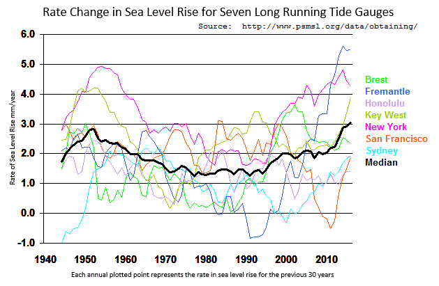
of seven tide gauges from around the world where each plotted point represents the rate of sea level rise for the previous 30 years to illustrate the point.
Following are some excerpts from a US Army Corps of Engineers paper:
“Again, a general trend toward rising sea levels is clearly apparent. All records are highly correlated with respect to some perturbations, particularly the high sea level of the late 1940’s, but not with all perturbations.” [p. 53]
‘The overall national trend is 1.5 dynamic millimeters per year with generally higher values along the mid-Atlantic coast and lower values along the Pacific coast.” [p. 57]
“Continued slow increase in sea level during the last few thousand years may be partially attributable to delayed isostatic response to the loading by higher sea levels on continental shelves.” [p. 58]
“This brief examination of the records for sea level variability in this century and over the past few thousand years demonstrates that the sea level has been changing for as long as any type of records exist. The general trend toward rising sea level at midlatitudes and falling sea level at northern latitudes has been continuing for many centuries. …, there appears little reason for believing that future predictions can be made with great confidence.” [p. 59]
D. L. Harris, 1981, Tides and tidal datums in the United States, Sp. Rpt. No. 7; U.S. Army, Corps of Engineers, Coastal Engineering Research Center, Ft. Belvoir, VA, 382 pp.
“Following are some excerpts from a US Army Corps of Engineers paper:
“Again, a general trend toward rising sea levels is clearly apparent. All records are highly correlated with respect to some perturbations, particularly the high sea level of the late 1940’s, but not with all perturbations.” [p. 53]”
It would make sense that sea levels would be higher back then following the hottest decade in recent times: The 1930’s.
It’s been almost as hot as the 1930’s in recent years, so there is a lot of melting going on now, too.
Except there isn’t much “melting” going on.
Agree.
The two big dogs in the hunt are the East Antarctic ice Sheet, and the Greenland Ice Sheet.
The most recent studies show ice is accumulating on a net basis in Antarctica, and for the past two years at least, Greenland has gained mass as well, as snow fall has been far above average.
Clide Speners last item sums it all up, no one really knows.
But who is advising the men holding the leaverrs of power, what are their qualifications or lack of, and what are their political leanings ?
MJE
Michael … 9:33 pm …
But who is advising the men holding the leaverrs of power…?
If you do a news search on “Sea Level” you will find all sort of people and studies pushing the non-sense. John Englander, you can easily Google him, shows up quite a bit. Here’s a recent story
https://wamu.org/story/18/12/17/sea-level-rise-could-bring-daily-flooding-to-maryland-cities/
Maryland state law apparently requires projections of sea level rise be prepared.
If you do a daily search of Sea Level in the news you will find a daily drone of exaggeration and B.S.
Forgive me if this point has been brought up already. The only major land use change that corresponds approximately with the satellite era is the evaporation of the Aral Sea, which iirc was at one point something like 50 km3. I have no idea how many millimeters of sea level rise that would be, assuming it would be measurable.
50 km^3 = 50E+9 metres^3
Surface area ocean ≈ 3.6E+14 metres^2
Divide volume by surface area, multiply by 1000 to convert to millimeters = about a tenth of a millimeter.
w.
Reckon I got the wrong answer.
I would go with what Willis calculated instead.
But I did some checking, and the Aral sea has lost a lot more than 50 km3.
Closer to 1000 km3.
It used to be 1093 km3, and is now listed as 27 km3, although some sources say it is now increasing again.
Here is one older study.
Current volume of 27 is from Wikipedia, so…
https://link.springer.com/article/10.1007%2Fs13201-012-0048-z
“Aral Sea’s Eastern Basin Is Dry for First Time in 600 Years”
This is a post from a national geographic story, question why was it that dry 600 years ago? If the cause of the Aral drying up is Soviet era river redirecting it makes sense that it dried up now but why then?
Ought to be a straightforward and simple calculation…surface area of the sea/50km3.
Surface area of the ocean is given as about 361.9 million square km (earth is ~510 million sq km x ~70.9% ocean).
So we get 361,900,000km2/50km3 = 7,238,000/km
One million millimeters per kilometer, so looks like 50 cubic kilometers of water would raise the surface of the ocean by a little over 7 millimeters… about 7.23 millimeters.
Late and tired…that may be wrong. I think I have it upside down, but 7 millimeters sounds about right.
I was good at this back when I did algebra every day.
OK, that is the approach I wanted to take. Start with the facts:
1) Mean sea level rise/year: 2.1 mm
2) Radius of Earth (r) : 6,378 km
3) Formula for surface area of a sphere: 4 * pi * r^2
4) Percent of Earth surface covered by ocean: 70.9
5) Volume of shell of water: Sea level Rise * 4 * pi * r2
When I calculate the volume of a shell of water 2.1mm thick on 70.9% of a sphere 6,378 km in radius I get:
~7.6 trillion cubic meters
Can the satellites confirm that that much ice is being melted off the average height of Greenland and the Antarctic every year using the average height change, which should be at least 3 to 4 times (depending on the density) the 2.1mm change in the water level? No sources and sinks!
I believe that volumetric change due to warming of the ocean water column is the reason for a good bit of the rise.
I have wondered if the oceans are still warming at the bottom layers due to the increase in global temp since the end of the Pleistocene glacial max.
Or maybe that ship has sailed and the ocean is warming due to the warmup since the LIA?
I know from field work I have done for one long time employer in years past that for even a small pond in a hot place like Florida, cold water trapped at the bottom by it’s density can stay very cold from year to year, changing only a little from the middle of summer to the middle of winter. This often leads to fish kills when this bottom water is mixed up to the top by high winds, or more commonly the first cold night in the fall or Winter.
Summer heat has a hard time reaching the bottom due to the thermocline(s), of which there may be more than one in deeper ponds and lakes.
(We manufactured equipment to prevent this from occurring, and one of my frequent tasks was doing temp and chemistry [O2, H2S, CH4, etc] profiles of the water columns)
Anywho, if a small pond in Florida still has cold water 12 to 15 feet down in August, how long does it take for an ocean to heat up that is miles deep and it is only hot over part of the surface, and cold in other places all the time…?
We have those Argo things, but how much do they tell us about how the temp has changed over hundreds or thousands of years?
Yes, we have means to determine such things from various chemicals and dead things in the ocean bottom sediments, but how comprehensive are these measurements?
If we have learned one thing, it is that confirmation bias (we all have it, but some have it EXTRA) runs strong in the Dark Side of The Force.
Sorry, that figure is only for the much smaller North Aral Sea remnant. Apparently the whole thing was around 1000 km3 in the 1960s.
Johne Morton wrote:
“ The only major land use change that corresponds approximately with the satellite era is the evaporation of the Aral Sea, …”
Perhaps you are thinking of water surface only, but if so there has been much land world wide brought into irrigation, and while that doesn’t make a lake, it is still water on the land.
Beyond that concept, however, is the fact that “land use” has been changing rapidly as urban areas have grown and changed. Here is an example if one realizes that people need housing, parking, and play and work areas.
The Seattle metropolitan area had a population in 1990 of 2,559,164
In the year 2000 the population was 3,043,878.
2010 => 3,439,809.
2017 => 3,867,046
Those 1.3 M folks required a lot of land use changes.