By Steven Goddard
I found a computer simulation of Arctic ice produced by The University Of Washington, which struck me as being particularly disconnected from reality.
This group is forecasting that September extent will be lower than last year.

Below is their simulation map.

http://psc.apl.washington.edu/zhang/IDAO/seasonal_outlook.html
After watching their map animate, I noticed something which bothered me. They are showing that by August 18, all ice will be gone north of Barrow, AK.

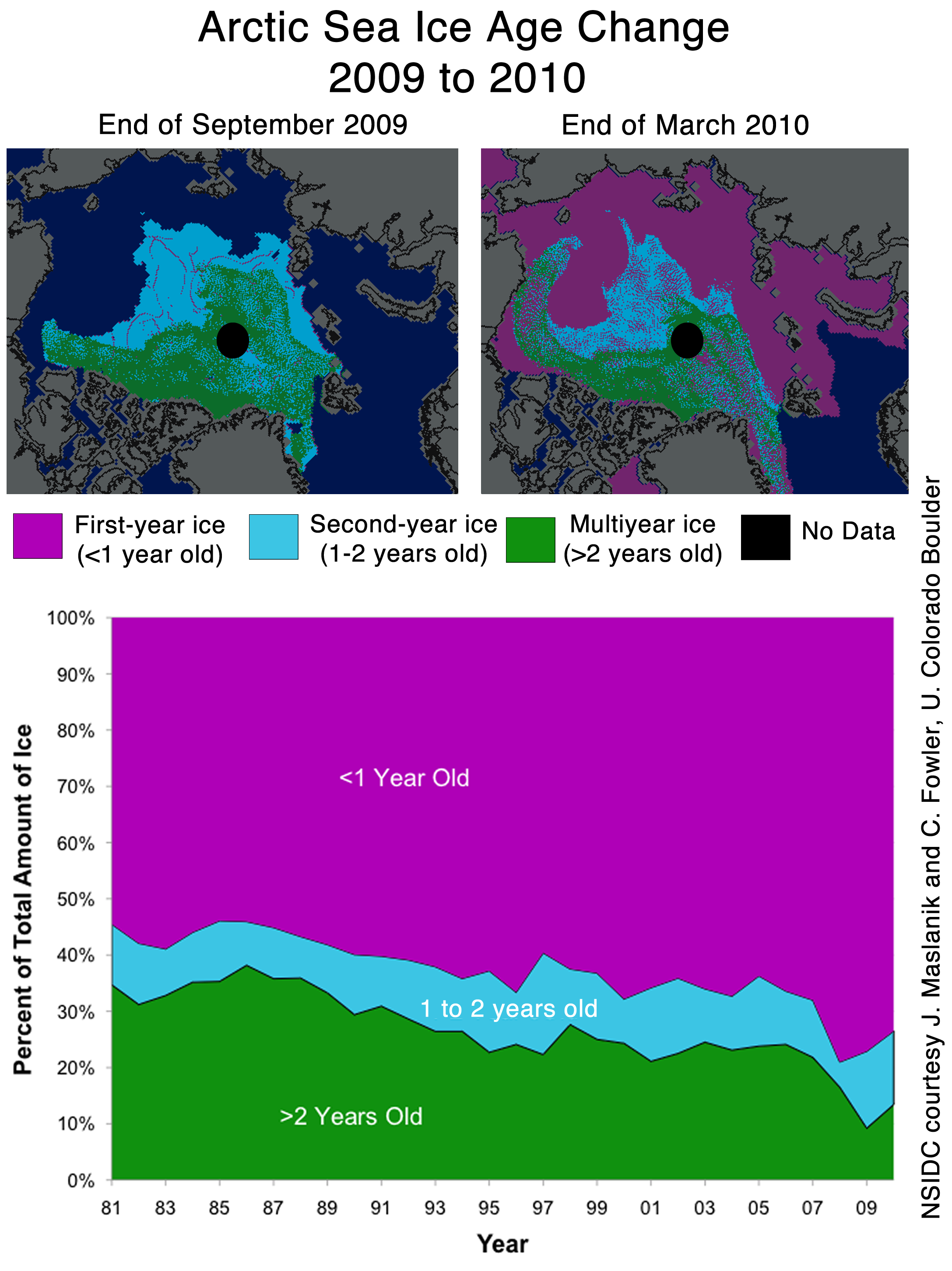
The problem is that NSIDC shows 3+ year old ice in that region:


Cropped from : http://nsidc.org/images/arcticseaicenews/20100406_Figure6.png
The computer model is predicting that 3+ year old ice (which is probably in excess of 10 feet thick) is going to melt by early August. That seems rather far fetched. Below is an overlay of the NSIDC map and the U of W simulation for August 18. Note all the multi-year ice that needs to melt.

Last June, temperatures in Barrow averaged 35F. In July they averaged 44F. It is a tall order to melt 10 feet of ice at those temperatures. This is how Barrow looks today:

http://www.gi.alaska.edu/snowice/sea-lake-ice/barrow_webcam.html
I am a big fan of computer models – when they produce useful information. Garbage in, garbage out.
I don’t entirely blame the modellers. There is no way to get from here to there on such things except by iteration. There just isn’t. However painful it might be on the journey.
It’s the people who try to put more faith in models, particularly immature ones, that deserve the brunt of the raspberries.
Ice thickness in this model is likely entirely made up of ice age. That is a mistaken idea. 1st year ice can be quite thick when jumbled up together along a wind blown ridge, and can be as thick as any other age of ice. I believe the model makes an assumption and uses that assumption to calculate ice thickness, that cannot be supported by hard data.
If they are running the model from say 2003 and it gets the next few years slightly wrong, than in 2010 it would be missing the >2 year ice we know is ACTUALLY there, the model may forecast <1m hence why it melts so easily. Depends if they revise the model each year to match observation or force it from 2009 observed data. As a modellor myself, I know how wrong things can get as your forecast out further and further from a starting point, the small errors get copied and compounded until the result is garbage. I would love to get their 2009 output and compare it with observed and generate some isopachyte contours to show the areas of error!
I am not suprised its wrong though, we cannot forecast ocean currents or wind patterns even a few months out, so how could we get the ice right?
Steven Goddard,
I’m a fan of your Sea Ice posts and was looking at fluid dynamics earlier today to explore the odd pressure changes that occurred from 2003-2006 in the Arctic Ocean.
I ran across some intresting links:
NOAA GFDL: The Shrinking Arctic Ice Cap
“Scientific research conducted at NOAA’s Geophysical Fluid Dynamics Laboratory (GFDL) figures prominently in climate change assessment studies, such as those assembled by the Intergovernmental Panel on Climate Change (IPCC) and the United States Climate Change Research Program (US CCSP).”
Decadal Prediction Can Be Skillful?
Note: (bottom of p. 1476) “The colored regions indicate where the ocean is sensitive to small anomalies, and are thus the optimal regions for initial condition perturbations and for targeted observations to improve forecast skill.”
Decadal Climate Variability, Predictability, and the Atlantic Meridional Overturning Circulation
Maybe I should book that curse after all. Then maybe not. I think a few variables have perhaps the wrong assumptions. Currents, prevailing winds, water and air temperatures among them. The lack of good thickness data is another big problem for any model. I wonder if anyone has told the ice it is supposed to melt? I mean according to Navarra, et al. numeric models rule.
You are forgetting the influence of wind.
At least they don’t show any ice south of the Danish islands in April, as your maps do ….
Last year Zhang et al predicted a September ice minimum of 4.2 million sq km. They had one of the lowest estimates in the Arcus group – all of whom underestimated the total. The actual total 5.4 M sq km was a mere 1.2 M sq km more than Zhang predicted last year. Throwing a dart blindfolded would give about as accurate a prediction as Zhang’s modeling.
http://www.arcus.org/search/seaiceoutlook/2009_outlook/june_report/downloads/pdf/panarctic/2009_Sea-Ice-Outlook_JuneReport_SUMMARY.pdf
http://www.arcus.org/search/seaiceoutlook/2009_outlook/june_report/downloads/pdf/panarctic/1_Zhang_JuneReport_MayData.pdf
If you can’t hindcast with a model, it’s a fantasy game.
Might as well go and study economics or media and talk about stuff, not understand it.
Love yer graphics Steves, but then old sea dogs lubs charts.
In my opinion the melt of multi year ice is possible. The key factor is wind (direction and strength). In that arctic region are clockwise ocean circulation which can transport the ice to other regions. When air temperature is above zero then in stormy sea the melt is much faster the in calm sea at significantly higher temperatures.
The models for longer then 14 days can be used as indicators and not as metrics.
From this site:
http://www.cpc.ncep.noaa.gov/products/precip/CWlink/daily_ao_index/ao_index_ensm.shtml
can see that forecast of AO further then two weeks has big uncertainty.
AO has significant role on Arctic Ice. And if we can’t forecast AO for longer periods than how we can forecast arctic ice ?
The melt scenario got from model shown if this article seems to be possible. But there are lots of other scenarios.
Haralds Rjabovs:
The 60 day drift map shows multi-year ice being transported towards the Bering Strait.
http://iabp.apl.washington.edu/maps_daily_track-map.html
Seems very unlikely that area will be ice free by mid-August.
stevengoddard says:
April 28, 2010 at 10:26 pm
If it’s in the Bering Strait, then it will melt out as the waters are much warmer there. more importantly is that sea ice doesn’t survive the Beaufort Gyre like it used to, so having more multiyear ice in the gyre this year could actually be a bad thing
Leif,
They don’t show any ice in the Baltic Sea, even in March.
I’m not sure why you are giving me credit for generating the NSIDC maps? I don’t have any affiliation with NSIDC.
Leif Svalgaard says:
April 28, 2010 at 10:11 pm
Leif, the reason why the passive microwave shows ice sometimes when it shouldn’t is for two reasons, (1) land contamination results in false ice along coasts (i.e. the coarse spatial resolution of 25km contains both open water and land that will be flagged as ice in the algorithm) and (2) weather can sometimes cause the algorithm to flag a pixel as ice when there is no ice. NSIDC states this clearly in their FAQ and other guide documentation.
How high above sea level does one year ice stand? How come there are so many huge and tall iceberg going south during the melting season? Are those big ones multi-year glaciers?
Keep this posting for posterity:
http://wattsupwiththat.com/2010/04/28/disconnected-computer-modeling/#more-19030
Love to have a look at this posting during this years arctic ice minimum. Then send them a copy of it. (University of Washington). This can be used to end the role of Computer modeling in many areas where it is costing people billions (ie volcanoes iceland drift, climate etc)
That forecast is not surprising. It is very unlikely in my opinion, but it is not imposible. What surprises me is that, according to that graph, in September 2009 there seems to have been less ice than in September 2008. However, as I remember it, I think we got like some extra 500.000 km2 by mid September, when the minimum extent was reached. The graph has to be wrong. Only after the 7th of October or so was the ice in 2009 less than in 2008. This is according to both JAXA and CT. Yet this seems to be based on NSIDC data. I have been unable to find their graphs, or their data to recreate my own graphs, but with such a disagreement with the others…
They could possibly try the tarot, crystal balls, astrology, palm reading, the I ching, or reading the entrails of some poor animal with similar chances of being right…
jeff brown,
Ocean temperatures are very cold south of The Bering Strait this year.
http://weather.unisys.com/surface/sst_anom.html
That does not indicate a lot of melt this summer.
AFP still publishing abolute drivel http://www.google.com/hostednews/afp/article/ALeqM5hm-cVrXpPqxcj7DuOr8gxvYAZbSg
well lets have a look at Arctic temps right here
http://ocean.dmi.dk/arctic/meant80n.uk.php
Nature has not got the message it seems.. people are noticing.
AFP still publishing absolute drivel http://www.google.com/hostednews/afp/article/ALeqM5hm-cVrXpPqxcj7DuOr8gxvYAZbSg
well lets have a look at Arctic temps right here
http://ocean.dmi.dk/arctic/meant80n.uk.php
Nature has not got the message it seems.. people are noticing.
I give them some credit. They have this posted:
Important Notice
The purpose of the seasonal predictions of arctic sea ice is for scientific research and education only.
Some of the best lessons can be learned by being wrong. Mistakes in research …. better education.
stevengoddard says:
April 28, 2010 at 10:32 pm
I’m not sure why you are giving me credit for generating the NSIDC maps? I don’t have any affiliation with NSIDC.
Not for generating them, just for showing them. [or should that be a ‘discredit’ instead?].
Stephan says:
April 28, 2010 at 10:42 pm
“This can be used to end the role of Computer modeling in many areas where it is costing people billions (ie volcanoes iceland drift, climate etc)”
You missed the the wildlife population viability models used by the pseudoscience of Conservation Biology. If you want to ramp up the ‘conservation’ campaign for a variety of reasons (employment, land grabs, whatever) the models predict extinction, or at least semi-doomsday. Just a few little tweaks and a false or stretched assumption or two and its done. And, in the spirit of Orwell, sometimes extinction doesn’t actually mean extinction at all. In one I analysed some years ago called a Vortex model, extinction just meant ANY decline in current numbers! Of course, you had to read the fine print to see that. And, shucks, they forgot to explain that to the fawning media, hungry for a crisis, or the public of course.
Thus the polar bear is only endangered in models, and only in Alaska (EPA) models. Those models just don’t seem to work in Canada or Russia. Different political inputs.
So, indeed, garbage in, garbage out, and some slippery garbagemen – or should I say garbagepersons.
Here is the webcam from Nome AK
http://www.alaskawebcams.org/north.htm