By Steven Goddard
I found a computer simulation of Arctic ice produced by The University Of Washington, which struck me as being particularly disconnected from reality.
This group is forecasting that September extent will be lower than last year.

Below is their simulation map.

http://psc.apl.washington.edu/zhang/IDAO/seasonal_outlook.html
After watching their map animate, I noticed something which bothered me. They are showing that by August 18, all ice will be gone north of Barrow, AK.

The problem is that NSIDC shows 3+ year old ice in that region:


Cropped from : http://nsidc.org/images/arcticseaicenews/20100406_Figure6.png
The computer model is predicting that 3+ year old ice (which is probably in excess of 10 feet thick) is going to melt by early August. That seems rather far fetched. Below is an overlay of the NSIDC map and the U of W simulation for August 18. Note all the multi-year ice that needs to melt.

Last June, temperatures in Barrow averaged 35F. In July they averaged 44F. It is a tall order to melt 10 feet of ice at those temperatures. This is how Barrow looks today:

http://www.gi.alaska.edu/snowice/sea-lake-ice/barrow_webcam.html
I am a big fan of computer models – when they produce useful information. Garbage in, garbage out.
I don’t entirely blame the modellers. There is no way to get from here to there on such things except by iteration. There just isn’t. However painful it might be on the journey.
It’s the people who try to put more faith in models, particularly immature ones, that deserve the brunt of the raspberries.
Ice thickness in this model is likely entirely made up of ice age. That is a mistaken idea. 1st year ice can be quite thick when jumbled up together along a wind blown ridge, and can be as thick as any other age of ice. I believe the model makes an assumption and uses that assumption to calculate ice thickness, that cannot be supported by hard data.
If they are running the model from say 2003 and it gets the next few years slightly wrong, than in 2010 it would be missing the >2 year ice we know is ACTUALLY there, the model may forecast <1m hence why it melts so easily. Depends if they revise the model each year to match observation or force it from 2009 observed data. As a modellor myself, I know how wrong things can get as your forecast out further and further from a starting point, the small errors get copied and compounded until the result is garbage. I would love to get their 2009 output and compare it with observed and generate some isopachyte contours to show the areas of error!
I am not suprised its wrong though, we cannot forecast ocean currents or wind patterns even a few months out, so how could we get the ice right?
Steven Goddard,
I’m a fan of your Sea Ice posts and was looking at fluid dynamics earlier today to explore the odd pressure changes that occurred from 2003-2006 in the Arctic Ocean.
I ran across some intresting links:
NOAA GFDL: The Shrinking Arctic Ice Cap
“Scientific research conducted at NOAA’s Geophysical Fluid Dynamics Laboratory (GFDL) figures prominently in climate change assessment studies, such as those assembled by the Intergovernmental Panel on Climate Change (IPCC) and the United States Climate Change Research Program (US CCSP).”
Decadal Prediction Can Be Skillful?
Note: (bottom of p. 1476) “The colored regions indicate where the ocean is sensitive to small anomalies, and are thus the optimal regions for initial condition perturbations and for targeted observations to improve forecast skill.”
Decadal Climate Variability, Predictability, and the Atlantic Meridional Overturning Circulation
Maybe I should book that curse after all. Then maybe not. I think a few variables have perhaps the wrong assumptions. Currents, prevailing winds, water and air temperatures among them. The lack of good thickness data is another big problem for any model. I wonder if anyone has told the ice it is supposed to melt? I mean according to Navarra, et al. numeric models rule.
You are forgetting the influence of wind.
At least they don’t show any ice south of the Danish islands in April, as your maps do ….
Last year Zhang et al predicted a September ice minimum of 4.2 million sq km. They had one of the lowest estimates in the Arcus group – all of whom underestimated the total. The actual total 5.4 M sq km was a mere 1.2 M sq km more than Zhang predicted last year. Throwing a dart blindfolded would give about as accurate a prediction as Zhang’s modeling.
http://www.arcus.org/search/seaiceoutlook/2009_outlook/june_report/downloads/pdf/panarctic/2009_Sea-Ice-Outlook_JuneReport_SUMMARY.pdf
http://www.arcus.org/search/seaiceoutlook/2009_outlook/june_report/downloads/pdf/panarctic/1_Zhang_JuneReport_MayData.pdf
If you can’t hindcast with a model, it’s a fantasy game.
Might as well go and study economics or media and talk about stuff, not understand it.
Love yer graphics Steves, but then old sea dogs lubs charts.
In my opinion the melt of multi year ice is possible. The key factor is wind (direction and strength). In that arctic region are clockwise ocean circulation which can transport the ice to other regions. When air temperature is above zero then in stormy sea the melt is much faster the in calm sea at significantly higher temperatures.
The models for longer then 14 days can be used as indicators and not as metrics.
From this site:
http://www.cpc.ncep.noaa.gov/products/precip/CWlink/daily_ao_index/ao_index_ensm.shtml
can see that forecast of AO further then two weeks has big uncertainty.
AO has significant role on Arctic Ice. And if we can’t forecast AO for longer periods than how we can forecast arctic ice ?
The melt scenario got from model shown if this article seems to be possible. But there are lots of other scenarios.
Haralds Rjabovs:
The 60 day drift map shows multi-year ice being transported towards the Bering Strait.
http://iabp.apl.washington.edu/maps_daily_track-map.html
Seems very unlikely that area will be ice free by mid-August.
stevengoddard says:
April 28, 2010 at 10:26 pm
If it’s in the Bering Strait, then it will melt out as the waters are much warmer there. more importantly is that sea ice doesn’t survive the Beaufort Gyre like it used to, so having more multiyear ice in the gyre this year could actually be a bad thing
Leif,
They don’t show any ice in the Baltic Sea, even in March.
I’m not sure why you are giving me credit for generating the NSIDC maps? I don’t have any affiliation with NSIDC.
Leif Svalgaard says:
April 28, 2010 at 10:11 pm
Leif, the reason why the passive microwave shows ice sometimes when it shouldn’t is for two reasons, (1) land contamination results in false ice along coasts (i.e. the coarse spatial resolution of 25km contains both open water and land that will be flagged as ice in the algorithm) and (2) weather can sometimes cause the algorithm to flag a pixel as ice when there is no ice. NSIDC states this clearly in their FAQ and other guide documentation.
How high above sea level does one year ice stand? How come there are so many huge and tall iceberg going south during the melting season? Are those big ones multi-year glaciers?
Keep this posting for posterity:
http://wattsupwiththat.com/2010/04/28/disconnected-computer-modeling/#more-19030
Love to have a look at this posting during this years arctic ice minimum. Then send them a copy of it. (University of Washington). This can be used to end the role of Computer modeling in many areas where it is costing people billions (ie volcanoes iceland drift, climate etc)
That forecast is not surprising. It is very unlikely in my opinion, but it is not imposible. What surprises me is that, according to that graph, in September 2009 there seems to have been less ice than in September 2008. However, as I remember it, I think we got like some extra 500.000 km2 by mid September, when the minimum extent was reached. The graph has to be wrong. Only after the 7th of October or so was the ice in 2009 less than in 2008. This is according to both JAXA and CT. Yet this seems to be based on NSIDC data. I have been unable to find their graphs, or their data to recreate my own graphs, but with such a disagreement with the others…
They could possibly try the tarot, crystal balls, astrology, palm reading, the I ching, or reading the entrails of some poor animal with similar chances of being right…
jeff brown,
Ocean temperatures are very cold south of The Bering Strait this year.
http://weather.unisys.com/surface/sst_anom.html
That does not indicate a lot of melt this summer.
AFP still publishing abolute drivel http://www.google.com/hostednews/afp/article/ALeqM5hm-cVrXpPqxcj7DuOr8gxvYAZbSg
well lets have a look at Arctic temps right here
http://ocean.dmi.dk/arctic/meant80n.uk.php
Nature has not got the message it seems.. people are noticing.
AFP still publishing absolute drivel http://www.google.com/hostednews/afp/article/ALeqM5hm-cVrXpPqxcj7DuOr8gxvYAZbSg
well lets have a look at Arctic temps right here
http://ocean.dmi.dk/arctic/meant80n.uk.php
Nature has not got the message it seems.. people are noticing.
I give them some credit. They have this posted:
Important Notice
The purpose of the seasonal predictions of arctic sea ice is for scientific research and education only.
Some of the best lessons can be learned by being wrong. Mistakes in research …. better education.
stevengoddard says:
April 28, 2010 at 10:32 pm
I’m not sure why you are giving me credit for generating the NSIDC maps? I don’t have any affiliation with NSIDC.
Not for generating them, just for showing them. [or should that be a ‘discredit’ instead?].
Stephan says:
April 28, 2010 at 10:42 pm
“This can be used to end the role of Computer modeling in many areas where it is costing people billions (ie volcanoes iceland drift, climate etc)”
You missed the the wildlife population viability models used by the pseudoscience of Conservation Biology. If you want to ramp up the ‘conservation’ campaign for a variety of reasons (employment, land grabs, whatever) the models predict extinction, or at least semi-doomsday. Just a few little tweaks and a false or stretched assumption or two and its done. And, in the spirit of Orwell, sometimes extinction doesn’t actually mean extinction at all. In one I analysed some years ago called a Vortex model, extinction just meant ANY decline in current numbers! Of course, you had to read the fine print to see that. And, shucks, they forgot to explain that to the fawning media, hungry for a crisis, or the public of course.
Thus the polar bear is only endangered in models, and only in Alaska (EPA) models. Those models just don’t seem to work in Canada or Russia. Different political inputs.
So, indeed, garbage in, garbage out, and some slippery garbagemen – or should I say garbagepersons.
Here is the webcam from Nome AK
http://www.alaskawebcams.org/north.htm
Has anyone noticed that the same computer modeling techniques and “quant-types” predicted that sub-prime mortgages were safe?
The irony is delicious. Wall Street models = Enviro models.
The computer model is predicting that 3+ year old ice (which is probably in excess of 10 feet thick) is going to melt by early August. That seems rather far fetched.
Not really, it’s fragmented ice so has high surface area exposure and will likely melt like it did in 2007.
http://wattsupwiththat.files.wordpress.com/2009/04/arctic_amsr-e_flow_animation-40.gif
Also that ice is drifting away at ~10km/day.
Ray says:
April 28, 2010 at 10:35 pm
How high above sea level does one year ice stand? How come there are so many huge and tall iceberg going south during the melting season? Are those big ones multi-year glaciers?
Calving from glaciers not sea ice.
Whoa. That is removed from reality. There is NOTHING in the present weather or solar patterns that would indicate a sustained above 32degree atmospheric/oceanic temperature. And I do nor believe you could melt that much ice without a cataclysmic cause. This would be unprecedented.
The European research (?) project DAMOCLES (!) for two years now has a competiton, which model gives the best prediction of the September arctic sea ice minimum (kind of Europe’s next Top Climate Model). And guess what, in 2009they all were wrong (you can guess as well, in which direction they failed). I think in 2010 they will have this competition as well. It will be interesting to see, if teir guesses are any better this year…
Anyone got a link for sea ice data series that go back to 1979?
I’ve been looking for such a series, but so far, all the sources, such as cryo, dmi, nansen, nersc, hide their series data. Only jaxa openly provide data but that only goes back to 2002.
Looking like we’ll need another round of FOI requests.
@meemoe_uk:
ftp://sidads.colorado.edu/DATASETS/NOAA/G02135/
Here’s what we get fed here in Australia about Arctic ice;
http://www.smh.com.au/environment/climate-change/melting-ice-makes-the-arctic-a-vicious-circle-20100429-tssb.html
“The amount of Arctic sea ice was at a record low in the summer of 2007, down about 40 per cent.
Although it has recovered slightly since, the long-term trend is down, he said. “We’re heading towards a situation where the Arctic Sea will be ice-free in summer.”
Bastardi also predicting a Arctic ice low this year. He also says it will rebound in the next few years to unseen levels, so while the Warmists may cheer that their theories are correct by Xmas, they will be silent in the coming years.
More fun with ice!. The tipping point is getting nearer at the Nenana Ice Classic. http://www.nenanaakiceclassic.com/
Ummm… I have written my fair share of simulations. Look even when you have ALL the variables accounted for predicting something like ice loss or other complex systems is rough. What these researchers are really relying on is linear regression and then extending it out to the future. Because in the end that is all you can do in a case like this.
A simple example of a simulation is a coin flip. Now after 10,000 flips the model will be about 50/50 though in reality it is usually weighted 51.5 to 48.5
Even then it does not tell me what the next coin flip will be. Now you can say that modeling the behavior of something is different. And it is to a limited extent. But in the end because you do not have all the variables ultimately you rely on trends to truly model from. This is where danger lies in any model. A trend is just that, a trend. If I break down the controlled experiment of a coin toss and I have just had 6 heads in a row would I then expect the next flip to be a head or a tail? Even in accounting for all the variables in a coin flip ( there are two ) you cannot predict with accuracy the next toss. Now you can predict that the next toss will be either a head or a tail with a fairly large degree of certainty. I.e. I predict that there will be arctic ice loss in August. But to model this and claim anything until it has happened is a little silly. In other words after 2 decades of them internally making a prediction and then their being correct 95% of the time I would lend credence to a prediction. Short of that it is hypothesis and while interesting if repeated 20 – 100 times ( again with the 95% accuracy ) then I will pay attention. This prediction via modeling is not really worth mentioning as until it is proven to be accurate.
hi,
in fig. 1 i cannt see the extent in 09 2010 lower than 2009!
Well, if anything this is a forecast that can be “validated” within a few months. Garbage out.
gg
How come there are so many huge and tall iceberg going south during the melting season?
Icebergs come from glaciers. And the more snow there is, the more icebergs there will be, because there is more bulk of snow and ice pushing the bits to break off. Icebergs are not directly related to melting due to heating of the earth. (Warming without extra snow to compensate will cause the glaciers to retreat, not calve more.)
But I suspect you know that already. Either that or [snip]
One way of testing the validity of the models is to look at past performance. The SEARCH predictions, from some of the most expert Arctic scientists, which were based on July 2009 data failed miserably to get it right. The lowest estimate out of the 14 predictions was 4.2 million square kilometres and the highest was 5.0 with an actual of 5.36 million square kilometres.
http://www.arcus.org/search/seaiceoutlook/2009_outlook/august_report/downloads/graphs/augustreport_julydata_chart_preview.png
Clearly we have much to learn before long-term estimates give meaningful results.
OT: News – Gas breakthrough promises to slash solar industry’s climate impact
It may have a reputation as one of the greenest industries around, but the solar sector is also directly responsible for emissions of one the world’s most potent greenhouse gases.
Manufacturers of photovoltaic solar panels, computer chips and flat-screen TVs typically use production processes that make use of a gas called nitrogen trifluoride (NF3) to clean the machines used for chemical deposition processes. However, while NF3 is only used in relatively small quantities, it has a global warming impact that is 17,200 times greater than carbon dioxide.
http://www.businessgreen.com/business-green/news/2262226/gas-breakthrough-promises-slash
Odd! But that’s what “businessGreen” says! What next? Will someone tell us that grass isn’t green?
Perhaps you should discuss the model inputs are before passing judgement.
Calving is ice buildup not melting.
Shit even Pirates know that, means top of the world is too cold for safe passage.
Shit we used to ferry Vikings and tow Longboats.
And the odd Roman on the other side the odd Kahn and pony.
Seems no one learns Pirate history, anymore.
I dont know what your point bringing up Barrow ice melt in relation to the models. If you look at the yearly series of images on the Barrow webcam site you’ll see that there is consistently open ocean north of Barrow by mid-July, so open ocean by August isnt a big feat. Hell, even when I was in Barrow in April 2008, large portions of open water had already begun to open up north of Barrow.
It’s possible for predictors to bet on whether this year’s minimum arctic ice extent will be greater than last year’s. The rules are given here, and contain a link to the bet-page:
https://bb.intrade.com/intradeForum/posts/list/4474.page
The last bet was at 50% odds.
meemoe_uk says:
April 29, 2010 at 12:26 am
Anyone got a link for sea ice data series that go back to 1979?
This is a seasonal sea ice extent timeseries. It starts at 1870 and the last full year is 2007 How accurate it is I will leave you to judge. There is no explanation of what the column values indicate but I have looked at it and calculated that column 1 is the year average. I’m assuming that the other columns follow seasonal conventions.
Winter DJF col 2, Sping MAM col 3. Summer JJA col 4, Autumn SON col 5
http://arctic.atmos.uiuc.edu/SEAICE/timeseries.1870-2008
Source page.
http://arctic.atmos.uiuc.edu/SEAICE/
Craigo says:
April 29, 2010 at 1:23 am
More fun with ice!. The tipping point is getting nearer at the Nenana Ice Classic. http://www.nenanaakiceclassic.com/
—
Now there is some real data!
http://www.nenanaakiceclassic.com/Ice%20Measurement.htm
Never heard of Nenana Ice, guess the pot goes to those who get closest to the date and time, right?
Just scanning, seems 2010 is really one of the coldest years for the last 20 years, over 50 inches of ice and so far days still clicking. Thanks for something new!
I told you before has any body told the polar bears about this thay have been relying on Al Gore for there travel plans
Anthony, check this video out http://www.blip.tv/file/3539174
Leif Svalgaard
You seen to have a perpetual problem with Steven using NSDIC maps. Perhaps you can refer us to what you consider an authoritative source of information on ice extent/coverage.
Hopefully not too OT.
Very interesting. As I write the ABC (Australia) is showing a science based show (Catalyst), this week dedicated to the Antarctic. The main interviewees are scientists from the Antarctic Division of the CSIRO and James Hansen of NASA. Melting,thinning,acidification and tipping points all get a run. AGW is to blame without doubt. Warm currents and thin shelled pteropods prove a disaster is imminent.
Now maybe they are right but the CSIRO and James Hansen have been so compromised in the past on the AGW/CC issue one wonders where the truth lies. Please help me out.
My model predicts that by the end of the 2010 melt season the number of worthless layabouts investigating the effects of AGW on – almost anything! – will have fallen to it’s lowest level this century. The possible slow motion meltdown of the Euro and the likely decline in world trade that might then occur could result in national governments facing a projected reluctance on the part of investors (to one std of course) to bail out nations that could be identified by a secret algorithm as multi-year debtors , whilst those debtors of barely one years standing may feel the heat much sooner, and may have a statistical chance of becoming toast.
Let’s see whose prediction is more correct in September.
I think my model (5’6″, 36-24-36, and blonde with a gsoh) has more chance than than Washington Uni.
Mike Haseler says:
April 29, 2010 at 1:46 am
BE GREEN, boycott solar panels! Not only is nitrogen trifluoride (NF3) 17,200 times more potent GHG than CO2 but also plants don’t live on it and convert it to O2. Another great GREEN industrial product to save the world, just ignore the manufacturer’s footprint and where it goes when it’s broken! (Mike, thanks for the info)
In fact, I wonder what it’s half-life time in the atmosphere is?
@Juraj V.
Thats no good, and is typical of the data given by all the ice authoritys. Discontinuous, and in map form. Time series is what everyones after.
Wonder if Goddard has got any, he seems to be one of the top ice men round here.
Let me guess, they get their grant money from the government …
It is getting to be an old joke, Anthony, but the warmaholics have redefined GIGO. For warmaholics GIGO means Garbage In, Gospel Out. I hope SEARCH is going to run it’s survey of model outputs for September 2010.
Ray says:
April 28, 2010 at 10:35 pm
As I understand it, and only from those more learned than me here, so don’t call me on it, icebergs are from glaciers, not sea ice. They will, therefore, be a great deal larger than sea ice may be (generally).
Graigo: Wonder what Phil and De Witt pain have to say about that
http://www.nenanaakiceclassic.com/Ice%20Measurement.htm
Looks like its all over the place confirming that its got absolutely nothing to do with ice status at minima or maxima extent or more or less ice melting etc.
Wonder if its real data though….
Phil,
You linked to a video which started in October, 2007 and claimed it showed 2007 melt.
http://wattsupwiththat.files.wordpress.com/2009/04/arctic_amsr-e_flow_animation-40.gif
Nice try.
This post concerns PIOMAS, which is used to generate the terrifying anomaly graph the CAGW Crowd have been waving around to PROVE there is a horrendous ongoing loss of Arctic sea ice VOLUME with a definitive downward trend.
http://psc.apl.washington.edu/ArcticSeaiceVolume/images/BPIOMASIceVolumeAnomalyCurrent.png
And now we can see the problems of the PIOMAS model, besides all the other assumptions made in estimating (read: guessing with computers) the ice thickness and thus the ice volume.
Nice work, Steven.
I think that there is a considerable tendency to falsely equate ‘Atmospheric Temperature’ with ‘Atmospheric Heat Content’ this is because it is an easier metric. However, a negative NAO leads to a large drop in moisture flux North of 70-degrees and this will result in a drop of atmospheric heat content (due to reduced enthalpy) in the Arctic for a particular temperature. It is the available heat energy that melts the ice not the air temperature. From the Unisys SST anomaly maps there does not appear to be as much heat content in the oceans just outside the arctic as normal either.
Perhaps the models are using the wrong proxies for available heat energy?
Leif,
Finally, I understand Hamlet.
“Something (ice) is rotten in the state of Denmark.”
Before posting next week’s edition, I promise to personally traverse the entire Arctic on foot, and make sure that NSIDC doesn’t show any stray ice pixels.
Mauibrad: probably best video ever on the issue. A must definitely
http://www.blip.tv/file/3539174
Clear law violations or intent to violate law with proof
DMI ice wild swing up again!
http://ocean.dmi.dk/arctic/icecover.uk.php
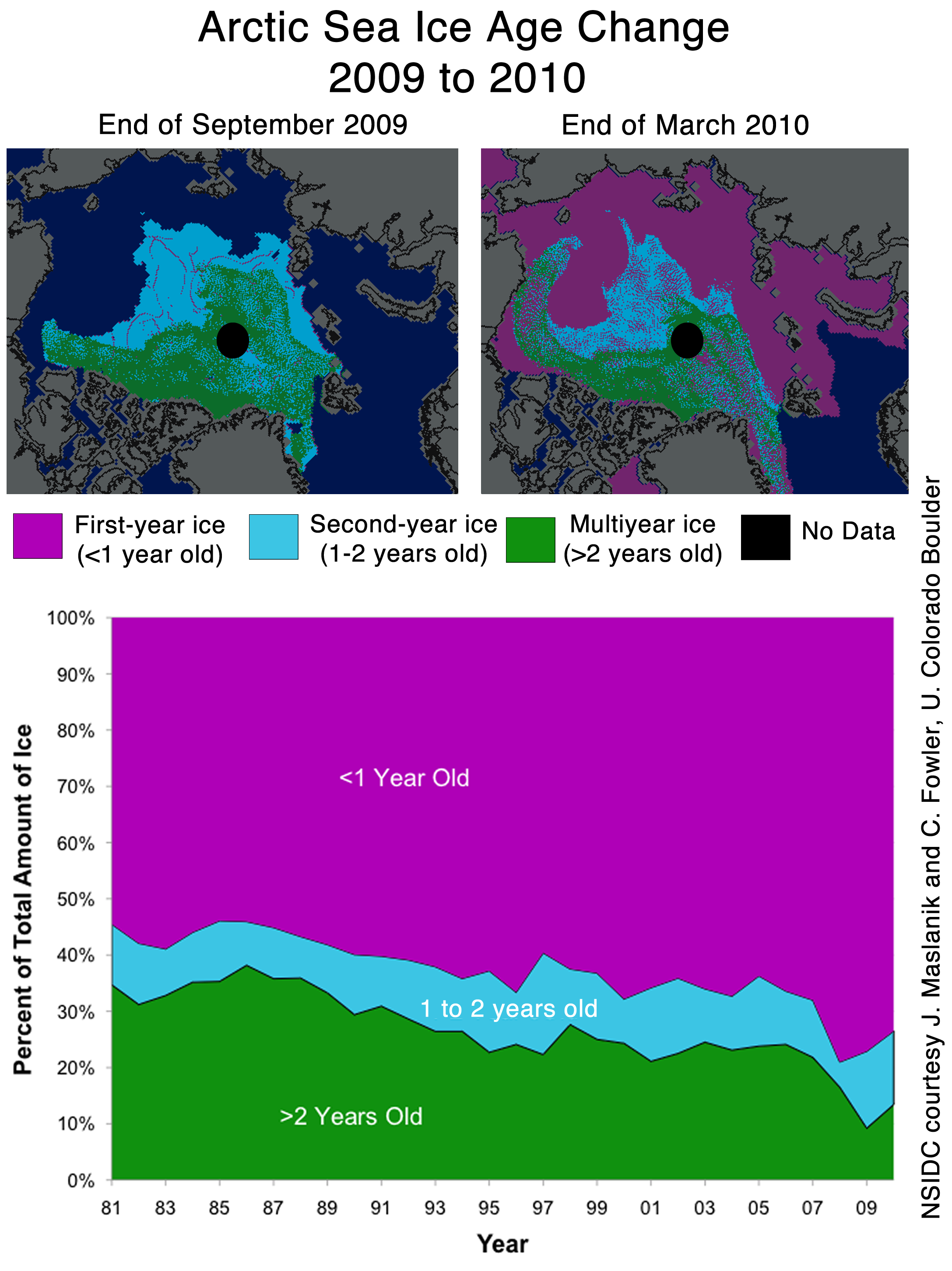
Arctic sea ice age, april 2009 vs. february 2010. More multiyear sea ice than a year ago: http://img408.imageshack.us/img408/6951/image001hw.png
http://soa.arcus.org/sites/soa.arcus.org/files/sessions/2-1-observations-arctic-change/pdf/2-1-3-tschudi-mark.pdf
Lawrie Ayres says:
April 29, 2010 at 3:36 am
. . . . . .
Please help me out.
It’s really quite simple Lawrie, unless you’re comfortable with that sort of entertainment and with making the correct utterances, you see that ‘off’ button there . . .
OT News: 21% would give up sex to stop climate change
21% of total respondents would be willing to give up sex for “one year or more” if they could stop climate change (10% of women would be willing to do so forever vs. 3% of men)
15% of respondents would be willing to give up their spouse for “one year or more” and 11% would be willing to do so forever
http://www.thegreenworkplace.com/
http://www.earthtimes.org/articles/show/would-activists-give-up-sex,1272743.shtml
How wonderful it is that so many global warmers would give up sex to save the planet, surely an inspiration to others! A pity their parents didn’t share the same noble ideas!
Nick says: (April 29, 2010 at 1:57 am)
“Perhaps you should discuss the model inputs are before passing judgement.”
This model can only predict what may happen IF the conditions programmed into it actually do come about. What are those conditions and what is the probability that those conditions will prevail?
Mike Haseler says: (April 29, 2010 at 5:51 am)
“15% of respondents would be willing to give up their spouse for “one year or more” and 11% would be willing to do so forever”
Probably true without any conditions attached!
The NOAA has this link of the predicted ice extent minimum for 2009 by 16 individual scientists/models (and they were all too low even though the predictions were made in July, 2009) (3 of the scientists are from the Polar Science Centre and they got the prize for 1st, 2nd and 4th worst predictions. )
http://www.arcus.org/search/seaiceoutlook/2009_outlook/minimum/downloads/pdf/minimum-july-comparison-2009.pdf
[The ones done in June were even farther off].
From Mike Haseler on April 29, 2010 at 5:51 am:
How wonderful it is that so many global warmers would give up sex to save the planet, surely an inspiration to others! A pity their parents didn’t share the same noble ideas!
Considering what I’ve heard that the teenagers and young adults consider to be “not really sex,” I wonder if it was clearly specified they’d be giving up all of that. Perhaps they should bring in Dr. Ruth to explain that should also include the self-service option. And going by “that Seinfeld episode,” could people give up to fight “global warming” what they couldn’t even give up for money?
It goes back to the old saying: To err is human. “To really foul things up requires a computer.”
Or more precisely, to really foul things up requires a computer mindlessly cranking out results based on only understanding half of the picture. This was recognized decades ago, before we applied the term “modeling” to it.
Then if the program was written by volunteers, there is often no good way to add new factors without re-writing a bunch of it. So the owner, not having the budget to fix the problem, is forced to defend the indefensible.
@MartinGAtkins
Thks, I found that one too, and was going to puzzle over it, but then thought – this is absurd! We shouldn’t have to put up with these artifically poor data sets. All the graphs for dmi, nansen, cyro , nsidc are based on daily data points.
Gotta look for better data sets.
The presumption appears to be that the intention is to project the extent of ice rather than to provide support for the military planners of several nations who propose to demonstrate sovereignty in the area by establishing regular patrols in an ice-free arctic. Patrols requiring new ships, fuel, provisions, emergency planning etc. A strategy that would no doubt add to the wealth of companies who provide such things to the military and elevate the status of the officers in charge of such operations. Forgive me, I’m just an old cynic.
Peter Plail says:
April 29, 2010 at 3:21 am
You seen to have a perpetual problem with Steven using NSDIC maps.
Don’t know of any better [haven’t looked hard, though], but it would seem that NSDIC are the ones with the problem. Perhaps the lesson is to realize that there are uncertainties that may at times be greater than the apparent changes, so not to read too much into small differences.
Mike Haseler,
“OT News: 21% would give up sex to stop climate change
21% of total respondents would be willing to give up sex for “one year or more” if they could stop climate change (10% of women would be willing to do so forever vs. 3% of men).”
Reminds me of the comic book guy in an episode of the Simpsons, who, when dictating that procreation would take place once every seven years, mused “for me, this will mean a lot more sex.”
Capn Jack says: If you can’t hindcast with a model, it’s a fantasy game.
Hindcasts are little more than curve-fitting. I’d say that if you can’t predict going forward with a model, it is a fantasy game.
I say so what if there does happen to be more open water up there. It’s good for the polar bears — more sunlight on the water means more phytoplankton primary production, which eventually means MORE POLAR BEARS (along with every other living thing in that food web). Capn Jack’s brothers will be fightin ’em off with longboat oars. I want a white bearskin rug. The Gore-ist Gullibles should be glad that more CO2 might be at least temporarily sequestered in the increased biomass.
Chances are next years you would have to worry about the extension of ice ON continental areas, that will be much more interesting. For sure, Catlin´s expedition members will set up a new expedition, perhaps to travel from NY to Washington state along the new glaciers….
It is as though they know nothing about the actual thing they are simulating. I would not be surprised to discover that they have never been there. But if you asked them, they would probably come back with a defensive arguement such as, “well, do you expect modellers of the Sun to have been to the Sun”. Seriously, this is the level of these “researchers”.
Do not try to model the Northern Ice unless you have been there, touched it, tasted it, for a whole annual cycle, and understood the power of the cold, and the wind, that you are nullifying in your silly little model. in fact, you should relocate there and conduct your research in situ – then you would not make such a silly mistake.
diablobanquisa says:
April 29, 2010 at 5:39 am
Arctic sea ice age, april 2009 vs. february 2010. More multiyear sea ice than a year ago: http://img408.imageshack.us/img408/6951/image001hw.png
Not really since the two images are not for the same time, the one for 2010 is 9 weeks earlier and so misses a consistent outflow through the Fram of about 60km/week.
stevengoddard says:
April 28, 2010 at 10:49 pm
jeff brown,
Steve, that changes in summer. Look at http://www.arctic.noaa.gov/report08/ocean.html
meemoe_uk says:
April 29, 2010 at 12:26 am
NSIDC has Arctic sea ice data back to 1972 from satellite. The Had1SST data set gives it back to 1900.
stevengoddard says:
April 29, 2010 at 5:16 am
Leif, Finally, I understand Hamlet.
You understand Hamlet? Wow! Your even better than I thought!
et. al.,
It’s not the humidity %.
It’s not the air temperature.
It’s not the water temperature.
It’s not the wind direction or speed.
It’s not the ocean currents/circulation.
It’s not the average cloud cover in July.
It’s not how much it snows on the ice in June.
It’s not the degree of change in barometric pressure.
It’s ALL of the above, and each has a maximum degree of effect, air temp. being one of the least. AND ALL (to a significant degree) unpredictable between 3 days from now and August. UW’s prediction is a seat-of-the-pants guess, probably “designed” to get attention and more funding OR to JUSTFY the expenditure of some already awarded grant funds. Could it happen? Sure. Do current conditions lean in that direction? No, but that could change in a day or two.
BTW, the “Ice Thickness Chart” R.Gates has linked to a number of times is also from UW, but I can not find any real world confirmation data (raw or other wise) supporting it’s creation. It appears to be 100% computer model generated based entirely on assumptions.
http://psc.apl.washington.edu/zhang/Global_seaice/model.html
Satellite sea ice concentration data are assimilated in GIOMAS using the Lindsay and Zhang (2005) assimilation procedure. The procedure is based on “nudging” the model estimate of ice concentration toward the observed concentration in a manner that emphasizes the ice extent and minimizes the effect of observational errors in the interior of the ice pack.
I wonder if they told the data – Resistance is futile. You will be assimilated.??
Slightly OT, but are there any comparison runs of how far off the models have been in the last 20 years to what was physically observed, and would somebody point me to where those might be?
Just unplug it and save the planet!
The fallacies of the imprudent if left unchecked, uncontested and uncorrected will damage the credibility of the whole modeling gamut. Myself, being an ordinary person trying to make a decision, am hovering in limbo until ‘scientific’ theories become confirmed and certified factual indicators. There are clearly ulterior motives at work in some of the persons allowed to influence the public and to the untrained eye it is impossible to know who is misrepresenting the data. Should I flip a coin or will someone in your area of expertise stand up and call a spade a spade?
Dr. Svalgaard raises a valid point. Using the NSIDC info to call into question the U of W model, seems to require taking a stand on the validity of the NSIDC chart, not a surly tap dance about traversing the Arctic. That sort of rhetorical device is something warmists often employ to deflect.
Milwaukee Bob says:
April 29, 2010 at 7:44 am
Bob, you are right that it is all of those things, and that is why even though a thin ice cover may imply more ice loss in summer, the summer weather patterns still play a crucial role in shaping the end-of-summer ice cover. But what the PIOMAS model is doing in Lindsay and Zhang’s 2005 study is very appropriate for simulation of the ice cover. That is how climate forecasting can be improved, by using actual data to force the models, and not climatologies. It’s what your weather predictions do. But of course, we don’t know what the summer weather is going to be, so there’s a limit on predictability.
But if you evaluate climate model output (which you can do by downloading data from CMIP3), you will find that as the ice cover thins, you reach a point where the summer weather patterns are no longer as important and predictability of summer ice cover based on knowledge of the winter ice cover improves. Obviously the Arctic ice cover is still strongly influenced by the summer weather patterns which is why predictions for 2009 were so far off.
Don’t forget that the Russians have a fleet of nuclear powered ice breakers that will make 10 knots through 8-9 feet of ice, use them for clearing the shipping lanes above Siberia (where the ice melts first in the summer, and even for holidays to the north pole.
What is the effect on sea ice in the summer and the deposition of precipitation build-up? How about reduction in albedo of open ocean? Ice formation in the winter (max area-min area) is about at normal 30-year levels. I think I saw annual mileage of 30,000, but can’t find the reference. Other countries have ice breakers and many have ice breaking ships.
Thanks for your good work, all!
http://www.victory-cruises.com/arctic.html
http://www.youtube.com/watch?v=g4RQXkI3B8w&feature=related
What a pity to get petty..
Craig Moore
I have never seen any evidence that NSIDC data is significantly incorrect. I once wrote about an apparent discrepancy between NSIDC and UIUC, and it turned out the problem was mainly on the UIUC side.
Capn Jack, you used to do what to the Vikings? I hope that has nothing to do with your mizzin mast, …… 8^D
stevengoddard says:
April 29, 2010 at 8:30 am
NSIDC’s sea ice extent data can be incorrect near the coasts (land contamination) and near the ice edge from weather effects. They can also underestimate new, thin ice because the algorithm used assumes snow on the ice. That is why ice chart data is the most accurate since they also incorporate radar and visible imagery as well as in situ observations into their charts. Perhaps you should use data from NIC or the Canadian ice service instead?
Leif Svalgaard says:
April 29, 2010 at 6:57 am
There are small differences and then there are gnat’s *ss differences. That smudge of white you’re pointing at. . . is it even as much as .001% of the total?
All-
Microsunspot 1063 just appeared, and we now have a sunspot count of 12. Since suspots play a role in the global warming debate, does anyone have any data on whether these microsupots are being “over-read” essentially increasing the sunspot number? 1063 is barely there!
Fred Chopin
Excellent point about icebreakers. That may well be contributing to recent low summer minimums, by exposing more ice surface area to the sun and the water.
At the end of August we will have the empirical data that will either support or refute their computer generated forecast. I wonder if they will admit error if their model proves to be wrong? Or, I wonder what lame excuse they will come up with if they are unwilling to admit error? If they turn out to be right, they’ll deserve congrats!
kadaka, it was interesting that 10% of women and 4% of men said they would “give up sex forever” to save the planet.
I wonder what the response would have been if the question would have been: “would you give up having children”?
And why wasn’t that obvious question raised? Reducing fossil fuel use per person AND reducing the number of people would be equally viable ways to “tackle global warming” (as they put it). So why is it that the former and not the latter is always top of the warmer’s agenda?
Have you noticed that “tackling global warming” always involves giving up “boys toys” like cars, planes etc. But it never involves giving up “girls toys” (i.e. babies)? If the debate were rational (which it clearly isn’t) then anyone could see that if you wanted to reduce overall fossil fuel use, then you could achieve this without any impact on (mankind’s) standard of living if you cut population by the required percentage. And whilst there is obviously a natural limit to the rate of reduction – any such reduction would have minimal impact of anyone who is alive today.
So, it seems to me that there is clearly a very anti-male sexual bias amongst the global warming brigade. What after all is trying to save “mother earth” other than part of a much wider female conspiracy to feminise even the planet we live on!
Put it this way, given a straight choice between:
A) No car and no sex with all the babies (and nappies/diapers?) you could ever want,
B) A car and as much sex as you like without the hassle of babies.
… as for the “precautionary approach” …. I could go on but I’ve got to cook dinner!
As pointed out earlier, Zhang way underpredicted the sea ice extent last year. In fact, if we take this into account, the sea ice extent minimum should actually come in around 6.4 M sq. km. (rather than 5.3).
Hmm…. the trolls are back with thier half-truths warning of impending catastrophic melting in the Arctic.
Must have been a bad day in Congress when immigration sent Climate Change to the back of the line.
Read your AMA Journals for sea ice and iceberg conditions 1880’s-1920’s. With all those years of icebergs emptying out of the Arctic, you’d think the place would have been ice-free 90 years ago. Not to mention Greenland would have tipped over and spilled it’s glaciers and cap, raising sea levels catastrophically.
If I had to guess, I don’t think icebreakers would have much effect on ice melt. Most of that now fractured ice is still covering the surface and so most of the albedo will still be intact.
But I am eager to be proven wrong. This is a study that could very easily be undertaken by a high school kid for a science fair project using heat lamps in a refrigerator and prepared pans full of set volumes of pre-frozen ice. Any takers?
“”” jeff brown says:
April 28, 2010 at 10:35 pm
Leif Svalgaard says:
April 28, 2010 at 10:11 pm
Leif, the reason why the passive microwave shows ice sometimes when it shouldn’t is for two reasons, (1) land contamination results in false ice along coasts (i.e. the coarse spatial resolution of 25km contains both open water and land that will be flagged as ice in the algorithm) and (2) weather can sometimes cause the algorithm to flag a pixel as ice when there is no ice. NSIDC states this clearly in their FAQ and other guide documentation. “””
So if I understand your post their sampling doesn’t account for anything smaller than 625 squ km properly.
I thought space cameras were supposed to be able to read licence plates on cars; or at least tell there is a plate. Hell I would be happy if they could just tell there’s a car there; but evidently they can’t even tell if there’s a shopping mall there.
“”” ← EPA’s action Jackson moving forwardDisconnected Computer ModelingPosted on April 28, 2010 by Anthony Watts By Steven Goddard
I found a computer simulation of Arctic ice produced by The University Of Washington, which struck me as being particularly disconnected from reality.
This group is forecasting that September extent will be lower than last year.
Below is their simulation map.
http://psc.apl.washington.edu/zhang/IDAO/seasonal_outlook.html
After watching their map animate, I noticed something which bothered me. They are showing that by August 18, all ice will be gone north of Barrow, AK.
The problem is that NSIDC shows 3+ year old ice in that region:
Cropped from : http://nsidc.org/images/arcticseaicenews/20100406_Figure6.png
The computer model is predicting that 3+ year old ice (which is probably in excess of 10 feet thick) is going to melt by early August. That seems rather far fetched. Below is an overlay of the NSIDC map and the U of W simulation for August 18. Note all the multi-year ice that needs to melt.
Last June, temperatures in Barrow averaged 35F. In July they averaged 44F. It is a tall order to melt 10 feet of ice at those temperatures. This is how Barrow looks today:
http://www.gi.alaska.edu/snowice/sea-lake-ice/barrow_webcam.html
I am a big fan of computer models – when they produce useful information. Garbage in, garbage out.
——————————————————————————–
Possibly related posts: (automatically generated)
Airlines Blame Flawed Computer Modeling For Up To $1.7 Billion Loss
This entry was posted in modeling. Bookmark the permalink. Follow any comments here with the RSS feed for this post.
← EPA’s action Jackson moving forward100 Responses to Disconnected Computer Modeling
geo says:
April 28, 2010 at 9:38 pm
I don’t entirely blame the modellers. There is no way to get from here to there on such things except by iteration. There just isn’t. However painful it might be on the journey.
It’s the people who try to put more faith in models, particularly immature ones, that deserve the brunt of the raspberries.
Pamela Gray says:
April 28, 2010 at 9:47 pm
Ice thickness in this model is likely entirely made up of ice age. That is a mistaken idea. 1st year ice can be quite thick when jumbled up together along a wind blown ridge, and can be as thick as any other age of ice. I believe the model makes an assumption and uses that assumption to calculate ice thickness, that cannot be supported by hard data.
stumpy says:
April 28, 2010 at 9:52 pm
If they are running the model from say 2003 and it gets the next few years slightly wrong, than in 2010 it would be missing the >2 year ice we know is ACTUALLY there, the model may forecast <1m hence why it melts so easily. Depends if they revise the model each year to match observation or force it from 2009 observed data. As a modellor myself, I know how wrong things can get as your forecast out further and further from a starting point, the small errors get copied and compounded until the result is garbage. I would love to get their 2009 output and compare it with observed and generate some isopachyte contours to show the areas of error!
I am not suprised its wrong though, we cannot forecast ocean currents or wind patterns even a few months out, so how could we get the ice right?
John form CA says:
April 28, 2010 at 9:56 pm
Steven Goddard,
I’m a fan of your Sea Ice posts and was looking at fluid dynamics earlier today to explore the odd pressure changes that occurred from 2003-2006 in the Arctic Ocean.
I ran across some intresting links:
NOAA GFDL: The Shrinking Arctic Ice Cap
“Scientific research conducted at NOAA’s Geophysical Fluid Dynamics Laboratory (GFDL) figures prominently in climate change assessment studies, such as those assembled by the Intergovernmental Panel on Climate Change (IPCC) and the United States Climate Change Research Program (US CCSP).”
Decadal Prediction Can Be Skillful?
Note: (bottom of p. 1476) “The colored regions indicate where the ocean is sensitive to small anomalies, and are thus the optimal regions for initial condition perturbations and for targeted observations to improve forecast skill.”
Decadal Climate Variability, Predictability, and the Atlantic Meridional Overturning Circulation
Dennis Nikols says:
April 28, 2010 at 10:01 pm
Maybe I should book that curse after all. Then maybe not. I think a few variables have perhaps the wrong assumptions. Currents, prevailing winds, water and air temperatures among them. The lack of good thickness data is another big problem for any model. I wonder if anyone has told the ice it is supposed to melt? I mean according to Navarra, et al. numeric models rule.
Rattus Norvegicus says:
April 28, 2010 at 10:03 pm
You are forgetting the influence of wind.
Leif Svalgaard says:
April 28, 2010 at 10:11 pm
At least they don’t show any ice south of the Danish islands in April, as your maps do ….
John Egan says:
April 28, 2010 at 10:14 pm
Last year Zhang et al predicted a September ice minimum of 4.2 million sq km. They had one of the lowest estimates in the Arcus group – all of whom underestimated the total. The actual total 5.4 M sq km was a mere 1.2 M sq km more than Zhang predicted last year. Throwing a dart blindfolded would give about as accurate a prediction as Zhang’s modeling.
http://www.arcus.org/search/seaiceoutlook/2009_outlook/june_report/downloads/pdf/panarctic/2009_Sea-Ice-Outlook_JuneReport_SUMMARY.pdf
http://www.arcus.org/search/seaiceoutlook/2009_outlook/june_report/downloads/pdf/panarctic/1_Zhang_JuneReport_MayData.pdf
Capn Jack says:
April 28, 2010 at 10:18 pm
If you can’t hindcast with a model, it’s a fantasy game.
Might as well go and study economics or media and talk about stuff, not understand it.
Love yer graphics Steves, but then old sea dogs lubs charts.
Haralds Rjabovs says:
April 28, 2010 at 10:19 pm
In my opinion the melt of multi year ice is possible. The key factor is wind (direction and strength). In that arctic region are clockwise ocean circulation which can transport the ice to other regions. When air temperature is above zero then in stormy sea the melt is much faster the in calm sea at significantly higher temperatures.
The models for longer then 14 days can be used as indicators and not as metrics.
From this site:
http://www.cpc.ncep.noaa.gov/products/precip/CWlink/daily_ao_index/ao_index_ensm.shtml
can see that forecast of AO further then two weeks has big uncertainty.
AO has significant role on Arctic Ice. And if we can’t forecast AO for longer periods than how we can forecast arctic ice ?
The melt scenario got from model shown if this article seems to be possible. But there are lots of other scenarios.
stevengoddard says:
April 28, 2010 at 10:26 pm
Haralds Rjabovs:
The 60 day drift map shows multi-year ice being transported towards the Bering Strait.
http://iabp.apl.washington.edu/maps_daily_track-map.html
Seems very unlikely that area will be ice free by mid-August.
jeff brown says:
April 28, 2010 at 10:30 pm
stevengoddard says:
April 28, 2010 at 10:26 pm
If it’s in the Bering Strait, then it will melt out as the waters are much warmer there. more importantly is that sea ice doesn’t survive the Beaufort Gyre like it used to, so having more multiyear ice in the gyre this year could actually be a bad thing
stevengoddard says:
April 28, 2010 at 10:32 pm
Leif,
They don’t show any ice in the Baltic Sea, even in March.
I’m not sure why you are giving me credit for generating the NSIDC maps? I don’t have any affiliation with NSIDC.
jeff brown says:
April 28, 2010 at 10:35 pm
Leif Svalgaard says:
April 28, 2010 at 10:11 pm
Leif, the reason why the passive microwave shows ice sometimes when it shouldn’t is for two reasons, (1) land contamination results in false ice along coasts (i.e. the coarse spatial resolution of 25km contains both open water and land that will be flagged as ice in the algorithm) and (2) weather can sometimes cause the algorithm to flag a pixel as ice when there is no ice. NSIDC states this clearly in their FAQ and other guide documentation.
Ray says:
April 28, 2010 at 10:35 pm
How high above sea level does one year ice stand? How come there are so many huge and tall iceberg going south during the melting season? Are those big ones multi-year glaciers?
Stephan says:
April 28, 2010 at 10:42 pm
Keep this posting for posterity:
http://wattsupwiththat.com/2010/04/28/disconnected-computer-modeling/#more-19030
Love to have a look at this posting during this years arctic ice minimum. Then send them a copy of it. (University of Washington). This can be used to end the role of Computer modeling in many areas where it is costing people billions (ie volcanoes iceland drift, climate etc)
Nylo says:
April 28, 2010 at 10:42 pm
That forecast is not surprising. It is very unlikely in my opinion, but it is not imposible. What surprises me is that, according to that graph, in September 2009 there seems to have been less ice than in September 2008. However, as I remember it, I think we got like some extra 500.000 km2 by mid September, when the minimum extent was reached. The graph has to be wrong. Only after the 7th of October or so was the ice in 2009 less than in 2008. This is according to both JAXA and CT. Yet this seems to be based on NSIDC data. I have been unable to find their graphs, or their data to recreate my own graphs, but with such a disagreement with the others…
Graeme From Melbourne says:
April 28, 2010 at 10:44 pm
They could possibly try the tarot, crystal balls, astrology, palm reading, the I ching, or reading the entrails of some poor animal with similar chances of being right…
stevengoddard says:
April 28, 2010 at 10:49 pm
jeff brown,
Ocean temperatures are very cold south of The Bering Strait this year.
http://weather.unisys.com/surface/sst_anom.html
That does not indicate a lot of melt this summer.
Stephan says:
April 28, 2010 at 10:55 pm
AFP still publishing abolute drivel http://www.google.com/hostednews/afp/article/ALeqM5hm-cVrXpPqxcj7DuOr8gxvYAZbSg
well lets have a look at Arctic temps right here
http://ocean.dmi.dk/arctic/meant80n.uk.php
Nature has not got the message it seems.. people are noticing.
Stephan says:
April 28, 2010 at 10:57 pm
AFP still publishing absolute drivel http://www.google.com/hostednews/afp/article/ALeqM5hm-cVrXpPqxcj7DuOr8gxvYAZbSg
well lets have a look at Arctic temps right here
http://ocean.dmi.dk/arctic/meant80n.uk.php
Nature has not got the message it seems.. people are noticing.
Lee Kington says:
April 28, 2010 at 10:59 pm
I give them some credit. They have this posted:
Important Notice
The purpose of the seasonal predictions of arctic sea ice is for scientific research and education only.
Some of the best lessons can be learned by being wrong. Mistakes in research …. better education.
Leif Svalgaard says:
April 28, 2010 at 11:04 pm
stevengoddard says:
April 28, 2010 at 10:32 pm
I’m not sure why you are giving me credit for generating the NSIDC maps? I don’t have any affiliation with NSIDC.
Not for generating them, just for showing them. [or should that be a 'discredit' instead?].
Al Gored says:
April 28, 2010 at 11:05 pm
Stephan says:
April 28, 2010 at 10:42 pm
“This can be used to end the role of Computer modeling in many areas where it is costing people billions (ie volcanoes iceland drift, climate etc)”
You missed the the wildlife population viability models used by the pseudoscience of Conservation Biology. If you want to ramp up the ‘conservation’ campaign for a variety of reasons (employment, land grabs, whatever) the models predict extinction, or at least semi-doomsday. Just a few little tweaks and a false or stretched assumption or two and its done. And, in the spirit of Orwell, sometimes extinction doesn’t actually mean extinction at all. In one I analysed some years ago called a Vortex model, extinction just meant ANY decline in current numbers! Of course, you had to read the fine print to see that. And, shucks, they forgot to explain that to the fawning media, hungry for a crisis, or the public of course.
Thus the polar bear is only endangered in models, and only in Alaska (EPA) models. Those models just don’t seem to work in Canada or Russia. Different political inputs.
So, indeed, garbage in, garbage out, and some slippery garbagemen – or should I say garbagepersons.
Dennis Wingo says:
April 28, 2010 at 11:06 pm
Here is the webcam from Nome AK
http://www.alaskawebcams.org/north.htm
John Q Public says:
April 28, 2010 at 11:17 pm
Has anyone noticed that the same computer modeling techniques and “quant-types” predicted that sub-prime mortgages were safe?
The irony is delicious. Wall Street models = Enviro models.
Phil. says:
April 28, 2010 at 11:44 pm
The computer model is predicting that 3+ year old ice (which is probably in excess of 10 feet thick) is going to melt by early August. That seems rather far fetched.
Not really, it’s fragmented ice so has high surface area exposure and will likely melt like it did in 2007.
http://wattsupwiththat.files.wordpress.com/2009/04/arctic_amsr-e_flow_animation-40.gif
Also that ice is drifting away at ~10km/day.
Ray says:
April 28, 2010 at 10:35 pm
How high above sea level does one year ice stand? How come there are so many huge and tall iceberg going south during the melting season? Are those big ones multi-year glaciers?
Calving from glaciers not sea ice.
pat says:
April 29, 2010 at 12:01 am
Whoa. That is removed from reality. There is NOTHING in the present weather or solar patterns that would indicate a sustained above 32degree atmospheric/oceanic temperature. And I do nor believe you could melt that much ice without a cataclysmic cause. This would be unprecedented.
Rudolf Kipp says:
April 29, 2010 at 12:14 am
The European research (?) project DAMOCLES (!) for two years now has a competiton, which model gives the best prediction of the September arctic sea ice minimum (kind of Europe’s next Top Climate Model). And guess what, in 2009they all were wrong (you can guess as well, in which direction they failed). I think in 2010 they will have this competition as well. It will be interesting to see, if teir guesses are any better this year…
meemoe_uk says:
April 29, 2010 at 12:26 am
Anyone got a link for sea ice data series that go back to 1979?
I’ve been looking for such a series, but so far, all the sources, such as cryo, dmi, nansen, nersc, hide their series data. Only jaxa openly provide data but that only goes back to 2002.
Looking like we’ll need another round of FOI requests.
Juraj V. says:
April 29, 2010 at 12:53 am
@meemoe_uk:
ftp://sidads.colorado.edu/DATASETS/NOAA/G02135/
Patrick Davis says:
April 29, 2010 at 12:56 am
Here’s what we get fed here in Australia about Arctic ice;
http://www.smh.com.au/environment/climate-change/melting-ice-makes-the-arctic-a-vicious-circle-20100429-tssb.html
“The amount of Arctic sea ice was at a record low in the summer of 2007, down about 40 per cent.
Although it has recovered slightly since, the long-term trend is down, he said. “We’re heading towards a situation where the Arctic Sea will be ice-free in summer.”
The Ghost Of Big Jim Cooley says:
April 29, 2010 at 1:01 am
Bastardi also predicting a Arctic ice low this year. He also says it will rebound in the next few years to unseen levels, so while the Warmists may cheer that their theories are correct by Xmas, they will be silent in the coming years.
Craigo says:
April 29, 2010 at 1:23 am
More fun with ice!. The tipping point is getting nearer at the Nenana Ice Classic. http://www.nenanaakiceclassic.com/
Innocentious says:
April 29, 2010 at 1:24 am
Ummm… I have written my fair share of simulations. Look even when you have ALL the variables accounted for predicting something like ice loss or other complex systems is rough. What these researchers are really relying on is linear regression and then extending it out to the future. Because in the end that is all you can do in a case like this.
A simple example of a simulation is a coin flip. Now after 10,000 flips the model will be about 50/50 though in reality it is usually weighted 51.5 to 48.5
Even then it does not tell me what the next coin flip will be. Now you can say that modeling the behavior of something is different. And it is to a limited extent. But in the end because you do not have all the variables ultimately you rely on trends to truly model from. This is where danger lies in any model. A trend is just that, a trend. If I break down the controlled experiment of a coin toss and I have just had 6 heads in a row would I then expect the next flip to be a head or a tail? Even in accounting for all the variables in a coin flip ( there are two ) you cannot predict with accuracy the next toss. Now you can predict that the next toss will be either a head or a tail with a fairly large degree of certainty. I.e. I predict that there will be arctic ice loss in August. But to model this and claim anything until it has happened is a little silly. In other words after 2 decades of them internally making a prediction and then their being correct 95% of the time I would lend credence to a prediction. Short of that it is hypothesis and while interesting if repeated 20 – 100 times ( again with the 95% accuracy ) then I will pay attention. This prediction via modeling is not really worth mentioning as until it is proven to be accurate.
Chris says:
April 29, 2010 at 1:24 am
hi,
in fig. 1 i cannt see the extent in 09 2010 lower than 2009!
Guido Guidi says:
April 29, 2010 at 1:28 am
Well, if anything this is a forecast that can be “validated” within a few months. Garbage out.
gg
Mooloo says:
April 29, 2010 at 1:30 am
How come there are so many huge and tall iceberg going south during the melting season?
Icebergs come from glaciers. And the more snow there is, the more icebergs there will be, because there is more bulk of snow and ice pushing the bits to break off. Icebergs are not directly related to melting due to heating of the earth. (Warming without extra snow to compensate will cause the glaciers to retreat, not calve more.)
But I suspect you know that already. Either that or [snip]
Tenuc says:
April 29, 2010 at 1:30 am
One way of testing the validity of the models is to look at past performance. The SEARCH predictions, from some of the most expert Arctic scientists, which were based on July 2009 data failed miserably to get it right. The lowest estimate out of the 14 predictions was 4.2 million square kilometres and the highest was 5.0 with an actual of 5.36 million square kilometres.
http://www.arcus.org/search/seaiceoutlook/2009_outlook/august_report/downloads/graphs/augustreport_julydata_chart_preview.png
Clearly we have much to learn before long-term estimates give meaningful results.
Mike Haseler says:
April 29, 2010 at 1:46 am
OT: News – Gas breakthrough promises to slash solar industry’s climate impact
It may have a reputation as one of the greenest industries around, but the solar sector is also directly responsible for emissions of one the world’s most potent greenhouse gases.
Manufacturers of photovoltaic solar panels, computer chips and flat-screen TVs typically use production processes that make use of a gas called nitrogen trifluoride (NF3) to clean the machines used for chemical deposition processes. However, while NF3 is only used in relatively small quantities, it has a global warming impact that is 17,200 times greater than carbon dioxide.
http://www.businessgreen.com/business-green/news/2262226/gas-breakthrough-promises-slash
Odd! But that’s what “businessGreen” says! What next? Will someone tell us that grass isn’t green?
Nick says:
April 29, 2010 at 1:57 am
Perhaps you should discuss the model inputs are before passing judgement.
Capn Jack says:
April 29, 2010 at 2:09 am
Calving is ice buildup not melting.
Shit even Pirates know that, means top of the world is too cold for safe passage.
Shit we used to ferry Vikings and tow Longboats.
Capn Jack says:
April 29, 2010 at 2:11 am
And the odd Roman on the other side the odd Kahn and pony.
Seems no one learns Pirate history, anymore.
Matt says:
April 29, 2010 at 2:21 am
I dont know what your point bringing up Barrow ice melt in relation to the models. If you look at the yearly series of images on the Barrow webcam site you’ll see that there is consistently open ocean north of Barrow by mid-July, so open ocean by August isnt a big feat. Hell, even when I was in Barrow in April 2008, large portions of open water had already begun to open up north of Barrow.
Roger Knights says:
April 29, 2010 at 2:25 am
It’s possible for predictors to bet on whether this year’s minimum arctic ice extent will be greater than last year’s. The rules are given here, and contain a link to the bet-page:
https://bb.intrade.com/intradeForum/posts/list/4474.page
The last bet was at 50% odds.
MartinGAtkins says:
April 29, 2010 at 2:43 am
meemoe_uk says:
April 29, 2010 at 12:26 am
Anyone got a link for sea ice data series that go back to 1979?
This is a seasonal sea ice extent timeseries. It starts at 1870 and the last full year is 2007 How accurate it is I will leave you to judge. There is no explanation of what the column values indicate but I have looked at it and calculated that column 1 is the year average. I’m assuming that the other columns follow seasonal conventions.
Winter DJF col 2, Sping MAM col 3. Summer JJA col 4, Autumn SON col 5
http://arctic.atmos.uiuc.edu/SEAICE/timeseries.1870-2008
Source page.
http://arctic.atmos.uiuc.edu/SEAICE/
wayne says:
April 29, 2010 at 2:56 am
Craigo says:
April 29, 2010 at 1:23 am
More fun with ice!. The tipping point is getting nearer at the Nenana Ice Classic. http://www.nenanaakiceclassic.com/
–
Now there is some real data!
http://www.nenanaakiceclassic.com/Ice%20Measurement.htm
Never heard of Nenana Ice, guess the pot goes to those who get closest to the date and time, right?
Just scanning, seems 2010 is really one of the coldest years for the last 20 years, over 50 inches of ice and so far days still clicking. Thanks for something new!
morgo says:
April 29, 2010 at 3:05 am
I told you before has any body told the polar bears about this thay have been relying on Al Gore for there travel plans
Mauibrad says:
April 29, 2010 at 3:06 am
Anthony, check this video out http://www.blip.tv/file/3539174
Peter Plail says:
April 29, 2010 at 3:21 am
Leif Svalgaard
You seen to have a perpetual problem with Steven using NSDIC maps. Perhaps you can refer us to what you consider an authoritative source of information on ice extent/coverage.
Lawrie Ayres says:
April 29, 2010 at 3:36 am
Hopefully not too OT.
Very interesting. As I write the ABC (Australia) is showing a science based show (Catalyst), this week dedicated to the Antarctic. The main interviewees are scientists from the Antarctic Division of the CSIRO and James Hansen of NASA. Melting,thinning,acidification and tipping points all get a run. AGW is to blame without doubt. Warm currents and thin shelled pteropods prove a disaster is imminent.
Now maybe they are right but the CSIRO and James Hansen have been so compromised in the past on the AGW/CC issue one wonders where the truth lies. Please help me out.
roger says:
April 29, 2010 at 3:41 am
My model predicts that by the end of the 2010 melt season the number of worthless layabouts investigating the effects of AGW on – almost anything! – will have fallen to it’s lowest level this century. The possible slow motion meltdown of the Euro and the likely decline in world trade that might then occur could result in national governments facing a projected reluctance on the part of investors (to one std of course) to bail out nations that could be identified by a secret algorithm as multi-year debtors , whilst those debtors of barely one years standing may feel the heat much sooner, and may have a statistical chance of becoming toast.
Let’s see whose prediction is more correct in September.
I think my model (5’6″, 36-24-36, and blonde with a gsoh) has more chance than than Washington Uni.
wayne says:
April 29, 2010 at 3:45 am
Mike Haseler says:
April 29, 2010 at 1:46 am
BE GREEN, boycott solar panels! Not only is nitrogen trifluoride (NF3) 17,200 times more potent GHG than CO2 but also plants don’t live on it and convert it to O2. Another great GREEN industrial product to save the world, just ignore the manufacturer’s footprint and where it goes when it’s broken! (Mike, thanks for the info)
In fact, I wonder what it’s half-life time in the atmosphere is?
meemoe_uk says:
April 29, 2010 at 4:00 am
@Juraj V.
Thats no good, and is typical of the data given by all the ice authoritys. Discontinuous, and in map form. Time series is what everyones after.
Wonder if Goddard has got any, he seems to be one of the top ice men round here.
tarpon says:
April 29, 2010 at 4:06 am
Let me guess, they get their grant money from the government …
Jim Cripwell says:
April 29, 2010 at 4:06 am
It is getting to be an old joke, Anthony, but the warmaholics have redefined GIGO. For warmaholics GIGO means Garbage In, Gospel Out. I hope SEARCH is going to run it’s survey of model outputs for September 2010.
JER0ME says:
April 29, 2010 at 4:24 am
Ray says:
April 28, 2010 at 10:35 pm
How high above sea level does one year ice stand? How come there are so many huge and tall iceberg going south during the melting season? Are those big ones multi-year glaciers?
As I understand it, and only from those more learned than me here, so don’t call me on it, icebergs are from glaciers, not sea ice. They will, therefore, be a great deal larger than sea ice may be (generally).
Stephan says:
April 29, 2010 at 4:29 am
Graigo: Wonder what Phil and De Witt pain have to say about that
http://www.nenanaakiceclassic.com/Ice%20Measurement.htm
Looks like its all over the place confirming that its got absolutely nothing to do with ice status at minima or maxima extent or more or less ice melting etc.
Wonder if its real data though….
stevengoddard says:
April 29, 2010 at 4:50 am
Phil,
You linked to a video which started in October, 2007 and claimed it showed 2007 melt.
http://wattsupwiththat.files.wordpress.com/2009/04/arctic_amsr-e_flow_animation-40.gif
Nice try.
kadaka (KD Knoebel) says:
April 29, 2010 at 4:59 am
This post concerns PIOMAS, which is used to generate the terrifying anomaly graph the CAGW Crowd have been waving around to PROVE there is a horrendous ongoing loss of Arctic sea ice VOLUME with a definitive downward trend.
http://psc.apl.washington.edu/ArcticSeaiceVolume/images/BPIOMASIceVolumeAnomalyCurrent.png
And now we can see the problems of the PIOMAS model, besides all the other assumptions made in estimating (read: guessing with computers) the ice thickness and thus the ice volume.
Nice work, Steven.
Ian W says:
April 29, 2010 at 5:12 am
I think that there is a considerable tendency to falsely equate ‘Atmospheric Temperature’ with ‘Atmospheric Heat Content’ this is because it is an easier metric. However, a negative NAO leads to a large drop in moisture flux North of 70-degrees and this will result in a drop of atmospheric heat content (due to reduced enthalpy) in the Arctic for a particular temperature. It is the available heat energy that melts the ice not the air temperature. From the Unisys SST anomaly maps there does not appear to be as much heat content in the oceans just outside the arctic as normal either.
Perhaps the models are using the wrong proxies for available heat energy?
stevengoddard says:
April 29, 2010 at 5:16 am
Leif,
Finally, I understand Hamlet.
“Something (ice) is rotten in the state of Denmark.”
Before posting next week’s edition, I promise to personally traverse the entire Arctic on foot, and make sure that NSIDC doesn’t show any stray ice pixels.
Stephan says:
April 29, 2010 at 5:21 am
Mauibrad: probably best video ever on the issue. A must definitely
http://www.blip.tv/file/3539174
Clear law violations or intent to violate law with proof
Stephan says:
April 29, 2010 at 5:22 am
DMI ice wild swing up again!
http://ocean.dmi.dk/arctic/icecover.uk.php
diablobanquisa says:
April 29, 2010 at 5:39 am
Arctic sea ice age, april 2009 vs. february 2010. More multiyear sea ice than a year ago: http://img408.imageshack.us/img408/6951/image001hw.png
http://soa.arcus.org/sites/soa.arcus.org/files/sessions/2-1-observations-arctic-change/pdf/2-1-3-tschudi-mark.pdf
kate. r. says:
April 29, 2010 at 5:43 am
Lawrie Ayres says:
April 29, 2010 at 3:36 am
. . . . . .
Please help me out.
It’s really quite simple Lawrie, unless you’re comfortable with that sort of entertainment and with making the correct utterances, you see that ‘off’ button there . . .
Mike Haseler says:
April 29, 2010 at 5:51 am
OT News: 21% would give up sex to stop climate change
21% of total respondents would be willing to give up sex for “one year or more” if they could stop climate change (10% of women would be willing to do so forever vs. 3% of men)
15% of respondents would be willing to give up their spouse for “one year or more” and 11% would be willing to do so forever
http://www.thegreenworkplace.com/
http://www.earthtimes.org/articles/show/would-activists-give-up-sex,1272743.shtml
How wonderful it is that so many global warmers would give up sex to save the planet, surely an inspiration to others! A pity their parents didn’t share the same noble ideas!
Tom in Florida says:
April 29, 2010 at 5:56 am
Nick says: (April 29, 2010 at 1:57 am)
“Perhaps you should discuss the model inputs are before passing judgement.”
This model can only predict what may happen IF the conditions programmed into it actually do come about. What are those conditions and what is the probability that those conditions will prevail?
Tom in Florida says:
April 29, 2010 at 5:59 am
Mike Haseler says: (April 29, 2010 at 5:51 am)
“15% of respondents would be willing to give up their spouse for “one year or more” and 11% would be willing to do so forever”
Probably true without any conditions attached!
Bill Illis says:
April 29, 2010 at 6:09 am
The NOAA has this link of the predicted ice extent minimum for 2009 by 16 individual scientists/models (and they were all too low even though the predictions were made in July, 2009) (3 of the scientists are from the Polar Science Centre and they got the prize for 1st, 2nd and 4th worst predictions. )
http://www.arcus.org/search/seaiceoutlook/2009_outlook/minimum/downloads/pdf/minimum-july-comparison-2009.pdf
[The ones done in June were even farther off].
kadaka (KD Knoebel) says:
April 29, 2010 at 6:20 am
From Mike Haseler on April 29, 2010 at 5:51 am:
How wonderful it is that so many global warmers would give up sex to save the planet, surely an inspiration to others! A pity their parents didn’t share the same noble ideas!
Considering what I’ve heard that the teenagers and young adults consider to be “not really sex,” I wonder if it was clearly specified they’d be giving up all of that. Perhaps they should bring in Dr. Ruth to explain that should also include the self-service option. And going by “that Seinfeld episode,” could people give up to fight “global warming” what they couldn’t even give up for money?
phys_hack says:
April 29, 2010 at 6:49 am
It goes back to the old saying: To err is human. “To really foul things up requires a computer.”
Or more precisely, to really foul things up requires a computer mindlessly cranking out results based on only understanding half of the picture. This was recognized decades ago, before we applied the term “modeling” to it.
Then if the program was written by volunteers, there is often no good way to add new factors without re-writing a bunch of it. So the owner, not having the budget to fix the problem, is forced to defend the indefensible.
meemoe_uk says:
April 29, 2010 at 6:51 am
@MartinGAtkins
Thks, I found that one too, and was going to puzzle over it, but then thought – this is absurd! We shouldn’t have to put up with these artifically poor data sets. All the graphs for dmi, nansen, cyro , nsidc are based on daily data points.
Gotta look for better data sets.
Thom says:
April 29, 2010 at 6:53 am
The presumption appears to be that the intention is to project the extent of ice rather than to provide support for the military planners of several nations who propose to demonstrate sovereignty in the area by establishing regular patrols in an ice-free arctic. Patrols requiring new ships, fuel, provisions, emergency planning etc. A strategy that would no doubt add to the wealth of companies who provide such things to the military and elevate the status of the officers in charge of such operations. Forgive me, I’m just an old cynic.
Leif Svalgaard says:
April 29, 2010 at 6:57 am
Peter Plail says:
April 29, 2010 at 3:21 am
You seen to have a perpetual problem with Steven using NSDIC maps.
Don’t know of any better [haven't looked hard, though], but it would seem that NSDIC are the ones with the problem. Perhaps the lesson is to realize that there are uncertainties that may at times be greater than the apparent changes, so not to read too much into small differences.
Vincent says:
April 29, 2010 at 6:58 am
Mike Haseler,
“OT News: 21% would give up sex to stop climate change
21% of total respondents would be willing to give up sex for “one year or more” if they could stop climate change (10% of women would be willing to do so forever vs. 3% of men).”
Reminds me of the comic book guy in an episode of the Simpsons, who, when dictating that procreation would take place once every seven years, mused “for me, this will mean a lot more sex.”
John says:
April 29, 2010 at 7:00 am
Capn Jack says: If you can’t hindcast with a model, it’s a fantasy game.
Hindcasts are little more than curve-fitting. I’d say that if you can’t predict going forward with a model, it is a fantasy game.
VicV says:
April 29, 2010 at 7:04 am
I say so what if there does happen to be more open water up there. It’s good for the polar bears — more sunlight on the water means more phytoplankton primary production, which eventually means MORE POLAR BEARS (along with every other living thing in that food web). Capn Jack’s brothers will be fightin ‘em off with longboat oars. I want a white bearskin rug. The Gore-ist Gullibles should be glad that more CO2 might be at least temporarily sequestered in the increased biomass.
Enneagram says:
April 29, 2010 at 7:09 am
Chances are next years you would have to worry about the extension of ice ON continental areas, that will be much more interesting. For sure, Catlin´s expedition members will set up a new expedition, perhaps to travel from NY to Washington state along the new glaciers….
Xi Chin says:
April 29, 2010 at 7:11 am
It is as though they know nothing about the actual thing they are simulating. I would not be surprised to discover that they have never been there. But if you asked them, they would probably come back with a defensive arguement such as, “well, do you expect modellers of the Sun to have been to the Sun”. Seriously, this is the level of these “researchers”.
Do not try to model the Northern Ice unless you have been there, touched it, tasted it, for a whole annual cycle, and understood the power of the cold, and the wind, that you are nullifying in your silly little model. in fact, you should relocate there and conduct your research in situ – then you would not make such a silly mistake.
Phil. says:
April 29, 2010 at 7:22 am
diablobanquisa says:
April 29, 2010 at 5:39 am
Arctic sea ice age, april 2009 vs. february 2010. More multiyear sea ice than a year ago: http://img408.imageshack.us/img408/6951/image001hw.png
Not really since the two images are not for the same time, the one for 2010 is 9 weeks earlier and so misses a consistent outflow through the Fram of about 60km/week.
jeff brown says:
April 29, 2010 at 7:34 am
stevengoddard says:
April 28, 2010 at 10:49 pm
jeff brown,
Steve, that changes in summer. Look at http://www.arctic.noaa.gov/report08/ocean.html
jeff brown says:
April 29, 2010 at 7:37 am
meemoe_uk says:
April 29, 2010 at 12:26 am
NSIDC has Arctic sea ice data back to 1972 from satellite. The Had1SST data set gives it back to 1900.
Milwaukee Bob says:
April 29, 2010 at 7:44 am
stevengoddard says:
April 29, 2010 at 5:16 am
Leif, Finally, I understand Hamlet.
You understand Hamlet? Wow! Your even better than I thought!
et. al.,
It’s not the humidity %.
It’s not the air temperature.
It’s not the water temperature.
It’s not the wind direction or speed.
It’s not the ocean currents/circulation.
It’s not the average cloud cover in July.
It’s not how much it snows on the ice in June.
It’s not the degree of change in barometric pressure.
It’s ALL of the above, and each has a maximum degree of effect, air temp. being one of the least. AND ALL (to a significant degree) unpredictable between 3 days from now and August. UW’s prediction is a seat-of-the-pants guess, probably “designed” to get attention and more funding OR to JUSTFY the expenditure of some already awarded grant funds. Could it happen? Sure. Do current conditions lean in that direction? No, but that could change in a day or two.
BTW, the “Ice Thickness Chart” R.Gates has linked to a number of times is also from UW, but I can not find any real world confirmation data (raw or other wise) supporting it’s creation. It appears to be 100% computer model generated based entirely on assumptions.
http://psc.apl.washington.edu/zhang/Global_seaice/model.html
Satellite sea ice concentration data are assimilated in GIOMAS using the Lindsay and Zhang (2005) assimilation procedure. The procedure is based on “nudging” the model estimate of ice concentration toward the observed concentration in a manner that emphasizes the ice extent and minimizes the effect of observational errors in the interior of the ice pack.
I wonder if they told the data – Resistance is futile. You will be assimilated.??
wmsc says:
April 29, 2010 at 7:49 am
Slightly OT, but are there any comparison runs of how far off the models have been in the last 20 years to what was physically observed, and would somebody point me to where those might be?
Enneagram says:
April 29, 2010 at 7:51 am
Just unplug it and save the planet!
wwchill in CA says:
April 29, 2010 at 7:53 am
The fallacies of the imprudent if left unchecked, uncontested and uncorrected will damage the credibility of the whole modeling gamut. Myself, being an ordinary person trying to make a decision, am hovering in limbo until ‘scientific’ theories become confirmed and certified factual indicators. There are clearly ulterior motives at work in some of the persons allowed to influence the public and to the untrained eye it is impossible to know who is misrepresenting the data. Should I flip a coin or will someone in your area of expertise stand up and call a spade a spade?
Craig Moore says:
April 29, 2010 at 7:57 am
Dr. Svalgaard raises a valid point. Using the NSIDC info to call into question the U of W model, seems to require taking a stand on the validity of the NSIDC chart, not a surly tap dance about traversing the Arctic. That sort of rhetorical device is something warmists often employ to deflect.
skye says:
April 29, 2010 at 8:14 am
Milwaukee Bob says:
April 29, 2010 at 7:44 am
Bob, you are right that it is all of those things, and that is why even though a thin ice cover may imply more ice loss in summer, the summer weather patterns still play a crucial role in shaping the end-of-summer ice cover. But what the PIOMAS model is doing in Lindsay and Zhang’s 2005 study is very appropriate for simulation of the ice cover. That is how climate forecasting can be improved, by using actual data to force the models, and not climatologies. It’s what your weather predictions do. But of course, we don’t know what the summer weather is going to be, so there’s a limit on predictability.
But if you evaluate climate model output (which you can do by downloading data from CMIP3), you will find that as the ice cover thins, you reach a point where the summer weather patterns are no longer as important and predictability of summer ice cover based on knowledge of the winter ice cover improves. Obviously the Arctic ice cover is still strongly influenced by the summer weather patterns which is why predictions for 2009 were so far off.
Fred Chopin says:
April 29, 2010 at 8:23 am
Don’t forget that the Russians have a fleet of nuclear powered ice breakers that will make 10 knots through 8-9 feet of ice, use them for clearing the shipping lanes above Siberia (where the ice melts first in the summer, and even for holidays to the north pole.
What is the effect on sea ice in the summer and the deposition of precipitation build-up? How about reduction in albedo of open ocean? Ice formation in the winter (max area-min area) is about at normal 30-year levels. I think I saw annual mileage of 30,000, but can’t find the reference. Other countries have ice breakers and many have ice breaking ships.
Thanks for your good work, all!
http://www.victory-cruises.com/arctic.html
http://www.youtube.com/watch?v=g4RQXkI3B8w&feature=related
Laurence Kirk says:
April 29, 2010 at 8:26 am
What a pity to get petty..
stevengoddard says:
April 29, 2010 at 8:30 am
Craig Moore
I have never seen any evidence that NSIDC data is significantly incorrect. I once wrote about an apparent discrepancy between NSIDC and UIUC, and it turned out the problem was mainly on the UIUC side.
David Ball says:
April 29, 2010 at 8:40 am
Capn Jack, you used to do what to the Vikings? I hope that has nothing to do with your mizzin mast, …… 8^D
sky says:
April 29, 2010 at 8:42 am
stevengoddard says:
April 29, 2010 at 8:30 am
NSIDC’s sea ice extent data can be incorrect near the coasts (land contamination) and near the ice edge from weather effects. They can also underestimate new, thin ice because the algorithm used assumes snow on the ice. That is why ice chart data is the most accurate since they also incorporate radar and visible imagery as well as in situ observations into their charts. Perhaps you should use data from NIC or the Canadian ice service instead?
geo says:
April 29, 2010 at 8:43 am
Leif Svalgaard says:
April 29, 2010 at 6:57 am
There are small differences and then there are gnat’s *ss differences. That smudge of white you’re pointing at. . . is it even as much as .001% of the total?
Brad says:
April 29, 2010 at 8:46 am
All-
Microsunspot 1063 just appeared, and we now have a sunspot count of 12. Since suspots play a role in the global warming debate, does anyone have any data on whether these microsupots are being “over-read” essentially increasing the sunspot number? 1063 is barely there!
stevengoddard says:
April 29, 2010 at 8:46 am
Fred Chopin
Excellent point about icebreakers. That may well be contributing to recent low summer minimums, by exposing more ice surface area to the sun and the water.
Douglas Alan Edminster says:
April 29, 2010 at 8:47 am
At the end of August we will have the empirical data that will either support or refute their computer generated forecast. I wonder if they will admit error if their model proves to be wrong? Or, I wonder what lame excuse they will come up with if they are unwilling to admit error? If they turn out to be right, they’ll deserve congrats!
Mike Haseler says:
April 29, 2010 at 8:47 am
kadaka, it was interesting that 10% of women and 4% of men said they would “give up sex forever” to save the planet.
I wonder what the response would have been if the question would have been: “would you give up having children”? """
Well the present approach is a graveyard spiral for civilisation. Those who seem to understand that population growth is a problem; have stopped even replacing their own numbers; while those who have already overpopulated their part of the planet, now simply move to what they see as an empty place (like the USA) and then just continue with what got them to where they are. Intelligence is clearly a failed survival strategy; and Gaia had better find something better to replace it.
Mike Haseler
Most AGW types I know are into it because they think it makes them attractive to women – as saviours of the planet.
“”” Skip says:
April 29, 2010 at 9:25 am
If I had to guess, I don’t think icebreakers would have much effect on ice melt. Most of that now fractured ice is still covering the surface and so most of the albedo will still be intact. “””
Well you are wrong. You break a piece of ice in two, and you now have more surface area in contact with the warm water so it melts faster.
Most of the ice is underwater; so it is underwater are that sets melting rate; not above water surface area.
So they should get all those ice breakers out of the arctic to stop them breaking up the ice. If you can’t navigate in what is open water; then stay the hell out of there so nobody else has to risk their life to come and save your sorry A*** (not you personally , Skip).
well the model probably does not predict anything about arctic ice because that is not what it was designed for.
it was designed to generate scary headlines and grant money.
Phil. says:
April 29, 2010 at 7:22 am
diablobanquisa says:
April 29, 2010 at 5:39 am
Arctic sea ice age, april 2009 vs. february 2010. More multiyear ice than a year ago:
http://img408.imageshack.us/img408/6951/image001hw.png
Not really since the two images are not for the same time, the one for 2010 is 9 weeks earlier and so misses a consistent outflow through the Fram of about 60km/week.
Yes, OK, I would like to see this week´s chart, but the linked one is the latest available for 2010 I have found.
Try also with this: Quikscat and Ascat images from the first week of march of 2009 (left) and 2010 (right): http://diablobanquisa.files.wordpress.com/2010/03/hielo-multianual-marzo-quikscat-ascat-2009-2010-e1268696735907.jpg
I think too that this year the flux through Fram Strait has been (and is being) weaker than in 2009 and other recent past years: less ice lost.
Brad says:
April 29, 2010 at 8:46 am
‘Microsunspot 1063 just appeared, and we now have a sunspot count of 12. Since suspots play a role in the global warming debate, does anyone have any data on whether these microsupots are being “over-read” essentially increasing the sunspot number? 1063 is barely there!’
Take a look at: http://www.landscheidt.info/?q=node/50
Douglas Alan Edminster says:
April 29, 2010 at 8:47 am
It won’t matter one bit to the warmists how badly they get it wrong again. The only thing that matters to them is the color of Green (aka – money). So, if it cost them money (they actually have to earn their keep), which it clearly does not, the answer would be yes: It would matter. This is undoubtedly thier biggest millstone in public opinion.
They are getting paid for failure.
Cut thier funding. I’m not supporting ACORN science.
BERING STRAIT: Pacific Gateway to the Arctic…
The 2007 Bering Strait Oceanic Heat Flux and anomalous Arctic Sea-ice Retreat…
A HIGH RESOLUTION MOORING ARRAY FOR [BERING STRAIT] IPY…
Research Aims, Current Research, Field Work, Schematic of Bering Strait moorings…
PLEASE REGISTER TO DOWNLOAD BERING STRAIT DATA
=====
Polar Science Center – Applied Physics Lab
skye at 8:14 am:
skye, Thanks for that insight. You obviously know a lot more than I do.
And of course I know there is a relation between ice extent (which we can readily measure) and thickness (the measuring of which is much more difficult). But I was questioning the model of the average thickness of the total Arctic ice extent over the years and where the data is to support that model. According to their study, the only data points they have of actual thickness (to compare their model to) are from the observations of a single sub cruse (the data points and method of measurement I can not find) in Sep. of 1993. AND their model of ice thickness in the same locations at the same time is, at best – a 30-40% match, by my eyeball.
The graph of (total?) ice thickness that shows a consistent decline appears, from everything I can find, to come from that same model. If I am wrong, I’d like to see the data that generated it, and know from where that data came, and how it was “gathered”. If I’m right in that it did come from that model, well…. then the questions are many and obvious.
To say that icebreakers have a significant effect on icecap melt is like saying that rural highways have a significant effect on countryside surface temperatures. There may be small local effects but overall, the effect is immaterial.
Plus, I really like the idea of taking tourist icebreaker trips to the pole!
meemoe_uk says:
April 29, 2010 at 6:51 am
@MartinGAtkins
Thks, I found that one too, and was going to puzzle over it, but then thought – this is absurd!
I did a graph of the annual average and found it to be very likely highly inaccurate. I think of course before satellite they would have relied on shipping reports and the like. I won’t post it as you only need plot col 1,2 and you wil see what I mean. It’s an upside down hockey stick.
Skip,
The rapid and unexpected drop in 2008 August ice was attributed by NSIDC to breakup followed by melt.
It is much easier to melt small chunks of ice than one large one.
Ian W says:
April 29, 2010 at 5:12 am
Having heard that a lot, I decided to investigate it. The Eureka, Canada hourly dataset (discussed elsewhere on this site) is perfect, because it contains hourly data. I downloaded ten years of data, which is about 80,000 data points, and calculated the entropy for each hour. Here is the comparison of entropy and temperature, using the conventional notation that the entropy of dry air at 0°C is zero.

There’s a couple interesting things about this plot. First, below freezing the entropy and temperature don’t vary too much. Above freezing, they do. Second, I didn’t include whether the air contains fog/frozen fog/snow. These change the entropy.
Finally, the overall correlation between the two is very close, with an R^2 of 0.9952 … so given that, it seems that the claim that enthalpy is a much better metric than temperature doesn’t hold up.
Now I wrote my own function to calculate the entropy, which I believe is correct, but I’d be happy to have someone check it out.
enthalpy = function(Tc,Tdc,Pr){ #Tc air temp C, Tdc dewpoint C, Pr Pressure1.006*Tc + ((6.11*10^(7.5*Tdc/(237.7+Tdc))*100)/((Tc+273.15)*461.5)/((Pr*1000)/((Tc+273.15)*287)))*(1.84*Tc + 2501)
}
where Tc is temperature in degrees C, Tdc is the dewpoint temperature in degrees C, and pressure is in kiloPascals.
Comments welcome,
w.
North Pole Environmental Observatory (2000-present)
An Automated Science Observatory in the Central Arctic Ocean
http://wattsupwiththat.com/2010/04/28/disconnected-computer-modeling/#comments
Who Knew: site includes a NOAA StarDot NetCam with todays image and webcam animations for years 2002-2009; http://www.arctic.noaa.gov/gallery_np.html
CADIS
Cooperative Arctic Data and Information Service
http://www.aoncadis.org/
“CADIS – The Cooperative Arctic Data and Information Service – supports the Arctic Observing Network (AON). It will be a portal for data discovery, and provide near-real-time data delivery, a repository for data storage, and tools to manipulate data.”
Map Server of Projects
http://mapserver.eol.ucar.edu/aon-cadis/
http://www.nenanaakiceclassic.com/
Its warmer up there than it is here in Mojave, CA today.
VicV says: (April 29, 2010 at 7:04 am)
“I say so what if there does happen to be more open water up there. It’s good for the polar bears — more sunlight on the water means more phytoplankton primary production, which eventually means MORE POLAR BEARS…”
Indeed. Here’s a little ancient history before AGW-think turned the IUCN into an enabler. Sorry no link. Just transcribed it…
From: Polar Bears. Proceedings of the 2nd Working Meeting of Polar Bear Specialists… Feb. 1970. IUCN Publications New Series, Supp. Paper No. 29.
Vibe, C. The Polar Bear Situation in Greenland.
Excerpt: “Following the decline in the polar bear population in Greenland after 1920… the situation has again stabilized with an increase in the total catch…
This increase is not due to increased hunting activity…
[It] must be considered along with the present alteration of the whole climatical and ecological situation in the Arctic…
The ecological conditions of the Arctic have changed as a result of this alteration of the climate. Some high Arctic regions get colder winters and less open water in summer. The productivity of the sea decreases in the Arctic and increases in regions nearer the Atlantic. The ringed seal moves to the areas of higher productivity, and the polar bear follows the seal…”
It then explains, with historical and ecological detail, why warmer conditions are actually better for the polar bears in most of Greenland than colder conditions.
Hey Steven,
By August 18th 2008 and 2009, there wasn’t any sea [just] north of Barrow, AK; http://igloo.atmos.uiuc.edu/cgi-bin/test/print.sh?fm=08&fd=18&fy=2008&sm=08&sd=18&sy=2009
NSIDC is probably imaging flocks of migrating birds or Arctic slush under 30% concentration (which can hardly be considered multi-year ice)?
The second thing I noticed, the simulation wasn’t produced by The University Of Washington. It was funded by a NSF grant to a group of (probably) grad students in the Applied Physics Lab; Polar Science Center of the University.
I do agree with you, the model predicts a bit more melt then last year which isn’t likely. Last year showed a heat flux similar to 2008 which is unlikely to occur this year.
NOAA Arctic Report Card for 2009
http://www.arctic.noaa.gov/reportcard/ocean.html
John from CA
2008 and 2009 did not have any multi-year ice near Barrow. That is what makes 2010 different.
Jason Bair says:
April 29, 2010 at 1:21 pm
It’s warmer up there than it is in Spokane. 47° F.
Leif Svalgaard says:
April 28, 2010 at 11:04 pm
stevengoddard says:
April 28, 2010 at 10:32 pm
I’m not sure why you are giving me credit for generating the NSIDC maps? I don’t have any affiliation with NSIDC.
Not for generating them, just for showing them. [or should that be a ‘discredit’ instead?].
________________________________________________________________________
Dr. Svalgaard,
Many of us had assumed that the satellite data at least was relatively good. Thanks to the discussion between you and Steven Goddard we are now aware that this is not true and that the older satellite data may have had even worse problems with showing ice that was not actually there. Also I and another commenter noticed the older charts did not have the “resolution” and some of the shapes of bays and peninsulas had changed over time. The real question to ask is if the “error bars” on the sea ice amounts are correct or too small.
Steve said:
“The computer model is predicting that 3+ year old ice (which is probably in excess of 10 feet thick) is going to melt by early August…”
——-
Steve, where did you get your data that the ice in this area is 10 feet thick? That would be an astonishing thickness. I appreciate your “educated” guess, but here is some more accurate data:
http://www.gi.alaska.edu/snowice/sea-lake-ice/Brw10/BRW_MBS10_overview_complete.png
http://www.gi.alaska.edu/snowice/sea-lake-ice/Brw10/
It seems the ice in the area is about 4 feet thick (40% of your estimate). It can, (and will) melt fast when the melt season hits.
stevengoddard says:
April 29, 2010 at 2:32 pm
John from CA
2008 and 2009 did not have any multi-year ice near Barrow. That is what makes 2010 different.
=====
😐
Interesting, I took a look at http://nsidc.org/images/arcticseaicenews/20100406_Figure6.png and instead of jumping to conclusions now realize they have projected multi- year ice near Barrow, AK in March due to ice drift from the current in that area.
That ice is likely to be much thicker and therefore should have been treated differently by the Piomos forecast.
stevengoddard says:
April 29, 2010 at 2:32 pm
John from CA
2008 and 2009 did not have any multi-year ice near Barrow. That is what makes 2010 different.
Check out area ‘V’
http://ice-glaces.ec.gc.ca/www_archive//AOI_10/Charts/sc_a10_20080526_WIS56SD.gif
R. Gates says:
April 29, 2010 at 4:53 pm
See figure 1 for an example of ice thickness in that area:
http://www.cpom.org/research/swl-nature.pdf
I also ran across this study which is very curious – implies air temperature has little impact on sea ice in that area.
http://imb.crrel.usace.army.mil/pdfs/Change_in_Beaufort_SeaIce_1990s.pdf
Before you jump to the conclusion that the thick multi-year sea-ice currently north of Alaska makes the predictions of this models unreasonable, you may want to consider whether winds and currents are likely to move that robust ice to a new location by September 2010.
This is a weird “forecast”. They don’t forecast the weather AND what it will do to the current ice. Instead they start with ice conditions at the recent maximum and then apply the observed weather from seven previous years (including 2007, the year of minimum coverage) to produce seven scenarios.. Then they average the seven scenarios to produce one “forecast” for 2010.
Some of their papers are interesting. Maximum melting in August amounts to about 0.5 meters/month.
R. Gates
Multi-year ice is typically 3-5 metres thick.
http://www.jpl.nasa.gov/news/news.cfm?release=2009-107
I think anyone who tries to predict this stuff is just plain nuts.
stevengoddard says:
April 29, 2010 at 6:21 pm
R. Gates
Multi-year ice is typically 3-5 metres thick.
http://www.jpl.nasa.gov/news/news.cfm?release=2009-107
And from the link you’ll find this statement:
“The Arctic ice cap grows each winter as the sun sets for several months and intense cold ensues. In the summer, wind and ocean currents cause some of the ice naturally to flow out of the Arctic, while much of it melts in place. But not all of the Arctic ice melts each summer; the thicker, older ice is more likely to survive. Seasonal sea ice usually reaches about 2 meters (6 feet) in thickness, while multi-year ice averages 3 meters (9 feet).”
======
One of the best realizations, thus far in the readings for me, is the Arctic is not an ice cube tray in my freezer that sits there until I take it out to melt.
The Arctic is a dynamic system that’s constantly changing. It’s not a static thing that sits there “while much of it melts in place“.
Nearly every NSF buoy (arctic surface weather station) they plant at the North Pole moves to Greenland in less than a year. Yet, the Arctic Ocean dynamics are far more interesting and poorly understood?
So the statement, “Garbage in, garbage out” pretty much defines the state of the game at all levels thus far?
John from CA says:
April 29, 2010 at 2:00 pm
Hey Steven,
By August 18th 2008 and 2009, there wasn’t any sea [just] north of Barrow, AK; http://igloo.atmos.uiuc.edu/cgi-bin/test/print.sh?fm=08&fd=18&fy=2008&sm=08&sd=18&sy=2009
NSIDC is probably imaging flocks of migrating birds or Arctic slush under 30% concentration (which can hardly be considered multi-year ice)?
Actually it’s about 50% multi-year ice interspersed with 50% first year ice, the MY ice originated off the Canadian Archipelago coast (the oldest ice). It’s drifting around the Beaufort gyre.
Phil..yes and since there is some MYI in the Beaufort Gyre and as anyone who watches animations of ice over the last few years will notice the ice in the Gyre doesn’t survive like it used to, this is bad news for that MYI. BTW…ice flux out of Fram Strait this winter was not unusually low, it was in fact normal. So old ice was still exported out of Fram Strait. And if you look at March…it was quite strong (lots of export).
If you guys keep talking, maybe you can make the ice melt?
PhD students make computer models to predict various outcomes of physical systems. In our modern era, many of the models can’t be verified; but the students earn PhD degrees. It doesn’t surprise me that these techniques have now become “scientific results”.
stevengoddard says:
April 30, 2010 at 4:36 am
If you guys keep talking, maybe you can make the ice melt?
The ice will melt just fine on it’s own. would be great though if you would spend some time with accurate portrayal of the ice conditions rather than flippant statements.
jeff brown
http://wattsupwiththat.com/2010/04/27/wuwt-sea-ice-news-2/
I also ran across this study which is very curious implies air temperature has little impact on sea ice in that area.