Brief Note by Kip Hansen — 13 January 2024 — 900 words/5 minutes
What is a King Tide? “A King Tide is a non-scientific term people often use to describe exceptionally high tides. Tides are long-period waves that roll around the planet as the ocean is “pulled” back and forth by the gravitational pull of the moon and the sun as these bodies interact with the Earth in their monthly and yearly orbits. Higher than normal tides typically occur during a new or full moon and when the Moon is at its perigee, or during specific seasons around the country.” [ source – NOAA – National Ocean Service ]
If this is the case, why are there so many sites claiming that King Tides are caused by climate change or sea level rise?
Ignorance. That’s the one-word answer. But why are they even talking about King Tides? Pushed by Scripps Institution of Oceanography, “the California King Tides Project is a community science program managed by the California Coastal Commission that is focused on highlighting this coastal phenomenon.” Exactly why? “King tides provide a great opportunity to get a glimpse of what our coast may look like as sea-level rises. The water level reached by an extreme high tide today will be the same water level of more frequent moderate tides in the future.” [ source ]
Basically, it is another scare tactic to promote the Climate Change and Sea Level Rise agendas.
Here’s an example from the news yesterday, from Bill McCarthy of the Bay area News Group, published in the Mercury News [may be paywalled]:
“With climate change, king tides could be the new normal ….
King tides are a natural regularly occurring phenomenon as old as time, where–three to four times a year, in conjunction with the moon’s cycles–the tide rushes in further and with more power than normal. They generally occur in the winter, usually January and December. Low-lying areas are flooded, and the water poses a minor nuisance at best, a heavy flooding threat at worst.
In Marin, a popular boardwalk running through a tidal marsh will be covered with water. Narrow beaches become inaccessible. Underpases might flood.
But as climate change pushes sea levels higher, the flooding apparent during king tides could soon become permanent. Current projections estimate that the Bay Area could rise by approximately two feet by 2050, which would put our permanent shoreline at the water level seen during king tides.”
King Tides will always be King Tides by definition. They will always be exceptionally high compared to normal tide levels – that’s why they have a special designation.
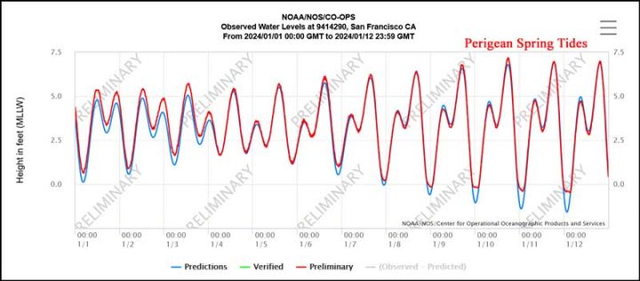
More properly, King Tides are perigean spring tides. They don’t just happen in the Spring season. “Often between 6-8 times a year, the new or full moon coincides closely in time with the perigee of the moon — the point when the moon is closest to the Earth. These occurrences are often called ‘perigean spring tides.’ High tides during perigean spring tides can be significantly higher than during other times of the year.”
How much higher?
That depends on the exactly location, the date and the year all taking into account the cycles of the Earth and the Moon.
Here is San Francisco, California, (the major city of “the Bay Area”):
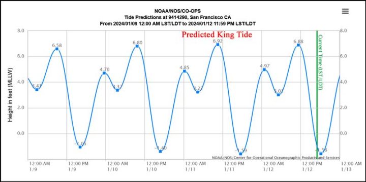
The first thing you will notice is that the tide charts have a “funny” shape – this is called a “Mixed Semidiurnal tide cycle. An area has a mixed semidiurnal tidal cycle if it experiences two high and two low tides of different size every lunar day.”
Oh, what’s the matter? You don’t see a huge dangerous looking King Tide? Correct – the King Tide happened, it was about 1 foot higher than the more normal Mean Higher-High Water (MHHW) for this tide station, which is 5.84 feet above Mean Lower-Low Water.
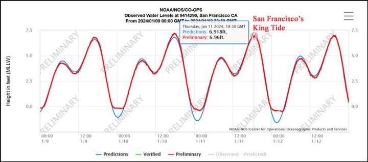
This graph will give you a better view:
You can see not only the higher highs but the lower lows as well, under the influence of the Moon. Here is last year’s January King Tide, at 7.68 feet:
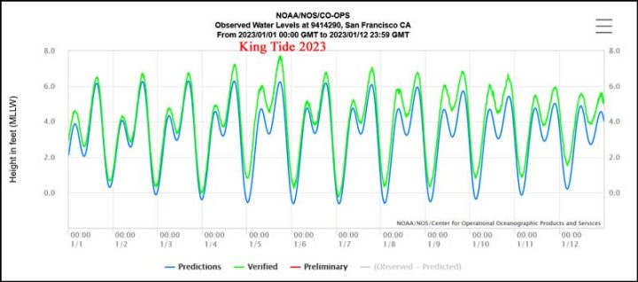
which was almost a foot higher than this year’s.
And Climate Change? Not related at all.
The only factor that affects King Tides is the mean sea level at the location in question. And for the coast of California, sea level rise isn’t much of a factor.
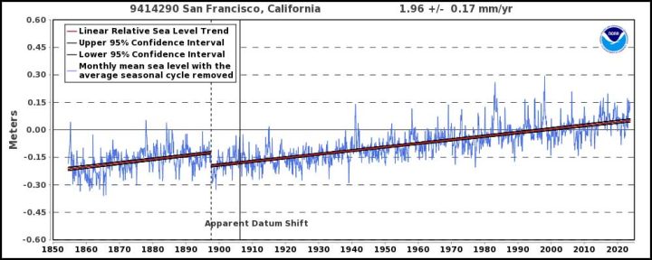
About four inches in 50 years, right in line with the expected 8-10 inches per century of global sea level rise as measured by tide gauges around the world.
The local mean sea level will control the height and range of the normal tides. As mean sea level in the Bay Area rises, and it will, slowly and inexorably, at about two millimeters a year, the King Tides will advance the same small amount each year.
# # # # #
Author’s Comment:
Journalists working in today’s media seem to be simply incapable of thinking for themselves or of actually doing any fact-checking or back-grounding when it comes to anything that touches on climate, weather, sea levels, storms, hurricanes and all that. They just parrot talking points from the climate crisis agenda.
Not to worry, King Tides are just perigean spring tides. Those locations adversely affected by King Tides are too close to local mean sea level and need to be raised or protected. And that’s all.
Thanks for reading.
# # # # #
It would seem to me, that anyone who wishes to build on ground that may be affected by perigean spring tides, should as a rule of thumb, build at least 1 foot above the highest recorded tide. It won’t protect you from storm surges, but that is an entirely different matter.
Gilbert ==> The sea is a force to be reckoned with. 1 foot will not do at all if you value your property. The best rule of thumb, enshrined in building codes in some areas, is no habitable spaces less than 8 (in some places 10) feet above historical highest high water.
But your heart is in the right place — they need to raise or protect their homes if they are already affected by King Tides.
Ok… I stand corrected… thank you
“High water” is not just due to tides … it must take into account storm related events. NOAA produces flood maps for the US that are based upon historical flood elevation data for every location. Flooding can result from rainfall events of varying intensities, durations and frequencies. But in coastal areas flooding is often more due to strong winds and low pressure systems associated with either cyclones or strong pressure fronts resulting in “storm surge”.
The worst case scenario for flooding is hurricane-induced storm surge on top of the king tide or even just a normal high tide event.
Here in Florida, due to historical hurricane events and measured storm surges, the state building code requires that occupiable first floor elevations be set above the 100-year event. In coastal areas that results in FFE at 12 or more feet above MSL. Additionally, in areas designated as “coastal construction zones”, additional restrictions apply to non-occupiable facilities like car ports, storage rooms and such.
As a result of Hurricane Ian in late September 2022, the difference in storm damage in coastal areas most impacted were rather amazing in contrast. In Fort Myers Beach nearly all the structures built before the current building codes were implemented in the 1990s (as a result of Hurricane Andrew damages) were utterly destroyed. But virtually all of the more recently built structures were preserved with little more than minor damage and cleanup needed.
Duane ==> Up here, most building codes use “highest recorded high water”. This is different HAT (Highest Astronomical Tide).
Thanks for the details on Florida’s codes.
One has to be careful not to use NOAA maps that use IPCC se level rise predictions for coastal locations.
The NOAA flood maps are based strictly on historic statistical analyses and togograpgical survey data, nothing to do with IPCC or harmonist climate forecasts.
Years ago I lived in Cape Town (mediterranean winter rainfall climate) for some years. I noticed how around the southern winter equinox (22 September) we often had both a high tide and bad storm. It was not climate change that was responsible but simply normal seasonal weather conditions together with the high tides. The storms together with the high tide pushed in huge waves.
Real time observation trumps climate models.
Michel ==> “Real time observation trumps climate models.” Every time!
And then you have to think about the waves.
And if they don’t get you, then the saltwater induced corrosion probably will.
I’d pick several km’s from the ocean, especially if surf present. Most steel cladding has limited or no warranty for locations within half a km of the ocean.
Eng_Ian ==> Born and raised in Los Angeles, California, We always bought cars from the desert,not the coast, for that reason.
In Vermont, you cannot do new build, except above the highest flood line.
The latest was during Hurricane Irene.
A friend watched a very wide Ottoquechee River go by his house, about 3 ft from the foundation of his 1845 house. One more ft, it would have wiped out his house. His wife got scared and ran up the hill.
The land can be used for agriculture
Many pre-existing building have been grandfathered, but likely pay through the nose for flood insurance
willpost ==> NY State has similar building codes now. An historic customs house on the Hudson River was being renovated for the umpteenth time, and this time they were allowed no habitable spaces and no furnaces, water heaters, etc on the ground level. The builder hung the hvac system from the first floor ceiling to get it above the required height, used ghe rest for storage.
Readers ==> I am “out of the office” for the next 18 hours, but will return to answer any questions you might have.
Good, and timely, article Kip. As you say “…todays media seem to be simply incapable of…fact checking…”, but I wonder, what percentage of todays media that would happen to fact check, and discover the climate change flavor of the day is false, would speak up or just simply ignore the data and change to another subject? The group-think is strong with the majority of todays media, and going against them often seems to result in retribution or even termination.
Ron ==> There are lots of journalists that have come out and said ‘We can’t write against the Climate Change agenda” unless they quit first.
We live on hood canal, had a King tide coupled with a low pressure zone last year. End result was our neighbors had roughly half their waterfront yards flooded. Their septic fields were above that, so no serious damage. We have a concrete bulkhead, so very little damage.
schoomzer ==> Thanks for the photo. If you could send me a full sized copy, with a fuller explanation, I could use it in a future essay. If you’d like, send it to my first name at i4.net.
March 10th 2024, Lunar perigee about 2 hours from New Moon, 10 days before the Vernal Equinox.
https://www.fourmilab.ch/earthview/pacalc.html
Ultric ==> Thanks for that link.
Ultric ==> And one can line that up with the tides and see when it will be higher and lower.
Scripps isn’t the only organization fanning the flames of global warming/sea level rise. Being an old surveyor, I still subscribe to ‘The Evergreen State Surveyor’, and their most recent issue catches NOAA in the act as well. In a discussion of their normal adjustment of tidal datums on the 19-year cycle, we find the expression “the average rate of sea level rise continues to increase” appearing not once, but twice, in the same words. Now I’m pretty convinced that the tidal datum adjustment will be meticulously performed, and the new National Tidal Datum Epoch (NTDE) will be wholly reliable as published in 2026, taking into account both the changes in local sea levels and the rises and falls of local earth’s crust as time passes. But don’t NOAA’s long-term plots of sea levels here and there show pretty much a fixed rate of increase, rather than ‘rate continues to increase’? May I guess that some editor got inspired to inject some consensus politics into this technical journal, rather than letting the scientists have all the fun with their near-fixed rate of rise?
That happens when you promote Kindergartens to Universities, even using famous names like Harvard, MIT, or UPenn.
sensitive,
Australia’s government research body CSIRO printed this graph on sea level acceleration in the 2022 state of the climate report with the Bureau of Meteorology. (I have made slight modifications for easier reading).
Seems like old stories die hard.
Geoff S

sheero01 ==> This is the corrected graph:
CISRO and NASA use the slow down in Sea level rise to create an acceleration. On the left, SLR is ~ 2mm/yr….slows down in the middle, and on the right goes back up to 2 mm/yr. They use the “curve” to “prove” acceleration.
Over the length of the records — linear.
insufficientlysensitive ==> Oh for heaven’s sake — don’t make them use their own physical measurements — it embarrasses them.
The datums will be calculated from very local information. So they will be MOL correct.
NOAA is required to go along with NASAs satellite fantasy sea level, and say these crazy things, like sea level is accelerating. . But it still shows the local tide gauge station records honestly — so far refusing to modify them in any way to match NASAs satellites.
As a surveyor, I’ve used their tidal benchmarks for decades with great confidence, and yes, they’re all local determinations. Totally fine. It’s just that I’ve seen several instances of NOAA long-term data plots of sea level at one location or another, and they look remarkably like straight lines without the mendacious hockey stick at the end.
insufficient ==> Yes, that is exactly correct. “they look remarkably like straight lines”. Sea level has been at a steady rate for at least 100 years — with very little variation from the linear trends.
For a more complete look at the topic, see my series on Sea Level: Rise and Fall
Almost everything that happens outdoors can be demagogued in service of the Climastrology Narrative.
There’s a Nobel or a Pulitzer out there for the clever pious Climastrologer who can link tsunamis and volcanic eruptions to anthropogenic CO2 emissions.
Somebody will probably link to stories doing both of those I have little doubt.
Rich ==> You gotta keep up, buddy. They have already linked Climate Change to Volcanic eruptions....there’s a study!
So where exactly are the websites claiming that “King Tides are caused by climate change “.
Not a single such web site is offered as evidence. There is a difference between saying that in the future averge high tide levels will be the same as current King tides and saying that King tides are caused by climate change.
You didn’t notice that the essay provided the link right where it made the claim?
I clicked on the link and it is simply a link to a search for “King Tides” on google. And at least when I looked at it it is all a link to factual pages about King Tides and none claim they are due to climate change.
So where exactly are the websites claiming that “King Tides are caused by climate change “.
You must be joking. Every time people get their feet wet these days they blame the ”changing climate”.
There are plenty of articles saying that King Tides show how Climate Change will affect normal Tides by 2050
https://www.epa.gov/cre/climate-change-coastal-communities
Then there are some that do make a connection
https://www.wwfpacific.org/?371276/WWF-calls-for-greater-climate-change-support-as-Pacific-communities-flood
Climate change is raising sea levels around the world, so it is easy to imagine how this would make flooding events from king tides more severe
https://utopia.org/guide/what-is-a-king-tide-the-connection-to-climate-change/
I saw one of those links mentioning that climate change would make King Tides higher. So that particular prediction about King Tides is related to climate change.
ALL I can say then is you didn’t look very hard, Mr Walton – a creature of habit, perhaps, which explains why you are the way you are about matters climate.
I don’t use Google but even my reluctant search found a “tree hugger [sic] article” from 2022 which has a section (No.4 – headed King Tides and Climate Change) about rising sea levels and the usual doom and gloom ‘we are all going to die’ despite all the pains taken to separate the phenomena from climate change elsewhere.
“I see what I wanna see;
I know what l wanna know;
I don’t need you;
to tell me what’s true;
if you don’t like it you can just blow, blow, blow”
… lzakk
King tides are being used to scare people about climate change with bogus claims, as usual.
This is what is being claimed. Then the reality is that in Spain, over the last 60 years, the sea level has increased by less than 10 cm. So we have to believe that in the next 25 years, it will increase by 30 cm. This is just lying and fearmongering.
Javier,
King Tides might very well be used to scare people but that is not what Kip is claiming he asked “ why are there so many sites claiming that King Tides are caused by climate change or sea level rise”
And I would like him to provide at least one website that claims that King Tides are caused by climate change. All the websites that he mentions use King Tides to show how sea level rise in the future will effect communities which is a very different thing.
Izaak ==> This is the last time I will do your homework for you: “WEATHER Experts say climate change is causing record high flooding during king tides…Sea level rise caused by climate change is causing record water highs during the seasonal king tides.”
1 out of 100s.
Kip,
that link states that climate change is making King Tides worse. That is a very different thing from what you stated i.e. “that King Tides are caused by climate change or sea level rise?” So again can you point to me a single website that says that King Tides are caused by climate change?
There is a lot of nonsense out there about all manner of things including climate change but you adding to it my claiming things that appear to be wrong is helping.
Izaak ==> It is the title that says it — most readers get stuck with whatever is expressed in the title and lede of an article — they almost never read the details below.
““WEATHER Experts say climate change is causing record high flooding during king tides“
Kip,
it seems that you are unable to read and understand headlines. The one in question does not imply that climate change is causing King Tides but only that it is making them worse. Which is exactly the same thing that you say when you say that “As mean sea level in the Bay Area rises, and it will, slowly and inexorably, at about two millimeters a year, the King Tides will advance the same small amount each year.”
Now climate change is causing the ocean to warm which is causing the water to expand which is responsible for some portion of the sea level rise you mention. So clearly climate change is making King Tides worse, just as subsistence is making them worse and land use changes are making them worse but none of that is causing King Tides.
Izzy…. are you deliberately ignorant of everything going on in the world of “climate change™” ???
For such a died-in-the-wool rabid climate zealot, you seem to have basically zero knowledge of what your “climate comrades” are yabbering about at any particular time.
“died-in-the-wool rabid climate zealot”
nice, I gotta start using that here in a state full of them- Wokeachusetts!
If you do, make sure you spell ‘dyed’ correctly or they’ll just laugh at you.
Here in Maine, the Midcoast got slammed by flooding twice in a week by multiple factors, including King Tides. 1st, 12+ inches of snow, followed a few days later by a very strong coastal storm with very strong S/SE winds (70 mph gusts) that bottled up the N to S flow of coastal rivers, ~3+ inches of rain, warm temps that melted that 12+ inches of snow, lunar perigee at new moon, earth perihelion…all added up to tremendous coastal flooding/damage. A 2nd near identical storm followed 4 days later today. The tides were going to be high anyway, but the storms added tremendous amounts of water/snow melt & the winds slowed the water’s drainage to the ocean.
It’s all CO2’s fault…///…
Unusually high tide yesterday afternoon on Cape Cod due to the recent storm (wicked winds from the SE +55mph steady). We live on a salt water kettle pond connected to Pleasant bay in Orleans Wokechusetts (Kescayogansetts pond). As I told my neighbors, “It’s weather NOT climate”. Our house is 17ft above mean high tide and not in a flood zone, so we did not have to worry. Mother Nature gave us a treat, as a small harbor seal (much smaller & cuter than the gray seals we commonly see around the Cape) took advantage of the tide to rest on the dock next door. We call the place “little Heaven”…
TRex ==> Thanks for sharing the photo of the seal. We have had a seal last couple of summers spending time 100 miles north of NY City in the Hudson River…performs tricks for the amusement of the boaters.
tardigrade ==> Maine has always been a spot for heavy weather. Wait for the next El Niño powered Nor-easter!
Are these the same as the (roughly) Spring and Neap tides we’ve known about for centuries? Spring Higher than average,Neap lower.
For UK readers there’s a documentary on Thames Flood of 1928.
https://tv24.co.uk/b/s7kx20-134t
Saturday January 20, 9:30pm
on Channel 5 HD
Tidal range is greatly affected by geographic areas. The tidal range in the Thames River estuary or “tideway” is up to 24 feet, storm effects notwithstanding. Here in south Florida, the tidal range is less than 4 ft.
The tidal range in the Mersey estuary in the UK can be up to 9 metres (over 29 feet) but Liverpool and Birkenhead still face one another across the river mouth as they have long done 🙂
Duane and Dave ==> There is a great map of tidal ranges at ARCGIS . Up to 13 meters!
ben => Yes, exactly the same, it is an astronomical phenomenon. They have just made up a new name for them (at least for the high ones, the Spring tides). Thanks for the link — readers in the UK should mark their calendars.
As can be seen in the last figure of the article, the sea level has been rising linearly in San Francisco since at least 1900, without any appreciable effect on the rate of rise from the strong increase in emissions since the 1950s, the increased warming since 1976, or the enhanced glacier melting since the 1980s. There is no scientific or rational basis for the belief that reducing our emissions will affect sea level rise if increasing them didn’t.
Which of course makes perfect sense given that the Earth is well into an interglacial period where , if nothing changes, will inevitably result in the melting of all glaciers world wide and thus reach peak sea levels.
The entire Florida peninsula, with a peak surface elevation of about 200 ft above MSL, has at numerous times in the geologic past been completely inundated … and at other times during glacial eras has been approximately twice as wide as it is today. All due to natural climate change.
An interesting result of Florida’s repeated cycle of inundation followed by sea level retreat is the record of archeological artifacts found to date. The oldest evidence of human occupation is dated to approx. 5,000 years ago, while in other parts of North America human artifacts have been found and dated to anywhere from 12,000 to 22,000 years ago. The theory is that pre-Colombian peoples in what is now Florida generally resided only along the coast because the inland swamps were not hospitable to humans. So it is postulated that all the artifacts older than 5,000 years are likely sitting on the sea floor within the relatively shallow coastal shelf, particularly along the Gulf of Mexico.
The interglacial periods last about 10,000 years but they can vary widely.
It has been about 11,700 years since the last glacial period so a new glacial period might be coming.
The Grand Solar Minimum and the Beaufort Gyre may be the triggers
Some people, with no understanding of either science or math, think if something is rising- that means it’s accelerating. That must mean—- OMG, it’s a climate emergency!
Joseph ==> The Sea Level Cabal has created “accelerating sea level rise” out of tacking two incommensurable data sets end to end — the tide gauge series and the satellite series.
“tacking two incommensurable data sets end to end”
like the hockey schtick
I stopped at the first occurrence of “could”.
Meanwhile, I COULD win the trillion dollar lottery. I COULD be the next human to go to the moon. I COULD have a glacier push my house over. I COULD develop tolerance of living in Wokeachusetts— but nah, that last one won’t happen.
Declension also is a factor in the height of HW.
If the sun is at 20 degrees S and the Moon is at 20 degrees N then a spring tide or a king tide will be smaller than one when both bodies are at 20 degrees N.
And of course declination.
Chronometric disfunction, aka old age.
So, King Canute in the 11th century, with no modern scientific education, was smarter and wiser than the highly credentialed morons at the Scripps Institute of Oceanography?
Sounds about right.
Wouldn’t be difficult.
Climate science is the new go to occupation for people too stupid to understand data and facts, or deceitful enough to realise its awell paid easy iving with some nice earning opportunitoes, as Clive James summarised so well in his last piece for the GWPF, Mass Death Dies Hard.
now they are allowed to make them up in computer models from Matlab they can programme with whatver belief du jour needs proving. Soon they will just ask ChatGPT or whateverit is for rproof of their curret theory and it will be proof by AI, that cannot be questioned., and also keen to avoid real work at the taxpayer;s expense.
Sorry about the typos, hate the lack of a correct/edit facility. Point is still obvious.
“King Tide” is one of our local TV station’s favorite fear stirring terms, often coupled with ” storm driven waves”(as opposed to the other sort of waves), blood moons, super moon, etc. I believe they’re aided and abetted by the NWS which has also become a major mouthpiece for the climate hype industry.
Don’t forget “Bomb Cyclones.”
Willy and scvblwxq ==> One of the greatest tools of the propagandist is the redefining of common words….
There was a young girl named Bea
Who thought she would go to the sea
She first parked her car
And then walked very far
She went wading up to her ankles.
If you are concerned because this doesn’t rhyme, just wait for the tide to come in.
doonman ==> This doesn’t turn into a “dirty” limerick, does it?
Only if you can think of a dirty word that rhymes with ‘sea’?
Wrong again? Surely an “ar” sound.
Sure. And we can teach kids about the impact of a barely noticeable 1.5 degree rise in average temperatures over a 170 years or so by dropping John Kerry into an active volcano
Andy ==> Hmmmm….what lesson would it teach? don’t make Pliny the Elder’s mistake?
How’s about Doozy TIdes? THey come every 18.6a at the eccentricity maximum of the lunar orbit. There are 9.3a harmonics as well. The last two coincided with the 1998 and 2016 El Ninos and I suspect the solid gravitational tide maximums at this time can and do increase submarine volcanic activity, along with other causes in what is a clearly multi-cyclical interference of the ENSO cycles.
Brian ==> Are you sure that’s a thing?
Why would I write what I had not already read the data on? That is for those who are not scientists, and/or don’t understand science.
Not sure what a “thing” is in science, I need a definite description of what you mean by that.
The LUnar eccentricity cycle I mention is a well known natural cycle you can check for yourself. Always best to verify.
It seems I was a year out as regards the last Lunar eccentricity peak effect, which was 2015’ish. I expect you can find the same peak in tides you are familar with – Mont St, MIchel had a periodic “record” then. But that “record” would be stupid jounalists with no ability to, or interest in, going back as far as 18.6 years to check their claims. Why spoil a good story with facts?
.Obviously the eccentricity cycle has to coincide with a peak Spring Tide for peak tidal effect, when the complementary alignment of the Sun, Moon and Earth create maximum gravitational attraction of the oceans on the Earth’s surface, and also of the visco elastic Earth itself which has matching solid tides of tens of centimetres. All well known science.
I have no idea what a King tide is, or a Queen tide, come to that. It’s not a scientific word. Science has descriptions for tides without it. The point here is that these are tides, not to do with rising sea levels. Some up to 40 feet max to min, where the continental shelves and natural funnel shaped estuaries combine to compress waves from the deep ocean into increasingly shallower and narrower cross sectional areas. In the UK that is the Severn Bore, There is another in France at the Rance Estuary. Does the St Lawrence have a high tidal range. Tides in the opne ocean are tiny, I see 2.5-3 metres on Pacific atols, which are not that much above sea level at high tide, so much more would be a problem….but the atols rise above any change in tidal levels IF given time to accrue debris from the reefs. etc.
https://www.coastalwiki.org/wiki/Long-period_lunar_tides
Very nice, lots of good information.
“But as climate change pushes sea levels higher, the flooding apparent during king tides could soon become permanent. Current projections estimate that the Bay Area could rise by approximately two feet by 2050, which would put our permanent shoreline at the water level seen during king tides.”
How can they get away with saying things like this?
Bob ==> 1) Ignorant journalists. 2) Failure to fact-check anything 3) Editorial Narratives — required viewpoints that must be expressed in every article on a topic
For sea level to rise by TWO FEET in the next 27 years, mean sea level there would have to rise 22 mm per year for that entire period. (2 feet =~ 609 mm / 27 = 22.5)
The current long-term (over 100 years) rate of SLR in San Francisco is under 2 mm/yr.
Sea level would have to start rising ten times faster, starting immediately and continuing for 27 years to reach that level.
Ignorant, innumerate, parrot-minds.
Also see the Canvey Island disaster in the Thames Estuary (1953?) which was a “perfect storm” of all the tide enhancing effects, a low pressure/ high wind onshore North Sea storm (its a classic estuary and a shallow sea) plus a spring tide.
“F***** you are”, as Yoda might say.
This was bad because it was just post war and people were in temporary housing , many had been evacuated here from the bombing in East London carried out as part of the Luftwaffe urban re-development scheme for the London docks.
After the predictable disaster government replaced the inadequate earth bank levees with serious concrete. Just like governments everywhere, wait for the accident to happen and then defend against it. Useless people run all our countries, wasting money on imaginary problems that enrich their cronies that we can’t measure them on, instead of spending it where there are real problems affecting the mass of poorer people.
Also See New Orleans.
BTW I was told recently that is an accident waiting to happen because the Mississippi has not been allowed to change course to a new estuary as such rivers naturally do, and the Rhine has so obviously done, moving from the Zuider See to Antwerp over the millenia, as the silt builds at the spreading estuary and creates a back up. Again, these tides are well known, cyclical, and not climate change, as pointed out. That’s bullshit based on simple, provable lies – made up by liars and believed by fools.
Brian ==> The situation with the Mississippi Delta is very complex, complicated and involves chaotic functions. I have written about it before.