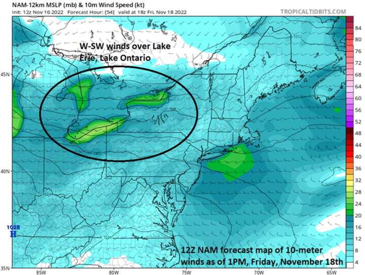
The “perfect” scenario for places like Buffalo and Watertown of western New York State to get pummeled by snow in a Great Lakes snow event is for an extended period of time with low-level W-SW winds – and this is definitely on the table for these locations from later Thursday into the upcoming weekend. Map courtesy NOAA, tropicaltidbits.com
Paul Dorian
Overview
Temperatures across the nation on Wednesday morning averaged out to an impressive reading of nearly 12 degrees (F) below-normal for mid-November and no state in the Lower 48 escaped the colder-than-normal chill. The first widespread snow event of the season took place late Tuesday across the interior, higher elevation locations of the Mid-Atlantic/Northeast US with half of foot of snow recorded in many spots. The next few days will feature a “Great Lakes snow-making machine” that will be turned on in full force and the result may be several feet of snow in some downstream locations such as Buffalo and Watertown in western New York State. The nationwide cold wave will continue right through the upcoming weekend.
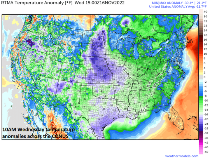
The nationwide temperature anomaly on Wednesday morning was an impressive nearly 12 degrees (F) below the average for November 16th. The unusually widespread early season cold wave will continue across much of the nation right through the upcoming weekend. Map courtesy NOAA, weathermodels.com (Dr. Ryan Maue, Twitter)
Coast-to-coast cold continues
The first couple of weeks of November saw temperatures average well above normal in much of the eastern half of the nation, but the overall weather pattern has certainly changed in a significant way. Virtually all the states in the Lower 48 experienced colder-than-normal chill on Wednesday morning with the 10 AM nationwide temperature anomaly registering at nearly 12 degrees (F) below the normal for the date. This early season chill down will continue through the weekend in most of the country as reinforcing cold air masses drop into the US from Canada. In fact, the next cold air outbreak will likely result in numerous low temperature records later in the week; especially, across portions of the central US where temperatures could drop to as much as thirty degrees below normal for mid-November.
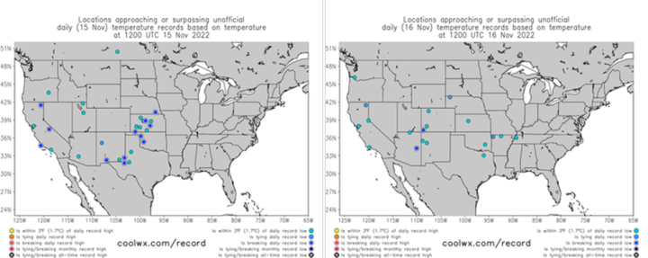
There was a smattering of near or record low temperatures set on Tuesday morning (left map) and Wednesday morning (right map). More numerous low temperature records are likely to be set later in the week with the influx of an even colder air mass; especially, across the central states where temperatures could drop to nearly thirty degrees below-normal. Maps courtesy coolwx.com, NOAA
First snow event on Tuesday in the interior Mid-Atlantic/Northeast US
Low pressure developed late Tuesday near the Mid-Atlantic coastline and then intensified as it pushed to the northeast in the overnight hours. A cold soaking rain took place along the immediate I-95 corridor (although some flakes and ice pellets mixed in at times), but it turned out to be the first widespread snow event for many interior, higher elevation locations of the Mid-Atlantic/Northeast US with half of foot measured in many spots.
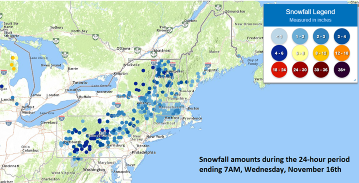
The interior, higher elevation sections of the Mid-Atlantic/Northeast US experienced their first widespread snow event of the season late Tuesday with many spots receiving as much as half a foot of snow. Map courtesy NOAA
Intense Great Lakes snow event on the way
Beginning late Thursday and continuing through much of the weekend, the atmospheric setup will be just right in some downstream locations of the Great Lakes for an intense and potentially crippling snow event. Very cold air for this time of year will persistently pour over the still relatively warm waters of the Great Lakes and this action will destabilize the atmosphere in what is likely to become a long duration event into the weekend.

The potential exists for extreme snowfall amounts in coming days of up to several feet in places like Buffalo and Watertown in western New York State. Map courtesy NOAA/Buffalo NWS
It is always a difficult forecast to pin down the all-important exact wind flow in this kind of upcoming localized (“mesoscale”) weather event, but it appears there will be an extended period of W-SW winds blowing across Lake Erie and Lake Ontario. This is the perfect wind trajectory for places like Buffalo and Watertown to get pummeled with heavy snow bands as this wind direction allows the air to flow over the lake of interest (Erie or Ontario) for the longest time possible given the geographical orientation of each lake. Given this expected wind flow scenario, copious amounts of moisture will push into Buffalo (from Lake Erie) and Watertown (from Lake Ontario) in the form of intense snow banding. This kind of event has the potential of dumping several feet of snow in localized areas such as Buffalo and Watertown with incredible hourly snow rates possible…a potential paralyzing early season snow event.
Meteorologist Paul Dorian
Arcfield
arcfieldweather.com
Follow us on Facebook, Twitter, YouTube
I just stocked up the ring type log rack. When full as it is now, it will hold enough for 3 days continuous burning at maximum level.
Thunder snow going in Buffalo tonight! 48 to 60″ coming.
https://video.twimg.com/ext_tw_video/1593401694741823490/pu/vid/480×270/5YQaMTzZ5SPfr5aC.mp4?tag=12
I heard only 3’ prediction
Moved football game
uh hu!
Buffalo declares a state of emergency as it braces for brunt of lake-effect snowstorm (msn.com)
The front pulls all the moisture from Lake Erie to Buffalo.

Saw this coming 2 weeks ago at NOAA CPC forecast webpage.
Global warming is cooling, if you didn’t know.
“Extremely heavy lake-effect snow continues to fall in Buffalo’s southern suburbs Friday morning, with whiteout conditions and snowfall rates exceeding 3 inches per hour in spots such as West Seneca, East Aurora and Dunkirk, New York. This snow band will remain over the same general region, though could wobble northward into downtown Buffalo later in the day, AccuWeather forecasters caution. The National Weather Service heavily cautioned against travel within this band of snow, stating that travel would be impossible as heavy snow fell.”
I’ve seen Ice rRoad Truckers
that picture still looks beautiful. Assuming you’re out there dressed properly or inside looking out?
Not trudging through it having abandoned your tank and looking for hospitality /shelter with the local villagers whom you’ve been shooting at for months…
Could it get any colder in the US over the weekend? Maybe.
http://tropic.ssec.wisc.edu/real-time/mtpw2/product.php?color_type=tpw_nrl_colors&prod=namer×pan=24hrs&anim=html5
Was below zero this morning when I woke up. A few decades ago, the smart people told me that I’d still be growing tomatoes until Christmas.
Wow! Orchard Park NY is less than 24 hours into this, and they are closing in on six feet, at the rate of 7 inches an hour of snowfall now. I lived there for five years in the early 80s, just to the south, at the foot oh Chestnut Ridge Park.
The snow is usually low water content and tends to settle during wind storms. I put roof studs on 8 inch centers rather than 24 inch, so such snows would not crush my house. The winter lightning was something else; scared the living shit out of me more than once. One blew up my chimney and fire-place, destroying my washer, dryer,TV and my furnace before making a small glass-lined hole in my basement concrete floor. As it was 10F / -12C at the time, the furnace had to be attended to right away, thick snow or not. Another time, winter lightning blew my big willow tree to bits.
About measuring such low density snows, I gave up on the huge amounts every few hours. I just measured the change in total snow pack depth every 24 hours. Still, tonight’s storm is really breath-taking. There will be plenty of work trying to get out from under neath that!
Driven by that stadium many a time. Have a shipper almost within sight of it.
That is one thing I really like about my house. The original part was built in 1943 and the rafters are real 2″ x 10″. High quality spruce lumber from back when a 2 x 4 actually measured 2″ x 4″.
One day you’re basking in climate change, the next you’re freezing your nuts off . .