Guest “I’m embarrassed to admit that Charleston is where my ancestors first settled in the US” by David Middleton
Hat tip to Willie Soon…
Suing over climate change: Taking fossil fuel companies to court
APRIL 17, 2022 / 9:50 AM / CBS NEWS
If climate change were a disaster film, it would likely be accused of being too over-the-top: wildfires reducing entire towns to ashes, hurricanes swamping cities, droughts draining lakes and withering fields, and raging oceans redrawing the very maps of our coasts. And now, many cities and states are asking, who’s going to pay for all of this?
“This is real; we’re on the front line of climate change right here in Charleston,” said John Tecklenburg, the mayor of Charleston, South Carolina. The city’s been battered by an endless parade of floods due to sea level rise. Some desperate homeowners have resorted to raising their homes by several feet.
“In the next 50 years we’ll see another two to three feet of sea level rise,” Tecklenburg said. “The water is our greatest asset; it has also become our biggest challenge.”
[…]
CBS News
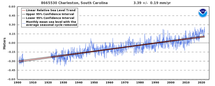
interval of +/- 0.19 mm/yr based on monthly mean sea level data from
1901 to 2021 which is equivalent to a change of 1.11 feet in 100 years.
NOAA
- 3.39 mm/yr * 50 yr = 169.5 mm
- 169.5 mm / 25.4 mm/inch = 6.67 inches ~ 0.5 feet
“What about sea level rise acceleration?”
What about it?
Variation of 50-Year Relative Sea Level Trends
8665530 Charleston, South Carolina
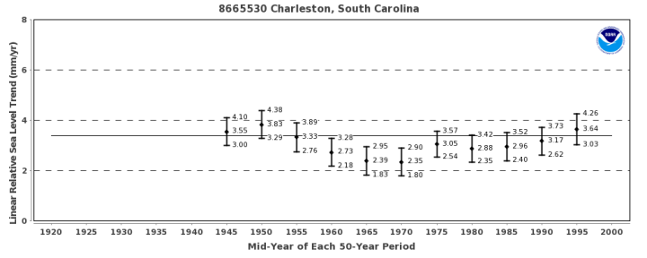
Linear relative sea level trends were calculated in overlapping 50-year increments for stations with sufficient historical data. The variation of each 50-year trend, with 95% confidence interval, is plotted against the mid-year of each 50-year period. The solid horizontal line represents the linear relative sea level trend using the entire period of record.
NOAA
Although the trend may vary with the end year, there is no statistically significant difference between the calculated trends if their 95% confidence intervals overlap. Therefore, the most recent calculated trend is not necessarily more accurate than the previous trends; it is merely a little more precise. If several recent years have anomalously high or low water levels, the values may actually move slightly away from the true long-term linear trend.
NOAA
“But, but, I see a trend there!”
Even though “there is no statistically significant difference between the calculated trends if their 95% confidence intervals overlap,” let’s just assume that apparent trend is real.

This would lead to a rate of sea level rise of 4.78 mm/yr in 2071. Just to make the math easier, if sea level rose at a rate of 4.78 mm/yr over the next 50 years, it would result in 9.4 inches of additional sea level rise… ~ 0.75 feet.
So, where in the hell is the money-grubbing Democrat mayor of Charleston getting two to three feet of additional sea level rise over the next 50 years? Possibly from the same folks, whose data indicate 0.5 to 0.75 feet of sea level rise over the next 50 years.

The figure shows the station’s annual mean relative sea level with its six regionalized sea level rise scenarios plotted relative to a 1991-2009 baseline period (i.e., year 2000 is the ‘zero’ for the figure) as described in the report on Global and Regional Sea Level Rise Scenarios for the United States.
NOAA
The “high” scenario has sea level rising by 750 mm (0.75 m) from 2080 to 2100, an average rate of 36 mm/yr. This is physically impossible. The average rate of sea level rise during the Holocene Transgression was only about 11 mm/yr.
The “intermediate” scenario features 400 mm of sea level rise from 2080 to 2100, an average rate of nearly 20 mm/yr over that 21 year period. Again, short of Doctor Evil melting the Greenland Ice Sheet with a space “laser,” this is physically impossible.
As is often the case in alarmist climate models, the “low” scenario represents the maximum sea level rise supported by actual observations.


Context: Tidal Ranges
Sea level rises (and falls) by 6 feet over a typical Charleston day…

Context: Subsidence
Scientists Working to Understand Sinking Land in Charleston, South Carolina
By Jan Wesner Childs September 23, 2020[…]
Data from a NOAA gauge in Charleston shows that about 5 of the 12 inches of sea-level rise at the site over the past 100 years can be attributed to subsidence. It’s not clear why the land is sinking.
One theory: it has to do with soil compression caused by large buildings, highways and other increased development.
“We’ve had buildings on the peninsula. Now we’re getting much bigger buildings on the peninsula,” Norm Levine, director of the Lowcountry Hazards Center at the College of Charleston, told the Post and Courier. “If we get out there now and kind of measure things, we can start understanding the susceptibility.”
[…]
The Weather Channel
The total sea level rise at Charleston over the past 100 years is just over 1 foot.
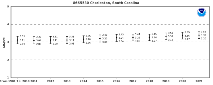
The relative sea level trend is 3.39 millimeters/year with a 95% confidence interval of +/- 0.19 mm/yr based on monthly mean sea level data from1901 to 2021 which is equivalent to a change of 1.11 feet in 100 years.
NOAA
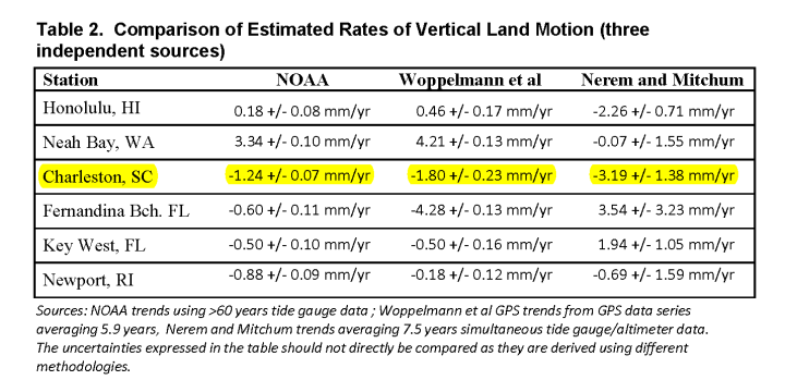
If 5 to 12 inches Charleston’s sea level rise is due to subsidence and there has only 13 inches of sea level rise, the money-grubbing Democrat mayor has a zoning problem, not a climate change problem. I wonder if Charleston advised purchasers of their bonds about this local problem?
I previously wrote about this junk lawsuit in this September 2020 post:
Charleston SC Junk Climate Lawsuit
Some highlights from that post:
South Carolina Flood Frequency Q&A
In 2015, Dr. Robert Holmes, USGS National Flood Hazard Coordinator, took time to discuss some issues related to the flooding in South Carolina following the Appalachian Floods and Hurricane Joaquin.
[…]
Is this flood due to climate change?
USGS research has shown no linkage between flooding (either increases or decreases) and the increase in greenhouse gases. Essentially, from USGS long-term streamgage data for sites across the country with no regulation or other changes to the watershed that could influence the streamflow, the data shows no systematic increases in flooding through time.
A much bigger impact on flooding, though, is land use change. Without proper mitigation, urbanization of watersheds increases flooding. Moreover, encroachment into the floodplain by homes and businesses leads to greater economic losses and potential loss of life, with more encroachment leading to greater losses.
USGS
JUNE 24, 2014
The History Behind Flooding in Charleston, South CarolinaFor many the idea of sea level rise and its associated impacts are thought of as future events. But, here in Charleston it’s already a part of life. Coastal flooding is a major issue that the city faces. All it takes is just the right tide, or even worse, an extreme high tide paired with a torrential downpour during rush hour, and Charleston’s streets become fingers of the Atlantic Ocean that no car can ford. It’s not hard to fathom that these flooded streets will one day become creeks and marshes. And in many cases that is what they once were.
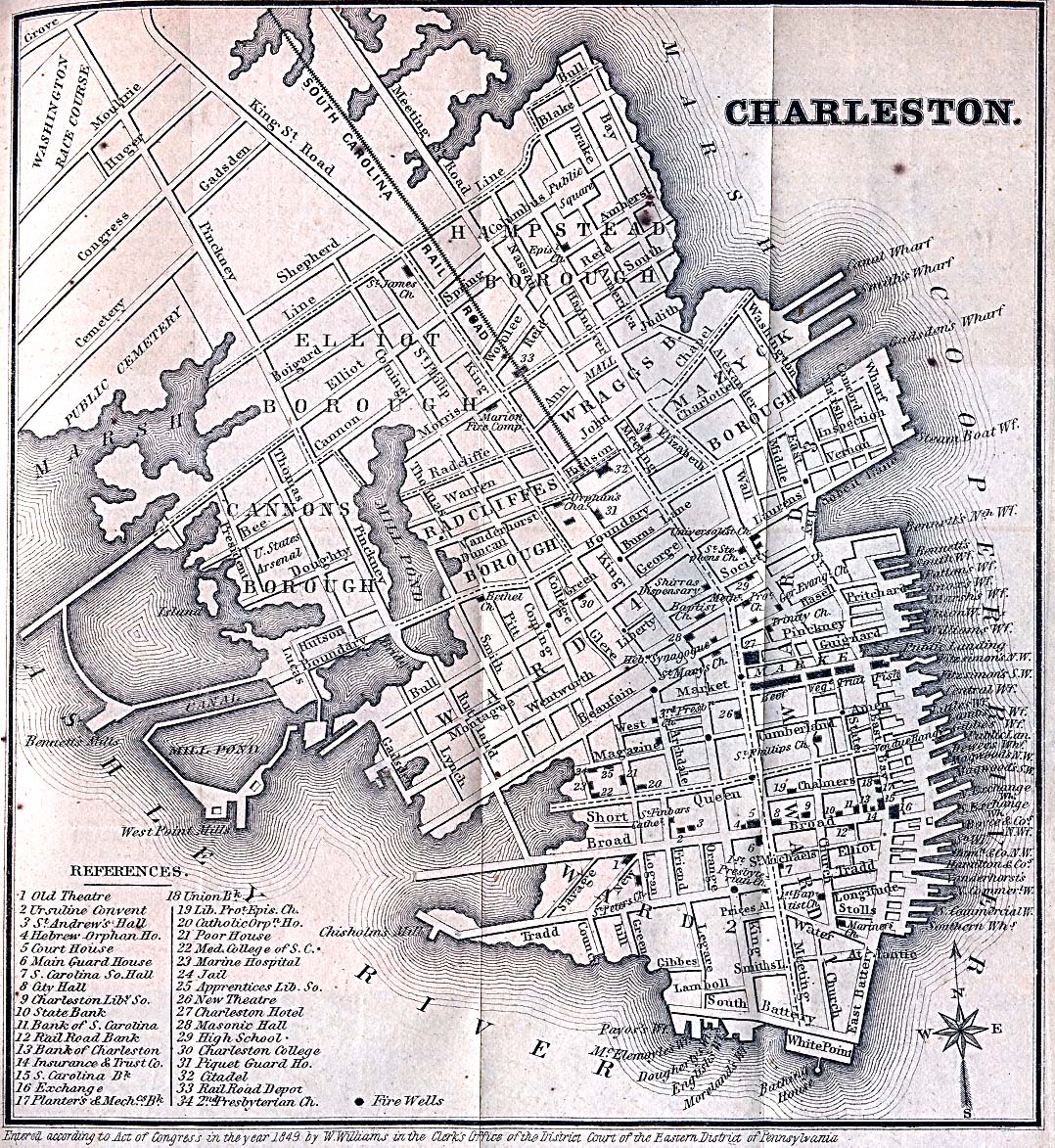
As far back as the 18th century, Charlestonians have made a practice of expanding the city’s footprint by filling creeks and marshes. Alfred O. Halsey’s Historic Charleston on a Map provides an amazing illustration of the change to the peninsula’s landscape (Preservation Society of Charleston [PSOC]). The map shows that many areas that frequently flood are atop man made land.
The aptly named Water Street in the South of Broad neighborhood was originally Vanderhorst Creek, until it was filled in 1792. Many are familiar with the images of kayakers paddling through the City Market after wayward bands from Hurricane Isaac flooded the city. This could have been a common sight if what was once Governor’s Creek wasn’t filled in to create Market Street in first decade of the 19th century. Both the Charleston Village and Cannonborough neighborhoods were filled in during the mid 1800s and both are notorious for their flood problems. The city has continued to alter the coastline as late as the 1960s. During this time, Lockwood Boulevard was constructed which resulted in cutting off the Charleston Municipal Yacht Basin from the Ashley River and converted it into a placid pond (Thompson 2013).
[…]
Geozone (NOAA Office for Coastal Management)
I put together a comparison of Halsey’s 1949 historical map (Preservation Society of Charleston) and an 1869 Charleston street map (University of Texas):

Charleston floods because they built much of the city in the Atlantic Ocean. And… let’s not forget subsidence.
As Mayor, he’d be far better off suing the city council for failure to plan for subsidence than any other mythical causes.
The ‘mythical causes’ get you some ‘Federal Grant’ money though.
Here in England nobody is more than 60 miles from the Sea. (think about that one for a moment if you are a US state).
The Eastern coast here is being eroded and the West coast is being built up. Both work the ‘system’ in that ‘global warming’ is the cause of all their problems.
Local and national ‘journalists’ are just there to get more ‘Federal’ money to deal with a problem that has been going on for thousands of years by pretending that it only started back in 1990.
The first humans inhabiting Britain likely walked across on the land bridge that connected Britain with France 100,000 years ago, until sea level rise eroded that away.
But if they sued the fossil fuel companies for that, likely the jury would find no damages and include a message of their profound thanks with the verdict.
No, as in many lawsuits, the issue is who has the most money that can be stolen. Real liability is often a very distant consideration.
All these law suits are ridiculous as, even if the harm predicted was real, they are aimed at the wrong parties. It is not the fossil fuel industries that burn the oil & gas and create CO2, it’s the public and businesses. Charleston should be suing itself, its citizens and the utilities that provide heat and power. They can hope for a giant judgement against themselves which they can then use to increase their budget.
A realy common source of land subsidence is ground water overpumping, which would be the responsibility of the local government.
Even the rapidly increasing population central Texas coast seems to have this problem.
Paine, J. G., 1993. Subsidence of the Texas coast: Inferences from historical and late Pleistocene sea levels: Tectonophysics. 222:445–458.
I’m not absolutely sure, but, I think the Charleston area gets its water from surface sources, the Edisto River and the Goose Creek Reservoir. I don’t think we get any of our major municipal supplied water from wells. Outside those municipalities, there a are a lot of shallow private wells. But, nothing that would effect subsidence near the water level station in our harbor in any way.
Our Mayor does these meet and greet things during the campaigns. Met him at one in our neighborhood. These idiotic flooding projects were starting to get some traction so I printed out the same NOAA sea level trend plot used in the story above and showed it to him. Asked how that showed any acceleration in rise. He said it didn’t and asked to keep the print out which I gladly gave him (was only a sheet of paper). Clearly, that sheet of paper went straight in the round file.
Charleston SC is built on coastal soft soil, which is incredibly prone to compression from heavy buildings without adding in any other factors such as overpumping. They need to consolidate the ground before doing anything else.
overpumping is such distasteful word. I’ would bet that virtually any ground water extraction would cause some subsidence
So basically, people with oceanfront property want the rest of us to pay for their deferred maintenance. No, thank you.
The secret is to purchase this property with student loans, aka double dipping.
Silly. Did anyone ask you? Why would they bother to ask first?
A perfect example of what the AGW scam really is: Forcing other people to pay for stuff that they are either unwilling or unable to get their own taxpayers to pay for.
A quick 5 minute look shows that Charleston is still approving LOMA’s … meaning that they are certifying that some specific properties that are in the FEMA mapped flood plain are ‘safe from flooding’.
They, as a floodplain management agency, are utilizing the non-exaggerated scenario to certify ‘reasonably safe from flooding’.
Prior to his political career, Mr. Tecklenburg was in commercial real estate.
There’s more money in politics. Just ask Brandon and son enterprises.
Money, not flood, is the real issue.
The only “local problem” for Charleston is their mayor, John Tecklenburg, who refuses to follow the science . . .assuming he can recognize science, as they say in the South, even when it hits him right between the eyes.
Excellent push-back, Mr. Middleton! Thank you.
Standby for a generation of indoctirinated school leavers who will swallow this nonsense hook, line and sinker.
GCSE in CLIMATE SCIENCE will be available from 2025 – focusing on how students can protect the planet
https://www.dailymail.co.uk/sciencetech/article-10727833/GCSE-CLIMATE-SCIENCE-available-2025.html#comments
The General Certificate of Secondary Education (GCSE) is an academic qualification in a particular subject, taken in England, Wales, and Northern Ireland. State schools in Scotland take Scottish Standard Grades, usually when students are aged between 14 and 16. They are considered to be equivalent to GCSEs in terms of difficulty and content.
“GCSE in CLIMATE SCIENCE . . . focusing on how students can protect the planet.”
Ummmm . . . shouldn’t a prerequisite for taking this class be “GCSE in the Vogon Constructor Fleet, focusing on introductory limitations of protecting the planet”?
I’d love to see the section on dealing with asteroid impacts. “Protect the planet” indeed!
Such studies will not deal with real environmental problems. Real environmental problems are so 20th century.
Take all the CO2 that we’ve removed from the atmosphere and use it to make a dry-ice shield in the atmosphere to protect the planet from the asteroids!
Child’s play.
Not only did that “CBS Sunday Morning” fail to undertake basic due diligence on the science part of their little report, they also didn’t fact-check any part of the “evidence” they dutifully regurgitated about the fossil fuel industry engaging in ‘disinformation campaigns.’ The “Chicken Little newspaper ad” they featured as their ‘evidence’ was never published anywhere, and the PR campaign they claimed had a goal to “reposition global warming as theory (not fact)” never operated under any such directive.
It would be interesting to learn if these kinds of frivolous lawsuits are being underwritten by an outside party (some environmental group). Would a countersuit be a way to discovery who the outside party is? could they then be sued?
I have already suggested these are possibly underwritten by dubious figures, based on the common denominator seen in 25 years+ of environs-activist character assassination accusations, and in the majority of the current AGW lawsuits, the Friends of the Court briefs in support of those lawsuits, and in unquestioned media reports just like this one at CBS Sunday Morning and last year’s very similar BBC report. Follow the green money in these cases.
IF you were able to fully follow that money trail, you would find much of it coming from Russia and the UAE, who are working to limit competition from the US, and consequent increased profits from the sale of their own products. It passes thru a number of shell companies, who then “donate” it to US NGOs, who pass it on to Sierra Club and the other Save the Planet (sic) conglomerates.
Great post and context Dave, thanks.
Easy fix, all “fossil fuel” companies stop doing business with Charleston. No electricity, no gas, no diesel or gasoline, no plastics or rubber or pharmaceuticals. Problem solved, people of Charleston can toddle on their way.
I wish they would. None of them have the courage to do it.
Norfolk, VA is very similar. Much of,the commercial area is built on landfill from the Elizabeth River. Flooding, particularly during Nor’easters when the water gets back up I’m the Chesapeake Bay, has been a common occurrence for at least 70 years.
That place is now off my vacation and visit list.
Stay at Patriot’s Point across the harbor. Not part of the city but a gorgeous view of it.
Will someone please give a link to what any of this has got to do with Carbon Dioxide.
That CO2 is pretty tricky. There’s no limit to what mischief it’ll get into,
“What about sea level rise acceleration?”
_________________________________________
And I didn’t see an answer in mm/year²
This web page:
Mean Sea Level at Charleston, SC, USA
says:
acceleration = 0.01094 ±0.01224 mm/yr²
Which is nearly nothing, and agrees with nearly
all of the long term PSMSL tide gauges that
have around 100 years of data.
Is subsidence rate explicitly part of that figure (not to take anything away from the ridiculousness of 5 decimal places)?
And I suspect that very tiny acceleration, which probably comes from the strong El Nino over 2015-2017 will become even tinier over the next years, as cooling sets in.
What happens when you calculate that acceleration, but end the calculation in 2014?
About 0.011 +/- 0.012. Government accuracy and precision you can rely on.
What happens to the tiny “acceleration” term if you stop the calculation in 2014, before the major El Nino event.?
Whatever the acceleration is, it doesn’t mean much: https://wattsupwiththat.com/2017/07/25/whos-afraid-of-sea-level-acceleration/
Reminds me of these two images from the effort by New York City to adapt to climate change.
The typical elevation of the existing esplanade is 8′, the current 100-year flood level is 11′, and an elevation of 13.5′ is required to obtain FEMA accreditation and funding for a project today.
So the Climate Conscious Committee all put their heads together and came up with a new esplanade of 12′ to 17′ and patted themselves on the back.
What I don’t understand is why they needed the Klimate Kooks to deliberate on a plan for the future that then fails to meet today’s existing FEMA standards?
Failure via virtue signaling.
So the mayor is outright lying and trying to cheat the rest of us. David Middleton proves this, as far as I’m concerned. The mayor needs to be held to account. More importantly his lies need to be reported all across the country. Lying and cheating are not acceptable and liars and cheats need to be exposed far and wide. He disgusts me.
He is pretty far down the list of people who have tried to scam funds to deal with their problems and fantasies.
That may be true but these scoundrels need to be held to account. I could care less who we start with but we need to get started. He looks like low hanging fruit to me, he should be taken down.
“Lying and cheating are not acceptable”
That no longer appears to be the case, from what I’ve seen last few years.
This reminds me of those commercials that usually begin, “If you or a loved …. call the Law Firm of …”.
Generally they want sue somebody on your behalf for damages (and they get a BIG cut of the settlement).
The damages might be real and present but their may not be an obvious connection to whoever manufactures what is claimed to be “the cause” of the damages. (Except in California.)
When did the Mayor of Charleston become psychic? Did he run for office based on his unique ability, or did it develop after his election?
It is indeed a special case of human ability when one can tell the future, in this case 50 years.
Uniquely, over the last decade, the southeastern U.S. coast, from Florida to North Carolina, has seen noticeable regional sea-level acceleration, where the Gulf Stream (part of the AMOC) skirts the coast. (It hasn’t appreciably affected New York, where the Gulf Stream is farther offshore) The cause is apparently a (presumably transient) acceleration of the AMOC.
See how the Gulf Stream follows the coastline, from Florida to North Carolina:
So it should not surprise anyone that that section of coastline is strongly affected by periodic variations in the Gulf Stream:
The correlation with the AMOC / Gulf Stream is obvious:
(Those graphs are part of a figure from Jackson et al 2022, which cites Desbruyères et al 2019 as the source.)
The U.S. East Coast is known for such fluctuations. Zervas, C. (2009), NOAA Technical Report NOS CO-OPS 053, Sea Level Variations of the United States, 1854 – 2006, says:
In most other places there’s little or no sign of sea-level rise acceleration. For instance, here’s Honolulu, which is arguably the world’s best sea-level measurement record:
https://sealevel.info/MSL_graph.php?id=Honolulu (interactive version)
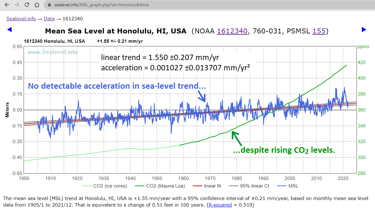
(click image to enlarge it, or see NOAA’s version, here)
You might wonder why I think so highly of the Honolulu sea-level measurement record? There are quite a few reasons:
● Unlike the U.S. east coast, Hawaii is not affected by variations in the AMOC.
● Honolulu has 117 years of continuous, top-quality measurements, from the same location, with no gaps.
● Honolulu’s location near the middle of the Pacific is nearly ideal.
The Pacific Ocean “sloshes east” during El Niños, and “sloshes west” during La Niñas, but Hawaii is near the “teeter-totter pivot point,” so, unlike the other long Pacific measurement records, Honolulu is scarcely affected by it. In contrast, look how strongly sea-level is correlated with ENSO at Kwajalein (in the western Pacific) and San Diego (in the eastern Pacific):
● Oahu experiences only small tides, and almost no vertical land motion (though it does move horizontally, about 3″ to the northwest, each year). Oahu is an old, tectonically stable island (several million years old, which is about 4× the age of the Big Island), and the volcanoes on Oahu are believed to have been inactive for well over a million years. So Honolulu’s sea-level trend is typical (about the same as the global average, i.e., about +1½ mm/year = 6 inches/century), and it is not appreciably distorted by vertical land motion.
● Unlike the north Atlantic and Baltic, Hawaii is not appreciably affected by Greenland’s slowly changing gravity field.
There are other sites with measurements going back even further than Honolulu’s, but all of them have either gaps in the records, or less-than-ideal locations. For instance, the Dutch have done a superb job of measuring sea-level for a very long time (for obvious reasons), but The Netherlands is close enough to Greenland that if Greenland’s ice melt were to accelerate (which is the potential source which is most plausible to cause sea-level rise acceleration) the Dutch would see a reduced effect. So, even though the Dutch measurement records are very, very good, they aren’t the best records to use for detecting possible acceleration from Greenland meltwater.
Still, I love this photo of a Dutch dike, next to a farmhouse, and a Dutch sea-level measurement record, because it so nicely puts the sea-level issue into perspective:
● The highly linear trend measured by Honolulu’s tide gauge is typical of most coastal measurement records, which have seen little or no acceleration for at least nine decades. The amount of measured acceleration reported in long tide-gauge measurement records has varied from negligibly positive to negligibly negative. This table from Houston (2021) summarizes the findings of ten of the best such studies:
I drew a pink box around the greatest acceleration reported by any of those studies: a mere 0.0128 ±0.0064 mm/year². A sea-level acceleration of 0.0128 mm/year² continued for 100 years would add a negligible 64 mm (2.5 inches) to sea-level — obviously not worrisome.
By the way, here’s a nifty color-coded visualization of the Gulf Stream over the course of a year:
I still say the oil companies should cease all shipments to municipalities and states that sue them over climate change.
If you are an independent trucker with a gasoline transporter, you could make a killing buying at the distribution site and “smuggling” it into stations willing to pay anything for product. The oil companies would probably even give it a wink and nudge while denying they know anything about it.
Perhaps my reading skills are slipping but I missed who is being sued.
Near the top of the post, in the quoted passage from the subject article:
Incredible to me that cities that are currently using huge amounts of FF are trying to sue the producers of those FFs. Sort of like a chain smoker suing the tobacco companies for supplying his 2 packs a day.
One big difference: cigarettes are bad for you, and fossil fuels are not merely good, they are essential.
So it’s more like a diabetic suing the supplier of his insulin, for supplying it.
https://sealevel.info/learnmore.html?0=greening#benefits
I used to quite enjoy occasionally having to wade to work at the University when I lived in Charleston city center. Certain stretches of certain streets were no place to park a car for any length of time!
There is probably not much to be done for the small, historic old town that makes up the central tourist destination. It is very low lying, at the mercy of tides, storms, and flash floods.
But sensible developers further out have clearly made some new properties raised up with fewer things to be vulnerable at ground level. Historical risk of hurricane damage has always been known to be serious here, so the very large number of new developments in recent years have no excuse for being caught out by a few millimetres of sea level rise. No excuse at all.
Really the only prudent thing to do is for all fossil fuel companies to quit selling any fossil fuels in Charleston until the lawsuit has settled or been litigated.
If the Mayor and council, and by implication, the good citizens of Charleston fear drowning in 100 years more than they fear freezing in the dark next winter, then I think we should accommodate them.