CAUGHT: ‘Inconvenient’ U.S. Wildfire Data Has Been ‘Disappeared’ by National Interagency Fire Center @NIFC_Fire

It’s been an open secret, ever since Dr. Michael Mann used “Mike’s Nature Trick” to “hide the decline” by covering up some inconvenient tree ring data in the hockey stick climate graph, that climate alarmists will go to almost any length to only show the public the “crisis side” of climate data.

The National Interagency Fire Center (NIFC) has been the keeper of U.S. wildfire data for decades, tracking both the number of wildfires and acreage burned all the way back to 1926. However, after making that entire dataset public for decades, now, in a blatant act of cherry picking, NIFC “disappeared” a portion of it, and only show data from 1983. You can see it here.

Fortunately, the Internet never forgets, and the entire dataset is preserved on the Internet Wayback machine and other places, despite NIFC’s ham-handed attempt to disappear the data.

Why would they do this you ask? The answer is simple; data prior to 1983 shows that U.S. wildfires were far worse both in frequency and total acreage burned. By disappearing all data prior to 1983, which just happens to be the lowest point in the dataset, now all of the sudden we get a positive slope of worsening wildfire aligning with increased global temperature, which is perfect for claiming “climate change is making wildfire worse”. See figure 1 below for a before and after comparison of what the data looks like when you plot it.

Figure 1: A comparison of the before and after erasure NIFC dataset showing acres burned. Note the blue trend line goes from a negative trend to a positive one when cherry picked data is used. Click to enlarge.

Clearly, wildfires were far worse in the past, and clearly, now the data tells an entirely different story when showing only data post-1983. The new story told by the sanitized data is in alignment with the irrational screeching of climate alarmists that “wildfires are driven by climate change”.

This wholesale erasure of important public data stinks, but in today’s narrative control culture that wants to rid us of anything that might be inconvenient or doesn’t fit the “woke” narrative, it isn’t surprising.

Interestingly, the history on the Internet Wayback Machine shows how NIFC rationalized this erasure of important public data.

Back in June 2011 when this data was first presented by NIFC publicly, it was simply presented “as-is”. They say only this:

Figures prior to 1983 may be revised as NICC verifies historical data.

In 2018, they added a new caveat, saying this:

The National Interagency Coordination Center at NIFC compiles annual wildland fire statistics for federal and state agencies. This information is provided through Situation Reports, which have been in use for several decades. Prior to 1983, sources of these figures are not known, or cannot be confirmed, and were not derived from the current situation reporting process. As a result the figures prior to 1983 should not be compared to later data.

According to the Internet Wayback Machine, that caveat first appeared on the NIFC data page somewhere between January 14 and March 7 of 2018.

Curiously, that caveat appeared just a few weeks after I first drew wide attention to the issue in December 2017, with an article citing NIFC fire data titled Is climate change REALLY the culprit causing California’s wildfires?

It seems they received some blowback from the idea that their data, when plotted, clearly showed wildfires to be far worse in the past, completely blowing the global-warming-climate-change-wildfire connection out of the water.

Here is what NIFC says now:

Prior to 1983, the federal wildland fire agencies did not track official wildfire data using current reporting processes. As a result, there is no official data prior to 1983 posted on this site. 

Not only is that a lie of omission, it is ridiculous. Their agenda seems very clear. When the data was first published, they only advised the public that some data prior to 1983 might be “…revised as NICC verifies historical data”.

There was no published concern that the data might be invalid, or that we shouldn’t use it. Besides, the data is very simple; a count of the number of fires and the number of acres burned. How hard is that to compile and verify as accurate?

What’s worse is that this data has been trusted for decades in almost every news story about any wildfire that ever occurred in the U.S. In virtually every news story about a wildfire, the number of acres burned it THE NUMBER the press uses in the story, without it, there is no scale of the severity of the fire. Similarly, for every story about “what a bad wildfire season we’ve had”, the press cites the number of fires as well as the acreage burned.

And now, after decades of that data being provided to the press and the public, and nearly a decade of NIFC making it publicly available on their website, they want us to believe that it is now unreliable data?

Seriously, just how hard is it to count the number of fires that have happened and the number of acres burned?

What NIFC is doing is essentially labeling every firefighter, every fire captain, every forester, and every smoke jumper who has fought wildfires for decades as being untrustworthy in their assessment and measurement of this critical, yet very simple fire data. I’ll take data from people on the fire scene over government bureaucratic doublespeak every day of the week and twice on Sundays.

This whole affair is outrageous. But what is even more outrageous is that NIFC isn’t at all transparent as to the reason for the change. They essentially say “The data prior to 1983 is no good, trust us”. There is no citation of a study, no methodology given, no rationale for the removal. That’s not science, that’s not statistics, that’s not even sensible, but that is what is happening.

Plotting the entire NIFC dataset (before it was partially disappeared) gives us some hints as to why this has been done, and how wildfire and weather patterns have been inextricably linked for decades. Note figure 2 below, combining the number of fires and number of acres burned. See the annotations that I have added.

Figure 2: Plot of the entire NIFC wildfire dataset, with acreage burned in amber, and total number of fires in a given year in blue. Annotations show major weather events in the United States. Click to enlarge. h/t to E. Calvin Beisner for excel file.

Clearly, what NIFC has done by saying data prior to 1983 is “unreliable” and disappearing it is not just hiding important fire history, but cherry picking a data starting point that is the lowest in the entire record to ensure that an upwards trend exists from that point.

The definition of cherry picking is:

Cherry picking, suppressing evidence, or the fallacy of incomplete evidence is the act of pointing to individual cases or data that seem to confirm a particular position while ignoring a significant portion of related and similar cases or data that may contradict that position.

And by choosing the lowest point in the record for total fires, 1983, and making all data prior to that unavailable, NIFC ensures that any comparison between fires and climate change over the last 38 years always shows an upward trend and correlation with rising temperature.

It seems to me that NIFC very likely caved to pressure from climate activists to disappear this inconvenient data. By erasing the past data, NIFC has become untrustworthy. This erasure is not just unscientific, it’s dishonest and possibly fraudulent.


For posterity, the entire dataset from NIFC (including pre-1983) is available here in an Excel (.xlsx) file:

UPDATE: Here is an analysis paper from 2015 using the same data that is on the U.S. Forest Service website:
https://www.fs.fed.us/research/sustain/docs/national-reports/2003/data/documents/Indicator%2015/Indicator%2015.pdf

4.8 54 votes
Article Rating
216 Comments
Oldest
Newest Most Voted
Inline Feedbacks
View all comments
Gerald Machnee
May 13, 2021 6:08 am

just like the Arctic Ice data before 1979.

Gerald Machnee
Reply to  Gerald Machnee
May 13, 2021 6:08 am

before 1979.

Reply to  Gerald Machnee
May 13, 2021 6:13 am

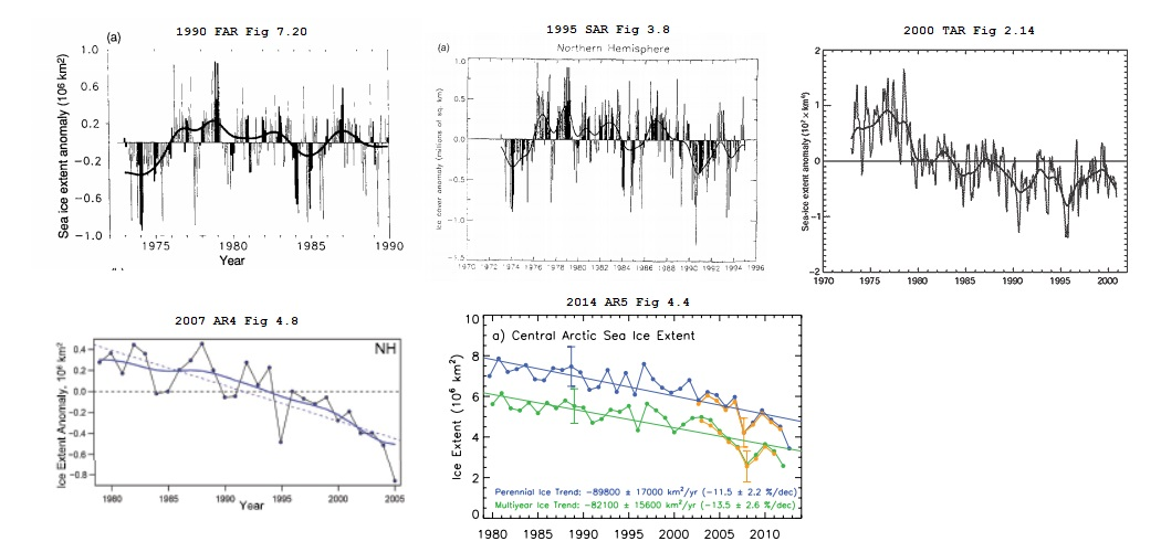
GM, Thanks for the reminder, here’s the progression of that through all five IPCC reports
comment image

Curious George
Reply to  Gerald Machnee
May 13, 2021 7:22 am

Read Orwell’s “1984” again. The Ministry of Truth “disappears” any inconvenient data.

Reply to  Curious George
May 13, 2021 8:08 am

In Orwell’s Animal Farm the pigs incrementally changed the seven commandments for animals until there was just one that said, “All animals are equal but same are more equal than others” Or something like that.
comment image

Gary Pearse
Reply to  Gerald Machnee
May 13, 2021 11:01 am

I’ve flown over the Arctic Ice at 40,000ft on three occasions going to Beijing from Toronto – past the east coast of Greenland over the Arctic Basin and across Siberia. I’m sure a lot of good info is available on ice from military and commercial flights and from shipping and exploration trips over a century, and of course the space programs since the 60s. But if course the climate wroughters dont want to know.

ed gruberman
Reply to  Gary Pearse
May 14, 2021 3:57 pm

So there is no ice?

Eisenhower
Reply to  Gerald Machnee
May 13, 2021 2:27 pm

There are plenty of shady statistics the government produces and should be called out on, but I don’t believe this is one of them. The high number of fires in the 1st half of 1900’s is an artifact of bad government policy. When the US outlawed prescribed fires most landowners and local governments continued the practice in violation of Federal law. The feds counted these controlled burns as wildfires causing the massive spike fire numbers and acres burned. By 1930’s scientific publications were documenting the environmental damage being done by Federal policy. By 1940’s the feds had completely turned 180 degrees and began official prescribed burning again and these fires were no longer counted in official wildfire numbers.
 
Here is some more on history of fires and explains some of the policies that led to this statistical artifact. https://www.researchgate.net/publication/239590838_The_History_of_Fire_in_the_Southern_United_States

David A
Reply to  Eisenhower
May 16, 2021 7:51 am

“The high number of fires in the 1st half of 1900’s is an artifact of bad government ”

As is the increase in the cherry picked portion of the graphic. Due to government policy limiting Forrest management and ecological logging. Also only a portion of the larger fires was due to controlled burns. The fires were often far larger. Suppression led to overgrowth, and overgrowth and government policy to worse fires lately.

Zig Zag Wanderer
Reply to  Gerald Machnee
May 13, 2021 2:33 pm

Gerald Machnee
May 13, 2021 6:08 am
just like the Arctic Ice data before 1979.

Last edited 6 hours ago by Sunsettommy

I’m curious. How did sunsettommy edit Gerald Machnee’s comment?

Tom Abbott
Reply to  Zig Zag Wanderer
May 13, 2021 2:55 pm

sunsettommy is a moderator. It looks like he was just trying to help Gerald out.

(Yes I corrected his numbers for him, it was 1079, now 1979) SUNMOD

Zig Zag Wanderer
Reply to  Tom Abbott
May 13, 2021 10:20 pm

Oh, thanks.

May 13, 2021 6:08 am

You pretty much cannot find this chartcomment image
unless you know where it is, because this page:
https://www.fs.fed.us/research/sustain/criteria-indicators/indicators/indicator-316.php
where it used to be was scrubbed of content.

Citizen Smith
Reply to  Steve Case
May 15, 2021 2:12 pm

Last October, after listening to Governors Brown and Newsome declare “Climate Fires” were the new norm, I was able to download numbers from the NIFC and made these graphs. There was a disclaimer that said ” Prior to 1983, sources of these figures are not known, or cannot be confirmed, and were not derived from the current situation reporting process. As a result the figures prior to 1983 should not be compared to later data.” It is obvious that the method for counting the number of fires changed at that time. Counting fires can be tricky. thousands of fires can be started by a single lightning storm. Obviously, they can not all be counted let alone discovered.

climate Fires.JPG
David A
Reply to  Citizen Smith
May 16, 2021 7:53 am

Far easier to count fires now, and tropical depressions and storms as well.

David Guy-Johnson
May 13, 2021 6:11 am

Cherry picking par excellence

SMC
May 13, 2021 6:13 am

Rewriting history to support the narrative is what tyrants have been doing for millennia. Why should the current crop of communists currently in power be any different?

Keith Harrison
May 13, 2021 6:16 am

Disgusting! A harbinger of more radical actions to come by government that has lost its reason to be. Accepting reality is anathema today.. Cancel Culture is rife in science and culturally. Such a shame that we need to pass through such a phase.

May 13, 2021 6:20 am

Glad to see more detailed exposure to government climate data fraud, manipulation, and blatant hypocrisy (to name just a few). My short video catches Joe red-handed in this data fraud … https://newtube.app/user/RAOB/KX3Jgsm

Reply to  John Shewchuk
May 13, 2021 6:42 am

You should put it up on You Tube as well. If You Tube deletes it, then that will become part of the preponderance evidence against the Climate Crusaders that will eventually (probably after I’m long dead) come out.

Reply to  Steve Case
May 13, 2021 6:53 am

Steve. Thanks for your concern. I did post it there (link follows). As soon as YouTube realized I was trying to expose climate fraud, they started shadow-banning my YouTube site. Also, when ever I make a comment to someone else’s content, YouTube immediately erases my comments! Anyway — here’s the YouTube video link … https://www.youtube.com/watch?v=vRvnMmgJuIk&t

Jimmie Dollard
Reply to  John Shewchuk
May 13, 2021 10:19 am

Well done. Thankyou

Jan de Jong
May 13, 2021 6:22 am

If you follow Tony Heller you know all this (and more).

Reply to  Jan de Jong
May 13, 2021 6:33 am

Heller is finally beginning to gain traction on YouTube. It will be very difficult to rebury the lies and manipulation of the historical record he has exposed.

Reply to  Graemethecat
May 13, 2021 7:30 am

Tony Heller has been on top of the climate establishment’s data tampering for a long time. He also does a great job of searching historical periodicals and the literature for articles that both corroborate the untampered data and illustrate how the “climate science” zeitgeist has evolved over time.

For some reason, he doesn’t seem to get the wider coverage he is due. Maybe he’s too much of a lightning rod for some skeptics, but that seems contrary to recent articles here that skeptics need to take off the kid gloves and pick up their game.

John Hultquist
Reply to  Frank from NoVA
May 13, 2021 9:09 am

“does a great job of searching historical periodicals and the literature “

a. Yes, very good at this.
b. Takes great photos.
c. Never sleeps.
d. Can get cranky.
e. I mostly avoid videos.

Gary Ashe
Reply to  John Hultquist
May 13, 2021 9:48 am

” I mostly avoid videos.” then you are an idiot.

Zig Zag Wanderer
Reply to  Gary Ashe
May 13, 2021 2:38 pm

” I mostly avoid videos.” then you are an idiot.

I mostly avoid videos too. I’m literate, and much prefer reading.

I have to assume that you are illiterate to make such an accusation.

H.R.
Reply to  Gary Ashe
May 14, 2021 1:47 pm

I can only watch videos with closed caption. No cc? It’s usually pointless to watch if it’s just someone talking.

And the videos with voice generated cc can be very difficult because I have the added fun of trying to figure out the mangled text of what was said, all the while the video keeps chugging along. Consequently, I don’t watch many videos.

Reading? I get instantaneous pause and rewind 😜

So… I’m an idiot?

Reply to  John Hultquist
May 13, 2021 1:40 pm

The Ministry of Truth hates him — which means he’s over the target.

David A
Reply to  John Hultquist
May 16, 2021 7:55 am

I understand that John. Me too. Yet his videos are quite shirt an well done.

Reply to  Frank from NoVA
May 13, 2021 10:12 am

“skeptics need to take off the kid gloves and pick up their game”

exactly! it’s the real battle to save our economy and freedom

Reply to  Joseph Zorzin
May 13, 2021 1:41 pm

This is for the skeptics … https://www.youtube.com/watch?v=Xcc5-ApXFm8

Reply to  Graemethecat
May 13, 2021 7:51 am

Tony Heller had long ago “gained traction” on Youtube, but has been repeatedly kicked off that Marxist propaganda train.
You can watch his stuff on Newtube now
https://newtube.app/TonyHeller
In six months he has nearly 15000 subscribers and nearly 2 million views.

Reply to  Timo, not that one
May 13, 2021 10:14 am

for a long time, YouTube locked his subsriber count to 99,000- they finally let it rise and it’s now just over 100,000 but they’ve threatened to lock him out- I think his work complements this blog very well

Scissor
Reply to  Jan de Jong
May 13, 2021 8:57 am

Yes and if Tony had received a nickel for every ad hominem attack that he’s had to endure, then he would have quite a fortune.

He’s been a warrior for the climate truth fighting against lies such as shown above.

WBrowning
Reply to  Jan de Jong
May 13, 2021 10:05 am

Tony is an awesome source of Truth! Mostly he shows the true records from the past, or shoves their own words and works back in their faces as proven wrong.

Reply to  WBrowning
May 13, 2021 10:16 am

which of course is why they refuse to acknowledge his existence- to the alarmists- he is a “non person”- he should be invited on major talk shows- certainly at least on Fox

Reply to  Jan de Jong
May 13, 2021 1:29 pm

If you follow Tony Heller you know all this (and more).

And here’s where you can find Tony Heller, for those who missed out on the years ago shadow-banning of Tony from WUWT (because Tony dared to call the climate fraudsters what they were); this is Tony’s version of the above article (published in March 2021):

https://realclimatescience.com/2021/03/biden-administration-erasing-more-climate-history/

May 13, 2021 6:34 am

Here’s the number of changes NASA’s GISTEMP has made to their Land Ocean Temperature Index (LOTI) since 2020

2020
Jan Feb Mar Apr May Jun Jul Aug Sep Oct Nov Dec
319 240 313 340 298 404 319 370 303 389 381 370

2021
Jan Feb Mar Apr May Jun Jul Aug Sep Oct Nov Dec
330 468 338

Over time those changes add up. Here’s what that looks like since 2010:
comment image

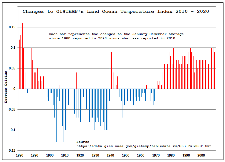
Here’s the link to the current data for GISTMP’s LOTI:
https://data.giss.nasa.gov/gistemp/tabledata_v4/GLB.Ts+dSST.txt

Reply to  Steve Case
May 17, 2021 4:34 am

Update, GISTEMP’s LOTI is out for April (follow the link above) and 256 changes have been made to what it had been for the March 2021 LOTI

These changes go on month after month in a steady drone.

May 13, 2021 6:35 am

I was born in 1942 in Ohio. I can clearly remember at least two summers that you could smell the smoke and the evenings where red from horizon to horizon from the fires “out west.” Don’t remember the years they happened, but was well before the peak shown in the 70’s above as I was in the Navy in HI then. Have never seen skies as red as that since then,

Reply to  Rich Lentz
May 13, 2021 10:17 am

When Yellowstone burned (1988???)- I could smell the smoke and see red skies here in MA

Andrew Kerber
May 13, 2021 6:36 am

Dont forget, the spotted owl logging restrictions kicked in at about the same time, no more logging roads (firebreaks), no more forest planning and pruning…

Reply to  Andrew Kerber
May 13, 2021 10:20 am

and no more thousands of good logging and sawmill jobs- I believe it was later shown that the spotted owls don’t really depend on old growth forests- the same kind of crazies are now saying here in New England that we should stop all forestry so the forests will have only one function- to sequester carbon- the hell with future generations that might like to live in wood homes with wood furniture- let them eat cake and build cement homes

another ian
Reply to  Joseph Zorzin
May 14, 2021 4:23 am
Cheshire Red
May 13, 2021 6:36 am

‘He who controls the past controls the future.’

Here it is, hidden in plain view.

ResourceGuy
May 13, 2021 6:46 am

The dirty tricks industrial complex never sleeps.

2hotel9
May 13, 2021 6:49 am

USG agencies lying about and removing historical data? I am shocked, SHOCKED I say!

Coeur de Lion
May 13, 2021 6:55 am

UK’s Royal Society says that regionally there have been some increases but globally no trend. They also say that deaths due to wildfires continue to fall. They mention ‘urban wilding’ as a factor- the tendency for increasing populations and prosperity to spread out into forested suburbs and a lack of associated clearance. The tragedy of Paradise CA was started by an electrical distribution fault and exacerbated by lack of escape routes.

May 13, 2021 7:01 am

 “The data prior to 1983 is no good, trust us”.

Nullius in verba! – motto of the Royal Society (take nobody’s word for it).

This sort of unscrupulous behaviour will be their undoing.

They might have got away with erasing pre-1950’s maybe, but the 1980’s? not a chance.

This fraud needs to be highlighted at any given opportunity around the subject of USA wildfires.

Tom Abbott
Reply to  Climate believer
May 13, 2021 8:11 am

“This sort of unscrupulous behaviour will be their undoing.”

Let’s hope.

Weekly_rise
May 13, 2021 7:07 am

From here, the early part of the dataset is not showing the same thing as the more recent part. In particular, the early data seem to be showing area burned for both intentional burns and wildfires, while the later data are showing area burned for wildfires only.

Reply to  Weekly_rise
May 13, 2021 7:29 am

That doesn’t seem to be the case. That’s just the bloggers interpretation. But following the link from the blogger he appears to be mistaken.

The graph is there in the link (figure 6 on page 35 of the PDF).:
https://www.fs.fed.us/research/sustain/docs/national-reports/2003/data/documents/Indicator%2015/Indicator%2015.pdf

Also I quote from just above the graph:

Following the massive wildfires of 1910 in the Northern Rocky Mountains, fire protection improved and eventually reduced destructive wildfires by more than 90 percent: from 20–50 million acres per year to 2–5 million acres (Frederick and Sedjo 1991, Powell and others 1994) (Table 3, Figure 6). 

Which implies that the source the blogger mis-understands is quite willing to compare the two halves of the graph.

Weekly_rise
Reply to  M Courtney
May 13, 2021 8:05 am

On the contrary, the blogger is exactly right. From the same paper, in reference to figure 6:

Between 1930 and 1950,in excess of 10 million acres were burned by wildfires annually. Most of the area burned during this period was in the Southeastern United States (South RPA Region) and were primarily incendiary fires.

As I stated, the earlier data shows primarily intentional burns, while the latter half shows are burned by wildfires.

Reply to  Weekly_rise
May 13, 2021 9:45 am

How many “wildfires” are incendiary fires ? Remember Australia….

Robert of Texas
Reply to  Weekly_rise
May 13, 2021 9:54 am

I just looked up the definition of “Incendiary Fire” : A fire intentionally ignited under circumstances where the person knows the fire should not be ignited.

That us not the definition of a controlled burn. Most modern fires would also be classified as “incendiary fires” as they are started by people. So they are comparing the same thing in the older data as the newer data.

Weekly_rise
Reply to  Robert of Texas
May 13, 2021 11:02 am

It would certainly include “illegal controlled burns,” and certainly means the older data includes more than simply wildfires.

MarkW
Reply to  Weekly_rise
May 13, 2021 11:20 am

Since the modern data also contains “illegal controlled burns”, why the desire to only toss the data that doesn’t support what you want to believe?

Weekly_rise
Reply to  MarkW
May 14, 2021 1:09 pm

I think the modern data does not include these kinds of illegal controlled burns. During the 1930s, the US Forest Service had banned all forms of prescribed burning, and they considered any form of such to be an incendiary wildfire. As others in the thread have pointed out, most of the burn area reported in the old NIFC graph is from the Southern States, where woods burning was a cultural practice with a long history predating European settlement. Since the Forest Service began adapting prescribed burning in the mid 20-century, they would not have classified any prescribed burning of Southern forests as wildfires.

Again, the issue seems to be that the data from ~1930s is showing something entirely different than the data after.

Reply to  Weekly_rise
May 13, 2021 2:01 pm

Dude, the text explicitly says that “fire protection improved and eventually reduced destructive wildfires by more than 90 percent” and that’s what the graph shows. Apples to Apples,

The blogger either didn’t read his own source or lied to you.
Either way, be more sceptical.

Lrp
Reply to  Weekly_rise
May 13, 2021 11:45 pm

Are you a pretzel?

MarkW
Reply to  Weekly_rise
May 13, 2021 9:24 am

If that was true, why not fix the older data, rather than just throw it all out.

Weekly_rise
Reply to  MarkW
May 13, 2021 9:45 am

The older data aren’t wrong, they’re just showing a different thing. Combining them with the more recent data and claiming that you’re showing historic trends in true wildfires is misleading.

MarkW
Reply to  Weekly_rise
May 13, 2021 10:24 am

Nice dodge.
I never said that the older data was wrong.
If they know that the older data contains data from controlled burns, then remove the controlled burns from the older data. That way you are now comparing like to like.

Now answer the question, why don’t they fix the data instead of just throwing it out?

I think we both know the answer to that question, and the answer is the fixed data doesn’t support the goals of the climate change warriors.

Weekly_rise
Reply to  MarkW
May 13, 2021 10:44 am

You’re making an assumption that there is actually a way to seperate out the historic controlled burn area from the total area burned, which is not necessarily true.

You “think you know” the answer not because of any documented evidence, but because you have a strongly held preconception. This is not a scientific mindset.

MarkW
Reply to  Weekly_rise
May 13, 2021 11:17 am

If they know which fires were arson, then they know how big those fires were. The data is there for those who want to go look for it.
Refusing to look because the results might not support what you want to believe isn’t very scientific.

Reply to  Weekly_rise
May 13, 2021 12:29 pm

So, you are saying the controlled burn area is a significant part of, say, 30,000,000 acres average through that time frame?

Do you want to subtract the arson caused fires from the recent acreage as well?

paul courtney
Reply to  Weekly_rise
May 13, 2021 10:54 am

Mr. rise: Not misleading when presented in response to the alarmists meme that AGW is making wildfires worse. How hard is it to look at the numbers behind “primarily”? I recall reading of massive fires in WI, the midwest, and northwest in the crazy-weather ’30s, and it’s all there, why does he use the weasel word “primarily” when he could use math? Count me skeptical.
What we have here is data collected and charted by U.S. govt that sat quietly unnoticed. CliScis say AGW is increasing wildfires. The chart shows they lie, so Heller put it out there. The alarmists could have tried to go through old data to ferret out “intentional” acreage to dispute this, instead (great surprise) they throw out valid data to preserve their meme. Have you considered this- they DID ferret out that data and found it still put the lie to their catastrophe story? So it had to be pitched. It’s not misleading to lead folks away from false memes.

Carlo, Monte
Reply to  Weekly_rise
May 13, 2021 11:08 am

And there is still no hockey stick.

Bruce Cobb
May 13, 2021 7:18 am

“Four legs good, two legs bad.”
New data good, old data bad.

May 13, 2021 7:21 am

The graph going back to 1926 is not the whole truth. The data for earlier years includes prescribed burns because of an anti-fire attitude that the US Forest Service had back then. http://ti.org/antiplanner/?p=15127

Reply to  Donald L. Klipstein
May 13, 2021 8:10 am

So the amount of acreage burned has something to do with what starts the fire? OK, then remove all arson and accidential fires from the current records too.

Reply to  Doonman
May 13, 2021 9:04 am

That’s 80% according to NIFC.

Windsong
May 13, 2021 7:34 am

One problem with NIFC statistics is that the reporting Federal agencies (NFS, NPS, BLM, DOD, etc) and the states/territories do not report all fires in the same manner. Some states report County and Local (C&L) fires, like a vacant lot set on fire from fireworks, some do not. Easy to pad the numbers when the threshold for a wildland fire is .1 (one-tenth) acre. For example, in my home state of Washington, the National Park Service reported to NIFC four lightning caused fires in 2020. The four fires burned a total of .8 (eight-tenths) acre. NPS in New Mexico reported eight fires burning ten acres for the same category in 2020. But my favorite example is NPS in Utah; in 2020 three lightning fires burned zero acres.
https://www.predictiveservices.nifc.gov/intelligence/2020_statssumm/fires_acres20.pdf
Obviously the above examples are in high elevation, inaccessible terrain. Read any of Stephen J. Pyne’s recent books for a detailed look at how civilization encroaching relentlessly into fire adapted ecosystems, like much of the Western US, has caused huge, unintended consequences.

CD in Wisconsin
May 13, 2021 7:34 am

https://californiapolicycenter.org/environmentalists-destroyed-californias-forests/

“Up until the mid-1970s, we managed our national forests according to well-established and time-tested forest management practices. But 40 years ago, we replaced these sound management practices with what can only be described as a doctrine of benign neglect. Ponderous, Byzantine laws and regulations administered by a growing cadre of ideological zealots in our land management agencies promised to save the environment. The advocates of this doctrine have dominated our law, our policies, our courts and our federal agencies ever since.”

********

Article is dated September 2020, so 40 years before that would be around 1980. The forest fire data that the NIPC now shows starts going up in 1983.

Enough said.

Reply to  CD in Wisconsin
May 13, 2021 10:21 am

and people now wonder why lumber prices keep going up

Kevin kilty
May 13, 2021 7:53 am

In Bradbury’s Fahrenheit 451 inconvenient books were burned by firemen. The present analogy is disappearing inconvenient data. Perhaps it is time to take a page from 451F, which had those keepers of the books, and everyone maintain a small depository of present data regarding, say, climate and weather, policing and crime, tax receipts and expenditures, health, demographics, agricultural production, and so on.

Whatever you are interested in.

Al Miller
May 13, 2021 7:54 am

Right out of Lenin’s playbook- lie cheat and steal whatever it takes to “win”.

establ
May 13, 2021 7:57 am
May 13, 2021 8:00 am

At some point, people will realize that Arrhenius, Ekholm and Callendar used the same unreliable data, equipment and measurement techniques in all their work because it could not possibly be reliable when they were alive.

That invalidates the entire premise of global warming, so remove it all from the libraries.

May 13, 2021 8:05 am

Remember this?

Scientists are frantically copying U.S. climate data, fearing it might vanish under Trump
https://www.washingtonpost.com/news/energy-environment/wp/2016/12/13/scientists-are-frantically-copying-u-s-climate-data-fearing-it-might-vanish-under-trump/

Reply to  jarves
May 13, 2021 9:23 am

The key sentence “Investors offered to help fund efforts to copy and safeguard key climate data”….So really a plan for green-fleecing investors that sounds ‘truthy’ to Democrats.

paul courtney
Reply to  jarves
May 13, 2021 10:17 am

Mr. jarves: Thanks for the memory, I do recall that news. I remember thinking that copying data would not make them frantic, point-n-clic. It was the groups deleting the list of fake-name email accounts that was frantic.

MarkW
May 13, 2021 8:07 am

Sort of like climate scientists who start recording temperatures during the Little Ice Age.

May 13, 2021 8:40 am

There is much evidence showing fires were worse 100 years ago.

Climate alarmists have been dishonestly trying to make a connection between climate change and fires for decades, simply to induce unwarranted fear and gain political power, by cherrypicking the start dates for their trends, ignoring the role of increased human ignitions, ignoring the spread of highly flammable invasive grasses, not addressing fuel build up from fire suppression, or the fact that maximum temperatures were higher in the 1930s where most western USA wildfires have started . Read http://landscapesandcycles.net/minimizing-california-s-wildfires.html

Acre of wildfire burned PDO.jpg
Reply to  Jim Steele
May 13, 2021 8:42 am

From Swetnam 1996

Swetnam Southwest fire frequency 300 5 in.jpg
Reply to  Jim Steele
May 13, 2021 9:36 am

from 63 sites and a 300 year period, obviously cherry picked pseudo science by deniers….according to the Climate Liars Club of the Americas, the CLCA. /sarc

May 13, 2021 8:53 am

Trying to compare annual fire seasons by acreage burned is like trying to measure the strength of hurricanes by the number of people displaced. It all depends on where it happens, and how it is managed. In California it seems clear that the philosophy of fire fighting is no longer aimed at putting the fire out as quickly as possible. The new philosophy is to manage the fire away from structures as much as possible, and let it burn itself through the deadwood covered forests as it would naturally do. I believe this is why fires last for several weeks now instead of several days. It has nothing to do with any change in climate. And a burgeoning homeless population doesn’t help.

From today’s Los Angeles Times:
On Wednesday a Los Angeles Times investigation revealed that, among other things, fires related to homeless encampments have nearly tripled. According to the paper, in the first four months of this year there were 24 such blazes a day. Those calls accounted for 54% of all fires responded to by LAFD.

May 13, 2021 9:06 am

Any data collected before the internet, was recorded by human beings in old-fashioned logbooks, and probably cannot be trusted. It must be entered in a database, vetted for possible human or instrumentation bias and adjusted accordingly, preferably annually, and new graphs of the ‘historical readings’ need to be published, and the database updated.
Anybody knows their grandfather wasn’t reliable with numbers.
/s

Mr.
May 13, 2021 9:14 am

Just like Canada doesn’t use temps records prior to 1950, and Australia quit pre-1910 records.

Because if you look at their entire records since they started taking them, there’s no real “heating” to talk about.

John Hultquist
May 13, 2021 9:23 am

 After a fire there is often an on-the-ground study of the extent and severity of damage to soil, plants, and animals. Such reports follow about a year after the incident is over.
You have to search for these because the news will have gone through ~364 new crises in the interval.
If possible, find a report for an area you know.

May 13, 2021 9:29 am

“Why would they do this you ask?”

Because, as they have been saying for some time, they don’t believe it is true, and aren’t prepared to put their name to it? Why do we believe the contrary? Where did this data in fact come from? Who does put their name to it?

The early figures are just nonsensical. In the years around 1930, it has 50 million acres a year being burnt. That is the area of Nebraska. A fortieth of the area of ConUS (and the early figures apply only to ConUS) burnt in just one year. And the same the next, and the year after and so on. There is no actual history of these massive conflagrations. You could not burn a Nebraska every year without massive loss of life.

So again, where did these numbers actually come from? Why should we believe them if the NIFC does not?

John Phillips
Reply to  Nick Stokes
May 13, 2021 9:57 am

According to some digging done by ATTP,

““Between 1930 and 1950, in excess of 10 million acres were burned by wildfires annually. Most of the area burned during this period was in the Southeastern United States (South RPA Region) and were primarily incendiary fires. Since 1960, between 2 and 5 million acres were burned annually by wildfires. […]

So it appears that much of the pre-1960 data were related to incendiary forest fires (per http://www.interfire.org/features/wildfires.asp, an incendiary fire is one that is set intentionally) and not to true wildfires. The post-1960 dataset that I analyzed only contained data for wildfires; the National Interagency Fire Center explicitly separates the wildfire data from the prescribed fire data.”
 
https://andthentheresphysics.wordpress.com/2015/10/30/the-mysterious-wildfire-chart/
 
So, it is apples and onions. Apparently pre-1960 they counted deliberately-set fires, after that just spontaneous ones.

MarkW
Reply to  John Phillips
May 13, 2021 10:27 am

incendiary fires refers to arson, not controlled burns.
Modern statistics includes arson fires.
The early data is measuring the same thing as the newer data.

John Phillips
Reply to  MarkW
May 13, 2021 11:42 am

Um, no. The early data is all fires, whether deliberately set (prescribed) or not More recently the National Interagency Fire Center explicitly separates the wildfire data from the prescribed fire data.

The wildfires are linked in the head post, prescribed fires are detailed here: https://www.nifc.gov/fire-information/statistics/prescribed-fire
 
A common complaint around here is climatologists splicing mismatched datasets to obscure inconvenient trends. Here we have a splice of two incompatible datasets ……

paul courtney
Reply to  John Phillips
May 13, 2021 12:39 pm

Mr. Phillips: First you quote ATTP, i could have stopped there but didn’t. He simply repeats the same quote including two weasel words- “most of the area” and “primarily”, to effectively remove math from the discussion. ATTP did no digging at all, he simply repeated the quote that is patently NOT a reason to delete data (and he’s the physics guy?). The data is not apples and oranges, not incompatble, because both sets include wild fires. A little “digging” (not the ATTP version, actual digging) could yield apples to apples, but no, jsut hide it from the public that pays you.
Please try to do better if you are gonna gaslight.

Reply to  John Phillips
May 13, 2021 12:43 pm

Incendiary Fire. Wildland fires set intentionally often begin in accessible areas because they are easily reached, but often lightly traveled–and therefore the firesetter is less likely to be discovered.

The above is from your reference article…it is arson.

You are misleading (lying) when you try to conflate arson with prescribed burns. Either that, or you are an idiot.

John Phillips
Reply to  DonM
May 14, 2021 11:01 am

You’ve swerved the central point in favour of abuse.

Early data=all fires
Later data = all fires minus prescribed fires.
 
Apples/Oranges. I cannot make it simpler than that.

paul courtney
Reply to  John Phillips
May 14, 2021 2:08 pm

Mr. Phillips: And if we try to extract the prescribed fires from the early data and it shows a trend that contradicts AGW scripture, better scrub it all. I can make that simpler- don’t throw the baby out with the bathwater. Tell that to Ken.

Reply to  John Phillips
May 14, 2021 5:17 pm

“… whether deliberately set (prescribed) or not …”

My central point is that you are intentionally (or through an inability to understand) conflating ‘prescribed’ with ‘arson’.

Is it a mistake, or you are you incompetent.

Now, since you can’t (or won’t) acknowledge the mistake … should throw out everything you have said, except for the parts that make you look bad? Or should we do something else?

Mr.
Reply to  Nick Stokes
May 13, 2021 10:13 am

Nick, how naive are you?
The NIFC has an organizational incentive to cook the records in their jurisdiction..
This aligns their narrative with the whole-of-government AGW narrative.
They wouldn’t want to be out of step with their bosses.

Reply to  Mr.
May 13, 2021 11:23 am

The NIFC reported data from USFS annual summary reports that counted intentionally set fires for controlling vegetation as wildfires. The large number of reported acres burned in the first half of the 20th century comes from these reports on unprotected lands.

Short Karen C. (2015) Sources and implications of bias and uncertainty in a century of US wildfire activity data. International Journal of Wildland Fire 24, 883-891.
https://doi.org/10.1071/WF14190

Reply to  Nick Stokes
May 13, 2021 10:57 am

You’re right of course. Lets go with your theory that a rise of 0.5ºC of the global average temperature starts fires. Much more plausible.

MarkW
Reply to  Right-Handed Shark
May 13, 2021 11:27 am

Since they are only looking at data since 1985, the rise in temperature is actually more like 0.2C.

Reply to  MarkW
May 13, 2021 12:40 pm

Sorry Mark, I was looking at the adjusted data. 😉

paul courtney
Reply to  Nick Stokes
May 13, 2021 11:15 am

Mr. Stokes: “There is no actual history of these massive conflagrations.” Have you looked? Bet not. Mr. Heller is great for pulling up old news articles from that time, backing up his charts. I know you don’t go to his site or you would not expose yourself to such a debunking. Then again, you were the guy who said the ice age scare of the 70s was purely news articles, no scientists. You got debunked pretty hard there. Please take this opportunity to research the “actual history” of which you are ignorant, before somebdy less nice calls you on it.

Reply to  paul courtney
May 13, 2021 2:30 pm

OK, let’s have some history. Where were these huge Nebraska-sized fires in the ’30s?

paul courtney
Reply to  Nick Stokes
May 14, 2021 7:39 am

Did you miss the part about Mr. Heller’s site?

Reply to  paul courtney
May 14, 2021 11:56 am

Can you answer the question?

paul courtney
Reply to  Nick Stokes
May 14, 2021 2:12 pm

Mr. Heller likes to show charts AND news articles supporting the charts. Did answer. Obtuse is a look you prefer.

Reply to  Nick Stokes
May 14, 2021 9:25 am

Here’s one from 1910 which dwarfs any recent fire:

https://en.wikipedia.org/wiki/Great_Fire_of_1910

Reply to  Graemethecat
May 14, 2021 9:38 am

That fire totaled ~3 million acres, and you’re right. That was a huge fire. According to the USFS, two years in the early 1930s exceeded 50 million acres each year. So there must have been the equivalent of 16 of those Big Burn fires during those years. Let’s see you find historical evidence of these.

paul courtney
Reply to  Nick Stokes
May 13, 2021 11:17 am

Maybe “they” don’t believe it’s true because “they” overlook “actual history” just like you?
Sorry, couldn’t stay nice for too long.

MarkW
Reply to  Nick Stokes
May 13, 2021 11:25 am

Fascinating how Nick feels that any data that doesn’t pass his plausibility test needs to be tossed.

On the other hand, data that supports the position Nick is paid to support, no matter how implausible it sounds to others, has to be kept.

Reply to  MarkW
May 13, 2021 2:32 pm

The NIFC feels that any numbers that they can’t accept as reliable shouldn’t be on a website that they are responsible for.

Who said it is “data”? Who measured it? How?

GregB
Reply to  Nick Stokes
May 13, 2021 4:31 pm

Apparently the NIFC said it was data until a couple of days ago, when they said it wasn’t data anymore.

And don’t you think a more intellectually honest way to handle this would be to keep the data, and then add shading, or a comment that says something like “we suspect the data pre-1983 isn’t reliable due to X, Y, and Z factors.” Perhaps even give rationale like you’re suggesting.

But simply eliminating the data, especially at a low point, screams manipulation for narrative’s sake.

Finally to your point about “Nebraska Sized Fires”. First, I’m sure you’ll agree that it’s not one contiguous fire. Second, perhaps 50MM acres is erring on the high side. But is 40MM acres plausible? 30MM? If the NIFC had provided more rationale for eliminating it, we could make a judgement.

I think the point of the article is that eliminating data with essentially no fact or science-based rationale is pure manipulation. Have to believe you would agree with at least that much.

Reply to  GregB
May 13, 2021 4:38 pm

“Apparently the NIFC said it was data until a couple of days ago”

The article doesn’t say when it finally disappeared. But it does note the caveat that they had been showing for years:

“…Prior to 1983, sources of these figures are not known, or cannot be confirmed, and were not derived from the current situation reporting process. As a result the figures prior to 1983 should not be compared to later data.”

A very natural question is, if you can’t back the figures and don’t think they are comparable, why are you showing them as data? So they decided not to.

GregB
Reply to  Nick Stokes
May 14, 2021 7:21 am

My response would be, where did the data come from in the first place? Was it just wild-ass guesses? Invented data?

Probably not. It clearly came from somewhere. And so saying “sources of the figures are not known” is highly suspect.

In other words, it sure seems like the NIFC is saying “we showed up one day and the data was here already. But after a while, we decided that maybe we shouldn’t use data that we don’t know the origin of.”

if you can’t back the figures and don’t think they are comparable, why are you showing them as data?”

If you can’t back figures, and then decide to remove them, I would think more explanation than “sources are not known” would be more than in order.

Reply to  GregB
May 14, 2021 11:58 am

“My response would be, where did the data come from in the first place?”
I explained that below. It comes from data published by the census bureau. And the vast majority of the fires of that period are shown as in unprotected areas. And of that, the source has a note saying:
“No field organizations are available to report fires on unprotected areas and the statistics for these areas are generally the best estimates available.”
So yes, they showed the best estimate available. That is your data.

Lrp
Reply to  Nick Stokes
May 14, 2021 2:53 pm

Breathtaking dishonesty; on this principles you can erase any history, just because you “feel” it doesn’t fit your narrative. As for responsibility, it’s irresponsible to alter data and records, but you wouldn’t know that.

Reply to  Lrp
May 14, 2021 3:18 pm

No-one is altering data and records. The original records were in Government publications, summarised in the published Census Bureau data. The NIFC used them as the basis for a graph, with caveats, but then decided they could not vouch for its accuracy. It was never their data. The data is still where and as it always was.

paul courtney
Reply to  MarkW
May 13, 2021 2:44 pm

Mr W.: It has a familiar ring to it…… old data incomplete, “not up to today’s standards”; after applying scientific adjustments, OMG it’s worse than we thought, exactly as we predicted. Did they have to delete it, couldn’t they apply adjustments to make the old forest fires shrink? Mr. Stokes would be ok with it.

Jimmie Dollard CJ52
Reply to  Nick Stokes
May 13, 2021 4:27 pm

I believe that discrediting fire data before 1983 is an insult to the dedicated men and women of the USFS. I fought fire in the early ’50s both as a ground crew on large fires and as a smokejumper on small fires. We were trained to carefully measure the size of the fires and included this in the report we signed. We were warned to be accurate because someone from the district would later check out the site using our report. These reports get rolled up into district then forest then national reports. These are real reports, all signed and I am sure the NIPC had access to them. They did not include data before 1983 because they did not support their narrative-period.

In those days District Rangers and even Forest Rangers wore logging boots and prided themselves spending more time in the forest than the office. They had fire data prominently displayed on their bulletin boards. They faithfully kept all records with a pencil, but to say it wasn’t reliable is an insult. From these old timers I heard a lot stories of horrific fires of the 1930s in both NW and Midwest. If you really doubt the amount of acres burned read about the fires in 1910. Several are available but my favorite is: “The Bib Burn- Fires of 1910”. Or you could put on a pair of boots and walk into any forest in the West, SE, or Midwest and look at the burned out stumps for yourself. Part of our fire training included study of the 1910 and the 1930 fires. I believe these old records are accurate, though you could quibble about definitions but that won’t significantly change the area burned.

Reply to  Jimmie Dollard CJ52
May 13, 2021 6:44 pm

“I believe that discrediting fire data before 1983 is an insult to the dedicated men and women of the USFS.”

In fact it isn’t the land that the USFS covers that is in doubt. The original numbers came from this US statistical compilation. The relevant table p537 is here:
comment image

The numbers in protected areas are small, comparable to modern. The huge inflation is in unprotected areas, and of those the source notes:

“The source publication also presents information by regions and States on areas needing protection, areas protected and unprotected, and areas burned on both protected and unprotected forest land by type of ownership, and size of fires on protected areas. No field organizations are available to report fires on unprotected areas and the statistics for these areas are generally the best estimates available.” (emphasis mine)

The data was discredited at its source.

Reply to  Jimmie Dollard CJ52
May 13, 2021 10:44 pm

” If you really doubt the amount of acres burned read about the fires in 1910. Several are available but my favorite is: “The Bib Burn- Fires of 1910”.”

I did look up the Big Burn Fires. Here is what the University of Idaho had to say:

“During the August of 1910, a massive wildfire destroyed three million acres of land in Washington, Idaho, and Montana. The Great Fire of 1910 is believed to be the largest, although not the deadliest, forest fire in U.S. history. Smoke from the fair was said to be seen as far east as New York and as far south as Denver, Colorado. 

Seven small towns in Idaho and Montana were completely destroyed by the fire, and one third of Wallace, Idaho burned to the ground.”

Largest forest fire in US history. Towns destroyed. And the acreage burned? 3 million acres.

Yet this “data” says 50 million acres a year were burned during the early 1930’s. Each year.

paul courtney
Reply to  Nick Stokes
May 14, 2021 7:44 am

Mr. Stokes: So the data from 1910 about the size of fires trumps the data from the 1930’s?

Reply to  Jimmie Dollard CJ52
May 14, 2021 1:51 pm

Well said Mr Dollard, I was just reading about “smokejumpers”, brave men.

One might reasonably presume that the onus would be on those undermining historical data to explain why they think it’s not fit for purpose.

What was happening back in the 30’s, 40’s and 50’s that makes this data so valueless? and surely logically makes all data from those time periods suspect.

They say it was all “estimates”, like it was some big guessing game from people without a clue, a pathetic excuse.

To dismiss the work of those people without proper explanation is contemptible, but unfortunately that’s totally acceptable these days for the modern arrogant scientist.

Photo 1950.

https://ibb.co/Mf1d3NC

Reply to  Climate believer
May 14, 2021 2:17 pm

“They say it was all “estimates””
Who said that? Not the NIFC in 2021. It was the original source of the data, Census bureau, about 1970. That is where it all comes from.
comment image


Reply to  Nick Stokes
May 15, 2021 1:00 am

I know where it comes from, I was referring to your use of it as some kind of definitive proof of something unworthy and instantly dismissable.

Many things today are still “best estimates”, it is a valid position, it’s used all the time.

You’re very apt at taking the debate off into the weeds Mr Stokes, and you know very well which buttons to press on this site to get the desired effect.

I still haven’t seen an explanation of the Foresters methods for calculating number of burnt acres, and then an explanation of why it is now deemed non-valid.

This would be an honest way of allaying suspicion don’t you think?

Reply to  Climate believer
May 15, 2021 2:04 am

“I still haven’t seen an explanation of the Foresters methods for calculating number of burnt acres”

It’s quite possible that the estimate was not done by Foresters. It is likely that no-one, including NIFC knows how it was done, and therefore what it means. NIFC cannot then properly post the numbers along with the recent data. They can’t post on the basis, “well, they are numbers, aren’t they, and we’re not sure they are inconsistent”.

Reply to  Nick Stokes
May 15, 2021 9:26 am

It’s quite possible that the estimate was not done by Foresters. It is likely that no-one, including NIFC knows how it was done, and therefore what it means.”

That is highly improbable considering the amount of Forest Service archived material in the National Archives Catalog going back to 1870.

As I said before, you are trying to portray those years as something akin to a dark age, but those records prove that not to be the case at all, and in fact show people to be very meticulous with a keen sense for detail in all parts of forest management.

Reply to  Climate believer
May 15, 2021 2:03 pm

From that quote again
“No field organizations are available to report fires on unprotected areas”
Somebody made an estimate. It could have been the organization compiling the statistics. About 90% of the acres in those 1930’s data were in unprotected areas.

Craig Moore
May 13, 2021 9:31 am
RobR
May 13, 2021 9:34 am

Nice detective work Anthony. Please consider adding a folder containing this and other “disappeared data.

Wade
May 13, 2021 9:41 am

Reminds me of China’s war against the “Four Olds”, led by the brainwashed student Red Guard. This was a destruction of old ideas, old cultures, old habits, and old customs. You have to erase history so that people won’t the truth about the past. Inconvenient facts that make Comrade leaders look bad must be denounced and destroyed. By denouncing it as racist, sexist, or whatever other -ist you can make up, the brainwashed minions will gladly destroy it.

I’ve seen it firsthand. I’ve seen statues that were in place for over a hundred years get denounced as racist, and then torn down. One day, quickly and suddenly, these statues were causing “mental anguish” to people, even though a few days early it caused no such problems for the same people.

The past has to be destroyed, otherwise people would think for themselves and find out the truth. Can’t have that.

Reply to  Wade
May 13, 2021 11:23 am

The parallels between the Cultural Revolution and today’s Cancel Culture are uncanny.

Reply to  Wade
May 13, 2021 11:27 am

In the case of Confederate statues, the Democrats are just erasing their racism by tearing down statues of other Democrats.

May 13, 2021 9:42 am

People were clearly much more stupider in olden times. And the didn’t have computers back then, so any numbers they added together would have been just a guess.
Seriously though, how do the people doing this sleep at night?

Bruce Cobb
May 13, 2021 9:47 am

“We have to get rid of the Medieval Warm Period”.

May 13, 2021 10:18 am

I posted my take on this a month or so ago. I worked for several years on a national forest with a very active fire program and performed burned area resonse analyses for several very large fires.

http://eschewhob.blogspot.com/2021/01/further-reflections-on-wildfire.html?m=1

May 13, 2021 10:21 am
Tom Abbott
May 13, 2021 10:25 am

Who is going to write the book: The Great Human-caused Climate Change Fraud”?

It looks like we need to gather together all the Lies the alarmists use to perpetrate this fraud on the world in one book.

The entirety of the fraud is made of of distorted data. And the fraud cannot be continued without continuing to use fraudlent data.

Human-Caused Climate Change is the biggest fraud in human history and the wildfire data is just a continuation of the lies.

Somebody ought to go to jail over it.

May 13, 2021 10:36 am

The following should dispel some of the misinformation in this post. Most of the early data we have about wildfires comes from the USFS annual summary reports, and there is no consistent definition for what counts as a “wildfire” between sources. But it’s important to look first at the what these areas that burned were. The USFS fire data shows that the the peak in area burned in the early 20th century was due to burns that occurred on unprotected lands. If you look at trends on protected lands, area burned remains fairly steady throughout the the early 20th Century.[1]

Now if you look at the data for area burned within unprotected lands, almost all of it comes from the Southeast, Texas and Oklahoma – very little of it comes from the Western United States. And most of the area burned in the Southeast comes from just three states – Florida, Georgia and Mississippi.[1] What’s more, most of the areas burned in these unprotected lands were from woods-burning. They are what we now call “controlled” or “prescribed” burns, and they were intentionally set fires for controlling vegetation growth. These fires are still done today, but they are not reported as “wildfires” unless a prescribed burn goes out of control.

“In addition to the area-reporting bias in the USFS summary reports, analysts should be aware of other inconsistency and uncertainty in the wildfire activity estimates that are included, especially for unprotected areas. Intentional (‘controlled’) burning was used extensively for vegetation management on non federal lands, especially in the south-eastern US during the early 20th century. Although now used to a lesser extent (but on both federal and non-federal lands) in the US, intentional burning is not classified in the current reporting systems as ‘wildfire’ unless the controlled burn escapes and requires a suppression
response. However, the early USFS wildfire activity summaries do include millions of hectares of intentional burning on ‘unprotected’ lands, which, until approximately the mid-20th century was viewed by the USFS as akin to wildfire, as something that should be prevented and ultimately eradicated (Pyne 1982).”[2].

This is likely a significant reason why the NIFC isn’t showing data prior to 1983. There are inconsistencies in what gets reported as a “wildfire,” and accuracy in reporting requires consistent definitions of what gets reported as a wildfire. There’s no intentional hiding of data. This is just a case of bloggers not doing their homework.

[1] Short et al. USDA Forest Service Fire Data
https://www.fs.fed.us/rm/pubs_journals/2020/rmrs_2020_short_k001.pdf

[2] Short Karen C. (2015) Sources and implications of bias and uncertainty in a century of US wildfire activity data. International Journal of Wildland Fire 24, 883-891.
https://doi.org/10.1071/WF14190

wildfire data.png
Bruce Cobb
Reply to  Scott J Simmons
May 13, 2021 10:56 am

How convenient.

Reply to  Bruce Cobb
May 13, 2021 11:07 am

There’s also the matter of just how believable these numbers are. Think about it. This graph shows between 15 and 20 million hectares burning every year for about 15 years in a row. Let’s call that 250 million hectares for fun. That’s almost 1 million square miles, or more than the states of AL and CA combined. Most of the burned area on unprotected lands comes from FL, GA, and MS – that’s a total of 173 square miles. That’s ludicrous. These summaries are not providing straight up wildfire numbers.

paul courtney
Reply to  Scott J Simmons
May 13, 2021 1:01 pm

Mr. Simmons: Uh huh. Thanks for the careful review. So NIFC deletion has nothing to do with the AGW meme that CO2 is causing more wildfires, claiming an upward trend; being rebutted by the original chart showing the opposite trend; and cropping the chart at 1983 shows the trend that fits the meme. Wonder why the NIFC felt the need to review this, was it because you and Mr. Stokes contacted the NIFC with your concerns about the quality of the old data?

Reply to  paul courtney
May 13, 2021 2:14 pm

I can only guess why you don’t care about the accuracy of reporting data. The fact remains that “wildfire” means one thing in the early years of this graph and something something else in the later years. It’s possible that the NIFC was unaware of the differing definitions until the USFS published their work that I cited above. I don’t know – you’ll have to ask them why.

The fact remains nothing in this chart rebuts what climate scientists are saying about wildfires. Increased CO2 causes increased temperatures, which in the west is also causing longer fire seasons and increased VPD, both of which contribute to the increase in acreage burned over recent decades. Causation here complex with natural and other anthropogenic factors playing a significant role, but the blog post is misinformed.

Just look at the graph superimposing wildfires in the US with drought conditions in the west. The post doesn’t even keep its geography straight.

paul courtney
Reply to  Scott J Simmons
May 14, 2021 7:51 am

Mr. Simmons: I can only guess why you don’t care if NIFC was unaware of it’s mission- oh, wait, I don’t have to guess, you tell us that CO2 has increased temp….(please excuse uncontrolled laughter). CliSci’s tell us that, and you believe them even though the “increase” in temps seems to be almost too small to measure, far too small to affect fires. Anyway, thanks for letting us know that you are of the “appeal to authority” type.

Reply to  paul courtney
May 14, 2021 8:22 am

So then you can find actual evidence of portions of the US totaling the size of Alaska and California burning over a 15 year period? You think that’s believable? Do you really think that actually happened? That’s lunacy. Just do a little math. Over a 15 year period, the USFS numbers report ~1 million square miles burned. Most of that was on unprotected lands, and most of the unprotected lands burned was in the southeast, predominantly from three states – Florida, Georgia and Mississippi. Those three states total just 173,000 square miles. Think about that and see if that makes any sense to you at all.

You can ignore the fact that the USFS used a different definition of wildfire to include intentional fires if you like. That necessarily inflates the data in the early 20th century because later records do not include controlled/prescribed burns in their accounting of acreage burned.

Reply to  Anthony Watts
May 13, 2021 7:13 pm

The data removed from the website used an inconsistent definition of the term “wildfire.” The sources I provided clearly articulate good reasons for taking down the misleading graph..

paul courtney
Reply to  Scott J Simmons
May 14, 2021 7:59 am

Mr. Simmons: Again, uh huh. The graph did fine until skeptics used it to show the AGW “wildfire” meme is false. To leave it up and explain it to avoid “misleading” anybody means you, like the AGW crowd, think we’re too dumb to handle the truth. We have seen this movie before.

Reply to  paul courtney
May 14, 2021 8:27 am

The graph did fine at misrepresenting the truth. It does not reflect a consistent definition of what a “wildfire” is, and that necessarily inflates the acreage burned in the first half of the 20th century.

It also includes pretty much unbelievable numbers, like ~1 million square miles burned over a 15 year period. Most of that was on unprotected lands, and most of the unprotected lands burned was in the southeast, predominantly from three states – Florida, Georgia and Mississippi. Yet those three states total just 173,000 square miles. Think about that and see if that makes any sense to you at all.

wildfire data 2.png
Reply to  paul courtney
May 14, 2021 8:35 am

Look carefully at the above graph. It reports an average of ~10 million hectares per year burned over a 10-year period from 1927-1936 in Florida, Georgia, and Mississippi. That’s a total ~100 million hectares or ~386,000 square miles. The total area of those states is 173,000 square miles. So according to this data, the entire area of these states burned at least twice over that ten year period. Can you cite any historical information of this happening? I’ll wait.

paul courtney
Reply to  Scott J Simmons
May 14, 2021 11:57 am

Below, a commenter shows a 1938 NYT article about 1937 “forest fires”, it says 21 m. a., which was alot better than ’36. Doesn’t say what happened in three states. Many other such articles about vast forest fires in that big black area on your graph. Because you are an AGW acolyte, I concluyde you are using a graph to mislead us even as you accuse others of misleading.

Reply to  paul courtney
May 14, 2021 1:10 pm

The article is likely just reporting what was put in the USFS annual summary. If the summary is mistaken, so is the NYT article. Please read the information in the links. I’ve already pointed out the graph in the blogpost reports the acres burned on protected + unprotected lands. That’s what the graph in the blogpost is showing. It shows also over 50 million acres burned in 1931 and 1932. What the sources I’ve linked to show is most that that big spike in wildfires comes from unprotected lands in the southeast (and texas and oklahoma). The data shows that most of that comes from just three states. Because it shows you the total acreage reported as burned in those three states, we can total them up. Over a 10 year period, data reported from those three states exceeds 2x the total amount of land included within those 3 states. So, if we’re to believe this graph, the entirety of all three states burned completely at least 2 times over a ten year period.

I appreciate your desire to go ad hominem in your attempt to deny the evidence I’m giving you, but fallacies don’t change evidence. The evidence is still there for you to reckon with once you’re done with you ad hominem attacks.

Reply to  Anthony Watts
May 14, 2021 8:59 am

If by “disappeared the data” you mean they took down a misleading graph, then sure. There appears to be no question about whether they took down the graph. The question is why. You seem to be suggesting that the did so for nefarious purposes to hide the actual trends in wildfires, but evidence for this motive is not forthcoming, and evidence for the unreliability of the data prior to 1950 is clear and convincing. I’ve already noted the different definition of “wildfire” in the early USFS reports – that change necessarily inflates numbers for older fires. But the problem is actually quite a bit larger.

Here’s where the spike in areas burned prior to 1950 comes from. The graph is of the USFS reports of acres burned on unprotected lands. The dark gray portions come from three states. Notice it reports an average of ~10 million hectares per year burned over a 10-year period from 1927-1936 in Florida, Georgia, and Mississippi. That’s a total ~100 million hectares or ~386,000 square miles. The total area of those states is 173,000 square miles. So according to this data, the entire area of these states burned at least twice over that ten year period. Can you cite any historical information of this happening?

wildfire data 2.png
paul courtney
Reply to  Scott J Simmons
May 14, 2021 11:48 am

Mr. Simmons appears to be able to extract great detail from the unreliable pre-1950 data, kinda makes one wonder why it all needs to be tossed rather than have Mr. Simmons extract the “apples” from other burns. That huge black area, were there no wildfires there?

paul courtney
Reply to  paul courtney
May 14, 2021 12:06 pm

A closer look shows this tiny black area at the top of Mr. Simmons’ lines, looks like this whole “wildfires in the ’30s” thing was made up. By Denlalists. At the NYT in the 1930’s. There were virtually no acres burned in the entire black area during the ’30s, Mr. Simmons wants us to believe. It was all in three states, plus around the southeast. Don’t know where the fudge comes in, but I suspect this “protected” lands was changing all along.

Weekly_rise
Reply to  Anthony Watts
May 14, 2021 9:54 am

Anthony, whether or not the NIFC should have provided more explanation about why they removed the graph is an entirely separate issue from whether or not the graph should have ever been up on NIFC to begin with. It seems clear that it never should have been, so this correction, whether adequately documented or not, seems wholly justified, if not late in coming.

paul courtney
Reply to  Weekly_rise
May 14, 2021 11:41 am

Mr. rise: Seems clear? To whom? Seems wholly justified? Thanks for your conclusions, based on “not adequately documented” explanations. Noted.

Reply to  paul courtney
May 14, 2021 12:11 pm

What is obvious from the available data is that the numbers prior to 1950 are unbelievable. Apparently you want us all to believe that all of Florida, Georgia and Mississippi burned twice over a 10 year period. I did my homework, and I looked up the sources that document where these fires were located and how the term “wildfire” changed over time. I gave you links to the information so that you could look it up for yourself. Here it is again:

[1] Short et al. USDA Forest Service Fire Data
https://www.fs.fed.us/rm/pubs_journals/2020/rmrs_2020_short_k001.pdf

[2] Short Karen C. (2015) Sources and implications of bias and uncertainty in a century of US wildfire activity data. International Journal of Wildland Fire 24, 883-891.
https://doi.org/10.1071/WF14190

Now the question of whether NIFC should have kept this data up on their website with a disclaimer saying, this data is unusable, we’re sorry for posting it, or just deleting the misleading data is certainly open for opinion. It’s not not a big deal either way.

But the fact remains that the available information we have about the early wildfire data shows that it’s numbers are absurdly large and use differing definitions the term “wildfire.” The real question to ask is, how did this get put on the website to begin with? That’s an interesting question.

As to the “huge black area,” there were of course fires. The graph shows fires on unprotected lands. The fires in the black area on unprotected lands are shown in black on the graph. That’s part of my point.

paul courtney
Reply to  Scott J Simmons
May 14, 2021 2:35 pm

Your point is that the chart you show is a crap chart, showing WAY more fire than could have occurred in 3 states. I see it’s a crap chart, too, because it also shows too little fire in the black. WAY too little. If the area in black is all “protected”, that might explain it. In any event, your chart is misleading, (your point, yes) and it includes data that was (? was it?) included in the now-deleted data. Mr. Stokes tells us it’s all estimates anyway. You brush off NYT articles with, OH, they are just reporting usfs numbers.” Really, NYT reported what you see in this string, and nobody noticed at the time that it was utterly false??!! No, my last word here, news accounts lend enough support to the “estimates” to verify the data enough to keep it with error bars as needed (ever heard of ’em?). Tossing “estimates” made at the time of the events is a CliSci special.

Reply to  paul courtney
May 14, 2021 4:50 pm

I gave you links to my sources so that you could see the information for yourself. I see you haven’t yet done that. You also haven’t read the description on the graph. The graph shows only the wildfires on unprotected lands.

Weekly_rise
Reply to  paul courtney
May 14, 2021 1:30 pm

Based on the wealth of evidence presented in this thread. It beggars belief that anyone could look at an image like this one:

comment image

And not think, “hmm, something seems weird about this.” Since entering this thread, I’ve been doing more reading on the history of burning practices in the US than I ever thought I’d need to, and one thing that has jumped out to me is the rich cultural practice of woods burning in the Southern coastal states, and the fact that prescribed burns were banned by the US Forest Service in the 1930s. Given the hardline policy against burning by the Forest Service, and the gusto with which people in these states enjoyed setting the landscape ablaze, it seems quite sensible to suppose that the Forest Service did indeed classify such illegal controlled burning as incendiary wildfires, as I’ve provided documentary evidence for elsewhere in this thread.

This, combined with the fact that these estimates for these burns are “best guess” estimates, there is little doubt whatsoever that the early and recent burn data are showing completely different things, and can’t be directly compared.

paul courtney
Reply to  Weekly_rise
May 14, 2021 2:37 pm

And any attempt to refine and render comparable must be stopped!

Weekly_rise
Reply to  paul courtney
May 14, 2021 3:09 pm

It’d be swell if someone found a way to refine and render the data comparable, but in the absence of that being done/possible it is much better to not compare the incompatible data than to potentially mislead people. NIFC made the right choice in taking down the original graph.

Gary Pearse
May 13, 2021 10:47 am

“Figures prior to 1983 may be revised as NICC verifies historical data.”

Well, it took years of planning to erase the prior data. You can be sure that the data WILL be revised now.

I believe that a surfacestations-type crowd sourcing of all data sets should be attempted. The data is too valuable to leave in the hands of activist scientists and organizations. The surfacestations provided a disciplinary function that announced that we were looking over the climate wroughters’ shoulders. I dare say that there would not have been a two-decade ‘Pause’ if we had not been vigilant.

We need a crowd sourced fund for counting polar bears, caribou and penguins. All three had huge populations ‘disappeared’ by the ‘experts’ in the past only to be found elsewhere – these animals move 100s, even more than a1000km
– a female bear (radio-tagged) swam 687km in 9 days!

https://polarbearfacts.net/how-far-can-a-polar-bear-swim/

ScienceABC123
May 13, 2021 10:51 am

It’s like plotting the North American temperature from February through May, and then make a “projection” that we’re all going to die from Global Warming if the trend continues.

Yes, I’ve seen that one claimed.

Wharfplank
May 13, 2021 11:06 am

Trump will have a full plate come 2024…

Bruce Cobb
Reply to  Wharfplank
May 13, 2021 11:40 am

You mean TraitorTrump? That Trump?

Reply to  Bruce Cobb
May 13, 2021 1:49 pm

I think he means the “@realDonaldTrump”

trump.jpg
mikebartnz
Reply to  Bruce Cobb
May 13, 2021 1:51 pm

You have really shown your colours now.

Tom Abbott
Reply to  mikebartnz
May 13, 2021 4:44 pm

Bruce doesn’t like Trump, but I think he liked most of Trump’s policies. What’s not to like? 🙂

Aksurveyor
Reply to  Bruce Cobb
May 14, 2021 9:34 am

Still resides rent free in your head eh? Cobb
Lmao

Gary Pearse
May 13, 2021 11:54 am

The ‘rise’ after 1983 would also have been assisted by arson. The vast majority believed Anthropo Global Warming was real in the 1980s. As it came to be more and more effectively disputed by the late 1990s and into the new millennium, arsonists began to give the stats a helping hand. It is rife in Australia and California.

“Nearly 85 percent* of wildland fires in the United States are caused by humans. Human-caused fires result from campfires left unattended, the burning of debris, equipment use and malfunctions, negligently discarded cigarettes, and intentional acts of arson.”

https://www.nps.gov/articles/wildfire-causes-and-evaluation.htm

MJB
May 13, 2021 12:45 pm

First, I agree with the post, this is motivated cherry picking in the first degree and as bright a light as possible should be shone on it.

Regarding your statement:

Besides, the data is very simple; a count of the number of fires and the number of acres burned. How hard is that to compile and verify as accurate?”

I’ve worked in fire mapping and building historic fire datasets for parts of Canada. Comparing the acres burned does require consideration of mapping and reporting standards, which varied significantly in the past, so not always simple to compile and verify.

Fire boundaries are often irregular, with islands, peninsulas, insulas, etc. Unburned area within the fire boundary can be as high as 50% in some cases.

In the past it might have been mapped by a guy hanging out the window of a relatively fast moving plane at a couple thousand feet or more, with the goal of drawing a general boundary of the area affected without the detail.

In the areas I have worked some of the historic fires are merely a circle or ellipse of the size reported in an old ledger and roughly centered where the fire was thought to have happened.

So there is some legitimacy to being cautious. Comparing older fire acres with recent acres should be done in context. But absolutely not a reason to remove it.

Mr.
Reply to  MJB
May 13, 2021 2:15 pm

it might have been mapped by a guy hanging out the window of a relatively fast moving plane at a couple thousand feet or more, with the goal of drawing a general boundary of the area affected without the detail

For a moment there I thought you were describing how the James Cook University professors map the areas of bleached coral on the Great Barrier Reef.

Chris Hanley
Reply to  MJB
May 13, 2021 8:52 pm

In the past it might have been mapped by a guy hanging out the window of a relatively fast moving plane at a couple thousand feet …

Aerial photography for reconnaissance was used during the Great War and in the ’30s aerial surveys were done from 23,000 feet (Wiki).

Gonzo
May 13, 2021 1:30 pm

By this logic then all pre-satellite polar ice data is bad as well! You know because they were measuring it differently

Janice Moore
May 13, 2021 1:31 pm

Well done, Anthony!

Edit suggestion:

Replace
“… show the public the ‘crisis side’ of climate data.”

With
“mislead the public by skewing the data to manufacture a ‘crisis.'”

The verb “show” erroneously implies that the data fiddlers are merely reporting data (versus creating a false impression).

Janice Moore
Reply to  Anthony Watts
May 13, 2021 6:43 pm

Cool! Glad you thought so. Thanks for saying so 😀

Janice Moore
Reply to  Janice Moore
May 16, 2021 12:03 pm

“Good,” but, apparently, not good enough. 🙁

Gyan1
May 13, 2021 1:56 pm

Clearly fraudulent.

Many of us have been posting the historical data to counter the wildfires getting worse lie in comment sections so they had to disappear it.

dk_
May 13, 2021 2:05 pm

“Sources of these figures are not known, or cannot be confirmed, and were not derived from the current situation reporting process”

I’m torn; should all data from uncertain/unverified sources be deleted, or should all data, however produced, be published along with uncertainty analysis and detail methods of production? Can’t help thinking that fully in either extreme would be good, but halfway has got to be deliberately wrong.

Tsk Tsk
May 13, 2021 2:32 pm

Truthiness Diode

May 13, 2021 3:07 pm

fake and old meme

May 13, 2021 3:11 pm

Proves that oil and gas sponsored trolls like Patrick Moron and Watts the weatherman high school grad are still being paid to lie.

Daniel Skipp
Reply to  Guitar Mann
May 13, 2021 4:33 pm

We deconstruct the “science establishment” and mass media’s own statements with direct links… how is that lying? Since you offer no proof [nor even an argument] If anyone is trolling it is you.

paul courtney
Reply to  Anthony Watts
May 14, 2021 8:05 am

Anthony: OMG, be careful, he could be “the Russians”! US Intel has already determined it, if they looked.

Reply to  Guitar Mann
May 15, 2021 9:39 pm

Guitar Mann,

Yet you missed your opportunity to make him look bad, it is a failure common to warmist/alarmists who prefer personal attacks over cogent arguments, because they have no arguments to sell in the first place.

Paul C
May 13, 2021 3:31 pm

It would appear that the methodology of the NIFC has destroyed the global warming theory at a stroke. Their methodology rejects proxy data and all historical data recorded using different instruments, or methods. Therefore all global temperature data prior to the latest satellites must be rejected. Surface station data has to be rejected because it is not using the latest comprehensive method for collecting global temperature data. Even if it were allowed, the record would only consist of the Automated Weather Station data of the most recent type. The NIFC methodology rejects any and all data collected using anything other than the current standard best practice. As the entire record thus becomes too short to establish a climate, it means climate change is not possible. Also, we have always been at war with Eastasia.

paul courtney
Reply to  Paul C
May 14, 2021 8:15 am

My fellow Paul: This is why I think this is just gaslighting. The AGW crowd raised alarm by patching together datasets on temps. When called on it, Skeptics were called names for awhile. Here, a US agency puts this chart together, no politics interfered. Meanwhile, the AGW termites continued to burrow, claiming wildfires were increased by a phantom temp increase and imagined increased drought. Skeptics find a gov’t chart that debunks AGW meme, and voila, the old data is disappeared with “well, skeptics don’t want to patch charts together.” And no looking behind the old numbers to see if it can be improved, hell no. These folks see “science” as a tool for political causes.

Krzysztof
May 13, 2021 5:02 pm

Another proof Liar-Devil (J8:44) rules this world (Luke 4:6,Ap 12;12,…)

Geoff Sherrington
May 13, 2021 5:18 pm

If you want to research a topic like how much earlier fires affect the frequency and severity of new fires, it does not matter if the earlier fires were caused by arson, controlled burning or lightning.
The important take is that all past data are accessible. It is a normal task for the researchers to edit the available data as needed which is hard if it has been disappeared.

May 13, 2021 7:49 pm

Number of fires and acreage burned are two separate and largely independent stats. Many small fires are not as severe as one large fire. Ignition sources are various, but the bulk of the acreage burned comes from lightning.

Human-caused fires are usually (not always) rapidly extinguished before they get large. They are usually close to or in town, reported immediately, and responded to within minutes.

Lightning fires are another matter. They are often in remote areas, detected and reported after hours or even days, and then NOT responded to or extinguished AS A MATTER OF POLICY.

Beginning in 1988 with the Yellowstone Fires, the NIFC adopted a Let It Burn policy for lightning fires on federal land. This policy came in various guises including Wildfire Use, Wildfire Used For Resource Benefit, Blocking In, Partial Perimeter Control, and other bureaucratic monikers. The largest fires in state history in all western states have occurred since 1988 directly due to Let It Burn.

At the same time the USFS stopped logging on federal land. This was another policy decision, though it is often attributed to lawsuits from “environmental” law firms. They certainly played a role, as did Congress, but the upshot is that fuel management and access road building on fed land stopped.

These POLICY decisions resulted in fuel accumulation, withheld suppression, and megafires. The increase in acreage burned since 1988 has NOTHING to do with weather or climate. You might as well blame urban riots on the weather or climate.

The stats don’t tell the whole story. Blaming “climate change” for acreage burned is specious misdirection on the part of NIFC, the very agency that is 100% responsible for increasing acreage burned from ~2 mm acres per year to over 10 mm.

May 13, 2021 11:19 pm

Thanks for pointing this out. Unfortunately, scientific misconduct (cherry picking) isn’t punishable by law, even though in this case, public funds are involved, which is a shame.
This is clearly a misuse of public money.

Rudi
May 14, 2021 12:15 am

Please include some news articles written during the years with high burnt acrage.

cerescokid
Reply to  Rudi
May 14, 2021 9:59 am

Whether the actual acres burned are accurately, and with great precision, portrayed 100 years ago misses the point. If the numbers were higher than today by what ever amount is what is important.

comment image

May 14, 2021 12:34 am

They clearly state that data prior to 1983 is not reliable.

Justin

cerescokid
Reply to  Justin
May 15, 2021 5:58 am

And if the data is off by 1% who cares. Do we know whether the unreliability proves there were fewer fires than recent years. No data.

jon
May 14, 2021 12:54 am

This really is good news.
It strains credulity to claim that for decades the services were falsifying records to make it seem there were more fires than actually occurred.
So If the original findings were unsound then they were under-reporting fires.
Perhaps WUWT could republish the article with the headline ‘National Interagency Fire Center confirms today’s fire events are much, much, less frequent than previous years’.

Denis Ables
May 14, 2021 7:34 am

No governmental organization can be trusted. Unfortunately the major news media has now become an activist for these entities;.

Denis Ables
May 14, 2021 7:37 am

Nowadays ice ages are referred to as “glaciations”, apparently because it turns out that our planet has been experiencing a cooling trend for the past 65 million years.  Over the past 1.3 million years there have been 13 glaciations, average duration 90,000 years, each followed by a warming period (such as we now enjoy) average duration 10,000 years.
 
Google “Post-Glaciation Sea Level Rise” or “12,000 year graph of sea level” if the graph does not appear in place of this comment.
 
file:///C:/Users/Owner/AppData/Local/Temp/msohtmlclip1/01/clip_image001.jpg
 
This graph sends an important message because it likely reflects typical sea level response during any of the past 13 interim warming periods. About 6,000 years ago the RATE of increase in sea level began to drop and that decreasing rate has continued. Now the rate of increase is a minuscule 1 to 3 mm per year. (1mm = about 4/100 of one inch).  During this warming period sea level has increased more than 400 feet. The concern about rising ocean levels over the past several decades is based on the last few inches of sea level increase.
 
 If this 1.3-million year trend continues then another glaciation is next. A foot or two of water covering the Big Apple is hardly comparable to sitting under a mile high glacier for a goodly portion of the next 90,000 years. 
 
CO2 increase began in the mid 1800s, as our industrial revolution started. That increase is at least partially related to human activity.  However, even though CO2 increase has been consistent there have been periods during which there was no temperature increase, and a three decade cooling period between 1945 and 1975. There are apparently other stronger forces at work.  The popular belief is that increasing CO2 causes global warming which not only warms the oceans, but also causes glacier melt. 
 
However there is no evidence that CO2 has ever had any impact on our global temperature. The proponents of warming have generated numerous computer models to justify their position. These models all assume that CO2 causes warming, but not much. The supposed CO2 impact is not enough to be worrisome so the models introduced another culprit, water vapor feedback, which generates 2 to 3 times the temperature increase as supposedly brought on by CO2 increase.
 
However, recently some Oslo researchers have demonstrated experimentally that CO2 levels increasing from .04% to 100% lead to no observable temperature increase.   At least one other group has replicated that experiment.
 
https://notrickszone.com/2021/04/01/physicists-lab-experiment-shows-a-co2-increase-from-0-04-to-100-leads-to-no-observable-warming/?utm_source=rss&utm_medium=rss&utm_campaign=physicists-lab-experiment-shows-a-co2-increase-from-0-04-to-100-leads-to-no-observable-warming  
 
If CO2 has little or no impact on warming that also rules out the possibility of any significant impact from water vapor feedback. There are also other problems with the water vapor feedback assumption.  That feedback claim depends on the applicability of the greenhouse gas theory to actions which involve the open atmosphere. In that case the GHG theory brings with it a necessary condition – there is an accompanying necessary (but not sufficient) condition that there must also be a warmer region about 10km above the tropics, a “hot spot”. Despite decades of radiosondes that hot spot has never been found. The alarmists’ response about that missing hot spot offers little more than speculation as to where it may have gone. 
 
But there’s another indication of cooling.  Sun activity (sun spots) has recently gone quiet. Sun activity has driven every warming and cooling period during the past 800,000 years according to Don Easterbrook (geologist). His book “The Solar Magnetic Cause of Climate Changes and Origin of the Ice Ages” is available at Amazon. It’s based  strictly on data. John Casey also talks about sun influence in “Dark Winter”.
 
Henrik Svensmark, Danish physicist, was claiming the same back in the 90s. Svensmark’s theory is that cosmic rays entering the lower atmosphere contribute to cloud cover. (CERN has long since validated Svensmark’s theory.) The normally unchanging stream of cosmic rays entering the lower atmosphere are partially blocked when the sun is active because of the sun’s strengthened magnetic field.  An active sun therefore results in fewer cosmic rays entering the lower atmosphere hence lower average cloud cover which implies that more sun radiation reaches the earth’s surface, hence a warmer earth. When the sun is inactive the lower atmosphere receives more cosmic rays which leads to more cloud cover. More sun radiation is reflected back to space so less radiation reaches the earth’s surface which leads to cooling. It’s simple, and as Svensmark puts it – cloud cover dictates climate.
 
The sun has been active until recently which supposedly brought on our current warming. But now the sun has become quiet so average cloud cover should be increasing and a cooling should follow.  Some indications of the arrival of cooling are the temperatures since 2016, (see Dr. Roy Spencer’s graph), also February 2021 was the coolest in about four decades. Texas experienced a record cold winter. England has experienced the coldest April (as of the 18th) since 1922 and Germany the chilliest April since 1917. The theory is simple and the data (oth live and Easterbrook’s)  is beginning to support it.
 
https://chuckincardinal.blogspot.com/2021/04/englands-coldest-april-since-1922.html#comment-5352497312
 
There is considerable evidence that COOLING, rather than warming, is next on Mother Nature’s agenda. Those trillions of dollars to fight global warming can be shelved unless fighting a naturally-caused colder climate can be justified.  

May 14, 2021 8:06 am

There is a well known analogue in air accident statistics, usually deaths per 1 Million miles flown. These are generally taken from AFTER the Teneriffe air crash, when two Jumbos collided on the runway, killing nearly 600 people in one bang.

:”SInce records began” (which records? Of what? is nearly as powerful a hint you are being lied to as the BBC’s “scientists say” (which scientists, where’s the data?). IT means they are making it up, most times.

wadesworld
May 14, 2021 9:17 am

Raise your hand if you believe that data would be deleted if it showed a pro-climate-change trend.

Didn’t think so.

May 14, 2021 2:52 pm

Blaming fires on climate change is “Cargo Cult Science.” There is no scientific basis for it. Man-made climate change does not significantly affect the risk or severity of fires. Fire severity depends mostly on land management practices, not air temperatures.

There’s no evidence that global warming (or warmer temperatures in general) worsen forest fires. Droughts do increase fire risk, but droughts are not worsening. Here’s a paper, and a graph from it (except that I added the horizontal lines):
https://www.nature.com/articles/sdata20141
comment image
 
Here’s a NOAA chart:
https://www.ncdc.noaa.gov/temp-and-precip/uspa/wet-dry/0
comment image

The only “climate change” which has contributed significantly to fire risk is the dawn of the Holocene interglacial. There were no wildfires in Wisconsin and Michigan when they were under a mile or more of ice:
comment image

Here’s a list of the deadliest wildfire disasters in U.S. history (through 2018):

1,200+ deaths, 1871 (Peshtigo Fire, Wisconsin)
453+ deaths, 1918 (Cloquet Fire, Minnesota)
418+ deaths, 1894 (Hinkley Fire, Minnesota)
282 deaths, 1882 (Thumb Fire, Michigan)
87 deaths, 1910 (Great Fire of 1910, Idaho and Montana)
84 deaths, 2018 (Camp Fire, Paradise, California)
65 deaths, 1902 (Yacolt Burn, Oregon and Washington)
29 deaths, 1933 (Griffith Park Fire, Los Angeles, California)
25 deaths, 1991 (Tunnel Fire, Oakland Hills, California)
22 deaths, 2017 (Tubbs Fire, northern California)
19 deaths, 2013 (Yarnell Fire, Arizona)
16 deaths, 1947 (The Great Fires of 1947, Maine)
15 deaths, 2003 (Cedar Fire, San Diego County, California)
15 deaths, 1953 (Rattlesnake Fire, California)
15 deaths, 1937 (Blackwater Creek Fire, Wyoming)
14 deaths, 2017 (Gatlinburg, Tennessee)
13 deaths, 1994 (South Canyon Fire, Colorado)

Source:
https://www.mercurynews.com/2018/11/22/5714558/

Do you see it? The four worst fires, and six of the seven worst fires, were all in northern states. If warmer temperatures really caused wildfires to be worse, then most of the worst fires should have been in southern states.

The reason that the most catastrophic fires were in the distant past is explained by changing technology. But that doesn’t change the fact that wildfires are not correlated with warm climate.

Not only is there no correlation between average temperature and wild fires, the temperature changes caused by mankind are minuscule compared to the natural differences in temperature between the American north and the American south. If someone thinks that temperature increases cause wildfires, then you should ask him why aren’t wildfires a bigger problem in the American south than in the north?

Depending on whose temperature index you use, we’ve seen an average of between 0.4 and 0.9 °C of warming since 1958 (when Mauna Loa CO2 measurements began). Here’s a graph, contrasting different temperature indexes:
comment image

That warming has shifted growing zones and “temperature isotherms” slightly toward the poles (northward, in the U.S.). So, the obvious question is, how far?

That’s easy to answer, by looking at an agricultural growing zone map. Here’s one, shared by permission from the Arbor Day Foundation:
comment image

From eyeballing the map, you can see that 1°C (1.8°F) = about 50-70 miles latitude change.

Here’s James Hansen and his GISS colleagues reporting a similar figure:

A warming of 0.5°C… implies typically a poleward shift of isotherms by 50 to 75 km…

That’s 100 to 150 km = 62 to 93 miles per 1°C. So, the 0.4 to 0.9 °C of warming which we’ve seen has caused, on average, a growing zone shift of only about 40 to 135 km (24 – 84 miles). Ho hum. 🥱

In most places that much warming can be compensated for by farmers, simply by adjusting planting dates. For example, in Kansas, 0.4 to 0.9 °C of warming can be compensated for by planting 2 to 6 days earlier in springtime:
comment image

The worst fire in US history was in chilly Wisconsin in October, 1871, when CO2 (estimated from ice cores) was only ≈288 ppmv. It is believed to have killed at least 1200 Americans. Here’s an article about it:
https://library.massasoit.edu/americanfires/peshtigo

Many of the people who lost their lives died of hypothermia, while trying to shelter from the fire in a frigid river.

Here’s another article about it:
https://www.weather.gov/grb/peshtigofire

That one fire consumed about 1.2 million acres. Here’s a map:comment image

Here are some paintings, depicting the tragedy:comment imagecomment image

Or ask Google:
https://www.google.com/search?q=peshtigo+fire&tbm=isch

The main factor driving fire prevalence and severity is land management and forestry practices.

● If you let dead wood and forest litter accumulate, you’re asking for trouble.

● If you plant eucalyptus trees around houses, you’re asking for trouble.

● If you constrict exit routes in fire-prone areas, like Paradise California did, you’re asking for trouble.

● If you let trees fall on high tension lines, because you didn’t bother to maintain adequate cleared zones around the lines, you’re asking for trouble.

In the United States, nothing could be clearer than the fact that the U.S. federal government (like the Australian federal government) is absolutely terrible at land management. (State governments are often terrible at it, too, especially leftist state governments, like the Left Coast states, but not always.)
comment image

If there’s to be any hope for lands to be managed well, they need to be managed by people who have a personal interest in them. The land needs to be under local control, rather than the control of distant national governments. Here’s a very instructive lecture, by Montana State Senator Jennifer Fielder, who is also CEO of the American Lands Council, speaking at ICCC13:

Reply to  Dave Burton
May 14, 2021 6:42 pm

Well said, written, illustrated!

42^42

Michael S. Kelly
May 15, 2021 5:15 pm

The 1980 fire season in Southern California was particularly bad. I flew into Ontario (CA) Airport in June for a job interview, and the plane parked about 75 feet from the gate (this was pre-jetway Ontario). Though it was broad daylight, you couldn’t see the terminal from the plane, the smoke was that thick. I took the job in San Bernardino, and was there in November for the Panorama Fire. It was awe-inspiring; at night, it looked as if the entire San Bernardino mountain range was on fire. I was at no risk, but at least one person in my office lost her house, and other friends were evacuated. We didn’t have as bad a fire season until 2005, IIRC. Interestingly, 2005 was also the year when our swimming pool froze 5 out of 7 days in December, even though the air temperature didn’t drop below 38 F. But I digress…

May 15, 2021 11:38 pm

Corollary hypothesis: eliminating wildfire data previous to 1983 (historically significant wildfire acreage burned) does support a false argument that climate change is responsible; but subsequent wildfire data also can conceal causation if #DEWs were used to to augment acreage burned in the years subsequent to 1983 to substantiate arguments for #Agenda21 and UN biodiversity pathways. 

US-wildfire-NIFC-data-compare2.png
May 15, 2021 11:46 pm

UN Biodiversity Pathways: simulated reserve and corridor system to protect biodiversity. Using #DEWs to clear the eminent domain conflicts, disrupt political demographics (Paradise elderly, Camp Fire), high speed rail corridor creation, and use zoning law to preserve future biodiversity targets. 

agenda21web.jpg