Guest Post by Willis Eschenbach
Clouds are said to be the largest uncertainty in climate models, and I can believe that. Their representation in the models is highly parameterized, each model uses different parameters as well as different values for the same parameters, and so of course, different models give very different results. Or to quote from the IPCC, the Intergovernmental Panel on Climate Change:
In many climate models, details in the representation of clouds can substantially affect the model estimates of cloud feedback and climate sensitivity. Moreover, the spread of climate sensitivity estimates among current models arises primarily from inter-model differences in cloud feedbacks. Therefore, cloud feedbacks remain the largest source of uncertainty in climate sensitivity estimates.
The question of importance is this—if the earth heats up, will clouds exacerbate the warming or will they act to reduce the warming? The general claim from mainstream climate scientists and the IPCC is that the clouds will increase the warming, viz:
All global models continue to produce a near-zero to moderately strong positive net cloud feedback.
My own theory is that clouds and other emergent climate phenomena generally act to oppose any increases in surface temperature. So me, I’d expect the opposite of what the models show. I figured that there should be a negative cloud feedback that opposes the warming.
So I thought I’d take a look at answering the question using the CERES satellite dataset. As a prologue, here’s a short exposition about measuring the effect of clouds.
Clouds have two effects on the surface radiation balance, and thus on the surface temperature. On the one hand, they reflect sunlight (shortwave radiation, “SW”) back out to space, cooling the surface. And on the other hand, clouds block and absorb upwelling thermal (longwave, “LW”) radiation from the surface, and they re-radiate about half of what is absorbed back down towards the surface. This additional downwelling radiation leaves the surface warmer than it would be in the absence of the clouds.
We can actually physically perceive both of these effects. During a clear summer day, a cloud comes over and instantly cools us down. And during a clear winter night, a cloud comes over and we immediately feel warmer.
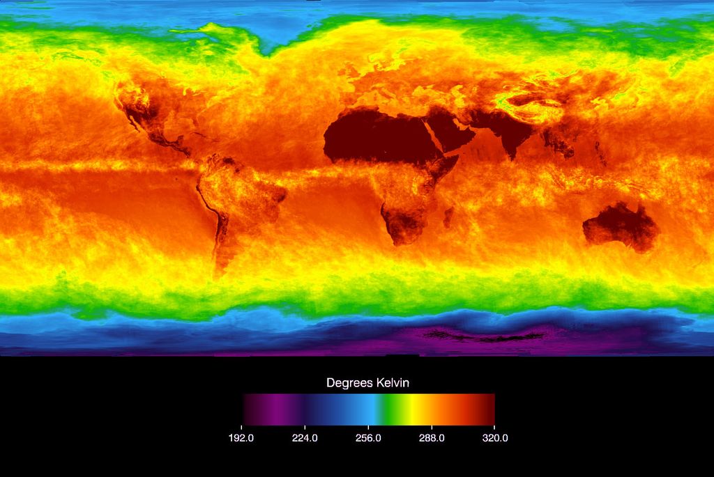
These two changes, cooling and warming from different phenomena, are lumped together under the term “CRE”, which stands for the Cloud Radiative Effect. As mentioned above, it has a shortwave (SW) and a longwave (LW) component, and when added together these give us the “Net CRE”. Planetwide, as is generally known, the net CRE averages out to a surface cooling effect of about -20 watts per square metre (W/m2). That is to say, clouds cool the surface more than they warm it. Here’s how that plays out around the planet.

Figure 1. Net cloud radiative effect (LW warming minus SW cooling)
Note the strong cooling along the Inter-Tropical Convergence Zone (ITCZ) above the Equator, and in the Pacific Warm Pool north of Australia. There, the clouds are cooling things by up to sixty watts per square metre (W/m2). As a comparison, a doubling of CO2 is said to increase warming by 3.5 W/m2, an order of magnitude less …
And here’s the same image, but from the Atlantic side:

Figure 2. As in Figure 1, Atlantic side. Net cloud radiative effect (LW warming minus SW cooling)
As you can see, clouds have a net cooling effect everywhere except over some deserts and at the poles. At the poles, clouds actually warm the surface. And on average, the cooling is much greater over the oceans (-25 W/m2) than over the land (-8 W/m2).
In short, the clouds are cooling the hot tropics and warming the cold poles, just as my theory predicts.
The real question, however, is not the static condition. It’s what happens as the planet warms. For that, I calculated the changes in the net CRE with respect to surface temperature for each 1° latitude x 1° longitude gridcell. Here are those results, again seen from both the Pacific and the Atlantic sides.

Figure 3. Change in net cloud radiative effect (LW warming minus SW cooling) per one degree C of surface warming. Negative values indicate that there is greater cloud cooling with increasing surface temperature.
And here is the Atlantic view.

Figure 4. As in Figure 3, but an Atlantic view. Change in net cloud radiative effect (LW warming minus SW cooling) per one degree C of surface warming. Negative values indicate that there is greater cloud cooling with increasing surface temperature.
Now, this is a most interesting result. As predicted by my theory that clouds are a major part of the thermoregulatory system keeping the planet from overheating, we find that almost everywhere on earth, as surface temperature increases, cloud cooling also increases (negative values). This is true in both hemispheres, in the tropics, on land, on the ocean, and in both the Arctic and the Antarctic. Only in isolated patches of the ocean does cloud cooling decrease with increasing surface temperature.
I’m currently in the process of writing up my theory that emergent phenomena act to keep the surface temperature within narrow bounds, for submission to some as-yet-undecided scientific journal. This analysis is most definitely evidence in support of that theory, so I’m glad I did this particular piece of work. But man, I hate writing for the journals. I always feel like I need to give myself a lobotomy to write in the thick turgid long-paragraph style that they like. Plus with the small word limits and only a given number of graphics, I feel like I’m fighting with my hands tied.
Ah, well, it’s just another part of life’s rich pageant, and I learned an important lesson in my 17 years living on small South Pacific islands—the universe truly doesn’t give a shift what I want to happen next.
So I’ll just have to keep on keeping on …
Tonight we have rain here in a dry year, so life is good. I got my second vaccine shot two days ago. Other than a sore arm and one day of feeling like I was hastily assembled out of random spare parts, not much in the way of side-effects. People have asked me why I got the vaccine … I say everyone has to decide for themselves the balance between their known COVID risk and the unknown vaccine risk.
Me, I’m 74, and if I didn’t do myself serious genetic damage in the ’60s and ’70s, it certainly wasn’t for lack of trying. Add in the odd co-morbidity or two, not unusual in a man of my late youth. Then there’s the fact that my gorgeous ex-fiancee is a front-line health worker, a family nurse practitioner who is exposed because she administers COVID vaccine shots and gives sports physicals at the local college. (And, I might add, she also did the same before she got vaccinated last month. Big props to her, and to all of the worlds’ medical personnel putting their lives on the line to fight the pandemic.)

Finally, and to our immense delight, our un-vaccinated daughter, son-in-law, and 19-month-old granddaughter are now all living together with us in our big old rambling house in the forest that I built with my own hands …
So getting the vaccine was an easy choice for me … but I don’t fault anyone for whatever they might choose.
Best regards to all, stay healthy,
w.
As Usual: When you comment, I ask that you quote the exact words you are discussing, so we can all be clear as to both what and who you are responding to.
Technical Notes: I’m using the “surf_cre_net_tot” (surface CRE net total) file from the CERES EBAF (Energy Balanced And Filled) dataset for the CRE data. For the surface temperature, I’ve converted the “surf_lw_up_all” (surface longwave up all conditions) CERES file to temperatures using the Stefan-Boltzmann equation. This gives surface temperatures that are slightly different from the Berkeley Earth gridded surface temperature dataset … which in turn is slightly different from the HadCRUT gridded surface temperature dataset … which in turn is slightly different from the GISS LOTI gridded surface temperature dataset … they’re all four close, but which one is right? Nobody knows, so I use the CERES data. It has the huge advantage of agreeing in every gridcell with the energy flows given in the other CERES datasets, including of course the surf_cre_net_tot dataset I used in this analysis.
Wavy jet stream tracks increase the length of the lines of air mass mixing and so produce more clouds which reduces solar energy into the oceans for a cooling world.
Wavy tracks appear to be related to levels of solar activity.
Over time, cloudiness changes affect the balance between El Nino and La Nina events.
We can see that during the recent warming spell there were less clouds, more El Ninos and a more active sun.
If the current solar quietness continues I expect to see more persistent La Ninas and a cooling world with the next PDO related temperature step being downwards after a series of upward steps during the 20th Century.
That said, Willis’s general theory is correct in that deviations from the temperature set by insolation, atmospheric mass and gravity are indeed prevented by local and regional cloudiness variations but one must distinguish between top down solar induced cloudiness changes that alter global albedo and the bottom up surface temperature changes that help to stabilise the system via convective adjustments. In fact the tropical cloud response is actually a visible proxy for those convective adjustments occurring in the tropics.
The top temperature for the ocean surfaces is actually set by the weight of atmospheric mass bearing down on the water surface because that in turn affects the amount of energy required for evaporation to take place. The heavier the atmosphere at the surface the more energy is required by the phase change since the pressure from above increases the strength of the bonds between water molecules by forcing them closer together. A heavier atmosphere therefore requires a higher water surface temperature to enable a given amount of evaporation.
You need to account for the emergent property known as wind as well in regards to evaporation and wind itself is affected by atmospheric density.
I hope Willis’ theory of emergent properties regulating the climate system includes wind as well. For instance, on a calm night anywhere on Earth a temperature inversion occurs where the air near the surface is cooler than that above it. This is due to thermal conduction between the atmosphere and surface, where heat is conducted from the gas to the surface where it radiates out to space (direct observation that refutes the GHG back radiation hypothesis). When wind remains in the boundary layer at night a temperature inversion does not form. The wind is increasing the amount of heat that is transferred back to the surface via conduction by mixing heat from aloft back down to the air at the surface.
Yes, convection also involves wind.
Willis Eschenbach:
“And during a clear winter night, a cloud comes over and we immediately feel warmer.”
Stephen Wilde:
“The heavier the atmosphere at the surface the more energy is required by the phase change”
The reason it feels warmer under a cloud is that the cloud is emitting huge amounts of latent heat released by the condensing water vapor. It is not due to the cloud reflecting LW radiation from the surface. Water vapor is a colorless gas and is present in the clear sky – which as Willis indirectly states, does not make us feel warmer – despite presumably reflecting LW radiation from the surface! A visible cloud is visible because it is made up of water droplets that are condensing from the water vapor. The phase change during condensation is what releases the latent heat which makes it feel warmer below the cloud.
Look at a picture of a cloud using infrared photography – the clouds are bright white because of the heat they emit – even when the cloud is not white in a visible light spectrum photograph. In an infrared photograph, the top, side and bottom of a cloud are all bright white as the cloud is emitting latent heat in all directions. If the cloud was warming the surface due to reflecting LW radiation from the surface, only the bottom of the clouds would be emitting heat. That is empirical proof that the cloud warming effect is due to latent heat of condensation, not due to reflecting LW radiation back to the surface. It is phase change latent heat being felt on the surface, not the ‘greenhouse effect’.
The cloud has a temperature fixed by its position on the lapse rate slope because that slope determines the height at which condensation will occur. When it releases the latent heat of vaporisation that additional heat results in further uplift which converts excess KE (heat) to PE (not heat). Therefore there is no warming effect at the ground.
However, in so far as the release of latent heat raises the temperature above that determined by the lapse rate then the whole vertical column from surface to cloud will become warmer.
If the cloud is 2C warmer than the lapse rate slope the the surface will also become 2C warmer than the lapse rate slope.
But I don’t see how this is at all relevant to my quoted comment above.
Stephen Wilde:
“If the cloud is 2C warmer than the lapse rate slope the the surface will also become 2C warmer than the lapse rate slope.”
Is there any other way that a cloud can be 2C warmer than the lapse rate other than from latent heat? In other words, the latent heat of condensation warms the cloud compared to the surrounding air, which warms the area below it (or at least slows its cooling).
“But I don’t see how this is at all relevant to my quoted comment above.”
You described how the atmosphere becomes charged with latent heat … I completed the loop and described how it discharges that energy … making the point that it is the latent heat that causes the area under a cloud to feel warmer, not the ‘greenhouse effect’.
Clouds are even better than CO2 at re-radiating infrared energy. The heat of condensation, occurs at the cloud level and has very little effect on surface temperature, unless the cloud is on the surface (i.e. fog).
It seem obvious to me that cloud would be a negative feedback. Imagine if it were always cloudy everywhere all the time. Would it be hotter or cooler at the surface? Cooler obviously.
Excellent analysis Willis! It should be published.
Correct!
H₂O is radiation interactive in all three of it’s physical states; gaseous, liquid and solid.
Gaseous CO₂ is minimally interactive with a few weak infrared frequencies.
Willis’ analysis above considers clouds in their passive interactive form, reflecting higher energy wavelengths from a cloud’s top surface and slowing infrared radiation leaving Earth underneath the cloud.
Clouds also interact directly, as Willis has well described before. Convection, condensation, even evaporation are where clouds actively interact with Earth’s atmosphere.
Admittedly, where CERES is involved, it is difficult to explicitly identify passive versus active cloud radiation involvement. Except perhaps where specific cloud formations are separated.
Willis clearly proves cloud temperature controls reduce Earth’s surface temperatures and establish maximum temperatures for Earth’s surface.
Cloud feedback is negative.
Ah, no.
If want you claim is true, then why no links to examples?
Where a human’s IR color photography is towards orange at 95°F, a cloud that is white on the same film is certainly not hotter than 100°F.
That white does not represent temperature, but sheer volume of water droplets radiating infrared radiation.
It’s like photographing a white sheet in full sunlight.
Stephen, what proportion of heat transfer from the surface to the top of the troposphere is due to convective forces (including latent heat from evaporation) verses radiative. This is not easy data to find.
It depends on atmospheric composition. For a completely transparent atmosphere then convection would be all of it and just sufficient to balance the upward pressure gradient force with the downward force of gravity.
As one increases radiative opacity then the share involving radiation would increase and the share involving convection would decrease. If the atmosphere became 100% effective at absorbing all energy coming from space then it would be behaving as a solid with zero convection so that is never going to happen with a gas.
Thks for the reply. I have tried to find an actual percentage of surface heat transferred by convective forces. I would think with radiative gases making up a few percent of atmospheric gases (water vapor dominating) that convective flows would make up 90%+ of heat transfer (WAG). If so, offsetting 3 wm^2 from a doubling of CO2 would be a trivial change in convective forces
Stephen, “The heavier the atmosphere at the surface the more energy is required by the phase change since the pressure from above increases the strength of the bonds between water molecules by forcing them closer together.”
Water doesn’t compress much. A heavier atmosphere increases the boiling point of water, because water does not boil until its vapor pressure equals atmospheric pressure. Higher atmospheric pressure = higher boiling temperature means rate and amount of evaporation is suppressed over the same temperature range as imposed by the lower atmospheric pressure.
Here’s an illustration of the boiling point of water on the moom, Mars, and Venus. On Venus, water boils at 282 C.
The terrestrial rate of evaporation over the range of 0-100 C is suppressed on Venus because the vapor pressure of water at 100 C on Venus is far below the atmospheric pressure.
Poor wording on my part. The pressure adds to the amount of energy required to break the bonds and your description is better.
Stephen, I’ve asked this before without success, but I’m a patient man.
What are the units used to measure the “waviness” of the jet stream? Science is all about measurements. How can we know if the jet stream is “wavier” without measuring it?
Regards,
w.
Nobody has ever tried to measure it. I wish they would.
There are plenty who agree that it does vary and the historical charts that I have seen do confirm it. The most extreme waviness was during the Little Ice Age with lots of ships logs available indicating that mid latitude depressions and their frontal zones then ran nearer the equator than they do currently.
Steven, if you agree that nobody’s measured it, how do we know it was “extremely wavy” during the LIA? I mean, AFAIK you can get cold fronts without jet steam waviness.
w.
The old charts and records show that during the LIA the mid latitude depressions much more commonly entered the Bay of Biscay during the winter whilst still passing to the north of Scotland in summer. During the recent warming spell such depressions rarely went that far south.
In the Mediaeval Warm Period the most frequent depression tracks were even further north such that the Isles of Scotland were pretty equable, with more agriculture and greater populations than today and a lot of easy interisland travel.
We do know that global cloudiness decreased during the 1980s and 90s which coincided with reduced meridionality in the jet stream tracks around the world.
Finally, I would just mention that despite my agreeing with your basic thermostat hypothesis I have never tried to cast doubt on it by asking you to quantify, precisely, the variations in convective activity that you have observed.
If it helps, I have been putting together a series of charts, taken at the same time each year, showing both upper atmosphere (500hpa level) and surface level isobars. The intention is to record and assess whether there is any identifiable long term change, both year to year and over the decades.
Obviously changes of this nature do occur and we can see that temperatures in the late 1800’s were – on the basis of the chart data – significantly cooler than today and the resulting tracks of the cyclonic depressions very much further south with the noted results.
The charts are the product of the European weather service, older ones obviously being ‘Reanalysis’ of available data but they do give a useable visual assessment of general trends.
Historical Charts – How the Atmosphere Works (wordpress.com)
Thanks. good work.
Willis,
“FAIK you can get cold fronts without jet steam waviness”
Jet streams correlate with cold fronts and jets are strongest above the largest horizontal surface temperature gradient.
Null Earth Surface Temperature
Null Earth Winds at 250 mbar
BTW Notice the good example of a westerly flowing Arctic Jet north of the coast of Siberia.
I have been doing weather forecasting and research for over 40 years now. And this entails regular analysis of all the charts. I still do contract work. This is only my anecdotal feeling, which is shared by other forecasters, but I have noticed in about the past 15 years that the jet stream and 500 mb patterns seem to be more chaotic than they used to be. I would not say more “wavy|”, but not as smoothly defined as I remember. This makes for a lot more difficult forecasting. I did not do forecasting before the 80s so I can’t say what they were like back then.
Thanks.
My experience goes back to the late 1950s. There was more chaotic behaviour back then but it smoothed out in the late 70’s to late 90’s and I’ve been saying for over 10 years that I noticed increasingly chaotic behaviour since 2000 which has since become more pronounced. Those three stages coincided with cooling, then warming and now cooling again.
I remember our forecasting last summer for western Canada and analyzing some really wacky 500 mb patterns. One fellow commented, “whatever happened to the regular Gulf of Alaska trough and the upper ridge over western Canada?”.
Cycles.
May it be a question of the speed ? Slower =”wavier” ?
Could it not be measured by determining the overall length of the tropospheric jet stream? Longer means wavy, shorter means more circular. Data from airlines might do it. Or perhaps there is some satellite way of measuring wind speed.
The problem with measuring these things is that you first have to build bins of cloud type just to start.
I had a discussion with a scientist about this and the point that came out is that clouds can heat or cool the world.
The drivers, or a few are, time of day, time of year, latitude cloud altitude just to name but a few.
We also know from the work of Willis that a change of 1% in gross cloud cover can move the climate from warming to cooling, just not sure which way without knowing exactly the radiative balance.
Please write the paper up, I don’t hold much hope that it will alter the religion.
It may lead to more proper brains applying rigor to the field.
I would like to suggest the waviness of the polar jet streams should be measured in terms of the curvature and torsion of the midpoint of a bundle of velocity vectors plotted on a polar coordinate system. The surface of the base coordinates is a plane tangent to the earth’s surface at the intercept of the axis of rotation of the earth.The plane may be translated parallel to the axis of rotation to align it with a given pressure altitude. Note that there is no requirement for the pressure altitude to remain at a constant altitude above the ground level at the axis of earth’s rotation.
So how to measure the curvature and torsion of the wind vectors within the pressure level? Certainly mapping general airline aircraft GPS motion would give local information on the necessary vectors. The delta between GPS altitude and pressure altitude gives a delta z, while GPS x,y coordinates allow computation of the necessary components for the two curviness components. Additionally, weather balloons can provide data more suitable for mapping the entire curve by floating at defined pressure level together with GPS information somewhat analogous to the Argo floats. This is using first order derivatives of the flow vectors to determine waviness elements.
Conceptually the idea works, however the chaotic nature of winds and the ability of airflows to quickly change direction, the assumption of function continuity for the mapping can lead to problems. The solution of these boundary value problems is, as they say, an exercise left to the reader.
A physical quantity should be independent of a coordinate system.
Hmm, there are a number of interesting physical quantities handled via tensors. Tensors are the descriptions on how these elements transform between different coordinate systems. So to what physical quantity are you implying that is varying as a function of coordinate system?
If that’s your big rambling house, Willis, I’d sign for one. And sea-level-rise-proof too!
Actually, that was a photo before I added on another bathroom, kitchen, pantry, and a lovely little art studio for my good lady …
w.
Mr. Eschenbach,
Thank you for this work. You have the patience of Job.
A third way they affect thermodynamics in the atmosphere – they provide a surface for gas to conduct heat to which is then radiated to space at a higher rate than the gas is able to radiate it. Temperature inversions form above cloud layers just like at the surface at night, which is yet more proof that the back radiation “greenhouse gas” hypothesis is erroneous.
I suspect that the net change in CRE is due to weather patterns that occur in those regions and the types of clouds associated with those patterns.
“We can actually physically perceive both of these effects. During a clear summer day, a cloud comes over and instantly cools us down. And during a clear winter night, a cloud comes over and we immediately feel warmer.”
Absolutely regarding #1. On a breezy partly cloudy day, alternate sunshine and shadow results in dramatic warming and cooling. But #2? Dunno, maybe I don’t get out at night enough, but if I’m outside on a partly cloudy night I doubt very seriously that I would immediately feel warmer if a cloud came over.
Regarding, “…will clouds exacerbate the warming or will they act to reduce the warming?” Well reflection of the sun’s rays seems to be a primary effect, that is to say, clouds prevent some of the heat from the sun to never reach the surface. Retaining heat from the surface day or night is secondary. After all, it can only retain a portion of the heat the absence of clouds allowed in in the first place.
Thanks for the IPCC link I’ve added it to my file of factoids and suchlike.
I have spent thousands of nights outside all night during my plant nursery days in West Central Florida.
I do not know about feeling warmer, but I can tell you for certain, having measured the change on hundreds of seperate occasions, that when clouds stream overhead on a cold night undergoing radiational cooling, the temperature of the air as measured by thermometers jumps up several degrees in minutes, where without the clouds it had been dropping steadily and often rapidly to the dew point and sometimes below the dew point slightly.
This is true for even a tiny wisp of high jet stream cirrus.
Everyone doing agriculture in Florida has had entire crops saved by a streak of thin high clouds that prevented or lessened hard freezes.
And if that is not enough, there were many occasions that the cloud streak was temporary, and when it passed or moved south or north of our location, the temp quickly resumed downwards.
I am not talking about a sometimes or a small effect, but every single time, several to five or more degrees in minutes.
This is a factual first had account, and the effect can be observed in real time whenever those conditions exist.
I have always said that it is obvious that many of the warmistas have never spent any time outside.
Spending entire nights outside with your livlihood on the line, with thermometers all over the property, while studying subjects such as meteorology and climatology and indisciplinary natural science at the nearby University…or even just doing it cause you like to stay up all night walking around outside…will teach an observant person many things that cannot possibly be gleaned without this experience.
So your intuition is on point Steve. There are things we can only truly know deep down and for sure when we have direct personal experience.
And believe me, I have wondered long and hard exactly where the energy for this jump in temps came from.
Most of this experience was in the mid 1980s to early to mid 1990s, so it predates all of the many discussions and such about radiative gasses in the context of global warming alarmism.
”I have wondered long and hard exactly where the energy for this jump in temps came from.”
The heat comes from the ground.
No, not it these instances.Heat flow from the ground to the air is not even close to fast enough to warm air 5 to 6 off the ground by several degrees.
Heat flow from the ground is not even fast enough for 70° soil to prevent frost from forming at 38° of air temp.
Subsurface heat does not warm air by any appreciable amount.
Think of the opposite situation…a hot sunny day on a beach. The top few inches of sand are scorching hot by early aftrrnoon, but a few inches below that the sand is cool, and even cold if it is early in the year, such as New Jersey on a warm Memorial Day weekend.
Soil is a very poor conductor of heat.
In Florida the sandy soil is an even worse conductor than more typical soils with a high organics content.
Oh, one more thing…these clouds originate in the tropical Pacific, and streak from the southwest to northeast behind cold fronts in that part of the country.
They are far more common when the Pacific is in a particular state re ENSO…I will leave it anyone interested to guess which state leads to these types of clouds occurring with regularity.
Like I said, maybe I don’t get outside at night enough and certainly not with my eyes glued to a thermometer (-:
The stories I have from those days…
Things very few people know anything about, like what are called “frost pockets”…places that on cold nights (and only cold nights, that is when there is radiational cooling) are routinely as much as tens of degrees colder than surrounding areas; preventing freeze or frost damage to sensitive crops with a layer of ice; how a dust devil or a hail storm can wipe out a grower in literally minutes, while a (or a few) hundred feet in any direction nothing at all happened; how fast a single cow that jumps a fence can eat an entire vegetable garden without making a sound, and do so faster than can be believed; how a person can literally levitate and run across the top of knee deep swamp when a alligator creeps up behind you…
We had a neighbor who was a strawberry grower, who lost everything one night because he and his wife went to a movie.
In two hours a front moved through and temps dropped so much so fast that by the time he got home, his valves were frozen and he could not turn on his water .
He said he knew when he walked out of the theatre and smelled the air that he was ruined. He had been one of the wealthiest people in Pasco county at the time…
“1983
In cold pockets (what locals in Pasco county called “Frost Hollows:
Weather Facts: Frost hollow | weatheronline.co.uk), there were many more freezes than this list shows. We had freezes every Winter back then, with one as late as April.
The night/day of the space shuttle disaster, it was 17°F that morning at our place:
Timeline of Major Florida Freezes – Florida Citrus Mutual (flcitrusmutual.com)
Nicholas,
Can you kindly supply some more weather details?
I assume that your observations were made in Pasco County.
Roughly how far inland from the gulf coast?
I assume that these streaming clouds were mostly cirrus?
If so, did they show evidence of descending ice crystal virga below them?
Did the effect only occur with the clouds directly overhead or to the side?
Was there evidence of a front, in particular did the cloud line descend to the west or were they in a horizontal layer?
Any estimate on how high up the clouds were?
Regards,.
Philip
The effect is also noticeable in the high desert – esp. when the clouds leave and the temp drops several degrees.
I would say absolutely for #2 as well. In SoCal, cloudy nights are warmer than clear nights.
The explanation is that clouds moving in overhead are associated with warmer air moving in overhead at whatever level that cloud occurs. It will suppress radiative cooling by radiating down but will never actually raise the surface temperature above the point that it would have been in the absence of radiative cooling.
The suppression of radiative cooling at the surface allows conducted energy from below to reach the surface without being lost to space which is what bounces the surface temperature up again a few degrees.
Under a clear sky the surface temperature is derived from the balance of energy between that flowing up from beneath to the surface and that flowing from the surface to space.
That is why you get more radiative cooling over snow. The snow cover suppresses warming from beneath by acting as an insulator.
One might ask why very cold cirrus cloud can have such an effect when it is at a height far colder than the surface. The reason is that the downward radiation reduces cooling of the entire vertical column and so follows the lapse rate down. If the high cloud is say 2 degrees warmer that the clear air that was previously in place then it knocks 2 degrees off the cooling effect at the surface.
Note that the downward radiation warms nothing, it just reduces the rate of cooling all the way down between surface and cloud base.
You are not speaking from experience, that is for sure.
I know you know physics, but intuition and what should be true are no help in specific situations, and this is one of those situations.
What I have seen many many times is not what you describe.
There is no time for what you are talking about to cause the temp rise that occurs.
It is something else, like perhaps reflected heat from warmer areas that may be hundreds of miles away (maybe, IDK for sure…I only know for sure what I and many others have seen and continue to see every single time this occurs), but photons move fast.
Now where there is water is another story.
Frost will not form near water very readily, and near a large body of water like an ocean, it may be nearly impossible to get frost.
Key West has never had frost, although the temp and dew point have at times been low enough to cause frost to form.
Growers in Florida have sought out large bodies of water such as lakes or east/west stretches of rivers such as the Withlacootchee or the Caloosahatchee, for over 100 years, and planted preferentially on the south sides of them, although any grove or field next to water will be protected by many degrees compared to nearby areas.
It is very surpising that ice crystal clouds many miles up in the atmosphere, which are certainly many tens of degrees below zero, can have an effect of causing warming to occur at the surface, where it is far warmer (or less chilly in the cases in question here). Obviously (or seemingly obviously at least) it is not any sort of direct transfer of energy from the clouds to the ground, and there has to be more to it than just blocking the flow of energy from the surface and more particularly from the air just above the surface (I have not measured the temp of the ground surface in these cases, but I will next time. I had no devices like laser thermometers back in the day, or a infrared camera either).Back when I was observing this to occur with some frequency, there was no internet and few people even had a PC, and in any case there were no websites for weather services. It was never exactly frequent, I wish it had been. The first time I saw this, it was not clear what had caused the reversal in the trend lower. But eventually I/we had seen it happen many times, and on at least one occasion more recently, a predicted freeze was occurring and was reversed over a large part of the state when cirrus clouds moved in. I was looking for the news story in a newspaper archive but have so far not found it.
Eventually we knew well that those streaks of clouds most would ignore on a satellite picture could and would have a warming effect. And it did/does have the effect, every single time.
Heat flow from the ground is astoundingly slow.
As an example, I have seen and it is demonstrably true that in the month of October, in Florida, when the temperature was over 85° during the day every single day for the previous 6 months if not more, a cold front goes through and drops the dew point to a very low value, and then after sunset the wind dies down to calm. The temperature drops rapidly to the dew point, and within hours of sunset, there is frost on every blade of grass for tens and tens of miles (It always forms first on the roofs of cars,BTW). The ground is obviously very warm beneath the surface, but that matters not at all for the formation of frost. Only the wind, and the dewpoint, and the lack of clouds. Then some high clouds streak overhead, and the temp warms from, for example, 28° to 34°, or from 34 to 39°, and seemingly as fast as you can walk over and look at some thermometers placed at eye level all around the farm, and with frost still all over the ground.
I have never seen that the soil temperature has any effect on frost formation. The ground in peninsular Florida is never very cold, and often very warm, and the frost and the falling temps simply do not care.
Due to the speed of photons any warming effect down along the lapse rate slope is immediate so you get the air temperature increase straight away. It then takes time to raise the surface temperature, as you say.
If the change takes the temperature above freezing point then you don’t need to wait for energy to come up from below because the warmer air will work on it in the meantime. I have often seen ground frost persist until the air temperature gets up to about 39F if the sky is clear but lower if the cloud cover is thicker.
So, your streak of high clouds will warm the air to the extent you say due to the effect travelling down the lapse rate slope but because the clouds are high or thin there will still be enough radiative cooling to offset both the warmer air and any heat coming up from below for a longer period than for thicker or lower cloud
It is a balance of multiple energy flows.
You could get ground frost persisting even with an air temperature of 39F.
I do not recall ever seeing frost melt prior to sunrise…personally.
I have routinely prevented frost damage to by bananas by waiting until sunrise and then turning on the sprinklers to melt it.
It takes a lot of energy to melt ice, and when it melts is when the plant damage occurs.
There can be frost of the leaves of sensitive plants all night, and as long as it does not melt by itself, there will be no damage, but if it is allowed to melt from the Sun hitting it or the air warming it, the leaves will be destroyed.
Farmers that protect crops with water to form a layer of ice know well that you have the leave the water on until all ice has melted, to prevent damage.
If one, for example, turns of the water in the morning after the temp has risen above any temp that can cause damage, but before the ice has completely melted, then the plants are destroyed. The melting ice absorbs a huge amount of energy, as anyone who has studied physics knows.
And yet it still seems surprising:
It is not the frost forming or persisting that damages…it is when it melts.
Melting it off with water prevents the latent heat to melt the ice crystals from being taken from the plant tissue.
Here is another thing I had not made clear perhaps: Often these streaks of cirrus clouds are very narrow. You can look up at the sky and see that it is clear to the south and to the north, then look at the satellite shot on the news and see how narrow in extent it sometimes is.
But it does not matter to the effect.
I do not exactly know what you are saying when you talk about “due to the effect travelling down the lapse rate slope”.
I suppose one would have to send up a radiosonde balloon to know anything much about what is occurring between the thermometers and the clouds or the open sky.
If I say anything about where I think the energy is coming from, I am not going to assert I know for certain. I only know it happens fast. I cannot say if it is a few seconds or maybe five minutes, but I know it is very fast…seemingly immediately.
To know how fast, one would I think need to see the clouds coming and watch the thermometer and the sky and try to tell exactly when the leading edge of the cloud passed your ground location.
Those clouds move fast…hundreds of miles an hour, at least some of the time. Maybe all of the time, but when it is continuous it is hard to say.
When spotty or streaky, they appear suddenly.
At times I am fairly certain they went from over the Pacific, past Mexico, past the Gulf, to over Florida in under an hour or maybe a few hours.
Even though those high clouds might be narrow they still signify the arrival of a layer of warmer air up aloft.
If that warmer air is ,say, 2C warmer than the air it replaces then due to the speed of photons the entire vertical column from surface to cloud also becomes 2C warmer.
It might help this discussion if you would describe the “adiabatic lapse rate” under “normal, dry and humid” conditions and why such effects vary over surface type.
Funny that down dwelling IR doesn’t seem to melt snow, the snow in my neighborhood melts under direct sunlight but not in the shade. DWIR should be relatively evenly distributed. I would think that IR would melt snow faster than UV
I love it when people poke holes in sacred cows.
Also, why don’t solar panels work at night, as DWIR is what really warms the earth, not that shiny sunlight thing, which effect is far less?
Good question, rhoda. The answer is, a solar panel requires enough incoming energy to kick electrons free so they can generate a flow of electrons, which we call “electricity”. Thermal microwave doesn’t have the energy to do that. Solar energy does.
Or at least to date we’ve never been able to find a material where thermal microwave has enough energy to do that.
w.
”But #2? Dunno”
We have a thermometer on the front porch. Temp goes up at night when it clouds over.
Up a lot too, sometimes as much as 5C.
I’m not sure it’s back radiation though I guess that’s happening too. For me, most of the heat comes from the land heated during the day and clouds simply slow down the convection. Temp must go up.
Where I live, winter tends to be cloudless and dry. I am always happy to see clouds on a winter night, as it portends a morning after without black frost. Always important for us mudgrub veggie-heads, the frost… and the drought…
HOWEVER
I find this true only for full, horison-to-horison clouds. Whereas I have ample opportunity to enjoy the fleeting pleasure of a small-to-medium cloud blocking the sun’s heat enough to work outside while it lasts, I must say, I have never looked up at one night time cloud and thought; “wow, that’s nice and cosy”. At 1614 meters above sea level, I feel close enough to the average cloud to have noticed?
Thus, sir, I respectfully state my doubts about radiative clouds, I always thought of them more as insulating, keeping the little heat we have in via reflection from below, rather than overpowering the cold by sending me heat. I even considered that they may simply disturb convection, keeping daytime air down near the ground? A type of inversion?
But then, you are the expert, so I’ll keep your theory at the back of my mind until proven wrong. Or right, of course.
Clouds consist of ice crystals which have a high emissivity, not to mention a relatively high emitting surface area.
Are they indeed always crystals?…any numbers on the IR reflectivity? Or at least the temperature I can expect from your average winter night airborne ice crystal? Plus, are these crystals aligned horisontally, so they can radiate at the ground? Just asking. For my plants…
One point to add to discussion, downwelling IR is refected at the surface and does not warm the ocean at depth…
Separate question, but see my post “Radiating The Ocean” for a full discussion of this question.
w.
Willis, from your link:
“Look, folks, there’s lot’s of good, valid scientific objections against the AGW claims, but the idea that DLR can’t heat the ocean is nonsense. Go buy an infrared lamp, put it over a pan of water, and see what happens. It only hurts the general skeptical arguments when people believe and espouse impossible things …”
Willis, if you can supply a link or an argument as to how CO2 absorbing and reradiating at 15µm acts as a greenhouse gas without comparing it to an IR lamp, that would be great (-:
Me? I think downwelling 15µm IR cancels out upwelling 15µm IR resulting the surface not cooling off as fast. But it does cause warming, and the warming comes from the sun, not from the downwelling 15µm IR from CO2. And the sun at over 5,000K, not a puny IR lamp, continues to warm the surface until equilibrium once again occurs.
So long as the pan itself isn’t heated, not much except evaporation
Try heating a plastic bath from above with an IR lamp, you won’t get far at all.
Irrespective, the temperature of CO2 radiation is very cold.
The only way it can even be measured is by creating a negative temperature gradient using a strongly cooled sensor.
The only way ocean heat can increase below 700m in 65 years is for net evaporation (evaporation less precipitation) rate to REDUCE.
I just lost James Hansen missing heat. It is physically impossible for heat to conduct down a 700m deep column and warm the mass to 2000m by the “observed”. 0.06C since 1955.
The only way to increase ocean heat content in that time is to reduce net evaporation rate. That is consistent with larger warm pools because warm pools have net precipitation.
The heat transfer down the water column is not by conduction. If it were, then you would be correct. But heat transfer down the water column is via turbulent mixing (called ‘diapycnal mixing’), not thermal conduction. Diapycnal mixing is counterbalanced by slow upwelling of very cold deep water, driven by the thermohaline cycle. The result is the ocean’s well known thermocline temperature profile. Anything which raises the average temperature of the ocean’s well-mixed surface layer will lead to a gradual warming of the thermocline. The process is relatively slow, but not nearly as slow as thermal conduction.
Carbon dioxide lasers are used to cut steel (and many other materials). What wavelength do you suppose is generated by a CO2 laser? Answer:about 10 microns…. corresponding to the peak emission from a very low blackbody temperature. But surely that 10 micron infrared laser easily cuts steel. Microwaves (corresponding to peak emission from extremely low blackbody temperatures.. see cosmic background radiation) can heat food in an oven, and easily burn skin… the army has a microwave based crowd control weapon which can burn skin from hundreds of meters away. You seem confused about how radiation transfers energy; radiation does not have a ‘temperature’.
Especially if you’re referring to the 15µm IR downwelling from CO2. A black body that radiates predominately at around 15µm would be a block of dry ice.
AFAIK, a black body emits more intensely at all wavelengths than another body with a lower temperature, notwithstanding one of those wavelengths is the peak emission of the cooler body.
And if those two bodies are radiating toward each other, Does the peak emission of the cooler body warm the other or just cause it to cool off slower?
The cooler body blocks some of the warmer body’s view of -270 C outer space is the best way to understand it.
Yep! There’s a nice little thought experiment with various temperatures of the cooler body from cryogenic temperatures to becoming as warm as and then finally the warmer body.
Cool off slower. So the next day the earth is a little warmer when the sun comes out and begins heating it up again, but from a slightly warmer starting temperature so the final temperature of the day is slightly warmer. Don’t get me wrong, as I’m the first to say that there is no impending climate crisis, but the greenhouse effect from CO2 is real. Real but small. The S-B T^4 causes radiation to increase dramatically as temps increase, limiting the high temperature. That’s why the global average temperature can’t go up very much from even a large increase in CO2 reradiating LWIR.
I’m curious to know how, while the atmosphere is not a black body and 0.04% of the atmosphere is not a black body and the spectral lines of CO2 are well known, Stefan-Boltzmann is applicable to this question.
The question is not whether CO2 absorbs IR; we know it does. It’s a matter of whether the net result of conduction, convection, advection and water phase change and variability in heat capacity of the atmosphere is a delayed cooling of the surface.
I didn’t say the atmosphere is a blackbody. It isn’t. I was referring to the surface temperature when I said earth. I assumed that would be obvious to everyone, but apparently not. By the way, I taught Thermodynamics at a major University for years.
Yup, exactly right. The effect is a reduction in cooling rate, not a warming. Take an infrared thermometer and point it at a clear portion of the sky…. it will read a very low temperature. Then point it at a cloud… it will read many degrees warmer. In both cases (cloud and clear sky) the temperature is lower than ambient at the ground…. but clear sky cools the ground by radiative loss more quickly than clouds do.
The warming can only go from hotter to colder, of course.
As to whether the warm body cools more slowly than in the absence of the cool body, it’s less clear.
A cloud can soak up a lot of energy without changing temperature, and there’s no vacuum between Earth and the cloud. There’s more than radiation going on.
“As to whether the warm body cools more slowly than in the absence of the cool body, it’s less clear.”
No it’s perfectly clear: that is exactly what happens.
” It’s a matter of whether the net result of conduction, convection, advection and water phase change and variability in heat capacity of the atmosphere is a delayed cooling of the surface.”
The net is an average 16C, so yes.
https://www.space.com/17816-earth-temperature.html
Almost everything solid/liquid, including water, absorbs IR. Almost nothing “reflects” it, except polished gold (hence the coating on the James Webb infrared telescope mirror).
The point is all downwelling IR is captured at the surface and thermalized. Then convection, IR upward radiation, or mixing happens.
“they’re all four close, but which one is right? Nobody knows,”
One of my favorite adages is, ‘A man with a watch always knows what time it is. A man with two watches is never quite certain.’
I always said, why bother to carry around a watch, when one can always just ask someone else who is lugging one of those fragile and expensive things around all the time.
Funny.
When I as working construction, a carpenter asked an electrician, my journeyman at the time, what time it was. The electrician told him: “Time to buy a watch”. The carpenter asked again, and the reply was the same. He never told the carpenter the time.
A different perspective.
The electrician was in his 60s, and apparently had, for 40 years, been asked the time by those who refused to lug around those “fragile and expensive things”, although they are neither fragile nor expensive. I still have the same Seiko watch my wife bought me some 47 years ago, wore it while I worked as an electrician, taking it off and sticking it in my pocket whenever I had to work things “hot”. Scrapped up, replaced the crystal multiple times, but it still works and I still wear it when out and about, even though I have a phone/clock, habit.
Nothing against you Nick. Even after this bit of apprentice training, I usually told the time when asked, but there were times when I, like my then retired and deceased JW, would answer the same as he. I had a job to do and keeping the time for others was not part of that job. And it is not a common courtesy to provide that information when negligence is the reason for the asking.
Drake
Hey, Sparky!
You got prejudice against wood boitchers?
As a carpenter I always took off my watch at start of workday and left it in the truck to save it from being destroyed! I’d be worried about a rude sub contractor finding nails in his Romex or piping, but that’s just me. Once electronic leashes (pagers) were developed most workers have their own time piece available at hand!
Any Moe can be a carpenter, it takes an electrician to really Curly you.
If one who proudly displays his time piece and doesn’t want to share the time just ask if it’s 25 or 6 to 4 (with a little rhythm)!
To be absolutely certain, you should have no watch.
Why worry about what time it is? You can’t change it or do anything about it.
Does anybody really know what time it is? ….. https://genius.com/Chicago-does-anybody-really-know-what-time-it-is-lyrics
A very interesting exercise. The side look is how temperature effects the water vapor in the atmosphere which of course effects cloud cover. Additionally one has to consider the inertia from drought and rainy conditions over land (dry conditions perpetuate dry conditions, wet perpetuate wet unless something happens to feed in dry or wet air from elsewhere).
Then you can get to where the atmosphere is so warm as you go up no clouds will form. We have that a lot in the Southeast US in the hot months where we have days where it is very hot, hazy and cloudless. A lot of variables around cloud formation. A sticky wicket as they say.
I have pondered that thought many occasions. Never have I seen it discussed.
Land holds negligible heat so its role in climate is limited. Weather occurs over land. And weather is important for habitation but the energy that sustains the climate system is almost all stored in and released from the oceans. The atmosphere plays a role in regulating the heat input to the ocean surface and driving ocean currents that transfer heat poleward from the tropics.
I’m trying to construct myself a Solar Power Datalogger
You’d have thought = fairly simple.
viz: take a small solar cell panel. Because solar cells are ‘current sources’ you connect a resistor across it to convert the current to voltage and then record the voltage
Easy peasy and inexpensive – big thanks to Lascar for the EL3 data logger
But then, to calibrate the thing
So, get a proper solar power meter (SPM) (
One that not already a logger – not easy to find apart maybe in the proper Weather Station kits. Hideous expensive
Then the fun starts because it is obvious that the solar cell and the SPM don’t see the same sky. SOMETIMES.
Never mind for now
Just a few days ago it was cloudy here at lunchtime:
Get your round head around those numbers then: explain how clouds cause Positive Feedback heating.
Even worse, they simply can not ‘force’ the surface or in fact anywhere in the atmosphere below them.
Lapse Rate says that the cloud, whatever height is it at, is always colder than everything everywhere below it and Entropy says that cold things do not warm warmer things.
Next:
The tops of clouds, in fact ALL parts of clouds, are dazzling white.
Always.
Grey clouds are an optical illusion
Clouds thus have epic high Albedo
But also, they are made of (droplets of) liquid water and thus have very high emissivity, easily 0.99
And where they emit (upwards) from is at the very base of the Stratosphere
(Perhaps remind now that CO2 has perfectly Zero Emissivity)
The Stratosphere being noted not only for its Stratification but also that is is very very dry.
There is no water there and thus, is nearly transparent to the Infra-Red Radiations coming off the tops of the clouds.
Poor hapless old Climate is thus dealt a humongous Double Whammy by the tops of clouds….
Q. Why did the Polar Vortex come pouring down the Great Plains corn belt and dump on Texas and not land on the ocean(s) either side of North America?
A. Lapse Rate
Tillage/farming/corn growing has dried out the land, over huuuuge area.
The air above it was/is very dry so that air would have had a Lapse Rate of 10C per km
Compare to wet air with a Lapse Rate of 6C per km
Thus the thermal gradient above the Great Plains was very steep and whatever energy there was in the dirt/soil/landscape simply poured out, or down (always down) the thermal gradient as heat energy is want to do.
Thus the steeper Lapse Rate very effectively reduced the height of the Tropopause
So: The dry air above the Plains effectively opened the door and threw out the red-carpet Welcome Mat for the Stratosphere to come and pay a visit.
It obliged.
a bit OT…
If anyone is into graphs and correlations, an interesting one to go research is the per capita rate for heart attacks.
Which anecdotally corresponds with places where huuuuge amounts of Roundup are used?
And you thought Roundup caused cancer?!!?
The Great Plains use massive quantities of Roundup. That is why the plants are all dead, the dirt is so dry, the lapse rate is so high and why the stratosphere came calling.
Another place, also bizarrely where its been cold recently and has a high per capita heart attack rate and high Roundup use, is Florida.
Apart from being an Organophosphorus compound, very lovely I’m sure, Roundup is a chelator.
It locks up metals.
Like Zinc, Magnesium, Copper = things that might cause dementias, heart attacks, strokes and ‘co-morbidities’ if they run into short supply………..
funny old world innit
You may want to look at the high pressure ridge that formed over far western North America that directed the very cold polar air into Texas and why these highs form there in the winter. Might have to do more with ocean water temperatures and where mid ocean lows and highs form than lapse rates. What is happening in the Indian Ocean can directly effect what is happening over you head. It’s all interconnected.
“Tillage/farming/corn growing has dried out the land, over huuuuge area.”
It’s probably much more complicated than this. Those crops also shade the ground and reduce evaporative water loss by the ground so what rain does fall stays around longer. Evapotranspiration also increases the humidity directly above the crops. Higher CO2 decreases the water pulled from the ground by the crops. No till farming gets larger every year. Crops like hay and pasture lessen ground water loss from runoff. Crops really only impact the ground from May to Sept, about 5 months out of 12. Rain and snow during the rest of the year don’t see much “crop drying”.
I would *really* like to see how the climate models handle land use. My guess is that they don’t even try. It’s just part of their larger “tuning” parameters.
Have you ever stood in the sun then been shaded by a passing cloud? Did that produce heat or cooling?
With my deepest apologies to Joni Mitchell…
Both Sides Now
Woes and blows to warmist scares
Excise schemes now in cross hairs
And weather claxons now despair
I’ve looked at clouds that way
We all know that they block the sun
And rain and snow on everyone
So many things frauds would have done
But clouds got in their way
We’ve looked at clouds from both sides now
From cool and warm, and still somehow
Warmist delusions I recall
They really don’t know clouds at all
Loons and goons with feckless deals
Are busy advancing their ideal
And so their fairytale reveal
We’ve heard them yack away
But now it’s not supposed to snow
So we’re laughing as they eat crow
And polar bears, their numbers grow
Hint: check the Hudson bay
We’ve looked for signs of high tides now
From near and far, no rise somehow
Warmist delusions we recall
They really don’t know squat at all
Tears and fears and feeling proud
To say “It’s bullshit!” right out loud
Dreams and schemes of circus clowns
The crooks’ in disarray
This now transends just acting strange
We shake our heads, they’re so deranged
They’re data’s lost, still unexplained
United Nations way
We’ve heard their crap, their sacred cow
From kin and news and still somehow
It’s Mann’s delusions I recall
He really don’t crap at all
I’ve looked at clouds from both sides now
From cool and warm, and still somehow
Those warmists really are dirt balls
They really don’t know clouds at all
Almost perfect:
And so their fairytale(s) reveal
Otherwise their fairytale reveal(s)” and screws up the rhyme. and they have MANY fairytales.
Really great parody, wish I had the talent to write and perform this type of thing.
Can you get it produced and out to Fox or OANN or Newsmax?
One more imperfection- claxon?
Alternative spelling with which I grew up.
No work of man is ever perfect. And in my defense, if you look at the original lyrics, my parody rhymes match Joni’s original masterpiece. When writing parodies it is important to stick as close as possible to the original word sounds.
Moons and Junes and ferries wheels
The dizzy dancing way that you feel
As every fairy tale comes real
I’ve looked at love that way
Glad you guys enjoyed it!
Gaaak!
That was one of the first songs I had to learn in my first guitar class; Folk Guitar at the local
Co-op when I was thirteen. You definitely need a “know” in the line after Mann’s delusions!
Wow! Not sure how that “know” was omitted, and I never noticed it was missing. I “know” it was there in my original rendering. Good catch!
I made pass one through your post, pass two is necessary. Two comments:
Aerosols seem to have much greater uncertainty, but much, much less impact. They do make a good fudge factor though.
I haven’t looked at weather/climate models, but the fact that a visibly transparent atmosphere laden with the greenhouse gas water vapor transforms into a visibly opaque atmosphere with a very high albedo that reflects a huge amount of sunlight is something that I find completely daunting and is far outside anything I have tried to model. The transition can be just a fraction of a degree, 100 meters in elevation (or less!) is just amazing.
I’m sure glad I never had to code atmospheric models for a living.
Ric,
From my experience with SPICE modeling, highly nonlinear devices (diodes, inductor/transformer core, etc) really slow down the modeling process. I can only imagine that first principles modeling of cloud formation would a royal pain. Unfortunately, not a lot of people get that.
Combining Willis’s analysis of cloud feedback with Happer’s high resolution modeling of IR and CO2 concentrations showing ~2.1C ECS without cloud feedback suggests that the real world ECS may be on the order of 1C with a doubling of CO2.
One other reason that I’d expect cloud feedback to be negative is that the temperatures in the interglacials appear to be bumping up against a form limit.
” Planetwide, as is generally known, the net CRE averages out to a surface cooling effect of about -20 watts per square metre (W/m2). That is to say, clouds cool the surface more than they warm it. ”
Something the ” modelers ” strive to NOT know …
😉
Some?
Willis
Interesting article.
Looking forward to your review of cloud cover periodicity.
Forced by changes in the Solar Cycle and Cosmic Rays.
Cosmic rays vary in lockstep with sunspots. I’ve looked at literally dozens of surface datasets for any sunspot related effects and found nothing. See here for a complete list … just counted them, 36 studies.
See, in particular, Splicing Clouds.
w.
That is what led me to discount cosmic rays and look elsewhere.
The unexpected observation that from 2004 the quieter sun actually increased ozone in the stratosphere over the poles at heights above 45km made sense to me because one needs more ozone creating a warmer stratosphere to push the tropopause down over the poles and send cold surface high pressure cells to move equatorward across the middle latitudes and thereby force a wavier jet stream.
That finding also explains why the ozone hole reduced in size independently of the Montreal Protocol.
The climate establishment has failed to follow up on that observation.
“found nothing”
Young man, and use use this accurately. 1957 was designated as “International Geophysical Year” and I completed a BSc in geology and geophysics in 1962. Worked in mining exploration of a while. Your comment on Cosmic could be suffering the old saying in physics that if you keep your data base short enough it will fit your theory.
The Cosmic Ray hypothesis works in the accelerator that Svensmark used, works on the “Forbush” events which term is weekly or less and Nir Shaviv has traced it out to a something like a 25 million year cycle.
In 1960, lectures were not about “Climate Change” they were about Ice Ages. Caused by the oddity of a more open Arctic Ocean providing humidity to frozen continents. It wasn’t credible then.
The other was Milankovitch theory that Ice Ages were periodical.
But there was not enough evidence to conclude either way. It has been exciting beginning in the early 1970 to see the assembly of data that confirmed “M”. However the temp changes have been greater than could be explained by variation in the Sun’s output or in the Earth’s distance from the Sun.
The something else turned out to be Cosmic and cloud formation. As advanced by Svensmark some 10 years ago.
To make sure I understand it I’ve corresponded with Svensmark, Will Happer and I’ve met Ian Plimer a number of times on the speaking circuit.
And, sigh, I still have my copy of Walt Kelly’s “G.O.Fizzickle Pogo”, bought in 1957.
Shaviv has yet to return my email.
One of the reasons I ditched the cosmic ray hypothesis was that there is no shortage of cloud seeding aerosols in the first place so changes in cosmic ray intensity would make no difference.
Sure works for me.
What measure of “cloud seeding aerosols” do you use?
There will be more clouds on the edge of the deserts and elsewhere as the world continues to green thanks to the wonderful plant food, CO2, that is increasing.
Good post Willis, as usual.
However it seems to me that you, and the climate modellers as well, are looking at clouds statically.
I think that you also need to look at clouds dynamically, i.e. the rate of cloud formation and dissipation.
According to the earth’s energy budget in Wikipedia (Dec 29, 2020), evaporative cooling is approximately 85 W m–2. This should necessarily approximate the rate of energy release upon condensation to form clouds. This energy of condensation is largely radiated directly into space, bypassing the green-house gasses.
The rate of evporative cooling, and thus cloud formation, should increase at least in proportion to the partial pressure of water vapor, which increases exponentially with temperature (approximately 8% per degree Celsius), especially when one considers that the mass transfer coefficient for natural convection, which depends on density differences, will also increase with increasing evaporation.
Thus the increase in evaporative cooling with temperature, which drives increasing cloud formation and dissipation, should be at least 6 W m–2 / C and is likely to have a larger effect on the earth’s energy budget than the static effects that you have explored in this post.
Firstly let me thank Willis for another excellent post. Secondly, dh-mtl beat me to it. I think the 8% per degree is with no wind, and it may be as high as 15% under typical conditions. As you say, it’s more significant than other factors that are likely to change as a result of our emissions.
So, with all the hubbub about arctic amplification and enhanced warming at the poles, how do we know that CO2 is the culprit and not increased cloudiness? Seems to me that there are at least two confounding factors in that analysis, possibly three if sea ice fluctuation is taken into account.
Clouds, hoo-boy. All types, low, medium, high, thin, fat, short, tall, warming and cooling depending what time of day and where. It’s complicated. Me, I wish I had a river…
As person who is always wanting to figure out how things work, I have never been able to see how CO2 could possibility be the control knob for maintaining the remarkable stability in temperatures over the long term on this planet. Born and raised on the Prairies in Canada I’ve experienced the emergent phenomena of huge cumulus clouds drifting in on a hot summer afternoon and then dropping rain. Even as a child I recognized that things cooled down quickly.
Willis: Thanks, great post. I’ve been telling my “climate worried” family members that the models and predictions are very uncertain mainly because no one knows how big the effect of clouds is on cooling or warming or even the sign of that effect. I will now amend that to say the evidence strongly supports the conclusion it is negative.
(Typo alert: just above figure 3 -grid cells – not in degrees C)
Willis,
If I might be so bold as to state that which you probably already know…
Best wishes on your paper. Your skill at extracting sensible results from those huge satellite databases is admirable.
So Willis, look what you have done…..your Figs 3 and 4 tell the story, increase the temperature by a degree and you get 6 watts negative cloud feedback. However, then substitute 288 K and 289 K into the SB equation , and the difference is 5.5 watts. Therefore say the climate Chicken Littles, net cloud feedback is close to zero. Hmmm….as I said to a Rud comment somewhere yesterday, two offsetting effects can be misinterpreted as zero effect rather easily.
Third time through ….notice you say ”For the surface temperature, I’ve converted the “surf_lw_up_all” (surface longwave up all conditions) CERES file to temperatures using the Stefan-Boltzmann equation.” Oops, might be circular reasoning, if what i said above is a correct interpretation…reviewers might not like that, depending on how you explain it.
To me the it is ridiculous to believe that clouds can have a positive feedback that can lead to a tipping point and a “hot house”. In fact I think we have proof that cannot be the case. Why did not the earth get stuck in a “hot house” scenario way back when CO2 was over 2000 ppm ? Clouds are not water vapor, they are water droplets and ice crystals resulting in a net increase in incoming energy being reflected away from earth. Logically, according to me.
Or when it was over 7000 ppm, with solar irradiance only under five percent lower than now, in the Cambrian.
Good analysis, as always.
It almost seems as though we are overthinking this issue. A little extra CO2 means a little extra downwelling energy means a little faster convection, i.e. heat transport. A bit more cloud is the signature of the enhanced convection. But clouds reflect incoming radiant energy back into space, and condensation at the cloudtops also releases energy back to space. If there’s a net temp increase it is likely a very small one, and under only certain conditions.
Is it an oversimplification to observe that in nature feedback is always negative because the echo is always weaker than the signal, and the effect always of lesser magnitude than the cause? The idea that there could be some kind of runaway hothouse effect relies on essentially the same logic as Zeno’s paradox.
Nice house, by the way. Not only are you a wizard with data, but you are a craftsman as well.
It also means less energy in the atmosphere, as it mean a ”little extra” is also radiated to space.
And that is cooling not warming, and i think thats what you mean anyway by the slightly speeded up energy flow through the atmosphere.
”It almost seems as though we are overthinking this issue. A little extra CO2 means a little extra downwelling energy means a little faster convection, i.e. heat transport.”