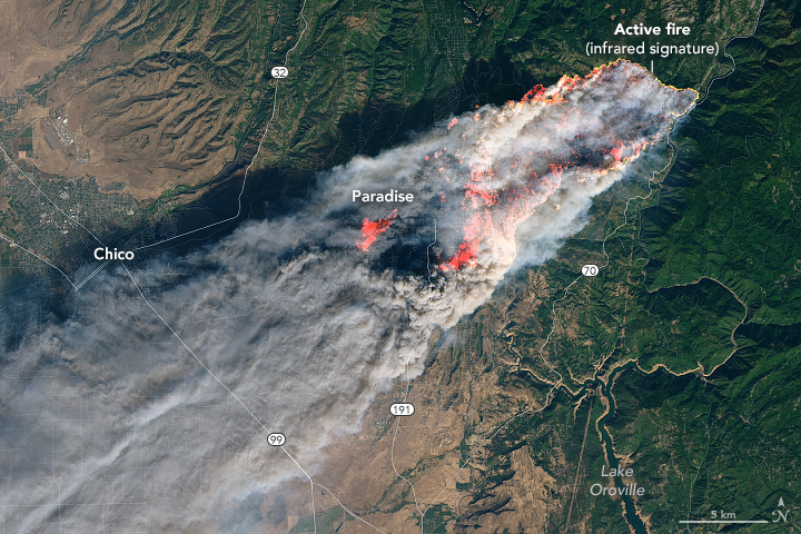
This image captured at 10:45AM yesterday, by the Landsat8 satellite shows the town of Paradise, CA fully engulfed in the fire. I have added annotations to the image to help identify landmarks.

On the morning of November 8, 2018, the Camp Fire erupted 90 miles (140 kilometers) north of Sacramento, California. By evening, the fast-moving fire had charred around 20,000 acres and remained zero percent contained, according to news reports.
The Operational Land Imager on Landsat 8 acquired this image on November 8, 2018, around 10:45 a.m. local time (06:45 Universal Time). The natural-color image was created using bands 4-3-2, along with shortwave infrared light to highlight the active fire.
NASA Earth Observatory image by Joshua Stevens, using Landsat data from the U.S. Geological Survey. Caption by Kasha Patel. Annotation by Anthony Watts.
DOWNLOAD LINKS TO MAKE PRINTS – right click and “save as” to save to your computer.
Original: https://wattsupwiththat.com/wp-content/uploads/2018/11/campfire-landsat8-large.jpg
With inset reference image https://wattsupwiththat.com/wp-content/uploads/2018/11/campfire-landsat8-large-inset-reference.jpg
Small reference image (used in inset above): https://wattsupwiththat.com/wp-content/uploads/2018/11/campfire-landsat8-small-annotated.jpg
Large image with labels: https://wattsupwiththat.com/wp-content/uploads/2018/11/TheCampFire-satellite.jpg
Anthony,
While we NEED you and WUWT please grab your servers and Kenji and evacuate as safety would require. We could live without WUWT for the short term if you need to shut it down. Of course it’s your call and I’m sure you will make the right one.
Safety first and this fire is really a threat to Chico. A threat of this magnitude with only a days warning is very serious.
Interesting article discussing the physics involved in these fires.
https://www.wired.com/story/the-terrifying-science-behind-californias-massive-camp-fire/
Neven defends rejoicing at deaths in Paradise on his forum .. worth a look ?
Ten pm news mentioned that the power company was having problems in the area just before the fire started. Several years ago, a cousin living in No Ca lost his home to one of those big fires and the fire was caused by the electric company. It took several years to receive his settlement. So, let’s wait to see what the real cause of this fire is before crying wolf.
My childhood spent living at the foot of the mountains in Chatsworth. I remember spending several summer evenings in a lawn chair watching the mountains burn. Anybody who has seen a Roy Rogers or Lone Ranger episode has a picture of the rugged landscape. But was a beautiful place to live 60 years ago.