Guest Post by Just The Facts
Introducing the new WUWT ENSO Forecast Page with an array of low skill forecasts…
 There are also several upgrades to the WUWT ENSO page, including new Sea Temperature Anomalies at depths. Lastly, WUWT reader “tim” points out in comments of the WUWT Ocean Page that “everybody is focusing on the Pacific at the moment, but “in the central Atlantic around the 10th may there seemed to be a large disturbance in the SST lasting around 2 weeks.” Animation to the left and analysis below.
The WUWT ENSO Forecast Page has actually been available for a few months, but I was hesitant to formally introduce it because “The period from February through May is commonly referred to as the spring barrier. During this time, models generally have the least skill to predict the coming season.” IRI “During April, May, and June, the state of the central Pacific is dynamic and can change quickly, making it hard to predict how it will behave in the coming months. In June, indications of potential strength should become more clear.”IRI
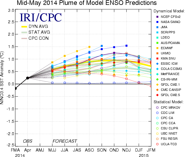
With this in mind, on May 16th Tony Barnston of the The International Research Institute (IRI) for Climate and Society noted that “Models are currently predicting El Niño of moderate strength, though a strong or weak El Niño is also still possible. Certainty in the strength has increased somewhat, though we are still within the time of the “’spring predictability barrier.’” “Tony Barnston expects a weak El Niño to continue to develop in the next few weeks. The IRI’s May ENSO forecast puts the chances of El Niño conditions at just under 70% for early next fall (see image at right), a slight decrease from IRI’s April forecast and from NOAA/IRI’s official prediction issued on May 8. A possible reason for the slightly lower probability is some weakness in the positive feedback loop typically seen in El Niño events between the atmosphere and warm ocean temperatures in the equatorial Pacific”
Here IRI’s Mid-May Plume of Model ENSO Predictions;
And here is NOAA’s Consolidated Niño 3.4 forecasts:

and Consolidated Standardized Niño 3.4 Anomaly Forecast:

In the two consolidation graphs above, it is interesting to note that the CFSv2 Arctic Sea Ice Extent prediction is for a positive anomaly in September and CFSv2 Niño 3.4 SST Anomalies forecast above is for a much stronger El Niño than it’s peers. below is CFSv2 Niño 3.4 SST Anomalies with the 16 most recent forecast members;

and here’s the 80 most recent forecast members:

Seems that they’ve certainly covered most of their bases. In addition to the fact that “for the predictions through the spring season in the growth phase of El Niño events, the prediction errors induced by both initial errors and model errors tend to have a prominent season-dependent evolution and yield a prominent spring predictability barrier (SPB)” Duan et al. , 2012, it is important to note that even after the SPB passes, our ENSO forecasting skills are abysmal, i.e.:
“ENSO conditions are represented by the Niño- 3.4 SST index in the east-central tropical Pacific. The skills of 20 prediction models (12 dynamical, 8 statistical) are examined. Results indicate skills somewhat lower than those found for the less advanced models of the 1980s and 1990s. Using hindcasts spanning 1981–2011, this finding is explained by the relatively greater predictive challenge posed by the 2002–11 period and suggests that decadal variations in the character of ENSO variability are a greater skill-determining factor than the steady but gradual trend toward improved ENSO prediction science and models.” Barnston et al. Given that, “Climate simulations suggest that multi-decadal periods of high and low variability in the phenomenon known as the El Niño-Southern Oscillation in the tropical Pacific Ocean may be entirely unpredictable” DiNezio, 1014, we cannot have confidence in any of our current ENSO forecasts
With these warnings applied, all of the ENSO forecasts above, as well as an array of others, can be found on the new WUWT ENSO Forecast Page.
In addition to the new ENSO Forecast Page, there are also some upgrades to the WUWT ENSO Page. When one views Sea Surface Temperatures;

and even Upper Ocean (300 Meters) Heat Anomalies;

one gets a 2 dimensional view of the Ocean Heat. However, the following Average Sea Temperature and Anomalies graphs at 55, 105 and 155 meters provides a view of what is occurring at three different depths below the surface. Here are Average Sea Temperature and Anomalies at 155 Meters:

105 Meters;

and 55 Meters:

Note how the area of large positive Sea Temperature Anomaly first appeared in early February at a depth of 155 meters, centered on longitude 160W. By late February had risen to 105 meters, centered on longitude 135W and by mid March had risen to 55 meters centered on 95W.
Here is an animation of weekly Equatorial Temperature Anomaly (Surface to 450 Meters) from Jan 18th – March 19th:

here is weekly from March 19th to May 18th;

and here is Equatorial Temperature and Anomaly monthly for the last 12 months:

The ENSO graphs above are now available on the WUWT ENSO page, as is the following Equatorial Upper-Ocean graph, which shows that Upper Ocean (300 Meters) Heat Anomalies reached a maximum in late March/early April, and then have slowly declined since then:

Aside from the WUWT ENSO pages and Equatorial Pacific, WUWT reader “tim” points out in comments of the WUWT Ocean Page, that “in the central atlantic around the 10th may there seemed to be a large disturbance in the SST lasting around 2 weeks.” Let’s take a look, here’s Global Sea Surface Temperature;

and here’s Equatorial Atlantic SST:

There definitely appears to have be a disturbance in Sea Surface Temperature between May 9th and 19th, Furthermore, the disturbance wasn’t just SST, it was also Sea Surface Height;

Speed / Currents;

and Sea Surface Salinity, where there is also an interesting coincident decrease in salinity off the coast of Africa:

Does anyone know what what might have caused of this disturbance? “tim” suggested that it might be a Submarine Volcano Near The Equator in The Atlantic Ocean, 1838, i.e.:
“The effect of a submarine eruption on a ship is described, by those seamen who have experienced it, to be similar to that of dragging the ship bodily along a roughly paved road; or like that violent shaking which the chain cable produces when running through the hawse; and this effect appears to have been felt in greater or less degree in the various instances now brought forward.”
“Mr. T. L. Huntley presents some volcanic ashes, collected at sea by Captain Ferguson, of the ship ‘Henry Tanner.’ These ashes were black, and had the same consistence as those of coal. The spot where they were picked up was 0 degrees 35′ S and 15 degrees 50′ W., the sea being in a violent agitation. In a former voyage, made by the same officer and almost in the same place, lat 1 degree 35′ S. and 20 degrees 27′ W., he had been alarmed by hearing a very great noise. The captain and officers thought the ship had struck on a coral rock; but in sounding they could not reach the bottom.”
Here’s picture of a Submarine volcano disturbing the sea surface in 2011;

with associated commentary, “Whitecaps churn in the Atlantic off West Africa as an underwater volcano erupts off Spain’s Canary Islands on Monday. Since last week, the volcano has been spewing gas and fragments of smoking lava, staining the ocean surface green and brown, as seen above. Spanish authorities have closed a port on Hierro island, ordered ships away from the island’s village of La Restinga, and banned aircraft from flying over the island’s southern tip, according to the AFP news service.” Crystalinks
Please post your thoughts on what might have caused the Equatorial Atlantic disturbance in comments below or on the WUWT Ocean Page. In addition to the WUWT Ocean Page, WUWT ENSO Page and new WUWT ENSO Forecast Page, if you have not had the opportunity to review some our other WUWT Reference Pages, they are highly recommended:
- Atmosphere Page
- Atmospheric Oscillation Page
- ENSO (El Niño/La Nina Southern Oscillation) Page
- ENSO Forecast Page
- “Extreme Weather” Page
- Geomagnetism Page
- Global Climate Page
- Global Temperature Page
- Great Lakes Ice Page
- Northern Polar Vortex Page
- Northern Regional Sea Ice Page
- Ocean Page
- Oceanic Oscillation Page
- Polar Vortex Page
- Paleoclimate Page
- Potential Climatic Variables Page
- Sea Ice Page
- Solar Page
- Spencer and Braswell Papers
- Tornado Page
- Tropical Cyclone Page
- US Climate Page
- US Weather Page
Please note that WUWT cannot vouch for the accuracy of the data within the Reference Pages, as WUWT is simply an aggregator. All of the data is linked from third party sources. If you have doubts about the accuracy of any of the graphs on the WUWT Reference Pages, or have any suggested additions or improvements to any of the pages, please let us know in comments below.
Discover more from Watts Up With That?
Subscribe to get the latest posts sent to your email.
Living here in central Ca, I am hoping for a strong enough El Niño to alarm the alarmists . The precipitation it would bring will surely be another example of “Climate Change” as well as climate change. I will suffer those fools in exchange for the rain.
I am hoping for at least 20 in of rain next water year. It is not too much to ask for.
I believe the effects of the negative PDO will work toward a weaker ENSO event than predicted. Does anyone know of research on this point?
Ok.. I’ll say it:
Gojira?!?!
I am completely mesmerized by the anomaly.
I’m also fascinated while watching my hard drive being de-fragged.
The volume of seawater, being churned in a few days is just amazing. The speed of the rising cold water volume from 10,000′ below sea level, with an area the size of the Philippines.
90,000 cubic miles of water moving vertically at about one mph..
Say how many horse power would be needed to duplicate this event?….
upcountrywater says:
May 27, 2014 at 10:45 pm
I am completely mesmerized by the anomaly.
I’m also fascinated while watching my hard drive being de-fragged.
What PC operating system do you use? In older windows versions there was this nice graphic display of the shifting colored squares as defrag proceeded. But in Vista and Windows 7 this was removed (unless there’s a way to get it back?)
The Atlantic disturbance is in the same area where the Air France flight 447 crashed on June 1, 2009. Just saying…
phlogiston says:
What PC operating system do you use?
That would be : Raxco Perfect Disk 10 …