Shortlink for this page: http://wp.me/P7y4l-8Fp (suitable for blog or Twitter comments)
Ocean Temperature Anomalies
Global Sea Surface Temperature Anomaly – NCDC/ERSST (climate4you)

climate4you.com – Ole Humlum – Click the image to view at source
Global Sea Surface Temperature Anomaly – HadSST3

climate4you.com – Ole Humlum – Click the image to view at source
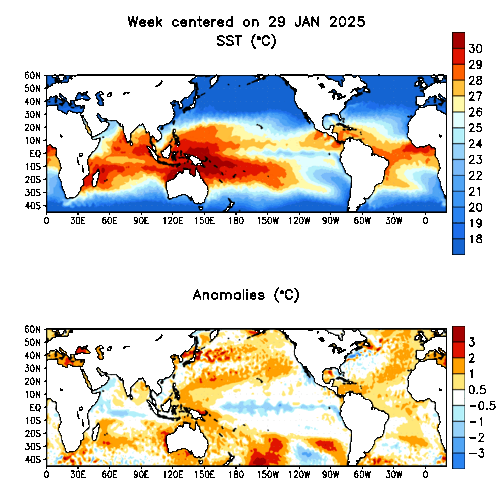
Global Sea Surface Temperature Anomaly – Daily (NOAA PSL)

NOAA – Physical Sciences Laboratory (PSL) – Click the image to view at source
Global Sea Surface Temperature Anomaly – Weekly (NOAA PSL)

NOAA – Physical Sciences Laboratory (PSL) – Click the image to view at source
Global Sea Surface Temperature Anomaly – Monthly (NOAA PSL)

NOAA – Physical Sciences Laboratory (PSL) – Click the image to view at source
Ocean Temperature
Global Sea Surface Temperature – Daily (NOAA PSL)

NOAA – Physical Sciences Laboratory (PSL) – Click the image to view at source
Global Sea Surface Temperature – 3 Months – NOAA CPC:
https://www.cpc.ncep.noaa.gov/products/analysis_monitoring/enso_update/gsstanim.gif
Custom Sea Surface Temperature Mapping Tool – from 1981 – NOAA GODAS:
https://www.cpc.ncep.noaa.gov/products/GODAS/
Equatorial Pacific Sea Surface Temperature – NOAA CPC – 3 Months:
https://www.cpc.ncep.noaa.gov/products/analysis_monitoring/enso_update/sstanim.gif
Global & Equatorial Pacific SST Animations – Current and Forecast:
• HYCOM Global Analysis Products
• earth.nullschool.net – Live Global Ocean Temperature
Ocean Subsurface Temperature
Global Oceanic Temperature Anomaly – 0–700 Meters – 1979 to Present (climate4you)

climate4you.com – Ole Humlum – Click the image to view at source
NOAA/NCEI Global Ocean Heat Content – 0–700 Meters – 1955 to Present:
https://www.ncei.noaa.gov/access/global-ocean-heat-content/
NOAA GODAS – Equatorial Pacific and Global Subsurface Temperature Monitoring:
https://www.cpc.ncep.noaa.gov/products/GODAS/
Australian Bureau of Meteorology – Subsurface Ocean Temperature Products:
https://www.bom.gov.au/oceanography/
Sea Level
Global Mean Sea Level Change – 1993 to Present (climate4you)

climate4you.com – Ole Humlum – Click the image to view at source
Global Mean Sea Level – Current Release (University of Colorado at Boulder)
Note: A Glacial Isostatic Adjustment (GIA) correction of 0.3 mm/year is applied to this dataset.

University of Colorado at Boulder – Sea Level Research Group – Click the image to view at source
NOAA/NCEI Sea Level Monitoring:
https://www.ncei.noaa.gov/access/monitoring/global-sea-level/
NOAA/NCEI Thermosteric Sea Level Anomaly – Ocean Heat Content Page:
https://www.ncei.noaa.gov/access/global-ocean-heat-content/
Global Sea Surface Height – Current and Animated:
• HYCOM Global SSH Analysis Products
• Copernicus Marine Service – Ocean Viewer
NASA JPL – Ocean Surface Topography from Space:
https://sealevel.jpl.nasa.gov/
Dave Burton – Sea Level Info (independent tide gauge and satellite altimetry synthesis):
https://sealevel.info/
Salinity
Global Sea Surface Salinity – Current and Animated:
• HYCOM Global Salinity Analysis Products
• Copernicus Marine Service – Salinity
• earth.nullschool.net – Live Global Ocean Salinity
Ocean Speed / Currents
Global and Regional Ocean Currents – Current and Animated:
• earth.nullschool.net – Live Global Ocean Currents
• HYCOM Global Currents Analysis Products
• Copernicus Marine Service – Ocean Viewer
Regional ocean model products for Atlantic, Indian, Pacific, and Polar Oceans:
HYCOM Consortium – Regional Models |
NRL Monterey Marine Meteorology Division
Source Guide
Australian Bureau of Meteorology (BoM)
Home Page – https://www.bom.gov.au/
Climate Page – https://www.bom.gov.au/climate/
ENSO Monitoring – https://www.bom.gov.au/climate/enso/
Oceanography – https://www.bom.gov.au/oceanography/
climate4you.com – Ole Humlum
Home Page – https://climate4you.com/
Ole Humlum Bibliography – https://climate4you.com/Text/BIBLIOGRAPHY%20OLE%20HUMLUM.pdf
Copernicus Marine Service (CMEMS)
Home Page – https://marine.copernicus.eu/
Ocean Viewer – https://marine.copernicus.eu/access-data/ocean-visualisation-tools
earth.nullschool.net – Live Global Earth Visualization
Ocean Currents – https://earth.nullschool.net/#current/ocean/surface/currents/orthographic
Ocean Temperature – https://earth.nullschool.net/#current/ocean/surface/temp/orthographic
Ocean Salinity – https://earth.nullschool.net/#current/ocean/surface/salinity/orthographic
HYCOM Consortium (Global Ocean Forecast System)
Home Page – https://www.hycom.org/
Global Analysis Products – https://www.hycom.org/dataserver/glb-analysis
NOAA – Physical Sciences Laboratory (PSL) (formerly Earth System Research Laboratory / ESRL)
Home Page – https://psl.noaa.gov/
SST Maps – https://psl.noaa.gov/map/clim/sst.shtml
Data Page – https://psl.noaa.gov/data/
NOAA – National Centers for Environmental Information (NCEI) (formerly NODC and NCDC)
Home Page – https://www.ncei.noaa.gov/
Global Ocean Heat Content – https://www.ncei.noaa.gov/access/global-ocean-heat-content/
OISST Product – https://www.ncei.noaa.gov/products/optimum-interpolation-sst
ERSST Product – https://www.ncei.noaa.gov/products/extended-reconstructed-sst
Sea Level Monitoring – https://www.ncei.noaa.gov/access/monitoring/global-sea-level/
NOAA – Climate Prediction Center (CPC)
Home Page – https://www.cpc.ncep.noaa.gov/
Products Page – https://www.cpc.ncep.noaa.gov/products/
GODAS Ocean Data Assimilation System – https://www.cpc.ncep.noaa.gov/products/GODAS/
Atmospheric & SST Indices – https://www.cpc.ncep.noaa.gov/data/indices/
Naval Research Laboratory (NRL) – Monterey Marine Meteorology Division
Home Page – https://www.nrlmry.navy.mil/
Satellite Products – https://www.nrlmry.navy.mil/sat_products.html
StormSurf.com
Home Page – https://www.stormsurf.com/
Model Products – https://www.stormsurf.com/mdls/menu.html
Global Jet Stream / 250 mb – https://www.stormsurfing.com/cgi/display_alt.cgi?a=glob_250
North Atlantic Surface Pressure – https://www.stormsurfing.com/cgi/display.cgi?a=natla_slp
Unisys Weather Information Systems
Home Page – https://weather.unisys.com/
Analyses Page – https://weather.unisys.com/analyses.php
University of Colorado at Boulder – Sea Level Research Group
Home Page – https://sealevel.colorado.edu/
Current Release – https://sealevel.colorado.edu/files/current/
Release Notes – https://sealevel.colorado.edu/content/release-notes
NASA – Jet Propulsion Laboratory – Ocean Surface Topography from Space
Home Page – https://sealevel.jpl.nasa.gov/
Additional Resources
University of Alabama at Huntsville – Roy Spencer PhD
Home Page – https://www.drroyspencer.com/
Global Temp Page – https://www.drroyspencer.com/latest-global-temperatures/
Cooperative Institute for Meteorological Satellite Studies (CIMSS) / Space Science and Engineering Center (SSEC)
CIMSS Home – https://cimss.ssec.wisc.edu/
CIMSS Products – https://cimss.ssec.wisc.edu/data/
SSEC Home – https://www.ssec.wisc.edu/
Coriolis Operational Oceanography
Home Page – https://www.coriolis.eu.org/
Data & Products – https://www.coriolis.eu.org/Data-Services-Products/View-Download/
European Centre for Medium-Range Weather Forecasts (ECMWF)
Home Page – https://www.ecmwf.int/
Forecasts – https://www.ecmwf.int/en/forecasts
Charts – https://charts.ecmwf.int/
IRI/LDEO Climate Data Library – Columbia University
Home Page – https://iridl.ldeo.columbia.edu/
Atmospheric Circulation Products – https://iridl.ldeo.columbia.edu/maproom/.Global/.Atm_Circulation/
Atmospheric Temperature – https://iridl.ldeo.columbia.edu/maproom/.Global/.Atm_Temp/
Weather Models – Ryan Maue (NCEP GFS, NAM, ECMWF)
https://weathermodels.com/
Dave Burton – Sea Level Info (independent tide gauge and satellite altimetry synthesis)
https://sealevel.info/
I know everybody is focusing on the Pacific at the moment, but is there any details on the event in the central atlantic around the 10th may there seemed to be a large disturbance in the SST lasting around 2 weeks.
tim says: May 19, 2014 at 9:21 pm Naval Research Laboratory (NRL) – Monterey Marine Meteorology Division – Click the pic to view at source[/caption]
 Naval Research Laboratory (NRL) – Monterey Marine Meteorology Division – Click the pic to view at source[/caption]
 Naval Research Laboratory (NRL) – Monterey Marine Meteorology Division – Click the pic to view at source[/caption]
 Naval Research Laboratory (NRL) – Monterey Marine Meteorology Division – Click the pic to view at source[/caption]
 Naval Research Laboratory (NRL) – Monterey Marine Meteorology Division – Click the pic to view at source[/caption]
I know everybody is focusing on the Pacific at the moment, but is there any details on the event in the central atlantic around the 10th may there seemed to be a large disturbance in the SST lasting around 2 weeks.
Good catch, not sure what to make of that:
[caption id="" align="alignnone" width="600"]
[caption id="" align="alignnone" width="600"]
And the disturbance wasn’t just temperature, it was also Sea Surface Height;
[caption id="" align="alignnone" width="600"]
Speed / Currents
[caption id="" align="alignnone" width="600"]
and Sea Surface Salinity, where there is also an interesting coincident decrease in salinity off the coast of Africa:
[caption id="" align="alignnone" width="600"]
No sure what that is. There was a “Moderate earthquake – Southern Mid Atlantic Ridge on May 10, 2014”, but I don’t know if this would be strong enough to create such a disturbance. I’ll put it in an article to see if anyone else knows what it was.
time lat long depth mag
2014-05-25T01:39:17.630Z -1.0177 -14.4194 10 4.6
2014-05-24T11:49:26.070Z 0.6863 -26.3229 10 5.9
2014-05-21T20:51:58.180Z -11.1502 -13.0324 10 4.7
2014-05-21T15:02:46.280Z 0.0959 -16.838 15.52 4.6
2014-05-16T21:11:29.100Z -10.3964 -13.2339 10 5.1
2014-05-14T19:09:31.950Z -1.2829 -16.1957 10 4.6
I think these activities on the Ridge will satisfy your specifications. I searched only for >Mag 4.5. Although such Mags will cause a hurricane, these are too close to the Equator to do so.
Sorry about the formatting but the data I actually posted here were in columns!
Thanks, I was thinking perhaps a large underwater eruption may have disturbed the water column causing an upwelling of both warm and cold water but i couldn’t find any corresponding seismic activity. I believe the earthquake you noted was much further south along the ridge, which made me sceptical that it could have triggered the event near the equator.
Good catch, Tim. Volcanic activity along submarine ridges is barely noticed, unless it coincides with earthquake activity serious enough to warrant a tsunami watch. Not all volcanic activity is explosive or even abrupt, as can be seen at Kilauea. A gradual oozing of lava will dump a lot of heat into a limited area of the ocean. A similar situation occurred when the Gakken Ridge exuded a huge lava flow into the Arctic floor – at a time roughly coincident with the onset of the anxiety about reduction in the annual minimum of the Arctic ice cover.
Looks like the middle of the South Atlantic Gyre. Could it have swept in something that jacked measurements?
That anomaly on the 10th May appears to be in the region of Ascension Island, which is a dormant volcano. I’d suggest there may have been a major eruption in an underwater vent in the area. I believe there is a lot of volcanic activity there.
The University of Colorado at Boulder sea level graph,
http://sealevel.colorado.edu/files/2013_rel8/sl_ns_global.png
appears to be superseded with
http://sealevel.colorado.edu/files/2014_rel4/sl_ns_global.png
However, it only goes up to fractional date 2014.1893 so is not very up-to-date itself.
Ric Werme August 31, 2014 at 1:47 pm
The University of Colorado at Boulder sea level graph, appears to be superseded
Yes, updated on this page and the Global Climate page. Thank you
According to Sea Level Rise (NOAA-NESDIS-STAR Laboratory for Satellite Altimetry), at http://www.star.nesdis.noaa.gov/sod/lsa/SeaLevelRise/ the uncertainty of this measurement is 3–4 mm.
Here’s a great example of how easily humans can deal with sea level –
http://www.bc.edu/bc_org/avp/cas/fnart/fa267/boston/sequ_ani.gif
Credit to by Jeffery Howe, Boston College, 1996
Site – http://www.bc.edu/bc_org/avp/cas/fnart/fa267/sequence.html
“Climate4you.com – Ole Humlum – Global Ocean Heat Content – 0-700 Meters – 1955 to Present”
and
“Global Mean Sea Level Change – 1993 to Present:”
are identical graphs … you should fix that ..
Corrected, thank you!
Are there any ideas what the hemispheric emissivity of water is? I am only asking, because if emissivity is to be derived from a fresnel equation with n = 1.27, as indicated here
https://scienceofdoom.com/2010/12/27/emissivity-of-the-ocean/
..then total hemispheric emissivity would equal 0.84, if I did the math correctly.
Next, if absorptivity was about 0.94 (on which there seems to be a consenus), and a PBB temperature was 279.2, then of course water should naturally yield a temperature of (0.94/0.84)^0.25 * 279.2 = 287.2K. A result that jeopardizes the GHE theory.
Read about jet streams being accelerated by mid-latitude oxygen/ozone conversion which extends Rossby wave meander loops. Study the new theory on your desktop at this dedicated website:
https://www.harrytodd.org
Ocean suffers from offshore wind farms pollution. I mean, that when inspection fails and pieces (or in some cases the whole wind blade) falls into the ocean and harm it dramatically. For that reason, technicians must pay attention to maintenance and inspections in order to take care of environment
How relevant is submarine magma production in the debate over rising oceans?
If the global production of magma is: 20–25 cubic kilometers per year
· And 70% of magma is produce globally is the result of submarine volcanos
· Then 17.2 cubic Kilometers of magma is adding volume to the oceans annually.
· And a one inch rise in sea level requires 9195 Cubic Kilometers of volume
o The area of the world ocean is about 362 million square kilometers.
o One inch is 2.54 cm, which works out to 2.54 x 10^-5 km.
o (390 x 10^6 km^2) x (2.54 x 10^-5 km) = 9195 km^3 = 9195 cubic kilometers.
·Based on annual magma production alone, sea surfaces should rise almost 2 inches a year.
I understand this is a simplistic observation as there are many other variables and complications that contribute to sea level variation.
Other Factors?
o Water Temperature,
o Gravitational variation (earth and cosmic)
o Eruptions and earthquakes opening new volumes in the sea floor, (fissures, fractures etc)
o Ice freeze and melt
o Precipitation cycles
o Volume of animal and plant life in the ocean