The Southern Oscillation Index has been mentioned often in comments at WattsUpWithThat, in this series of blog posts about the upcoming El Niño. Curiously, Australia’s BOM Southern Oscillation Index for April 2014 is at a positive value that’s near to La Niña conditions, while the sea surfaces of the equatorial Pacific are now warming toward El Niño conditions. What gives?
We recently discussed the Southern Oscillation Index in the post El Niño and La Niña Basics: Introduction to the Pacific Trade Winds. In this post, I’ll only offer a brief introduction to the Southern Oscillation Index, so if you’d like a little more information, please refer to that post. Then, after the presentation of the BOM Southern Oscillation Index dataset, we’ll discuss the Equatorial Southern Oscillation Index data available from NOAA.
SOUTHERN OSCILLATION INDEX
The Southern Oscillation Index (SOI) is one of many indices that are used to document the timing, frequency and duration of El Niño and La Niña events. The Southern Oscillation Index represents the differences in the sea level pressures between Tahiti and Darwin, Australia…with the Darwin sea level pressures subtracted from those in Tahiti. See Figure 1 for the locations of both. The source of the illustration is the climate.gov webpage Climate Variability: Southern Oscillation Index. The INDO and EPAC regions are used for a similar index called the Equatorial Southern Oscillation Index, which we’ll discuss later.

Figure 1
The Southern Oscillation was first observed by Sir Gilbert Walker back in the 1920s but, if memory serves, it wasn’t associated with El Niño and La Niña events until the 1960s.
The positive value for the Southern Oscillation Index in April indicates the sea level pressure in Tahiti was higher than the sea level pressure in Darwin, which in turn indicates that the trade winds (those located off the equator in the Southern Hemisphere) were stronger than normal in April, blowing from east (Tahiti) to west (Darwin). Stronger-than-normal trade winds are typically associated with La Niña events, not El Niño events. A negative value would indicate the opposite…that the sea level pressure in Tahiti is lower than the sea level pressure in Darwin, which in turn indicates that westerlies are blowing from west to east. And a negative value is what we’d expect during an El Niño.
Then again, the El Niño hasn’t developed yet.
Figure 2 compares the Southern Oscillation Index values so far this year to the values during the development of the 1982/83 and 1997/98 El Niño. Again, we’re using those two strong El Niños as reference because some indicators are suggesting the developing El Niño may be strong. The Southern Oscillation Index had been decreasing as we would expect during the development of an El Niño, but then it made a quick change in April. Is that a concern if you’re looking forward to an El Niño this year? Nope.

Figure 2
Figure 3 is a spaghetti graph. It compares the evolution of the Southern Oscillation Index so far this year in red to the evolutions of the 1986/87/88 El Niño, 1991/92 El Niño, 1994/95 El Niño, 2002/03 El Niño, 2004/05 El Niño, 2006/07 El Niño and the 2009/10 El Niño. As shown, the Southern Oscillation Index has been positive even later in the year during the development of an El Niño. (See the Oceanic NINO Index for the “official” El Niño events.)

Figure 3
One of the difficulties with the Southern Oscillation Index is that it is based on sea level pressures for locations that are off of the equator, while El Niño events take place along the equator in the Pacific. The second complication is that the sea level pressures are measured at two specific locations and that means they are very susceptible to changes in local weather. This was discussed back in 1997 in a paper by Kevin Trenberth The Definition of El Niño. There Trenberth wrote:
Various versions of the SOI exist although, in recent years, most deal only with atmospheric pressures and usually only those at Darwin and Tahiti. In using the SOI based on just two stations, it must be recognized that there are many small scale and high frequency phenomena in the atmosphere, such as the Madden-Julian Oscillation, that can influence the pressures at stations involved in forming the SOI, but which do not reflect the Southern Oscillation itself. Accordingly, the SOI should only be used when monthly means are appropriately smoothed (Trenberth 1984, Trenberth and Hoar 1996a).
[Trenberth (1984) is Signal Versus Noise in the Southern Oscillation. And Trenberth and Hoar (1996a) is The 1990-1995 El Niño-Southern Oscillation Event: Longest on record, which was an early attempt to tie El Niño events to manmade global warming. That period has now been broken down into 2 “official” El Niño events, according to the Oceanic NINO Index.]
In Trenberth (1984), he presented the results after smoothing the Southern Oscillation Index data with an “11-term low-pass filter.” That wouldn’t help us in this short-term look, so let’s use a simple 3-month running mean. (NOAA uses the 3-month running mean for a version of its Equatorial SOI data, to be discussed later.) Figures 4 and 5 present the same comparisons as the earlier two graphs, but in them the Southern Oscillation Index values have been smoothed with 3-month running-mean filters. As shown in Figure 4, with that minor filtering, the current evolution does not look out of place compared to the 1982/83 El Niño or the 1997/98 El Niño. And the current evolution appears within the range of the other El Niño events since 1986. See Figure 5.
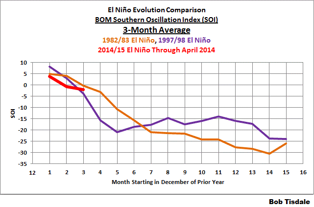
Figure 4
# # # # # #

Figure 5
But that still doesn’t help us with the fact that the reference points for the Southern Oscillation Index are off the equator while El Niño events are focused along the equator in the Pacific. Thus…
NOAA’S EQUATORIAL SOUTHERN OSCILLATION INDEX
In their Climate Prediction Center Equatorial Southern Oscillation Index (1949-present) webpage, NOAA describes the dataset as:
Abstract:
This is one of the CPC’s Monthly Atmospheric and SST Indices. It contains Equatorial Southern Oscillation Index (standardized sea level pressure differences between EPAC (5N-5S, 80W-130W) and INDO (5N-5S, 90E-140E)) for the period of 1949-present. The anomalies are departures from the 1981-2010 base period means.
Purpose:
This index is constructed for applications in climate monitoring, climate analysis and verifications of numerical models.
Please refer to Figure 1 again for the locations of the EPAC and INDO regions. Because they are comparatively large regions, they should be less susceptible to weather noise, and because they are located along the equator, they should better capture the equatorial trade winds. The Equatorial Southern Oscillation Index is calculated in a similar fashion. It represents the sea level pressure difference between the eastern equatorial Pacific (EPAC) and the sea level pressure of equatorial Indonesia (INDO)…with INDO subtracted from EPAC.
The Equatorial Southern Oscillation Index data are available from the NOAA Monthly Atmospheric & SST Indices webpage. The Indonesia (INDO) sea level pressure data (standardized) are here, the Eastern Equatorial Pacific (EPAC) sea level pressure data (standardized) are here, and the Equatorial Southern Oscillation Index data are here (and it appears the difference is then standardized as well.) NOAA also provides the Equatorial Southern Oscillation Index data as a 3-month running mean here. But there really doesn’t appear to be the same need to smooth the Equatorial Southern Oscillation Index data, as you shall see.
Figure 6 compares the Equatorial Southern Oscillation Index values so far this year to the values during the development of the 1982/83 and 1997/98 El Niño. The evolution this year falls in line with the two strong El Niños.

Figure 6
Compared to the other El Niño evolutions, Figure 7, this year appears to be the stronger (more negative) than normal at this stage.

Figure 7
And for those who would like to see the comparisons with the Equatorial Southern Oscillation Index data smoothed with the 3-month running means see Figures 8 and 9.

Figure 8
# # # # # #

Figure 9
COMPARISON OF THE TWO SOUTHERN OSCILLATION INDICES
Figure 10 compares the BOM Southern Oscillation Index data to the NOAA Equatorial Southern Oscillation Index data. The BOM also multiplies their SOI data by 10 after standardizing it, so for the comparison I scaled it back by dividing their data by that factor. The correlation between the two indices is not as good as one might suspect, with a correlation coefficient of 0.77.

Figure 10
And NOAA’s Equatorial Southern Oscillation Index data correlates better (-0.83) with NINO3.4 sea surface temperature anomalies (Kaplan SST) than does the BOM Equatorial Southern Oscillation Index data (-0.71).
CLOSING
The Southern Oscillation Index from BOM has been around for a long time. It is a commonly used ENSO index. It is noisy and, at times, does not appear to reflect what’s taking place along the equatorial Pacific. Then again, it is much studied with respect to its impact on weather in Australia and New Zealand.
It appears that NOAA’s Equatorial Southern Oscillation Index better reflects what’s taking place along the equator in the Pacific, where ENSO events take place, but it is not as popular as the BOM SOI.
EARLIER POSTS IN THIS SERIES
- The 2014/15 El Niño – Part 1 – The Initial Processes of the El Niño.
- The 2014/15 El Niño – Part 2 – The Alarmist Misinformation (BS) Begins
- The 2014/15 El Niño – Part 3 – Early Evolution – Comparison with 1982/83 & 1997/98 El Niño Events
- The 2014/15 El Niño – Part 4 – Early Evolution – Comparison with Other Satellite-Era El Niños
- The 2014/15 El Niño – Part 5 – The Relationship Between the PDO and ENSO
- The 2014/15 El Niño – Part 6 – What’s All The Hubbub About?…
- The 2014/15 El Niño – Part 7 – May 2014 Update and What Should Happen Next
And for additional introductory discussions of El Niño processes see:
- An Illustrated Introduction to the Basic Processes that Drive El Niño and La Niña Events
- El Niño and La Niña Basics: Introduction to the Pacific Trade Winds
- La Niñas Do NOT Suck Heat from the Atmosphere
- ENSO Basics: Westerly Wind Bursts Initiate an El Niño
FURTHER READING
My ebook Who Turned on the Heat? goes into a tremendous amount of detail to explain El Niño and La Niña processes and the long-term aftereffects of strong El Niño events. Who Turned on the Heat? weighs in at a whopping 550+ pages, about 110,000+ words. It contains somewhere in the neighborhood of 380 color illustrations. In pdf form, it’s about 23MB. It includes links to more than a dozen animations, which allow the reader to view ENSO processes and the interactions between variables.
I’ve lowered the price of Who Turned on the Heat? from U.S.$8.00 to U.S.$5.00. A free preview in pdf format is here. The preview includes the Table of Contents, the Introduction, the first half of section 1 (which was provided complete in the post here), a discussion of the cover, and the Closing. Take a run through the Table of Contents. It is a very-detailed and well-illustrated book—using data from the real world, not models of a virtual world. Who Turned on the Heat? is only available in pdf format…and will only be available in that format. Click here to purchase a copy. Thanks. Book sales and tips will hopefully allow me to return to blogging full-time once again.
El Nino…La Nina are meaningless terms which have been latched onto by ‘Cyclists’.
The dearth of comprehensive, long term data on the behaviour of the ‘Pacific Ocean’ means that we are a long way off understanding its basic mechanisms, let alone predicting its effect on climate.
I still chuckle at the claim made in a recent piece where someone solemnly pronounced that they had detected a 15 year cyclical .5C variation in the temperature of the ‘North Atlantic’!!!!
Still love the posts though.
The issue isn’t that there won’t be an el nino, the SOI showed a positive result in April and the ENSO began faltering in April (until the kelvin began surfacing in the last days of April and the SOI went negative big time again). But now it’s once again positive. Kevin’s tunnel vision, whom I feel has really influenced your own analysis should be kept in mind.
The SOI is just a reflection of what the winds are doing. That’s no small thing.
This is what i’ve been saying to people. It’s not just a study of kelvin waves which determines el ninos. Kelvins are only ONE factor. You have to look at everything. You have to treat an el nino as a living thing that feeds off different things. March showed a major spike in ocean temps and created a strong kelvin wave (likely due to the solar spike in January and February). It appeared similar to events in 1997. Thus, you can understand why people suspected it might be so strong. But, alarmists being what they are, began predicting “super el nino” and “warmest year ever” before all the facts were in. Now that things slowed in April and other indicators are showing a weaker el nino, they continue to beat the drums no matter what the data shows. This looks like the 2002-3 el nino, just like Joe Bastardi has said. I have felt that for a while.
Something else has to happen to give this el nino some power. Because right one kelvin wave, even a strong one, isn’t doing it. This isn’t even going to be a strong el nino, much less biggest ever.
FWIW, climate scientists seem to be focusing on natural variability again which in the long run may be a positive development.
Shouldn’t it be quite straight forward to compute a temperature index where the effects of ENSO and volcanic eruptions are removed or at least strongly suppressed? That way, to major sources of variability would be removed from global temperature data and the effect from CO2 could be observed without waiting several decades?
Thanks Bob.
Seems like a good time to wait.
The correlation coefficient of 0.77 may even be less useful than it sounds if the variables do not meet the assumptions for the use of Pearson’s r. It is not likely a big deal. The NOAA Eq.SOI seems a better fit to the concept but the Tahiti-Darwin series has historical inertia.
Often wonder whether the index really is more of a trailing indicator at least for rainfall in Eastern Australia. We have recently gone through the driest summer in over 50 years in large parts of the sub-tropics with a nominally neutral SOI. One of the greater frustrations for landholders (farmers predominantly) in making management decisions regarding cropping is the predictive usefulness of the index required to make crucial judgements about planting and inputs often only emerges after the time after which planting of winter crops is normally completed (or nearly completed) to achieve optimum yield.
I recently sat in on a presentation from Dr Roger Stone (Centre for Climate Applications?) who mentioned the QBO (Quasi biennial Oscillation) and the importance of this feature (amongst others) in influencing rainfall incidence in this region. This index appears to get little or no airplay in popular media though it is claimed to be a very important metric in shaping the underlying effects described by other more commonly canvassed indices such as the SOI and IOD (Indian Ocean Dipole). Bob, could you please elucidate the influence of this index (if you are familiar with it) on evolution of rainfall patterns in the western Pacific?
Thankyou,
Andrew
Very well presented. The BOM index, being south of the equator will better represent the southern hemisphere trades. The equatorial indices strive for some sort of average, and it would be really nice to have yet another index proportionately north of the equator to catch the northern hemisphere gradient.
In a sense the BOM is a better index because the Niño typically expresses as a southern hemisphere warm season/northern season cool season event.
The bottom line is that the warm water can pile up all it likes, and the various reaction waves can try to reflect it back all they like, but until the trade winds quit pulling bottom water up off the coasts of the Americas and dousing the party, you can have moderate to strong ninos, but not a supaare nino.
Thanks Bob, for a good logical presentation. It will be interesting to follow the progress of this system during 2014.
And, I can strongly recommend “Who Turned on the Heat?” to fill in the details.
Andrew Somerville:
I wonder the same thing, but I see it especially at the end of an El Nino, when a severe drought is broken by heavy rain some months before the SOI indicates the end of the El Nino. Spectacular example of this was the 82-83 event. The SOI is a very blunt instrument for prediction. Current 30 day average is near zero again, so generally declining despite the recent surge (which may have reflected the late wet season rain events and cyclones.)
Ken Stewart
Bob, do you think that the huge pool of very cold water across much of the western northern pacific may make a difference in this El Nino?
Sorry Bob, I can not accept anything Trenberth writes or says. He has no understanding of heat transfer unless he tells lies to support his theories.
per dessis w above :
which might be due in part, to the very active 2013 tropical cyclone season in the Western Pacific ?
sorry, that was dennis w, above.
I live in Hervey Bay, on the East coast of Australia. The last week or so has been cold and set – unusual weather for a subtropical region, and not what you would expect if the surface waters of our end of the Pacific were heating up.
Wouldn’t be surprised if this El Nino were a fizzle.
Charles Nelson says: “El Nino…La Nina are meaningless terms which have been latched onto by ‘Cyclists’.”
That’s odd. I write these posts, and the last thing that I am is a “cyclist”.
Jeff says: “Something else has to happen to give this el nino some power.”
Agreed. And there are a few more months for that something else to happen. It’s going to take a LOT of westerly wind bursts in the western tropical Pacific for this El Nino to catch up with the 1997/98 El Nino.
Londo says: “Shouldn’t it be quite straight forward to compute a temperature index where the effects of ENSO and volcanic eruptions are removed or at least strongly suppressed?”
The effects on climate of ENSO and volcanic eruptions are quite different. Aerosols spewed into the stratosphere by a volcanic eruption reduce downward shortwave radiation (visible sunlight) reaching the surface…the impact of which is sometimes debated. ENSO acts as a recharge-discharge oscillator, where an El Niño discharges heat, and a La Niña recharges it by allowing sunlight to warm the tropical Pacific. But ENSO also varies the distribution of warm water from tropical Pacific toward the poles and into adjoining basins. Looking at it from a different perspective, La Niña events are not the opposite of El Niño events, and there are no indices that account for the differences. We’ve discussed this in the past a number of times. Examples:
http://bobtisdale.wordpress.com/2012/11/28/rahmstorf-et-al-2012-insist-on-prolonging-a-myth-about-el-nino-and-la-nina-2/
And:
http://bobtisdale.wordpress.com/2012/01/14/revised-post-on-foster-and-rahmstorf-2011/
Regards
Bob
Whilst dairy farming in Rhodesia in the early 70’s my wife and I used the el nino index and the winter rains in the south african cape to guess the coming seasons rain. To plant maize in granite sandveld wet land or not. Years of work in the hydrological field taught me to observe rather than play statistical games. Now we live in the NZ in the vast pacific southern ocean surrounded by warm water and near to 80% of the worlds ice. NZ seasonal predictions for the coming season are generally rather poor and badly explained. So it would be great if someone could produce a simple explanation for farmers – something like the delightful Climate Dogs video produced by the OZ Vic Govt. It would make following your graphs easier and hammer home the fact that this vast body of water controls a very large portion of the world weather. Thank you for all the effort you put into the subject.
Andrew Somervaille: Sorry, the Quasi Biennial Oscillation is not one of my areas of research. Hopefully, one of the meteorologists who frequent here will have something to offer.
The BOM has a relatively detailed discussion of the influence of the Indian Ocean Dipole on Australian weather.
http://www.bom.gov.au/climate/IOD/about_IOD.shtml
gymnosperm says: “Very well presented. The BOM index, being south of the equator will better represent the southern hemisphere trades. The equatorial indices strive for some sort of average, and it would be really nice to have yet another index proportionately north of the equator to catch the northern hemisphere gradient.”
There should be sea level pressure data available from Hawaii and Indonesia. But it too would be off the equator, so I’m not sure what advantage it would have. The variables of real interest would be the trade wind strengths and directions along the equator to determine if they’re providing feedback to the ENSO event. NOAA has a few and there is wind data from the TAO buoys available through the KNMI Climate Explorer.
Regards
Keith Minto, thanks for the kind words about my book.
Thanks Bob. You’re right, let’s wait to see what nature throws at us.
Jeff on May 10, 2014 at 6:12 pm
The issue isn’t that there won’t be an el nino, the SOI showed a positive result in April and the ENSO began faltering in April (until the kelvin began surfacing in the last days of April and the SOI went negative big time again). But now it’s once again positive. Kevin’s tunnel vision, whom I feel has really influenced your own analysis should be kept in mind.
The SOI is just a reflection of what the winds are doing. That’s no small thing…
I agree that the effect of a Kelvin wave should be seen as context-sensitive. The term sometimes used in the literature is the “ground state” of the Pacific. The ground state will determine the likelihood of for instance such a Kelvin wave leading to either an el Nino or just continued neutrality. The ground state switches periodically. The effect that this Kelvin wave would have had 10 or 20 years ago is not necessarily the effect that it will have now.
denniswingo says: “Bob, do you think that the huge pool of very cold water across much of the western northern pacific may make a difference in this El Nino?”


The surface of the Northwest Extratropical North Pacific is cool, but not exceptionally so.
And of course the Pacific Warm Pool hasn’t warmed since the aftereffects of the 1997/98 El Niño. Trenberth’s big jumps stand out there.
My concern is about the surface temps of the Northeast Extratropical North Pacific. If this is a strong El Niño, what effect will the elevated temps presently there have when combined with the typical extra warming associated with the El Niño?
Eric Worrall says: “Wouldn’t be surprised if this El Nino were a fizzle.”
It would be nice, but the leftovers from the Kelvin wave would recirculate back to the western Pacific (to prime the pump for the next big Kelvin wave), with some leakage into the Indian Ocean.
Andrew Somervaille says:
May 10, 2014 at 9:23 pm
————————————-
The QBO is very interesting is that it has a 2 year cycle (quasi-biennial as it says). All other climate variables operate on a seasonal 1 year cycle or a 2 week cycle or a daily cycle. What makes the QBO and the 30 mb tropical winds cycle so regularly over a 2 year cycle? It is to say the least, unexpected to be there .
But it does not seem to have a direct relationship to the ENSO. The timing is off and I don’t know what one would do with this comparison of the two going back to 1948.
http://s13.postimg.org/42j8hr3yv/QBO_vs_ENSO_1948_Mar14.png