The Southern Oscillation Index has been mentioned often in comments at WattsUpWithThat, in this series of blog posts about the upcoming El Niño. Curiously, Australia’s BOM Southern Oscillation Index for April 2014 is at a positive value that’s near to La Niña conditions, while the sea surfaces of the equatorial Pacific are now warming toward El Niño conditions. What gives?
We recently discussed the Southern Oscillation Index in the post El Niño and La Niña Basics: Introduction to the Pacific Trade Winds. In this post, I’ll only offer a brief introduction to the Southern Oscillation Index, so if you’d like a little more information, please refer to that post. Then, after the presentation of the BOM Southern Oscillation Index dataset, we’ll discuss the Equatorial Southern Oscillation Index data available from NOAA.
SOUTHERN OSCILLATION INDEX
The Southern Oscillation Index (SOI) is one of many indices that are used to document the timing, frequency and duration of El Niño and La Niña events. The Southern Oscillation Index represents the differences in the sea level pressures between Tahiti and Darwin, Australia…with the Darwin sea level pressures subtracted from those in Tahiti. See Figure 1 for the locations of both. The source of the illustration is the climate.gov webpage Climate Variability: Southern Oscillation Index. The INDO and EPAC regions are used for a similar index called the Equatorial Southern Oscillation Index, which we’ll discuss later.

Figure 1
The Southern Oscillation was first observed by Sir Gilbert Walker back in the 1920s but, if memory serves, it wasn’t associated with El Niño and La Niña events until the 1960s.
The positive value for the Southern Oscillation Index in April indicates the sea level pressure in Tahiti was higher than the sea level pressure in Darwin, which in turn indicates that the trade winds (those located off the equator in the Southern Hemisphere) were stronger than normal in April, blowing from east (Tahiti) to west (Darwin). Stronger-than-normal trade winds are typically associated with La Niña events, not El Niño events. A negative value would indicate the opposite…that the sea level pressure in Tahiti is lower than the sea level pressure in Darwin, which in turn indicates that westerlies are blowing from west to east. And a negative value is what we’d expect during an El Niño.
Then again, the El Niño hasn’t developed yet.
Figure 2 compares the Southern Oscillation Index values so far this year to the values during the development of the 1982/83 and 1997/98 El Niño. Again, we’re using those two strong El Niños as reference because some indicators are suggesting the developing El Niño may be strong. The Southern Oscillation Index had been decreasing as we would expect during the development of an El Niño, but then it made a quick change in April. Is that a concern if you’re looking forward to an El Niño this year? Nope.

Figure 2
Figure 3 is a spaghetti graph. It compares the evolution of the Southern Oscillation Index so far this year in red to the evolutions of the 1986/87/88 El Niño, 1991/92 El Niño, 1994/95 El Niño, 2002/03 El Niño, 2004/05 El Niño, 2006/07 El Niño and the 2009/10 El Niño. As shown, the Southern Oscillation Index has been positive even later in the year during the development of an El Niño. (See the Oceanic NINO Index for the “official” El Niño events.)

Figure 3
One of the difficulties with the Southern Oscillation Index is that it is based on sea level pressures for locations that are off of the equator, while El Niño events take place along the equator in the Pacific. The second complication is that the sea level pressures are measured at two specific locations and that means they are very susceptible to changes in local weather. This was discussed back in 1997 in a paper by Kevin Trenberth The Definition of El Niño. There Trenberth wrote:
Various versions of the SOI exist although, in recent years, most deal only with atmospheric pressures and usually only those at Darwin and Tahiti. In using the SOI based on just two stations, it must be recognized that there are many small scale and high frequency phenomena in the atmosphere, such as the Madden-Julian Oscillation, that can influence the pressures at stations involved in forming the SOI, but which do not reflect the Southern Oscillation itself. Accordingly, the SOI should only be used when monthly means are appropriately smoothed (Trenberth 1984, Trenberth and Hoar 1996a).
[Trenberth (1984) is Signal Versus Noise in the Southern Oscillation. And Trenberth and Hoar (1996a) is The 1990-1995 El Niño-Southern Oscillation Event: Longest on record, which was an early attempt to tie El Niño events to manmade global warming. That period has now been broken down into 2 “official” El Niño events, according to the Oceanic NINO Index.]
In Trenberth (1984), he presented the results after smoothing the Southern Oscillation Index data with an “11-term low-pass filter.” That wouldn’t help us in this short-term look, so let’s use a simple 3-month running mean. (NOAA uses the 3-month running mean for a version of its Equatorial SOI data, to be discussed later.) Figures 4 and 5 present the same comparisons as the earlier two graphs, but in them the Southern Oscillation Index values have been smoothed with 3-month running-mean filters. As shown in Figure 4, with that minor filtering, the current evolution does not look out of place compared to the 1982/83 El Niño or the 1997/98 El Niño. And the current evolution appears within the range of the other El Niño events since 1986. See Figure 5.
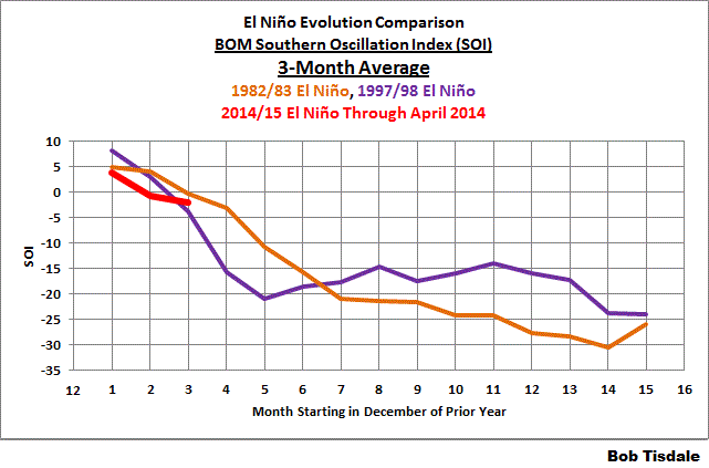
Figure 4
# # # # # #

Figure 5
But that still doesn’t help us with the fact that the reference points for the Southern Oscillation Index are off the equator while El Niño events are focused along the equator in the Pacific. Thus…
NOAA’S EQUATORIAL SOUTHERN OSCILLATION INDEX
In their Climate Prediction Center Equatorial Southern Oscillation Index (1949-present) webpage, NOAA describes the dataset as:
Abstract:
This is one of the CPC’s Monthly Atmospheric and SST Indices. It contains Equatorial Southern Oscillation Index (standardized sea level pressure differences between EPAC (5N-5S, 80W-130W) and INDO (5N-5S, 90E-140E)) for the period of 1949-present. The anomalies are departures from the 1981-2010 base period means.
Purpose:
This index is constructed for applications in climate monitoring, climate analysis and verifications of numerical models.
Please refer to Figure 1 again for the locations of the EPAC and INDO regions. Because they are comparatively large regions, they should be less susceptible to weather noise, and because they are located along the equator, they should better capture the equatorial trade winds. The Equatorial Southern Oscillation Index is calculated in a similar fashion. It represents the sea level pressure difference between the eastern equatorial Pacific (EPAC) and the sea level pressure of equatorial Indonesia (INDO)…with INDO subtracted from EPAC.
The Equatorial Southern Oscillation Index data are available from the NOAA Monthly Atmospheric & SST Indices webpage. The Indonesia (INDO) sea level pressure data (standardized) are here, the Eastern Equatorial Pacific (EPAC) sea level pressure data (standardized) are here, and the Equatorial Southern Oscillation Index data are here (and it appears the difference is then standardized as well.) NOAA also provides the Equatorial Southern Oscillation Index data as a 3-month running mean here. But there really doesn’t appear to be the same need to smooth the Equatorial Southern Oscillation Index data, as you shall see.
Figure 6 compares the Equatorial Southern Oscillation Index values so far this year to the values during the development of the 1982/83 and 1997/98 El Niño. The evolution this year falls in line with the two strong El Niños.

Figure 6
Compared to the other El Niño evolutions, Figure 7, this year appears to be the stronger (more negative) than normal at this stage.

Figure 7
And for those who would like to see the comparisons with the Equatorial Southern Oscillation Index data smoothed with the 3-month running means see Figures 8 and 9.

Figure 8
# # # # # #

Figure 9
COMPARISON OF THE TWO SOUTHERN OSCILLATION INDICES
Figure 10 compares the BOM Southern Oscillation Index data to the NOAA Equatorial Southern Oscillation Index data. The BOM also multiplies their SOI data by 10 after standardizing it, so for the comparison I scaled it back by dividing their data by that factor. The correlation between the two indices is not as good as one might suspect, with a correlation coefficient of 0.77.

Figure 10
And NOAA’s Equatorial Southern Oscillation Index data correlates better (-0.83) with NINO3.4 sea surface temperature anomalies (Kaplan SST) than does the BOM Equatorial Southern Oscillation Index data (-0.71).
CLOSING
The Southern Oscillation Index from BOM has been around for a long time. It is a commonly used ENSO index. It is noisy and, at times, does not appear to reflect what’s taking place along the equatorial Pacific. Then again, it is much studied with respect to its impact on weather in Australia and New Zealand.
It appears that NOAA’s Equatorial Southern Oscillation Index better reflects what’s taking place along the equator in the Pacific, where ENSO events take place, but it is not as popular as the BOM SOI.
EARLIER POSTS IN THIS SERIES
- The 2014/15 El Niño – Part 1 – The Initial Processes of the El Niño.
- The 2014/15 El Niño – Part 2 – The Alarmist Misinformation (BS) Begins
- The 2014/15 El Niño – Part 3 – Early Evolution – Comparison with 1982/83 & 1997/98 El Niño Events
- The 2014/15 El Niño – Part 4 – Early Evolution – Comparison with Other Satellite-Era El Niños
- The 2014/15 El Niño – Part 5 – The Relationship Between the PDO and ENSO
- The 2014/15 El Niño – Part 6 – What’s All The Hubbub About?…
- The 2014/15 El Niño – Part 7 – May 2014 Update and What Should Happen Next
And for additional introductory discussions of El Niño processes see:
- An Illustrated Introduction to the Basic Processes that Drive El Niño and La Niña Events
- El Niño and La Niña Basics: Introduction to the Pacific Trade Winds
- La Niñas Do NOT Suck Heat from the Atmosphere
- ENSO Basics: Westerly Wind Bursts Initiate an El Niño
FURTHER READING
My ebook Who Turned on the Heat? goes into a tremendous amount of detail to explain El Niño and La Niña processes and the long-term aftereffects of strong El Niño events. Who Turned on the Heat? weighs in at a whopping 550+ pages, about 110,000+ words. It contains somewhere in the neighborhood of 380 color illustrations. In pdf form, it’s about 23MB. It includes links to more than a dozen animations, which allow the reader to view ENSO processes and the interactions between variables.
I’ve lowered the price of Who Turned on the Heat? from U.S.$8.00 to U.S.$5.00. A free preview in pdf format is here. The preview includes the Table of Contents, the Introduction, the first half of section 1 (which was provided complete in the post here), a discussion of the cover, and the Closing. Take a run through the Table of Contents. It is a very-detailed and well-illustrated book—using data from the real world, not models of a virtual world. Who Turned on the Heat? is only available in pdf format…and will only be available in that format. Click here to purchase a copy. Thanks. Book sales and tips will hopefully allow me to return to blogging full-time once again.
We keep calling the movement of water to be a Kelvin wave.
I don’t think that is really what is going on. It is a convenient moniker, but it is really a loop of two different ocean currents. One at the surface that normally flows east-to-west; and an undercurrent at 150 metres depth that is almost always flowing west-to-east (at roughly the same speed at the surface current). It is a circulating pattern (18,000 kms long in width but 36,000 kms long for a complete loop). Parts of the loop can vary between +/- 5.0C from what they normally would be. And then other impacts occur as different parts of that +/- 5.0C are at the surface versus in the depth.
Eric Worrall says: “I live in Hervey Bay, on the East coast of Australia. The last week or so has been cold and set – unusual weather for a subtropical region, and not what you would expect if the surface waters of our end of the Pacific were heating up.
Wouldn’t be surprised if this El Nino were a fizzle.”
Eric, we had a blast of Antarctic air cool things off. It’s kinda hard to feel the ocean heat when you’re getting blasted with polar air. While it is a bit unusual in this part of the world, it isn’t unheard of.
I think you’re right that the much anticipated El Nino will fizzle… but failed predictions are soon forgotten, and I’m sure they’ll be back next year with new predictions and updated graphs.
I need to decide this week to sell almost all of my cows, or only half. Big $ (for me) and long term consequences follow from the decision. It would be nice if the powers that be worried a little more about the weather in the next 6 to 12 months and less about the weather in 60 to 120 years.
So is it El Nino and drought or La Nina and a good season ahead for eastern Australia?
Bill Illis says: “One at the surface that normally flows east-to-west; and an undercurrent at 150 metres depth that is almost always flowing west-to-east (at roughly the same speed at the surface current).”
There’s also the equatorial counter current, a surface current.
Maybe it’s easier to think of an equatorial Kelvin wave as pulse along the equatorial undercurrent.
Plain Jane,
If it is possible to do, follow the advice of stock market advisers to someone with a large amount of money to invest. They might suggest using 10% of the money each month to buy or sell. If during the first few months the market drops like a rock in a still pond, buy more aggressively. If it goes up like a shooting star, don’t buy, but maybe sell. Selling physical assets is a local thing (including the positive or negative weather forecasts) and more problematic than clicking the sell-box on a computer screen. Good luck with the weather and your decisions.
It is definitely appalling to see the vast number of individuals here who are somehow trying to convince themselves of no el nino this year (or a weaker one) despite much of the evidence to the contrary.
Bob, that NE extratropical North Pacific warm pool combined with a slight to strong El Nino that is still in place when Winter is upon us again leads to moisture being picked up and brought to shore which then falls as tons and tons of snow in the mountains. Could this be similar to what happened in the mid-1990’s when tons of overabundant snowpack melted in warm Spring downpours and all our Oregon rivers over-flowed their banks, spilling into downtown Portland and wiping out beef and dairy herds in Tillamook? That event was a real budget buster and worse. People as well as animals lost their lives in it.
Well, I’m not so much into the prediction aspect of things as I am the observation. El Nino and La Nina are, as far as I am concerned, artifacts of trade wind conditions. Winds in the western portion of the equatorial Pacific are picking up after having slackened and even reversed for a bit. Same in the Eastern portion. They are still a bit slack in the central region around the dateline, though.
http://www.pmel.noaa.gov/tao/jsdisplay/plots/gif/sst_wind_anom_5day_jsd.gif
Heat content seems to be generally declining from what it was in April.
http://www.cpc.ncep.noaa.gov/products/intraseasonal/tlon_heat.gif
http://www.cpc.ncep.noaa.gov/products/analysis_monitoring/enso_update/heat-last-year.gif
It LOOKS to me like a continued La Nada condition only on the warmish side of zero for a while after having been on the coolish side.
I’m also not detecting any change yet to a more zonal flow of the jet in the eastern Pacific along the US west coast. It still looks like a meridional flow with the “pineapple express” still headed from Hawaii up into British Columbia and Alaska and that seems so far to be typical of this “La Nada” condition.
Pamela,
RE: February 1996 rain on snow event
Here is the case study (Sept. ’06) of the storm you mention :
http://water.usgs.gov/nrp/proj.bib/Publications/2007/mccabe_clark_etal_2007.pdf
Their highlighted introduction says “Severity of rain on snow depends on a number of factors, and an overall decrease in these events appears to be driven, in part, by changes in El Niño–Southern Oscillation.”
I have no idea what that means and did not read enough to find out.
John, here is a pretty well done and quick read on conditions back then. There were connections to the tropical MJO. Interesting stuff.
http://www.cpc.ncep.noaa.gov/products/assessments/assess_96/pacnw.html
ERic Webb, what evidence to the contrary? You’ve been beating this super duper el nino for months. Nothing you’ve predicted has come true so far. April was a big bust. You’ve been worse than the worst alarmists this year when it comes to this. I finally tuned you out because your forecasts were worthless. After April’s fizzle, I thought about going back and throwing it in your face but decided against it. You’re just a kid, I thought. Kids always think they know more than they do.
The only “evidence” of a strong el nino at all was the kelvin wave. Even that is now fizzling out. All other factors show weak to moderate el nino. An April-May-June el nino is basically off the table now, given the current strength of the trade winds this week so far a May-June-July el nino is becoming increasing unlikely too. A June-July-August el nino, which this one is looking more and more like by the day, is traditionally a moderate one. The strength of this el nino is no where as strong as it was in 1997, that’s a fact. You’re going to need more than ONE strong kelvin wave to create a super el nino.
I warmed you once not to invest your entire prediction on the kelvin wave alone. You chose to be a little idiot and insult me. Now i’m the one laughing at you and your weather “expertise.”
Bob, Interesting review again, as usual from you. In reading many of the comments I get a bit frustrated as some of the folks really don’t understand WEATHER in the South Pacific. While Trenberth doesn’t seem popular here he really is an outstanding Tropical Forecaster with texts published on the subject. His comments on the SOI and MJO are spot on and there much more that affect the index as he indicates. I think what is confusing for some of the commenters is the use of anomalies instead of looking at real data. As I have mentioned in numerous comments, I do this every day when I forecast. While the MJO is cyclic and certainly skews the SOI so do the traveling Anticyclones which affect the SOI even more. When an intra-anticyclonic trough is over Tahiti and an Anticyclone is near Australia the index anomaly would be negative (pressure lower in Tahiti, higher in Darwin), but the reality is the WINDS still blow east to west. The only time we see west to east is during an MJO or the North side of a traveling Depression. The later occurs nearly every 7 to 10 days, but the northern extent of these winds usually doesn’t go north of 15 to 20S. The MJO is most active in the Austral summer (eg Dec, Jan, Feb) and weak in the Austral winter, which is now. So the chance of a big ‘westerly wind burst’ along the equator at this point is pretty slim.
The other item that seems to be confusing folks is the talk of equatorial trades. There are really no equatorial trades to speak of. This area is the Doldrums or Horse Latitudes (named because being an area of no wind ships of old had to toss the horses overboard because there wasn’t enough water). To confuse even more there are two equators. The geographic one and the meteorological one. The later is the ITCZ which changes latitude; mostly north of the geographic one east of the dateline but can go south of the geographic one west of the dateline. The ITCZ is fed by NE winds on one side and SE winds on the other, in the main. The meteorological ITCZ east of the dateline corresponds to the ‘equatorial counter current’.
As many have noted the ‘Null School’ site is a good one to see streamlines . It’s then that you’ll get the idea of watts up with the wind and how much it affects ENSO.
And lastly I too recommend your book, it’s worth it folks.
Since 2004, satellites recorded a significant increase ozone in the middle stratosphere in the tropics compared to the long-term average. This can cause changes in circulation over the equator.
http://www.cpc.ncep.noaa.gov/products/stratosphere/strat-trop/gif_files/time_pres_TEMP_ANOM_AMJ_EQ_2014.gif
Jack, you just prove my point in trying to convince yourself of what’s going on here & are simply letting your AGW views skew your view on this upcoming El Nino event. It’s also ironic you mention that I’m a “kid”, yet your rant above reveals your maturity level is equatable to that of a child. Let’s just remember that you & many others here didn’t even think an el nino was coming to begin with several months ago, but that has clearly changed, and to say that AMJ is off the table is somewhat delusional on your part as you have once again failed to look @ur momisugly any actual data of the ENSO regions, you’d be able to see that we’re virtually @ur momisugly .5C marker now, & the AMJ period is a tri-monthly average, so the fact that we are almost to that point in the beginning of the 2nd month bodes well AMJ starting point. In addition, the SOI is as Bob has stated above is among the nosiest ENSO indicators & although it isn’t common for us to see positive spikes like this in Apr, it’s not entirely unheard of as both the 1957-58 & 1986-87 El Nino events, strong & moderate respectively in intensity, observed a +SOI spike in Apr following -SOI bursts earlier in the year. If anything, is “fizzling” its the easterly trade winds, which with the passage of each successive MJO pulse, have been decaying in the Pacific, especially in the regions east of the international dateline.
http://www.cpc.ncep.noaa.gov/products/analysis_monitoring/enso_update/u850_c.gif
The first Kelvin Wave was historic and has completely altered the base state of the Pacific to the point that even when the periodic WWBs in the wake of the mean convective signal associated with the MJO start to decay, you’re still going to end up with mean westerly surface currents. Also, the warm upwelled water has kick-started the classic Bjerknes Feedback process, & as result, the MJO is starting to become biased towards the Pacific & Western Hemisphere (Phases 7-1) and TRMM rainfall anomalies reveal that an El Nino like precipitation pattern has already evolved in the tropics with a wavenumber 2 precip pattern featuring drier conditions over the Maritime Continent & Tropical Atlantic with 2 regions of opposing wetter than normal conditions & upward motion generally over the Pacific & African Sahel.
http://trmm.gsfc.nasa.gov/trmm_rain/Events/new_anomaly.gif
Eric, that’s the same argument you’ve been making for months. The only reason someone would not accept that there is some record-breaking el nino brewing, according to you, is because they are so biased against AGW. I think you’re projecting all the way. It’s YOU who arrogantly doesn’t want to admit that you jumped the gun. You simply don’t want to admit you’re wrong.
I believe there will be an el nino, just like I always have. I just think it’ll be a moderate el nino, similar to 2002 or 2009. All the evidence, so far, shows exactly that. With every day this becomes more and more obvious. You’re just too immature to revise your original forecast.
To believe there will be an April-May-June el nino now is ridiculous. With the winds picking up strong again now, it looks unlikely that an el nino will form until the end of May at the earliest. There was no el nino in April. Yet, somehow, you believe we’re still on course for an April-May-June. Right. The kind of A-M-J that begins at the end of May or beginning of June.
You’re the one who sees what you want to see.
Thanks Pamela,
I’m going to try spraying some weeds while the wind isn’t blowing 40 mph, so will read that this evening. I am an unpaid volunteer trail worker with Washington Trails Association (WTA.org) and the massive runoffs provide job security with the need for bridge replacements and trail relocations.
Weatherdave, I wouldn’t say that, the MJO actually peaks in amplitude much later in the northern hemisphere winter, towards March, & since the Pacific SST gradient is weakest in the MAM tri-monthly period, that is consequently the time of greatest change in the ENSO index, this also means the Pacific is most susceptible to impacts from WWBs, Rossby waves, etc. as a repercussion of the coupled sea surface-atmospheric temperature & pressure asymmetry being weakest in this time of the year. In addition to favorable SST gradient. the ITCZ is relatively symmetric about the equator, which also means that this period is when WWB, Mixed Rossby-Gravity (MRG) waves that can lead to the genesis of W Pacific TCs & Rossby waves, etc. have the largest implications on the formation of Equatorially-trapped Kelvin Waves that can lead to El Nino. Thus, the claim that WWBs later in the spring will somehow have significantly less impact than those earlier in the year isn’t necessarily valid.
Eric, You need to check those trade winds again and the SOI.
May 7th -18.52
May 8th -12.08
May 9th +04.77
May 10th +13.81
May 11th +23.61
See a pattern?
All you ever had was the kelvin wave. Even with the kelvin wave surfacing, the eastern pacific is still colder than 1997. The 3+4 is still stuck in neutral, literally. The trades are strong again, so I don’t see that changing this week. So good luck with your A-M-J.
@ur momisugly Jack
You’re obviously grasping @ur momisugly straws as my initial “forecast” hasn’t changed in several months & still remains for a 2.0-2.3C for the peak ONI, clearly “challenging” (not necessarily passing) the El Ninos of 1997-98 & 1982-83, along the lines of 1965-66 & 1972-73 El Ninos, which is a very far cry from what you were promoting months ago w/ ideas of no el nino and there isn’t any substantial evidence of a modiki (central Pacific) El nino, like the 2002-03 & 2009-10 El Ninos, but I digress. AMJ is a tri-monthly average (yes, that means from the beginning of April to the end of June), & if that average reaches or exceeds .5C, we have the AMJ starting period for El Nino, not a difficult concept to grasp. & Yes we are still on course for this, perhaps if you actually attempted to look @ur momisugly any of the wind, ENSO, or CCKW data, it would be very easy to see we are virtually @ur momisugly the El Nino threshold now & the easterly trades have been weakening dramatically over the last several months…
Weather Dave says:
May 11, 2014 at 11:19 am
“. . . The other item that seems to be confusing folks is the talk of equatorial trades. There are really no equatorial trades to speak of. This area is the Doldrums or Horse Latitudes (named because being an area of no wind ships of old had to toss the horses overboard because there wasn’t enough water). ”
The Horse Latitudes and the Doldrums are not the same. Today the terms are respectively SubTropical High Pressure (STHP) and Intertropical Covergence Zone (ITCZ). The latter is the one mentioned in Coleridge’s “Rime of the Ancient Mariner.”
Now to the naming of the Horse Latitudes: I wrote the following to a friend sometime back and hope we are far enough along in this thread that the Boss and Bob T. won’t mind me adding it here; it is a bit long:
To a friend:
Here is the long story about how I got to the site mentioning the compression of cotton bales (aka cotton-screwing) and the chants by which the timing of turns on the jack-screws was done.
I have taken and read many historical things, and included are history of science and history of geography. From the history of science side comes the fact that when Galileo investigated the force of gravity by timing a ball rolling down an inclined plane – clocks accurate enough to do this had not been invented.
Answer is here:
http://www.mcm.edu/academic/galileo/ars/arshtml/mathofmotion1.html
Any geography book that mentioned the “Horse Latitudes” usually explained the name using a story about sailing ships getting caught in calm areas and then throwing horses overboard to save water for the humans. One text gave a second account, namely that the English word “horse” can be a verb in the sense one might have “to horse” something heavy this way of that way by pushing or tugging on it. Becalmed sailing ships could be “horsed” from a calm area to one more breezy by tugging on it from a rowed boat. That sounds fun.
The book, wherein this was, finished by saying the world might never know which of these explanations was the truth. Along about the 40th year of teaching classes that include explaining the horse latitudes, I explained the 2 possible explanations for the term. A non-traditional student (somewhat older and more experienced than the average freshmen) offered that he could suggest a third explanation. He did, and the next class meeting he brought a thick book on sailing ships, rigging, stories, and work songs or shanties (also chanteys).
So now there are 3 explanations and not much guidance for selecting one over the others.
Over the years I’ve thought of this and wondered. In no particular order here are some thoughts.
Most maps of the route Columbus took to “America” are useless – wrong projections or just simple cartoons. In any case, the 3 ships started and headed more south than west – Columbus did not attempt to sail “west to America.” Had he gone west he would have sailed directly into the high pressure zone. He had to know that it was there! How?
Apparently, he knew this by talking to or sailing with people that already knew about the Atlantic Ocean:
http://en.wikipedia.org/wiki/Grand_Banks#History
Then there is the idea that Spanish ship captains ordered horses thrown overboard. The two problems are: 1. There is at least one classic painting (I’ve seen a photo, WSJ, about 10 years ago) of the unloading of horses when arriving in the New World. It is a great painting of a beautiful horse, rearing, as he is led to an opening in the rail and invited to leap into the sea. Without wharf or quay the unloading is accomplished in deep enough water to accommodate a plunging horse. It would be easy to make up a story about this if one did not know what was happening. 2. Back to the name: We don’t call these places the Caballo Latitudes or Yegua, or é gua (or a gender neutral noun). Maybe that’s because the Spanish did not find such places of interest and knew enough to stay out of them.
Well, I think the English sailors knew that too. Would sailors repeatedly go into an area of calm seas, find themselves becalmed, and then “horse” their way out with oars and a line. Not likely. If they did would they return to port and brag about it? Not likely.
English history tells of ships about to leave and needing sailors. It is romanticism to believe that lots of folks wanted to leave and maybe not come back. The word “nap” with the word “kid” in front suggests one way of getting sailors. But napping also involved going to pubs and hauling off passed-out men – as long as the ship’s representatives paid the drunk’s bar bill. This cost was called a “horse” or “dead horse.” Another source of “horse” in this sense was a purse given to the wife and family of a man about to go to sea – this would be about one month’s wages.
Ships would sail south from England and many of the men were paid ahead in the sense of the above paragraph. After a few weeks of sailing this pre-payment (“the horse”) would have been taken care of by their work – following which they would be given credit until a port was reached or they returned to England and were paid after the sale of the acquired cargo.
Into the voyage, at the point where the horse had been paid a straw (wicker) horse would be raised and swung over the rail. The celebration would reach its apex as the line was cut and the representation of “the horse” was sent drifting in the sea. Someplace I have some material on this with a line drawing of the ceremony but most folks have concentrated on the words and the timing of the chants and the fact that having everyone pull at the exact same instant could be achieved with this simple method.
Until, shown a better alternative explanation I favor the shanty and the floating straw form as the source of the term Horse Latitudes.
In class, I would tell students that the characteristics of these calm areas should be the things to remember and if floating dead horses helped them – all was good.
@ur momisugly Jack
You’ve purposely cherry-picked the last 5 days of SOI data to prove baseless point, & it doesn’t take an “expert” to understand that the SOI doesn’t necessarily fully represent the actual trade winds in the Pacific, & it is a rather noisy index, prone to local wx variability such as the MJO which has pushed back into the eastern hemisphere, with what appears to be a wavenumber 2 pattern in convection over the global tropics. http://www.atmos.albany.edu/student/ventrice/real_time/maps/velocity_pot/anom/28.gif
@ur momisugly Jack
The trade winds undergo week-week variability in intensity, however, when looking @ur momisugly ENSO it is better to observe the overall trend, & in the last few months, the trend clearly indicates substantial weakening that favors a rapid start to El Nino
http://www.cpc.ncep.noaa.gov/products/analysis_monitoring/enso_update/u850_c.gif
In addition, the evident flattening of the thermocline & eastward propagation of the 28C isotherm is a clear indicator that El Nino is upon us http://www.cpc.ncep.noaa.gov/products/analysis_monitoring/ocean/anim/wkxzteq_all.gif
@Peter M NZ:
May 11, 2014 at 2:55 am
https://www.niwa.co.nz/climate/sco/seasonal-climate-outlook-may-july-2014
Lets see how it goes
Eric, I never predicted that there wouldn’t be an el nino. You need to stop living in your bubble. I said there would be a weak one. The problem with you is that you project. This way you can just dismiss anything that doesn’t conform to your belief. It allows you to remain morally superior. Adjusting your beliefs becomes unnecessary this way, because you are always right and when someone disagrees with you than it is because they are biased or there is a flaw in their thinking. This is not a sign of brilliance, it’s a sign of immaturity.
June-July-August (1.3 to 1.6 C) and it lasts 9 to 11 months, my guess. 2.0 to 2.3 C is ridiculous, in my opinion. Nothing exists which would justify that. One strong kelvin wave won’t do that. The problem with you is you don’t want to admit you’re wrong.
To John F. Hultquist.
You certainly study your history. You may have missed my point though. When I say there are ‘no trade winds’ at the equator I’m referring to the meteorological equator otherwise known as the Equatorial Trough. In the Pacific it lies north of the geographic Equator in July, but in January it tends to drop south of the geographic equator near the dateline, through the Solomons and across the top of Australia after which it veers to the NW and heads back to 0 degrees latitude. Back to the point, graphs from whomever who discuss anomalies of the equatorial trades are misleading. Zero degrees latitude from the dateline eastward have winds almost always from an easterly quadrant (sometimes SE, sometimes E sometimes NE from the northern hemisphere). These winds are generally from either the travelling Anticylones centered near 30S and or from the Semi-permanent Anticyclone off the coast of South America. To make things even more difficult for us Tropical forecasters are the event of double Equatorial Troughs. These occur during the transition seasons and tend to have westerly winds between them. I am looking at one of my archive charts which show a double ET at 10n and 10S and east of 140E. This condition does not last long, certainly not long enough to create a big push for ENSO. But my main point is that if you study actual wind flow west of the equator winds are almost always from an easterly quadrant and when anomalies are discussed someone can get the impression that this isn’t the case.
To Eric Webb.
Boy, you are throwing in a lot of data which I think will confuse a lot of people. First of all an Equatorial Rossby Wave is an ATMOSPHERIC WAVE not Oceanic. It’s a twin circular wave that travels westward. Picture a twin High next to a twin Low next to a twin High, etc. (eg the twin High has a High north of the equator and one south of the equator etc) The wind circulation of the Highs clashes with the circulation of the Lows and create a convective area at the geographic equator. This wave travels WEST bringing with it the convective areas.
The MRG is a ‘Mixed Rossby-Gravity Wave’. It looks like this: Picture a series of a circular mass of air straddleing the equator. Within each Mass there is a High to the north with a low to the south on one mass. The next mass is reversed, the High is to the south and the Low to the north. The two flows clash at the equator causing convection. The Wave moves WEST.
Both of these waves will encourage La Nina
Your comments on the MJO are curious. I can assure you in the Pacific the MJO peaks in the AUSTRAL Summer or Dec, Jan, Feb. The ‘wave’ or area of convective activity is clearly evident on satellite imagery and the area that has the main affect in the Pacific is south of 0 latitude down to 15 or 20 South. It originates in the Indian Ocean and if it intensifies near the Solomons it activates the SPCZ and can be a major factor in TC development. But more often it just brings convective activity, sometimes very heavy, and westerly winds. Once it passes the dateline it diminishes rapidly on satellite imagery and southeasterlies return.