After battling the “dry” tropical air along its route from Haiti, Cuba, Florida, to Louisiana, Isaac has finally become a hurricane with the required 64+ knots 1-minute sustained near-surface winds. Numerical models finally expressed some certainty on a Louisiana coastal landfall, but diverged significantly on intensity. There is also some question about the ability of Isaac to penetrate far inland away from the frictionally convergent swamps. A major flood event is underway.
 Click image to animate it over several hours
This tracking map is in high definition (updates every 3-4 hours, click to enlarge)
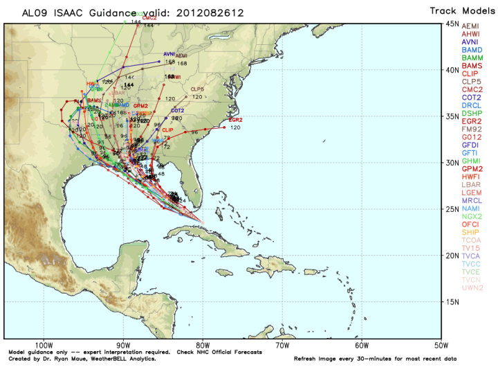
Now WeatherBell’s track map via Ryan Maue: (click to enlarge)
NHC:
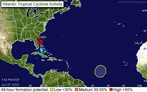
Track map in HiDef – click to enlarge:
More…plus signup for free hurricane bulletins.
http://wattsupwiththat.com/reference-pages/tropical-cyclone/
Oh the horrors of “Tropical Storm” Isaac, it is going to get really bad anytime now I have been hearing for two days. LMAO about the absolutely worthless computer models saying it is going to be a cat 1, 2 and even a 3 ….anytime now. Lets all keep supporting government flood and disaster insurance so people have no reason to stop living in moronic areas below sea level. Markets deal with this nonsense very easily, feel free to live there but – at your own risk.
Why are people linking to hurricane alarmist Judith Curry? Do I really care about someone who believes, “Gore’s statement in the movie is that we can expect more storms like Katrina in a greenhouse-warmed world. I would agree with this” – Judith Curry, 2006
or..
“We’re looking at a much worse [Hurricane] risk than people were thinking about a year ago …some places are going to become uninsurable.” – Judith Curry, 2006
…not with socialized insurance! No disaster is too expensive to rebuild from! I take it she understands economics about as well as hurricanes. I have never seen so many people desperately wanting this to be like Katrina.
Presently, Isaac has been called a hurricane for several days, but has not been a hurricane. We are seeing hype in thne media again, as with Irene. And, as with Irene, Isaac possibly could fail to be a hurricane at landfall, by the proper definition. Could a Watts Up post be set up devoted to assessing the strength of Isaac at landfall, and how long Isaac survives as a hurricane, if Isaac does become a hurricane, and also to post examples of hypoerbole?
This was helpful with seeing how the media failed to evaluate Irene and failed to cover Irene accurately – as an example, the Susquehanna River in NY and PA has flooded a ocuple times in the recent couple of decades, from Irene’s aftermath and also from non-hurricane rains; this shows that Al Gore’s Hurripocalypse may not be as unique in creating bad weather as he might want us to think.
How embarrassing, the weather channel is now apologizing for constantly calling “Tropical Storm” Isaac a “Hurricane”, what a joke. This is pathetic every time it goes up in wind speed 1 MPH they report it like it is jumping categories.
I wonder did the residents of New Orleans pay for the 14 billion dollar levy system themselves or did my federal tax dollars get wasted so people can choose to live in moronic locations?
Ooooh, hurricane expert Obama is giving a press conference on how they are ready to respond to “Tropical Storm” Isaac.
I have a simple solution for New Orleans, make an ordnance that every resident has to pass a swimming test or must buy a life jacket, then when the levies breaks they can swim or float out of the city and we don’t waste money with helicopter rescues for people who do not understand what evacuate means. Even if you are poor you can buy an innertube for less than $5 and float our of the city as if it was a day at the water park.
David L. Hagen says:
August 27, 2012 at 8:16 pm
Curry compares the accuracy of CFAN vs the national hurricane forecast for Isaac.
=============
Perhaps governments should get out of the forecasting business and contract private industry to provide the service. Pay for forecast accuracy, not hype.
Overnight this single change would clean up much of the climate industry, which relies on doom and gloom forecasts to generate ever increasing grants, with no accountability for accuracy.
bearpawsweather is a great aggregate site for tropical storm tracking, info.
Tom in Worc.(usa) says:
August 27, 2012 at 8:53 pm
How many times are we going to rebuild a city that is in a hurricane zone and is below sea level?
============
Galveston rebuilt the city 15 feet higher when it was leveled 100+ years ago. Apparently the technology to fill in the low lying areas in New Orleans has been lost over time.
Central pressure coming in at 976 mb. Don’t think I have ever seen a tropical storm with that low of a pressure. That is usually low enough for a cat 2.
I think the hurricane center is doing a good job in waiting for the winds to pick up before calling Isaac a hurricane, even though they have been expecting it since the Florida Keys.
Latest Vortex data message has a flight level wind of 84 kts. That may tip their hand in making Isaac hurricane with the next advisory coming out in 20 minutes.
Regardless, the large wind field and slow movement will do the damage in creating a lot of coastal flooding and beach erosion. It won’t be the end of the world, but it will be nasty. Biggest threat to most folks will be the 10-15 inches of rain that falls over Southern Louisiana the next 3 days. That’s a lot of water!
And what does Dear Leader do as Tropical Fizzle Isaac approaches? He goes on a fund raising trip!!!!
This just in…
“REPORTS FROM AIR FORCE AND NOAA HURRICANE HUNTER AIRCRAFT INDICATE
THE CENTRAL PRESSURE HAS DECREASED TO ABOUT 976 MB SINCE THE
PREVIOUS ADVISORY…BUT IT HAS LEVELED OFF OVER THE PAST FEW HOURS.
THE MAXIMUM 850 MB FLIGHT-LEVEL WIND OBSERVED HAS BEEN 89 KT…
WHICH EQUATES TO A SURFACE WIND OF ABOUT 71 KT. HOWEVER…
BIAS-ADJUSTED SFMR SURFACE WINDS HAVE ONLY BEEN AROUND 60-62 KT…
WHICH CORRELATES WELL WITH DROPSONDE BOUNDARY LAYER-DERIVED SURFACE
WINDS. AS SUCH…THE INTENSITY OF ISAAC IS BEING MAINTAINED AT 60
KT…WHICH IS JUST BELOW HURRICANE STATUS.”
I like that they are keeping it a tropical storm for now. They could have have made it a hurricane based on the upper-level winds, reasoning that surface winds have reached hurricane strength somewhere and that they just haven’t found them yet. They have done it in the past, but not this time.
Good for them!
I hope Isaac isn’t too mean to the coast and then he decides to come up and visit the entire state of Missouri. We really could use whatever rain he has left. I know your tracks have him turning right, but I sure hope he doesn’t.
I caught a snippet of Weather Channel this morning, and they seem perplexed as to how Isaac can have such strong winds aloft, but not have those winds spiraling down to the surface to make him a hurricane. I don’t care. Let those winds stay aloft. I think most everyone on the ground would appreciate that.
Dennis maybe (a Category 3 hurricane that summer)?
List of storms in the 2005 Atlantic hurricane season
http://en.wikipedia.org/wiki/List_of_storms_in_the_2005_Atlantic_hurricane_season
Hurricane Dennis
http://en.wikipedia.org/wiki/Hurricane_Dennis
.
Hoping for a BAMS track here!
Please Please head north to Arkansas and the heartland – so dry! Sorry, gulf coast if you get hammered on the way by.
Good example of confilicting needs and problems…….
Interesting range on those models, from Oklahoma to alabama
Isaac will be a flop, what kind of name is that for a hurricane?
Just upgraded to hurricane (update banner at top):
http://www.foxnews.com/weather/2012/08/28/isaac-likely-to-become-hurricane-takes-aim-at-new-orleans/
ferdberple
August 28, 2012 at 7:38 am
Tom in Worc.(usa) says:
August 27, 2012 at 8:53 pm
How many times are we going to rebuild a city that is in a hurricane zone and is below sea level?
============
Galveston rebuilt the city 15 feet higher when it was leveled 100+ years ago. Apparently the technology to fill in the low lying areas in New Orleans has been lost over time.
###
New Orleans is sinking and has been for quit a while. Not much to be done about that but move, though it is pretty hard to move history.
If it is not too late to join in the wind speed definition discussion, we in the UK have been treated by the BBC to a forecast of landfall speeds of 175 Kilometres per hour.
For those of you in the USA having trouble with the definition in Knots, I am pleased to be able to tell you that a Kilometre is five eighths of a mile and is the preferred unit of measurement for all European warmists, and flies in the face of the UK unit of distance which despite the prolonged efforts of eurofascists remains as imperial miles.
Thus agendas are cynically promoted by an organisation whose World Service broadcasts were once the respected voice of truth for citizens of countries where propaganda was the norm.
What price the BBC now?
Looking at the center of the storm on radar. Worst place to be and worst direction to be arriving from for New Orleans. I may have to eat my words that this is a Ho-Hum storm. It depends on how high the actual storm surge is and if it arrives at high tide.
Merrick says:
August 28, 2012 at 5:29 am
Does anyone know where I can collect all of the 4 hour updates to the NOAA NHC Track Map since Issac became a Tropical Storm? Thanks…
Did you miss the past forecast links at http://www.nhc.noaa.gov/ ?
Look for the line that says “Hurricane ISAAC | RSS Feed icon | NESDIS Satellite | NDBC Obs | Storm Archive” Then click on “Storm Archive”. Then click on “Graphics Archive”. That will take you to http://www.nhc.noaa.gov/archive/2012/ISAAC_graphics.shtml which has animations of their graphics. I’m not sure how you get the individual frames, but if you wanted them to create an animation, that’s been done already.
That’s interesting. The initial report for 11:00 AM was 70 mph sustained winds and gusts to 85. Now the 11 AM report has been changed to 75 sustained & 85 gusts. Guess they are trying to keep people from being complacent. Or maybe they just have to call this hurricane Isaac no mater what.
The wind is from the North-Northeast now, and it’s a hot wind. A bit more moisture than yesterday.
A local weather station is showing quite a drop in the barometer. Back in the day when we saw this it meant the storm was coming our way.
This is not my station, but it is near me. It’s in trees so the wind data is not so valuable.
http://weather.gladstonefamily.net/qchart/D1426
To roger:
“175 Kilometres per hour…” Really? The BBC really is going a little crazy. Converting to U.S. units, that’s close to 109 mph! The National Hurricane Center (NHC) projections are at 80 mph or below.
While it is certain that every American taxpayer (an endangered species) was levied for the New Orleans levees, it is also certain that levies and levees are quite different things. Words, even for scientists, do matter.