By Joseph D’Aleo, CCM, AMS Fellow, Weatherbell co-chief Meteorologist
This is August and the east coast season peaks in September with activity in October. August systems often provide just a hint at what is to follow. This year after the winter record cold and snows, spring heavy rains and record flood and tornadoes, a 60 to 100 year drought in Texas and nearby areas. A year without a summer in the Northwest and brutal heat in the south central and at times most other areas of the central and east. Now comes the hurricane season. La Ninas often do far more damage from El Ninos. This was a super La Nina, the second strongest in history (either behind 1917/18 if you use the atmospheric measure, 1955/56 if you use the other measures.
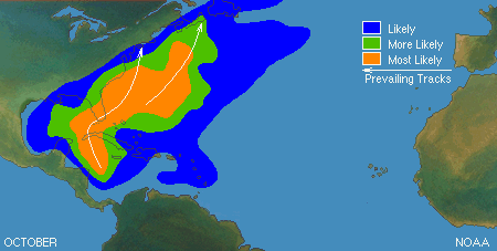
We have already had 5 named storms…nothing significant. But the season really doesn’t kick in most years until mid August. NWS NHC has upgraded their forecast for the hurricane season. Here is the normal hurricane tracks from August to October.


The warm Atlantic and cold Pacific usually mean an east coast landfall. The analogs and model forecasts suggests the trough which has been off the east coast moves inland far enough to threaten trouble for the east coast.
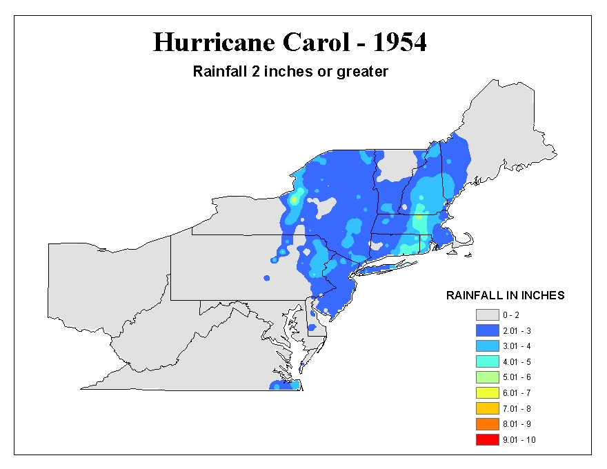
These troughs amplify than lift out leaving a weakness a storm in the waters off the east coast can penetrate. The Carolinas and the coast further north including New Jersey and New York are vulnerable. This region is is overdue. This summer was a lot like the 1954 and 1955 summers.

Carol, Edna and Hazel hit in 1954, Connie and Diane in 1955. Even New York City felt the storms effects though not a direct hit.
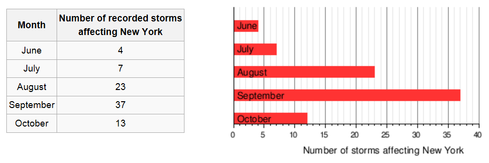
Historically, some storms have tracked that way.


I wrote on WeatherBell about the Hurricane of ‘38, Hurricane Carol in 1954 and the hurricane season of 1893. And covered the reasons why the northeast east coast and maybe NYC might be threatened this year.
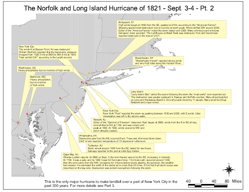
The worst storm recorded for the big apple was the Norfolk and Long Island storm of 1821.

It was estimated to be a category 3 or even 4 when it brushed New Jersey before making landfall on New York CIty 1930 UTC on September 3. This makes it the only major hurricane to directly hit the city since 1800. The late great weather historian David Ludlum summarized it below and enlarged PDF here.

The hurricane produced a storm surge of 13 feet (4 m) in only one hour at Battery Park. Manhattan Island was completely flooded to Canal Street. The flooding would have been much worse, had the hurricane not struck at low tide However, few deaths were reported in the city, since the flooding affected neighborhoods much less populated than today. Strong waves and winds blew many ships ashore along Long Island. One ship sank, killing 17 people.
Please come to WeatherBell and see the daily posts that Joe Bastardi and I provide all through the hurricane and winter seasons ahead. If you have energy, agriculture or retail interests, we provide special services to those markets.
Reference PDF’s:
1893 a hurricane season analog
Remembering Hurricane Carol in 1954
I hope Texans will understand that I’d like them struck by 2 or 3 Category 1 or 2 hurricanes very soon. For their own good, you understand
A hurricane is nature’s harsh answer to a drought in Texas.
Am I the only person wondering why one of these storms was given a name. It did not form any organised storm characteristics until 32 degrees north a full 10 degrees outside the tropics.
Unfortunately it will only take one good sized hurricane smacking squarely into the east coast anywhere from Virginia Beach to New York City to get the CAGW crowd and main stream media yelling again. On the lighter side, if a category 3 or higher hurricane does hit squarely into Ocean City, Maryland, the condominiums and hotels on the beach there might make really great fishing reefs.
“These troughs amplify than lift out leaving a weakness a storm in the waters off the east coast can penetrate.”
I presume that “than” should be “then”.
IanM
I am sorry I added the links on Icecap to the three stories on 1938, 1954 and 1893 after Anthony picked up the story.
See the Hurricane of ‘38 (http://icecap.us/images/uploads/The_September_Surprise.pdf) , Hurricane Carol in 1954 (http://icecap.us/images/uploads/Remembering_Hurricane_Carol_in_1954.pdf) and the hurricane season of 1893 (http://icecap.us/images/uploads/1893_a_hurricane_season_analog.pdf).
crosspatch says:
August 6, 2011 at 10:35 pm
Having spent a year here watching the politics of Delaware I assumed that you were just being more accurate calling it DemMarVa.
Quite a few years ago one of the Balt/Wash newspapers had an article about what might happen if a major Hurricane hit Ocean City, Md. A large part of the damage was cause by the storm surge spilling over into the bay behind the beach strip and then washing back out when the storm passed taking all of the debris and slamming it into to condo’s that line the beach area. That whole are is nothing but a sand bar and has grown considerably since the article was written. Not going to be pretty if(when) it happens.
Stephen Rasey
AMS issued a bulletin [Vol 79,NO (1998) called Effect of El Nino on Us Land Filling Hurricanes , Revisitsed . It found that no El Nino event has ever been associated with more than one major US hurricane but there is a 27 % chance for 2 or more major hurricanes during cold ENSO[La Nina ] phase and a 8 % chance during neutral phase. Seeing that this another neutral phase summer , consequently I think the probabilty of more hurricanes making US land fall is higher this year . [as many as 3 or more perhaps ] . However I dont think they will be of intense level [ level 2 or lower]
The overall hurricane season forecast looks about right[7-10 hurricanes ]
@Beth 6 August,
I think most everyone uses the MEI as the metric for ENSO.
It’s only August 9, but…never say never.
http://www.theglobeandmail.com/news/national/toronto/heavy-rain-leaves-cars-submerged-closes-roads-in-toronto-area/article2124078/
Toronto 1954.
http://www.ec.gc.ca/ouragans-hurricanes/default.asp?lang=En&n=5C4829A9-1