Is Al Gore at his Fisherman’s Wharf Condo? Our own Charles The Moderator sent me a query today, along with a link to this SFO Chron article about the possibility of snow down to sea level. It’s possible, and has happened before as shown by the photo below.

About an hour later, I got an email from my friend Jan Null, former lead forecaster for the NWS in SFO, who has put together a nice summary that I will share with everyone. First, the forecast: The forecast for Mount Tamalpais and other hilly areas of Marin County calls for snow:
 Click image for the current forecast.
But, for SFO City, no snow in the forecast, yet:
 Click image for the current forecast.
=================================================================
In his briefing, Jan Null writes:
To snow or not to snow, that is the question.
The weather pattern is certainly shaping up for a significant blast of Arctic air to invade California beginning Friday. The question being asked is whether the elements are in place for there to be snow all the way down to sea level around San Francisco Bay. The last time there was a significant covering of snow at sea level in the Bay Area was February 5, 1976.
See
http://ggweather.com/sf/snow.htm and http://thestormking.com/Sierra_Stories/San_Francisco_Snowstorms/san_francisco_snowstorms.html for this and other historic SF snow events..
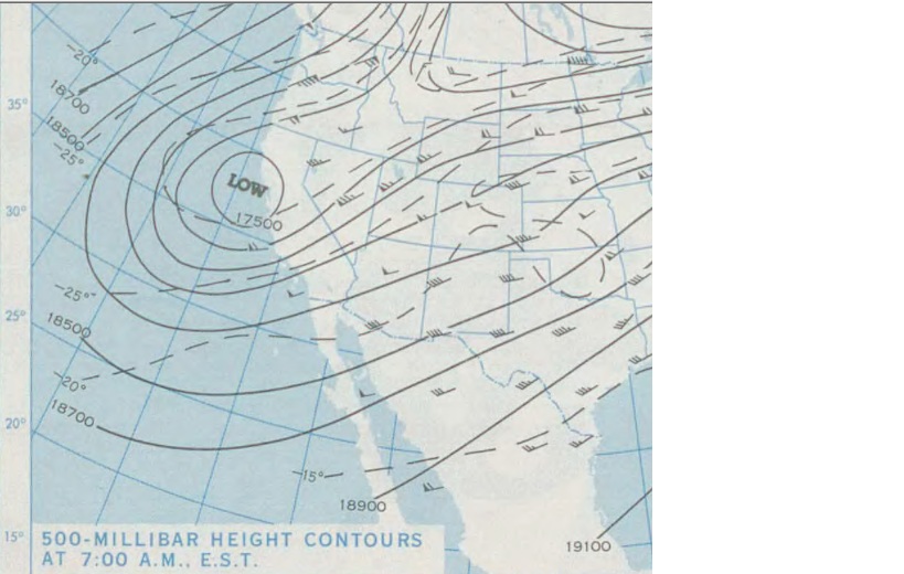
I have extracted the surface and 500 millibar maps from that date. See

http://ggweather.com/sf/Feb%205%201976%20500mb.jpg

http://ggweather.com/sf/Feb%205%201976%20sfc.jpg
The Oakland sounding from 12z on Feb. 5, 1976 had a 500mb height of 5280m and a 1000-500 thickness of 5220m.
The current (18Z) GFS has a 500mh height of 5320 m and a thickness of 5220 m. See http://wxweb.meteostar.com/sample/sample.shtml?text=KOAK and also
http://www.met.sjsu.edu/weather/models/gfs0.5deg-18/allsfc5.html and
http://www.met.sjsu.edu/weather/models/gfs0.5deg-18/all500relh.html .
The toughest part of the equation is whether the precipitation will phase with the coldest air during the coldest time of day. Any of a number of subtle changes to the airmass and its trajectory over the ocean could make dramatic differences to the eventual outcome. Stay tuned.
===========================================================
The NWS in SFO has issued this special weather statement:
WWUS86 KMTR 222338
SPSMTR
SPECIAL WEATHER STATEMENT
NATIONAL WEATHER SERVICE SAN FRANCISCO BAY AREA
338 PM PST TUE FEB 22 2011
CAZ006-505>513-516>518-528>530-231200-
SAN FRANCISCO-
338 PM PST TUE FEB 22 2011
…COLD STORM SYSTEM TO IMPACT OUR AREA STARTING ON THURSDAY…
…SNOW LEVELS EXPECTED TO DROP CLOSE TO SEA LEVEL BY FRIDAY NIGHT…
AFTER A QUIET WEATHER DAY TODAY AND WEDNESDAY…A RETURN TO COLD
WINTRY CONDITIONS ARE EXPECTED ACROSS THE SAN FRANCISCO AND
MONTEREY BAY REGION BY THURSDAY. A STRONG STORM SYSTEM CURRENTLY
IN CANADA WILL DIVE TO THE SOUTHEAST AND BE NEAR THE SAN FRANCISCO
BAY AREA FRIDAY NIGHT. AHEAD OF THE LOW…RAINFALL WILL SPREAD
ACROSS OUR AREA STARTING THURSDAY AND CONTINUING INTO FRIDAY.
RAINFALL AMOUNTS COULD EXCEED HALF AN INCH FOR CITIES WITH MORE
THAN AN INCH POSSIBLE FOR HIGHER ELEVATIONS. SNOW LEVELS WILL DROP
THROUGH THE DAY AND BE UNDER 1500 FEET FOR MOST OF SAN FRANCISCO
BAY AND BETWEEN 2000 AND 2500 FEET ON FRIDAY. SIGNIFICANT SNOW
ACCUMULATIONS WILL BE POSSIBLE FOR LOCAL MOUNTAIN RANGES. EVEN COLDER AIR WILL CONTINUE TO FILTER IN THROUGH FRIDAY NIGHT WITH SNOW LEVELS POTENTIALLY DROPPING DOWN TO SEA LEVEL.
ALTHOUGH THE STORM SYSTEM IS STILL A FEW DAYS AWAY…CONFIDENCE IS
FAIRLY HIGH THAT WE WILL SEE MUCH COLDER THAN NORMAL WEATHER AND
VERY LOW SNOW LEVELS. IT IS IMPORTANT TO NOTE THAT AT THIS TIME
THERE IS STILL SOME UNCERTAINTY WITH THE CHANCE FOR ACCUMULATING
SNOW AT VERY LOW ELEVATIONS. EVEN IF THE SNOW DOES NOT ACCUMULATE
AT SEA LEVEL…IT WILL LIKELY IMPACT LOCAL PASSES AND ANY ROADS
ABOVE THE 1000 FOOT LEVEL.
PERSONS WITH OUTDOOR ACTIVITIES AROUND SAN FRANCISCO AND MONTEREY BAY LATER THIS WEEK SHOULD PAY VERY CLOSE ATTENTION TO THE LATEST FORECASTS. REMEMBER TO ALWAYS CARRY AN EMERGENCY KIT IN YOUR CAR IN CASE YOU DO ENCOUNTER HAZARDOUS DRIVING CONDITIONS.
$$
BELL
Snow levels will be very low in LA County as well. I’ll stay indoors and watch the carnage on TV.
KyleK says:
February 23, 2011 at 7:45 am
Also, Mann’s, Trenberth’s, and Schmidt’s temperature “adjustments” will insure a higher temperature in SFran today compared with yesteryear, so the snow will surely melt before hitting the ground. We can thank the Team, and pal-reviewed publications like Science, Nature, and Climate Realist for this. If they manage somehow, thanks to us taxpayers, to hang on and stay in business, perhaps we can avoid the LIA coming the next 2 decades. If the “Team” can just adjust my temperature in New Hampshire, maybe I can avoid that next snowstorm!
I remember snow once in SF in the 10 yrs I lived there. The town goes insane. Well, more insane. It did not even stick. Wonder if the cold will cause a contraction quake… what interesting times we live in.
tty says:
February 23, 2011 at 3:22 am
“At Monterey, CA, on Christmas Day 1602 Father Ascension (Vizcaino Expedition) described the “mountains near this port were covered with snow” and their water bottles froze on the beach. ”
But that was in the LIA and during the “volcano winter” after the big Huaynaputina eruption. Not in our current unprecedentedly tipping-pointed era.
——-
True. But the Spanish did not return to colonize California for 150+ years after that visit. Although not mentioned anywhere in the history of that expedition, maybe they had Father El Hansenio along with them to explain that that snow and cold was a sign of climate disruption so severe and catastrophic that all life there was doomed, so why bother… [ do I need to add sarc?]
In any case, that photo of the SF area with snow reminded me of that event so I just noted it for a little context.
Driving over 17 on Sunday, I noticed quite a bit of snow on the higher peaks of the Santa Cruz Mountains, which is uncommon for these relatively short mountains only a few miles from the Pacific. I live in the foothills between Santa Cruz and Scotts Valley, about 2-300 ft elevation. I’m crossing my fingers that we’ll see snow on my lawn this Friday, such a novelty here in this mediterranean/maritime hybrid climate.
@Grant Hillemeyer Ha! Too right. I grew up in both Alameda and San Rafael, and remember several events like this. The ’76 event was my senior year in HS and we all piled into a Vista Cruiser and headed up into the Oakland hills. Not only canvas tennis shoes, but denim bell bottoms… Man, was that a fun time.
Is it just me, or have we seen a change in owl distribution? Barn owls (the ones with the dish-white face) don’t mind cold, but not real cold weather. Great Horned Owls are much more comfortable in cold, windy, snowy weather. There has been a distinct and sharp change from barn owls to horned owls in my barn over the past 6 years. Six years ago, all I had was barn owls. Then about 3-4 years ago, horned owls showed up. For a while they co-existed. This past year I have had nothing but horned owls. I wouldn’t be surprised if snowy owls started showing up. I’ll let you know. In the meantime, I wonder if the barn owls I used to have, that are now in San Fransisco, will be moving further South?
Btway, I used the above photo and story from SFO’s INSW here, http://funwithgovernment.blogspot.com/2011/02/san-francisco-snow-this-week.html
Pamela Gray says:
February 23, 2011 at 5:46 pm
Not sure where you live but that sounds more like an expanding Great Horned Owl population displacing the Barn Owls, mostly by preying on them. GHOs are a problem for the sacred Spotted Owl too. They are by far the top of the nocturnal food chain.
Because of almost total human tolerance to them now, GHOs are expanding into more open and agricultural habitats in many areas. Since they pick off chickens, once upon a time farmers used to kill them all the time while they loved having Barn Owls around because they were great mousers. Barn Owls have other problems – their low flight makes them prone to road kill – but what you describe sounds like the GHOs did it.
There are no end of unintended consequences of being nice to everything.
As for Snowy Owls, they show up in winters much further south than usual in synch with the boom-bust cycles of Arctic rodents, their primary food supply. In their ‘outbreak’ years they show up in some rather amazing places but those wandering birds do not represent any real range or range change. That said, I’m sure some AGW soothsayer could see one as a sure sign of the climate apocalypse.
I live in Los Gatos, which is in-between Santa Cruz and San Jose, right at the foot of the Santa Cruz Mtns. These people drive like crap in July, so if we get 1 inch, this place is gonna shut down.
The local paper in San Diego had a story today about this cold storm saying that Saturday could be the coldest day in San Diego since February 1975 and one of the top 10 coldest days on record.
Latest model run certainly looks cold! The powder in the mountains should be incredible, not the usual Sierra Cement!
“Pamela Gray says: In the meantime, I wonder if the barn owls I used to have, that are now in San Fransisco, will be moving further South?”
If they can’t get along with the loons any better than they did with the GHO’s then I’d suppose so.
As of Thursday night, both Weather Underground and weather.com are predicting snow for Santa Cruz on saturday. It’s raining right now but not too cold. Actually a bit refreshing for my preference.