UPDATE: Live The last radar image from Willis Island added below. The last radar image is truly striking.
Also, see below for the differences between the Australia hurricane scale and the familiar Saffir-Simpson scale used in the USA. They are not equal.
From Australia’s BoM, time to “get outta Dodge” as they say:

Simon at Australian Climate Madness notes this for rebuttal of the inevitable “Yasi caused by global warming” links that will be pushed on the blogs and by the press:
Tropical cyclone Mahina hit on 4 March 1899. It was a Category 5 cyclone, the most powerful of the tropical cyclone severity categories. In addition, Mahina was perhaps one of the most intense cyclones ever observed in the Southern Hemisphere and almost certainly the most intense cyclone ever observed off the East Coast of Australia in living memory. Mahina was named by Government Meteorologist for Queensland Clement Wragge, a pioneer of naming such storms.
Here’s what BoM has to say on their tracking page:
The forecast path shown above is the Bureau’s best estimate of the cyclone’s future movement and intensity. There is always some uncertainty associated with tropical cyclone forecasting and the grey zone indicates the range of likely tracks of the cyclone centre.
Due to the uncertainty in the future movement, the indicated winds will almost certainly extend to regions outside the rings on this map. The extent of the warning and watch zones reflects this.
This product is designed for land-based communities; mariners should read the coastal waters and high seas warnings.
Remarks:
SEVERE TC YASI IS A LARGE AND VERY POWERFUL TROPICAL CYCLONE AND POSES AN EXTREMELY SERIOUS THREAT TO LIFE AND PROPERTY WITHIN THE WARNING AREA, ESPECIALLY BETWEEN CAIRNS AND TOWNSVILLE.
THIS IMPACT IS LIKELY TO BE MORE LIFE THREATENING THAN ANY EXPERIENCED DURING RECENT GENERATIONS.
TC Yasi, CATEGORY 5, will continue to move in a west-southwesterly direction during the day. The cyclone is expected to cross the coast in the Innisfail area at about midnight.
Coastal residents within the warning area, and particularly between Cairns and Ayr are specifically warned of an EXTREMELY DANGEROUS SEA LEVEL RISE [i.e. storm tide] as the cyclone approaches, crosses the coast and moves inland. The sea is likely to steadily rise up to a level which will be VERY DANGEROUSLY above the normal tide, with EXTREMELY DAMAGING WAVES, STRONG CURRENTS and FLOODING of low-lying areas extending some way inland. People living in areas likely to be affected by this flooding should take measures to protect their property as much as possible, and be prepared to follow instructions regarding evacuation of the area if advised to do so by authorities.
DAMAGING WINDS with gusts to 90 km/hr that are currently developing on coastal islands, are forecast to develop about the coast by late morning and about the tropical interior overnight.
Between Cape Tribulation and Ingham these winds will become DESTRUCTIVE with gusts in excess of 125km/hr during the afternoon and early evening and VERY DESTRUCTIVE with gusts up to 300 km/hr between Cairns and Ingham during the evening as the cyclone approaches and crosses the coast. These VERY DESTRUCTIVE winds can also occur on the seaward side of hills to the north of the cyclone and are also forecast to reach the Atherton Tablelands.
Winds are forecast to ease about the east coast during Thursday morning as the cyclone moves inland.
FLOODING RAINS will develop from Cooktown to Sarina during the afternoon and then extend inland overnight.
People between Cape Melville and Sarina, extending inland to Croydon and Richmond should complete preparations quickly and be prepared to shelter in a safe place.
– Boats and outside property should be secured.
– For cyclone preparedness and safety advice, visit Queensland’s Disaster Management Services website (www.disaster.qld.gov.au)
– For emergency assistance call the Queensland State Emergency Service (SES) on 132 500 (for assistance with storm damage, rising flood water, fallen trees on buildings or roof damage).
People about the remaining tropical interior east of Camooweal and north of Winton should consider what action they will need to take if the cyclone threat increases.
– Information is available from your local government
– For cyclone preparedness and safety advice, visit Queensland’s Disaster Management Services website (www.disaster.qld.gov.au)
– For emergency assistance call the Queensland State Emergency Service (SES) on 132 500 (for assistance with storm damage, rising flood water, fallen trees on buildings or roof damage).
Name: Severe Tropical Cyclone Yasi
Details:
| Time (EST) | Intensity Category | Latitude
(decimal deg.) |
Longitude
(decimal deg.) |
Estimated Position
Accuracy (km) |
|
|---|---|---|---|---|---|
| 0hr | 7 am February 2 | 5 | 16.1S | 150.9E | 20 |
| +6hr | 1 pm February 2 | 5 | 16.7S | 149.1E | 45 |
| +12hr | 7 pm February 2 | 5 | 17.2S | 147.5E | 75 |
| +18hr | 1 am February 3 | 4 | 17.8S | 145.8E | 100 |
| +24hr | 7 am February 3 | 2 | 18.5S | 144.1E | 130 |
| +36hr | 7 pm February 3 | 1 | 19.8S | 141.1E | 190 |
| +48hr | 7 am February 4 | tropical low | 20.9S | 138.4E | 250 |
The next Forecast Track Map will be issued by 11:00 am EST Wednesday
===============================================================
UPDATE:
Commenter sHx writes:
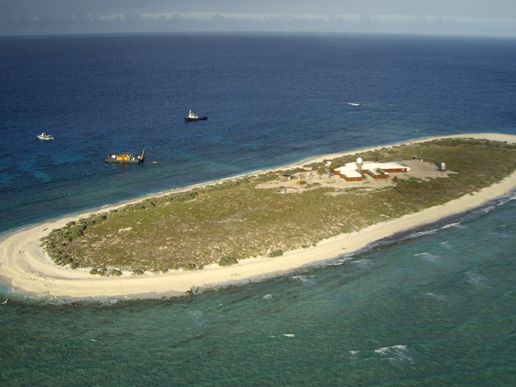
AS of this moment Yasi is right on top of Willis Island. http://en.wikipedia.org/wiki/Willis_Island
Apparently the island has a meteorological post. It even has radar! http://www.bom.gov.au/products/IDR412.loop.shtml

It must be frightening to be that radar operator looking at this, knowing when that eyewall hits you are going to be subject to Cat5 winds and you have a 30meter tall radar tower right next to you, and there’s really no shelter elsewhere on the island and no place to go. I wonder how long we’ll continue to get a signal from the Willis Island’s radar?
UPDATE2: Just about the time I pressed “update” the radar went out, the radar station is offline. The last image from the station is above. We hope for the best for the BoM employees there. The storm surge must be ferocious. Hopefully BoM evacuated them and they left the radar on “auto”. Given the size and composition of the island versus the size of the hurricane, Willis Island may very well be erased by this storm.
===============================================================
Good luck to our friends in Queensland, especially Dr. Bob Carter and Nigel, who helped during my tour in Townsville last year.
===============================================================
UPDATE 3: Hurricane expert Dr. Ryan Maue brings to our attention the differences in tropical cyclone scales. The Saffir-Simpson scale used maximum sustained one-minute winds while the Australian Region scale uses ten-minute averaged sustained winds. The convention to convert is (10-minute)*1.14 = 1-minute sustained (units are knots). This image combined from Wikipedia’s article.

The JTWC advisory intensity at 00Z Feb 2 of 125 knots is a strong Category 4 on the Saffir-Simpson scale. The Australian Bureau of Meteorology reports central pressure of 930 hPa, and backs out Category 5 winds from that. Also, feel free to call Yasi a “willy-willy“.
It was recommended for those who decided to stay for Katrina, they should use a permanent black marker to write on their torso their name and ID number so the cleanup crews can identify the body. Turned out to be good advice.
As I commented on Jo Nova’s site:
You have my prayers, for all they are worth. (hope much). Only God and good luck, can save us from natural variation. Well that and a little common sense. I’m in the middle of the Snowmageddon, here by Chicago, and the MSM may be worse than the storm. Why do they always seem to send idiots out to stand in the midst of the sort-of storm. Law of Averages would suggest a person, occasionally, would appear. Hope we all make it through.
Jim
Thanks Latitude 🙂 so water on land does have an effect – particularly warm water as it starts to mimic the same forces over the ocean.
Second question if cyclones/hurricanes take heat out of the ocean (with Yasi I would assume this would be a significant amount of heat) then how does that affect the current La Nina where the warm waters are pushed west to Australia – does the cyclone strengthen it or weaken La Nina and the flow of warm water?
In recent days SOI figures going up again.
Hey Phillip B yeah Lake Eyre already has a bit of water in it. Any more water in the Lake Eyre catchment will further fill it. As the land is already soggy then runoff we be increased. With Lake Eyre moving to being at least part full year after year then how does that affect our climate in the eastern states? Are we on a decadel (PDO) cycle of increasingly wet feedbacks (which would be further increased with Svensmarks theory) of increased cloudiness due to a quiet sun?
Lake Eyre satellite
http://www.lakeeyreyc.com/Status/latest.html
Lake Eyre basin is 1/6th the area of Australia – this rain band from the cyclone will need to get inland to affect it which is what the weather services are predicting.
http://www.lakeeyrebasin.org.au/
http://www.weatherzone.com.au/synoptic.jsp?d=3
Ross Brisbane,
The Queensland Climate Change report key findings,
increased flooding, erosion and damage in
coastal areas due to increased numbers of severe
tropical cyclones and sea level rise
cyclones occurring further south
reduced rainfall across most of Queensland
longer dryer period
difficulty in supplying water to meet urban and
agricultural demand due to decreasing rainfall
and runoff
As far as recent events are concerned, all of these predictions are wrong. Note, the first prediction is that due to increased numbers of severe cyclones. And this year has had a below average number of cyclones across Australia, severe and otherwise, and sea levels actually fell in 2010.
It’s interesting that a Global Warming believer can read this report and see its predictions coming true, when a neutral observer, such as myself, sees predictions that are hopelessly wrong based on recent events.
“… and there’s really no shelter elsewhere on the island and no place to go…”
Ryan, one must hope they designed a safe bunker for this kind of event.
+++
Ross from Brisbane: ” … it is not only factual, but gives EXTRAORDINARY insight into what climate and type of climate changes QLD will transition into within a global warming context over the next decade.”
Before buying into equaling climate change and global warming, you should first understand the mechanisms of atmospheric circulation. May I suggest you acquaint yourself with this paper first:
Leroux, Marcel (1993). The Mobile Polar High: a new concept explaining present mechanisms of meridional air-mass and energy exchanges and global propagation of palaeoclimatic changes. Global and Planetary Change 7, 69-93.
http://ddata.over-blog.com/xxxyyy/2/32/25/79/Leroux-Global-and-Planetary-Change-1993.pdf
Read and understand that the meteorological changes that we see since the 1970s are in fact debunking the global warming theory and indeed shows there is climate change but in a very different way. And please do not come back with HadCRUt or GISS stuff since we all know this is manipulated crap.
Fortunately, the four BOM staff were evacuated form Willis Island yesterday.
Fingers crossed for the best possible outcome.
Ross Brisbane says:
February 1, 2011 at 3:45 pm
Climate Change skeptical extinction may be expected by 2020.
Please don’t confuse ‘climate change skepticism’ with ‘anthropogenic climate change skepticism.
The climate has been changing, for better or worse for life on earth, for many thousands of years; the argument relates to the size and scale on Man’s effect on climate.
If you are going to post here, please be careful with the terms you use as generalisations add nothing to the discussion.
I am, thankfully, in Adelaide and trust that all in the path of this cyclone remain safe and well.
I’m in Brisbane, the recent floods got almost to our door eight hours before the flood max then mysteriously rose only another 200 mm or so, leaving us dry. My son left Cairns Base Hospital – on the bay, likely to be flooded, evacuated yesterday – to move to Royal Brisbane in the short space between our floods and their cyclone. Good timing.
The general drift of commentary I’ve seen here is (a) it’s impossible to say whether or not AGW/climate change is a factor in the current weather and (b) we’ve had regular cyclones throughout recorded history.
Some commenters/researchers are noting the effects of El Nino and La Nina climate cycles that affect weather in Eastern Australia, as well as the impact of the Pacific Decadal Oscillation, and defining 20-30 years cycles of high/lower cyclonic activity. It would appear that such patterns are not obviously related to any global warming. cf Mark Lawson, AFR, 21/1/11.
The current cyclone is expected to cause much greater damage than Cat 4 Larry five years ago, partly because of its greater intensity and spread and partly because it will hit towns with larger populations – 160,000 in Townsville – on flood plains which are already saturated and exposed to sea surges which might be up to 4 metres.
Aynsley Kellow says:
“Fortunately, the four BOM staff were evacuated form Willis Island yesterday.
Fingers crossed for the best possible outcome.”
LOL! You sly fellow.☺
I am seeing the absolute disgust at the global warming crowd with the current winter storm. I will not give you the link to the Huffington Post article on the storm, but the comment section, with comments like, “I have to shovel that damn global warming out of my driveway again, and the warmers hearing that comment from their neighbors again and again”, are getting a bit hostile. While we here at WUWT are expected to temper our rage, I fear the normal people will not temper their rage as much as we do. My radar is up for some major hostility on the issue.
Apparently the island has a meteorological post.
I think that should read “Apparently the island had a meteorological post.”
It was just reported in the Queensland premiers update that all the equipment has stopped sending data, it looks like it was wiped-out. Fortunately the 4 employees had already been evacuated.
That’s strange. Weather dot com doesn’t seem to have anything dire in the forecast for Townsville. http://www.weather.com/weather/tenday/ASXX0117
Sorry Smokey, but your humour escapes me.
To quote Manuel in Fawlty Towers, ‘Que?’
Hope all are settled in and properly prepared for this storm. At this point the die is cast for all those in the direct impact area.
I had the rather interesting experience of riding out a super typhoon in 1971 on board ship near Guam MI. It certainly got my attention. These storms occur naturally and do not need any “global warming” to form periodically.
Super Typhoon Amy (Etang) Duration April 29 – May 7 1971
Intensity 280 km/h (175 mph) (1-min), 895 hPa (mbar)
Larry
Now 295 kmph. Tracey 1974 Darwin blew the anemometer off at 280 kmph. My husband was in Darwin in Tracey – he cant watch what is happening. His helicopter was one of only two aircraft unscathed at Darwin Airport out of about 100. He says much of the damage in Darwin was the mini (as in small in size, not ferocity) cyclones within the system. A house gone, the one next to it unscathed.
In case you think that cyclones are predictable, here is a 2007 spaghetti map from the Australian Bureau of Meteorology showing the tracks of past cyclones:
http://i260.photobucket.com/albums/ii14/sherro_2008/CyclonesBOM.jpg
Next, here is a National Geographic Map reproduced with permission, for the more severe cyclones 1974-2006.
http://i260.photobucket.com/albums/ii14/sherro_2008/CYCLONESNATGEOG.jpg
The present concern, Yasi, is approximately on the same path as Larry (2006) on this second map.
The 3 features that engage me are –
(a) The cyclones often track well out to sea, then do a 90 degree left turn and head for the coast; and
(b) the systems often cross the coastline at right angles, on a large scale of resolution; and
(c) there are many cyclones whose paths are shown to continue over dry desert land for 2000 km or more, especially in West Australia. How?
BTW, Ross Brisbane who blogged above, the recent, severe Brisbane floods were not particularly related to the statement “Projections indicate an increase in two-hour, 24-hour and 72-hour extreme rainfall events for large areas of south-east Queensland, especially in the McPherson and Great Dividing ranges, west of Brisbane and the Gold Coast.” The Toowomba floods were possibly attributable to such a statement (only further time will validate or invalidate the forecasts); but there is a sharp mountainous divide between Toowoomba and Brisbane. The rainfall from the quote heads generally west. The flooding of Brisbane was largely flowing east from rain within the fairly small Brisbane basin, which is perhaps too small to model on a National basis. FWIW, the Toowoomba catchment is quie tiny as well. Maybe the problem in Toowoomba was enlarged by people building structures like the rail yards in old watercourses.
Back to Cyclone Yasi, the town of Innisfail in its path is usually wet. Average Dec-Feb (summer) rainfall is 450 mm or 17 inches, Mar-May (autumn) is 480 mm or 19 inches. It might help that the town is engineered to take high rainfall, to some extent.
Not as good as John Silver’s but here are a couple more.
MTSAT visible (stationary): http://www.goes.noaa.gov/FULLDISK/MTVS.JPG
MTSAT infrared (stationary): http://www.goes.noaa.gov/FULLDISK/MTIR.JPG
Since this thread brought it to my attention, I thought I’d look up the BOM data for the Willis Island station. It appears to have been there since the 1920s, though there have been some gaps. The picture Anthony found certainly implies that there should be minimal UHI impact on the data.
Looking at the maximum temperature figures, there doesn’t seem to be much of a trend:
http://www.bom.gov.au/jsp/ncc/cdio/weatherData/av?p_nccObsCode=36&p_display_type=dataFile&p_startYear=&p_c=&p_stn_num=200283
But the minimum temperature figures should a strong upward trend:
http://www.bom.gov.au/jsp/ncc/cdio/weatherData/av?p_nccObsCode=38&p_display_type=dataFile&p_startYear=&p_c=&p_stn_num=200283
I found that interesting, but I’m not sure what it means.
Yikes – I’ve got folks sitting right in its path. They’re off the coast of Townsville. Waiting for an email back as I write.
Hopefully, it’ll be just an interesting eyewitness account, rather than a tragedy.
Wind, pressure, temperature and humidity data from the Automatic Weather Station that BoM has in Willis Island can be seen at
http://www.bom.gov.au/jsp/watl/weather/obs.jsp?graph=all_obs&station=200283
It seems that wind anemometer and vane are now broken after reporting a maximum wind gust of 100 knots!!! The fall of the pressure is so dramatic, as well.
[youtube=http://www.youtube.com/watch?v=ML9h3I5Uktw&w=480&h=390]
This is Australia
Wow! The central pressure is an amazing 938!
http://www.bom.gov.au/products/IDQ60801/IDQ60801.94299.shtml
This is a deep, deep low. I can’t remember such a deep low in a TC.
Oh, and from the radar image that Anthony caught, you can see the eye of the storm is about 50km wide. That also is huge.
From a commenter at Jo Nova’s site, here’s a live webcam view of this storm approaching (now) which could be amazing to watch over the coming hours and days:
http://www.gorgecreekorchards.com.au/