UPDATE: Live The last radar image from Willis Island added below. The last radar image is truly striking.
Also, see below for the differences between the Australia hurricane scale and the familiar Saffir-Simpson scale used in the USA. They are not equal.
From Australia’s BoM, time to “get outta Dodge” as they say:

Simon at Australian Climate Madness notes this for rebuttal of the inevitable “Yasi caused by global warming” links that will be pushed on the blogs and by the press:
Tropical cyclone Mahina hit on 4 March 1899. It was a Category 5 cyclone, the most powerful of the tropical cyclone severity categories. In addition, Mahina was perhaps one of the most intense cyclones ever observed in the Southern Hemisphere and almost certainly the most intense cyclone ever observed off the East Coast of Australia in living memory. Mahina was named by Government Meteorologist for Queensland Clement Wragge, a pioneer of naming such storms.
Here’s what BoM has to say on their tracking page:
The forecast path shown above is the Bureau’s best estimate of the cyclone’s future movement and intensity. There is always some uncertainty associated with tropical cyclone forecasting and the grey zone indicates the range of likely tracks of the cyclone centre.
Due to the uncertainty in the future movement, the indicated winds will almost certainly extend to regions outside the rings on this map. The extent of the warning and watch zones reflects this.
This product is designed for land-based communities; mariners should read the coastal waters and high seas warnings.
Remarks:
SEVERE TC YASI IS A LARGE AND VERY POWERFUL TROPICAL CYCLONE AND POSES AN EXTREMELY SERIOUS THREAT TO LIFE AND PROPERTY WITHIN THE WARNING AREA, ESPECIALLY BETWEEN CAIRNS AND TOWNSVILLE.
THIS IMPACT IS LIKELY TO BE MORE LIFE THREATENING THAN ANY EXPERIENCED DURING RECENT GENERATIONS.
TC Yasi, CATEGORY 5, will continue to move in a west-southwesterly direction during the day. The cyclone is expected to cross the coast in the Innisfail area at about midnight.
Coastal residents within the warning area, and particularly between Cairns and Ayr are specifically warned of an EXTREMELY DANGEROUS SEA LEVEL RISE [i.e. storm tide] as the cyclone approaches, crosses the coast and moves inland. The sea is likely to steadily rise up to a level which will be VERY DANGEROUSLY above the normal tide, with EXTREMELY DAMAGING WAVES, STRONG CURRENTS and FLOODING of low-lying areas extending some way inland. People living in areas likely to be affected by this flooding should take measures to protect their property as much as possible, and be prepared to follow instructions regarding evacuation of the area if advised to do so by authorities.
DAMAGING WINDS with gusts to 90 km/hr that are currently developing on coastal islands, are forecast to develop about the coast by late morning and about the tropical interior overnight.
Between Cape Tribulation and Ingham these winds will become DESTRUCTIVE with gusts in excess of 125km/hr during the afternoon and early evening and VERY DESTRUCTIVE with gusts up to 300 km/hr between Cairns and Ingham during the evening as the cyclone approaches and crosses the coast. These VERY DESTRUCTIVE winds can also occur on the seaward side of hills to the north of the cyclone and are also forecast to reach the Atherton Tablelands.
Winds are forecast to ease about the east coast during Thursday morning as the cyclone moves inland.
FLOODING RAINS will develop from Cooktown to Sarina during the afternoon and then extend inland overnight.
People between Cape Melville and Sarina, extending inland to Croydon and Richmond should complete preparations quickly and be prepared to shelter in a safe place.
– Boats and outside property should be secured.
– For cyclone preparedness and safety advice, visit Queensland’s Disaster Management Services website (www.disaster.qld.gov.au)
– For emergency assistance call the Queensland State Emergency Service (SES) on 132 500 (for assistance with storm damage, rising flood water, fallen trees on buildings or roof damage).
People about the remaining tropical interior east of Camooweal and north of Winton should consider what action they will need to take if the cyclone threat increases.
– Information is available from your local government
– For cyclone preparedness and safety advice, visit Queensland’s Disaster Management Services website (www.disaster.qld.gov.au)
– For emergency assistance call the Queensland State Emergency Service (SES) on 132 500 (for assistance with storm damage, rising flood water, fallen trees on buildings or roof damage).
Name: Severe Tropical Cyclone Yasi
Details:
| Time (EST) | Intensity Category | Latitude
(decimal deg.) |
Longitude
(decimal deg.) |
Estimated Position
Accuracy (km) |
|
|---|---|---|---|---|---|
| 0hr | 7 am February 2 | 5 | 16.1S | 150.9E | 20 |
| +6hr | 1 pm February 2 | 5 | 16.7S | 149.1E | 45 |
| +12hr | 7 pm February 2 | 5 | 17.2S | 147.5E | 75 |
| +18hr | 1 am February 3 | 4 | 17.8S | 145.8E | 100 |
| +24hr | 7 am February 3 | 2 | 18.5S | 144.1E | 130 |
| +36hr | 7 pm February 3 | 1 | 19.8S | 141.1E | 190 |
| +48hr | 7 am February 4 | tropical low | 20.9S | 138.4E | 250 |
The next Forecast Track Map will be issued by 11:00 am EST Wednesday
===============================================================
UPDATE:
Commenter sHx writes:
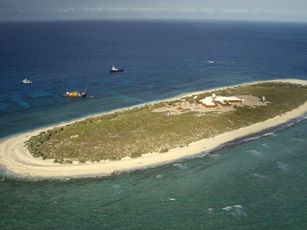
AS of this moment Yasi is right on top of Willis Island. http://en.wikipedia.org/wiki/Willis_Island
Apparently the island has a meteorological post. It even has radar! http://www.bom.gov.au/products/IDR412.loop.shtml

It must be frightening to be that radar operator looking at this, knowing when that eyewall hits you are going to be subject to Cat5 winds and you have a 30meter tall radar tower right next to you, and there’s really no shelter elsewhere on the island and no place to go. I wonder how long we’ll continue to get a signal from the Willis Island’s radar?
UPDATE2: Just about the time I pressed “update” the radar went out, the radar station is offline. The last image from the station is above. We hope for the best for the BoM employees there. The storm surge must be ferocious. Hopefully BoM evacuated them and they left the radar on “auto”. Given the size and composition of the island versus the size of the hurricane, Willis Island may very well be erased by this storm.
===============================================================
Good luck to our friends in Queensland, especially Dr. Bob Carter and Nigel, who helped during my tour in Townsville last year.
===============================================================
UPDATE 3: Hurricane expert Dr. Ryan Maue brings to our attention the differences in tropical cyclone scales. The Saffir-Simpson scale used maximum sustained one-minute winds while the Australian Region scale uses ten-minute averaged sustained winds. The convention to convert is (10-minute)*1.14 = 1-minute sustained (units are knots). This image combined from Wikipedia’s article.

The JTWC advisory intensity at 00Z Feb 2 of 125 knots is a strong Category 4 on the Saffir-Simpson scale. The Australian Bureau of Meteorology reports central pressure of 930 hPa, and backs out Category 5 winds from that. Also, feel free to call Yasi a “willy-willy“.
Ross Brisbane says:
February 1, 2011 at 3:45 pm
Climate Change skeptical extinction may be expected by 2020.
========
So I took a look at the linked artile and it presents a document that’s little more than IPCC and UNFCC meme.
The BOM isn’t the best at forecasting seasonal patterns let alone patterns that are decades away.
See:
Could the Australian BOM get it more wrong?
http://joannenova.com.au/2010/12/could-the-australian-bom-get-it-more-wrong/
“On August 24 the Australian BOM had pretty much no idea that any unusual wetness was headed their way. Toss a coin, 50:50, yes or no. Spring 2010 was going to be “average”, except in SW Western Australia where they claimed “a wetter than normal spring is favoured.”
What follows were 100 year floods, or at least above average rain to nearly every part of the nation bar the part that was supposed to be getting more rainfall. In the chart below, all shades of “blue” got above average rainfall. The dark blue? That’s the highest rainfall on record.”
BOM Forecasting Skill
from the same article:
Warwick Hughes linked to this unusually candid report of BOM seasonal rain forecasts (Vizard 2005).
“The results indicate that the forecasting system had low skill.”
They go on to explain just how low:
“Brier Skill Score and the receiver operating characteristic values were uniformly close to the no skill value.”
I don’t think I’ll be tendering my Skeptics badge, any time soon, based on Australia Climate Predictions.
Ross Brisbane:
“Further noting about Mahina it was nearly two months later”
Since when is March 4th (when Mahina hit), two months later than Feb 2nd?
The latitude shift is bunk, since cyclones have hit lower latitudes many times before, eg Wanda and Zoe.
Having said that, I sincerely hope you’re safe up there (I’m in Adelaide).
Ross Brisbane says:
February 1, 2011 at 3:45 pm
It is of course fine to be a climate skeptic – but if may I am in QLD right now. It’s enough to knock the skeptic out of anyone.
Climate Change skeptical extinction may be expected by 2020.
================================================
Ross, serious question
If no one had ever invented global warming/climate change….
….what would you call this?
At 1000 hrs Australian Eastern Daylight Saving Time on 2 Feb the Premier of Queensland and the 2 IC Police gave a press conference that essentially much that has been said above. The intensity is now 5 on the Australian scale. The eye is 35 km in diameter and the system is tracking slightly south of west at 35 km per hour. It was predicted to be the most severe storm to make landfall in Australia in living memory. Landfall is expected 2200 hrs AEST.
Storm surge depend on local geography and time of tides; high figues of 4 m are quoted, with 2 m expected generally. Some estimates are as high as 6 m.
The entire Cairns Hospital was evacuated to Brisbane last night, over 100 patients who were too ill for discharge.
There must be a high probability of multiple deaths. There will also be a wringing of hands over climate change. As a preamble, see
http://blogs.news.com.au/heraldsun/andrewbolt/index.php/heraldsun/comments/who_will_be_the_first_to_blame_global_warming/
Not a happy situation.
This may seem like a dumb question but as Queensland is already flooded/moisture laden is the crossing of the cyclone from ocean to land likely to be less of an impact because of the buildup of moisture on the land. In other words how does the effect of a flooded landscape affect the cyclone degenerating as opposed to a parch/dry/drought landscape?
http://www.bom.gov.au/products/national_radar_sat.loop.shtml
Willis Island is at
S 16 17 13. E 149 57 50
on Google Earth. There are a few photos.
The reef is to the northeast, but I think the winds will be coming in from the west, so they won’t help soften the impact.
I moved to SW Florida July 4th 2004. Six weeks later we had Charley, made landfall near the island of Cayo Costa, Florida as a 150 mph (240 km/h) Category 4 hurricane with a pressure of 941 mbar (hPa; 27.49 inHg) at approximately 3:45 p.m. EDT on the 13th of August. An hour later, the hurricane struck Punta Gorda as a 145 mph (230 km/h) storm. However, the eye had shrunk before landfall, limiting the most powerful winds to an area within 6 nautical miles (11 km) of the center.3:45 p.m. EDT , 15 miles north of Cape Coral where I live.
I took my mother and I to my brothers house in Fort Lauderdale across Alligator Ally the day before it was scheduled to make landfall. I went back the day after to begin repairs but my mother could not return for a week due to power outages. You do not want to mess with anything greater then a cat3, just get out. I was glad to see the sun going into a sustained solar minimum. I’ve bee going naked on my hurricane insurance the past 2 years.
Ross Brisbane, if there are enough predictions you can always find some that turn out to be true. Although I’ll note you are just assuming these forecasts are correct without checking.
FYI, I checked the BoM’s cyclone forecast for the current season
http://www.bom.gov.au/climate/ahead/tc.shtml
And see their forecast was for,
The largest increase in tropical cyclone numbers is expected to occur in the Western region, where 11-12 tropical cyclones are forecast (4-5 more than the average value of 7 tropical cyclones).
Then checked cyclone activity to date this season and found there have been just 3 Western Region cyclones.
http://www.bom.gov.au/cyclone/history/index.shtml
So while the cyclone season has still got a few weeks to go, clearly the BoM’s forecast was far off the mark and we (I live in WA) will have a below average cyclone season. As we have had for the last 7 or 8 years (from memory).
Run from the water, hide from the wind. If some authority figure tells you to evacuate, do it. If you won’t, he’ll ask for names of your next of kin. He won’t be joking.
Australian Greens Senator Christine Milne already jumped on the Yasi-caused-by-climate-change bandwagon:
http://www.abc.net.au/news/stories/2011/02/01/3127184.htm?section=justin
Some people are simply an embarrassment to the species.
Re Willis Island: I was under the impression there were 5 people on the island, and 3 have been evacuated, with 2 remaining. Could be wrong.
All safe and prepared here (near Sarina- on southern edge of gale force winds, so not in any danger), but ready to clear out if it heads south. Best wishes everybody.
“Monster cyclone knocks out weather radar
By Kim Lyell
Category five Cyclone Yasi has knocked out the weather bureau’s radar system on Willis Island, about 450 kilometres east of Cairns in far north Queensland.
The weather bureau’s radar and wind speed measurements on the island failed just before 9am (AEST).
The bureau says the maximum wind speed recorded before the equipment went down was 185 kilometres an hour.
Three weather observers and a technician left the island yesterday.”
http://www.abc.net.au/news/stories/2011/02/02/3127757.htm?section=justin
Poor old Innisfail — it copped a shellacking off Cyclone Larry in 2006, and has slowly been rebuilding over the past 5 years, and it looks as if it’s going to get flattened again.
I was in Cairns when Larry hit, i.e. about 100kms away, and that’s as close I ever want to come to one of these frightening weather events.
Praying that everyone stays safe.
If I’m not mistaken, there aren’t many roads in that part of Australia. Good luck getting out.
John Silver says:
February 1, 2011 at 4:41 pm
http://www.bom.gov.au/products/national_radar_sat.loop.shtml
======
Rain bands hitting Townsville and just off shore in Cairns:
http://www.bom.gov.au/products/IDR213.loop.shtml
http://www.bom.gov.au/products/IDR193.loop.shtml
Rain bands in Bowen and Mackay:
128 km Bowen Radar Loop
http://www.bom.gov.au/products/IDR243.loop.shtml
128 km Mackay Radar Loop
http://www.bom.gov.au/products/IDR223.loop.shtml
It looks like Yasi will dump a lot of rain in the Lake Eyre catchment and we may see the highest recorded level in Eyre (1974) exceeded.
Although to give you an idea of how much water that will require.
The highest recorded level in Lake Eyre was in 1974 but it would take the average flow of Australia’s largest river, the Murray to maintain that level. The Danube River would fill Lake Eyre to the 1974 level in forty-five days; the Mississippi in twenty-two days, and the Amazon in three days.
Hi Ross from Brisbane this is Carrie from Qld. You are new here. Good on ya mate. If you keep coming back and reading the many scientific articles here, plus visit all the blogs linked and listed, you might change your mind. That is of course, if you have a true scientific curiosity and if you are not a person who is benefitting financially via your job or business from the global warming agenda, and/or are not a member of the church of green.
twawki says:
February 1, 2011 at 4:40 pm
This may seem like a dumb question but as Queensland is already flooded/moisture laden is the crossing of the cyclone from ocean to land likely to be less of an impact because of the buildup of moisture on the land. In other words how does the effect of a flooded landscape affect the cyclone degenerating as opposed to a parch/dry/drought landscape?
=========================================
I’ve forgotten the name, but one recent hurricane in Florida strengthened in the middle of the state.
It crossed south Florida from west to north east, and strengthened when it got over the water in the Everglades, in the middle of the state.
Brisbane Times
Too late to leave: drivers told to stay put
Tony Moore
February 2, 2011 – 11:32AM
http://www.brisbanetimes.com.au/environment/weather/too-late-to-leave-drivers-told-to-stay-put-20110202-1ad2f.html
“Police have urged “frantic” motorists trying to escape Cairns that it is too late to try and outrun Cyclone Yasi.
“Heading south on the highway to outrun the cyclone, it is probably too late for that now,” Regional Traffic Co-ordinator Inspector Robert Waters said.
“Basically if you haven’t already left Cairns, if you haven’t worked out a specific destination within a reasonable driving distance, you have probably left it too late and we suggest you go to the shelters that are advertised by the councils.”
By good fortune I took a copy of the Willis island data to PDF just before is went down.
This appears to show the eye of the cyclone, amazing. If it is valid.
Quickly thrown up this page with a link to the PDF.
http://daedalearth.wordpress.com/
Philip Bradley
I am not a BOM “basher” by this cherry picking. Neither am I a CSIRO basher. Where’s that leave you? I do not expect you to think as I do. I do you expect you to be a true sceptic of climate change, keep an open mind to all flows of information and not shut out what you find maybe an unacceptable reach of your understanding.
I do not like cherry picking – read the ENTIRETY of QLD Climate Change Report – it is not only factual, but gives EXTRAORDINARY insight into what climate and type of climate changes QLD will transition into within a global warming context over the next decade.
It also clearly instructs one to better plan their housing location, be selective about the type of house, (an insurance evaluative position, policy and protection) and other named events that QLD will absolutely transition into over the next coming decade.
The key to all this all is not government and political issue but you and me – the daily citizen being able plan with known parameters of foresight rather then hindsight.
The State Government gave an excellent report – it is worthy of anyone reading it for their own well being, to protect their families and plan a better lifestyle with harmful catastrophic event minimisation.
Stay safe in Australia … but other places too.
Apparently the US is in for a blast from the weather. It was 30 below in Alberta yesterday. There is a huge jet stream mvoing south to Texas right now and affected flights in Texas today. Tonight and tomorrow it will be worse. On the west side of the jet stream it is warm – it was plus 4 C at my farm and 100 km east in Red Deer it was 21 below C today.
The jet stream goes straight south to Texas and then turns north picking up moisture from the Gulf to mix with cold air. Our local weather forecast said there could be 30 cm of snow from a bit east of the Rocky Mountains all the way to Chicago, from Texas to the Canadian border, with 15 to 20 cm on the east coast and tornadoes in the south east. A nasty big weather system covering most of the eastern US and Canada.
The northern jet stream has really been doing its meandering thing this year.
Good luck to all of you in unsettled weather. Stay off the roads.
A ham operator friend in the south pacific helping with civil defense said one cyclone he helped out had greater than 230 km/hr winds (142 mph) – because that was when the anemometer blew away!
His rule of thumb to keep metal sheeting on was to use 7 bolts per square meter!