
Guest post by Dr. Walt Meier
Steve Goddard has written several contributions on sea ice lately, particularly on the PIPS model, and as expected there has been much discussion about sea ice as we’ve entered another summer melt season. I can’t possibly comment on everything, but I will provide some information on a few points. In this post, I’ll tackle the PIPS and PIOMAS model issues.
In a following post, I’ll address the other three issues. I include several peer-reviewed journal references for completeness and to give a sample of the amount of research that has gone into investigating these issues. Note that as usual, I’m speaking only for myself and not as a representative of the National Snow and Ice Data Center or the University of Colorado at Boulder.
PIPS 2.0 and PIOMAS
When I saw PIPS being mentioned, it brought back fond memories for me. I haven’t worked with PIPS recently, but several years ago, I was a visiting scientist at the U.S. National Ice Center (NIC). NIC is a joint Navy, NOAA, and Coast Guard center whose primary duty is to provide operational support for military and civilian ships in and near ice-covered waters.
NIC is the primary customer of the PIPS model outputs, which they’ve used the operational forecasts to help produce their operational ice analyses. As a researcher at NIC, one of the projects I was involved with a project to evaluate the operational forecasts. I was a co-author on a couple peer-reviewed journal articles (Van Woert et al., 2003; Van Woert et al., 2001), where we found that the operational forecasts showed some skill at predicting ice edge conditions over the following 1-5 days, but the forecasts had difficulty during times of rapid ice growth or melt. (Steve referenced one of the papers – thanks Steve!). So I can perhaps clarify and explain some issues about PIPS and its applicability for studying climate and its appropriateness for studying climate compared to PIOMAS. Here are some relevant points:
1. As mentioned above, PIPS is an operational model. It is run to forecast ice conditions over 1-5 day intervals. The basic model physics is the same for any sea ice model – ice grows when it is cold, melts when temperatures are above freezing, and moves around due to winds and other factors. However, model details and how each type of model is implemented and run differ depending on the application. Similarly, climate and weather models include the same basic underlying physics, but you wouldn’t run a climate model to forecast weather or vice versa.
2. Validation of PIPS (see references above) has been done for sea ice extent, concentration, and motion near the ice edge (an important factor in the day-to-day changes in the ice edge). This is because the ice edge is the area of operational interest – i.e., the focus is on providing guidance for ships to avoid getting trapped in the ice. Very little validation was done for ice thickness estimates, particularly in the middle of the ice pack.
PIOMAS has been specifically validated for ice thickness using submarine and satellite data (http://psc.apl.washington.edu/zhang/IDAO/retro.html). Of course, the PIOMAS model estimates are not perfect, but they appear to capture the main features of the ice cover in response to forcings over seasonal and interannual scales.
3. PIPS 2.0 was first implemented in 1996 using model components developed in the 1970s and 1980s. These components capture the general physics of the ice and ocean well, but are basic by today’s standards. This provides suitable simulations of the ice cover, especially for short-term forecasts (which are most sensitive to the quality of the atmospheric forecast that drives the model). There has been a lot of sea ice model development since the 1980s, which according to a recent abstract for a conference presentation at the Joint Canadian Geophysical Union and Canadian Meteorological and Oceanographic Society 2010 Meeting, will be implemented in the next generation PIPS model, PIPS 3.0. However that is not yet being run operationally and thickness fields on the website are from PIPS 2.0. The primary references for PIPS 2.0 are Hibler (1979), Hibler (1980), Thorndike et al. (1980), and Cox (1984).
PIOMAS includes much more up-to-date model components (developed during the late 1990s early 2000s) with significant improvements in how well the model is able to simulate the growth, melt, and motion of the ice cover. In particular, the model do a much better job at realistically moving the ice around the basin and redistributing the thickness (i.e., rafting, ridging) in response to wind forcing. Thus, the thickness fields are likely to be more realistic than PIPS. The primary references for PIOMAS are: Zhang and Rothrock (2003), Zhang and Rothrock (2001), Winton (2000), Zhang and Hibler (1997), Dukowicz and Smith (1994).
4. The PIPS website has very limited information about the model or the model output products; it contains only image files; there are no raw data files, no documentation, no source code, no citation of peer-reviewed journal articles. A few articles can be found online elsewhere, and there are a few journal articles, but overall the information is quite sparse. This isn’t a big issue for PIPS, and I don’t fault those who run the PIPS model, because it has a small, focused user community who are familiar with the model, its characteristics, and its limitations.
The PIOMAS website contains detailed documentation including several peer-reviewed journal articles describing the model; it also contains model outputs, images, animations, and source code. Of course, the amount of documentation doesn’t say anything about the quality of the model outputs. But I think most people today agree that for climate data being widely-distributed and which is being used to make conclusions about climate change, it is a good idea to have data and code freely available.
So, which model results do I trust more? For operational forecasts, I might use PIPS. And PIPS probably does capture some aspects of the longer-term changes. But for the reasons stated above, I would trust the PIOMAS model results more for seasonal and interannual changes in the ice cover. I very much doubt that anyone familiar with the model details would unequivocally trust PIPS over PIOMAS.
But what about the PIOMAS volume anomaly estimates? How can they be showing a record low volume anomaly when there is less of the thinner first-year ice than in previous years as seen in ice age data? Doesn’t this mean that PIOMAS results are way off? Well, first, it is quite possible that the model may currently be underestimating ice thickness. No model is perfect. However, there is a possible explanation for the low volume and the PIOMAS model may largely be correct.
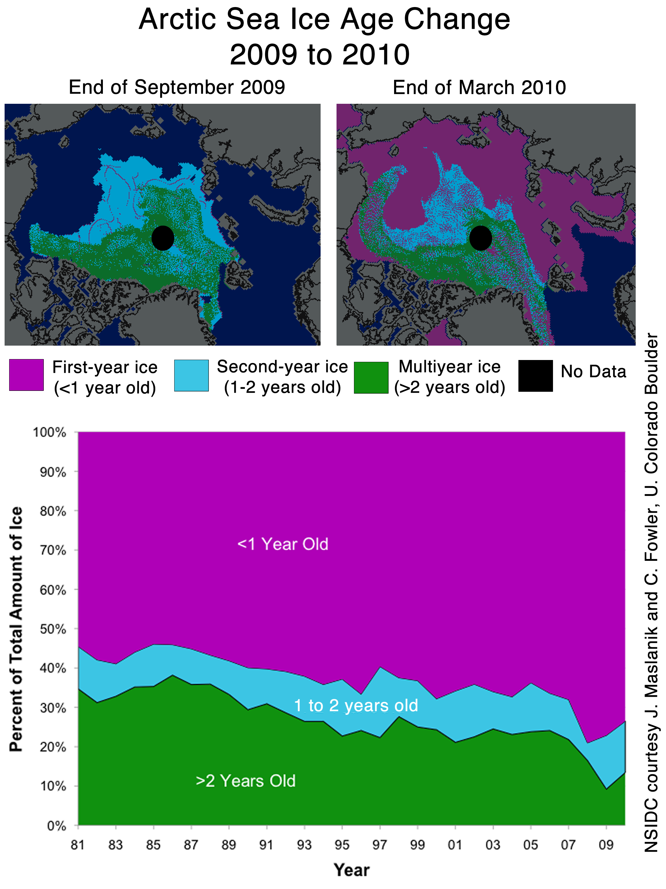
The areas that in recent years have been first-year ice that are now covered by 2nd and 3rd year ice will increase the volume – in those regions. However, compared to the last two years, there is even less of the oldest ice (see images below – I also included 1985 as an example of 1980s ice conditions for comparison). The loss of the oldest, thickest ice may more than offset the gain in volume from the 2nd and 3rd year ice. Also, it’s been a relatively warm winter in the Arctic, so first-year ice is likely a bit thinner than in recent years. Finally, the extent has been less than the last two years for the past couple of months. So the PIOMAS estimate that we are at record low volume anomaly is not implausible.

Early May ice age for: 1985 (top-left), 2008 (top-right), 2009 (bottom-left), and 2010 (bottom-right). OW = open water (no ice); 1 = ice that is 0-1 year old (first-year ice), 2 = ice that is 1-2 years old (2nd year ice), etc. Images courtesy of C. Fowler and J. Maslanik, University of Colorado, Boulder. Updated from Maslanik et al., 2007.
What does this all mean for this year’s minimum? Well, much will depend on the weather for the rest of the summer. As NSIDC states in its most recent post, we’ve expected we may see the rapid decline begin to slow because the melt will soon run into older, thicker ice, which will slow the loss of ice. Steve has said essentially the same thing and indeed we’ve the rate of loss slow over the past few days. Of course, there still a lot of time left in the melt season, and pace of melt continue to be relatively slow or it may speed up again, so we’ll see what happens. Regardless of what happens this summer though, the most important fact is that, despite some areas of the Arctic being a bit thicker this year, the long-term thinning and declining summer ice extent trend continues.
One final note about both PIPS and PIOMAS: Steve has claimed that “everyone agrees that PIPS 2.0 is the best data source of historical ice thickness”. Well, no scientist would even agree that what PIPS 2.0 produces are data! Being a data person myself, this is a bit of a pet peeve, but it’s important to make the distinction that model outputs are not data. Models are tremendously useful for obtaining information where data doesn’t exist (i.e., data sparse regions, historical periods without data), for projecting future changes, and for understanding how physical processes interact with each other (e.g., changes in climate due to changes in forcings).
However, model results are simulations, not observed data. And if there is good data available, I trust data over model estimates. And there is good historical data on ice thickness from submarine and satellite records (Kwok and Rothrock, 2009) and from proxy thickness estimates from ice age data (e.g., Maslanik et al., 2007). These data clearly show a long-term thinning trend. And while 2010 has relatively less of the thinner, first-year ice than the last couple of years, the ice cover is still much thinner than it was in earlier years. And it is clear that the models don’t entirely capture the spatial distribution of thickness correctly. As an example, compare the first-year ice in the ice age figure above with the PIPS 2.0 estimate from the same time period (below). In May, PIPS showed most of the central Arctic covered by ~3+ m ice, all the way to the Siberian coast. This is simply not realistic because the ice age data indicate first-year ice on much of the Siberian side of the Arctic (see images above), which would average at most 2 m. Thus Steve’s comparison of May 2010 and May 2008 with PIPS data is not valid because the model results are capturing observed spatial patterns of thickness.

References
Kwok , R. and D.A. Rothrock, 2009. Decline in Arctic sea ice thickness from submarine and ICESat records: 1958–2008, Geophys. Res. Lett., 36, L15501, doi:10.1029/2009GL039035.
Maslanik, J.A., C. Fowler, J. Stroeve, S. Drobot, J. Zwally, D. Yi, and W. Emery, 2007. A younger, thinner Arctic ice cover: Increased potential for extensive sea-ice loss, Geophys. Res. Lett., 34, L24501, doi:10.1029/2007GL032043.
Key PIPS 2.0 Model references:
Cox, M., 1984. A primitive equation, 3-dimensional model of the ocean, Geophysical Fluid Dynamics Laboratory Ocean Group Technical Report, Princeton, NJ, 1141 pp.
Hibler, W.D. III, 1979. A dynamic thermodynamic sea ice model, J. Phys. Oceanogr., 9(4), 815-846.
Hibler, W.D. III, 1980. Modeling a variable thickness sea ice cover, Mon. Weather Rev., 108(12), 1943-1973.
Thorndike, A.S., D.A. Rothrock, G.A. Maykut, and R. Colony, 1975. The thickness distribution of sea ice, J. Geophys. Res., 80(33), 4501-4513.
Key PIOMAS Model references:
Dukowicz, J.K., and R.D. Smith, 1994. Implicit free-surface method for the Bryan-Cox-Semtner ocean model, J. Geophys. Res., 99, 7791-8014.
Winton, M., 2000. A reformulated three-layer sea ice model, J. Atmos. Oceanic Technol., 17, 525-531.
Zhang J., and W.D. Hibler III, 1997. On an efficient numerical method for modeling sea ice dynamics, J. Geophys. Res., 102, 8691-8702.
Zhang, J., and D.A. Rothrock, 2001. A thickness and enthalpy distribution sea-ice model, J. Phys. Oceanogr., 31, 2986-3001.
Zhang, J., and D.A. Rothrock, 2003. Modeling global sea ice with a thickness and enthalpy distribution model in generalized curvilinear coordinates, Mon. Weather Rev., 131, 845-861.
“So the PIOMAS estimate that we are at record low volume anomaly is not implausible.”
Mystery solved: Trenberth’s ‘haunting’ missing heat.
http://www2.ucar.edu/news/missing-heat-may-affect-future-climate-change
Could you expand on the idea that old ice can be thinner than 1st year ice under certain conditions related to location of compaction and ridging? First year ice subjected to compaction and pressure can be quite thick compared to multi-year ice that has migrated to an area conducive to thinning.
Wow! Thanks for taking the time for such an excellent explanation. More than anything, I think we all can look forward to the time that we start getting the real data from CryoSat 2.
However, model results are simulations, not observed data. And if there is good data available, I trust data over model estimates. And there is good historical data on ice thickness from submarine and satellite records (Kwok and Rothrock, 2009) and from proxy thickness estimates from ice age data (e.g., Maslanik et al., 2007). These data clearly show a long-term thinning trend.
================================
“Long term” on what scale?
Dr. Meier, You are a damn good scientist and that is why we listen to you here.
But what do you mean by “long term”…and are these “long terms” explainable at least in part by idioms such as the AMO, PDO and maybe other yet unnamed “long-term” cycles?
Chris
Norfolk, VA, USA
“the long-term thinning and declining summer ice extent trend continues.”
Well, I suppose that depends on what one means by “long term trend”. I mean, if you make a trend line that starts, say, 1990 to today, sure, the trend line still trends downward. But the trend line in minimum since 2007 trends upward. So it is valid to say the downward trend continues but it is also valid to say that the trend shows signs of reversing.
What I found most valuable in the article was this reminder:
“The areas that in recent years have been first-year ice that are now covered by 2nd and 3rd year ice will increase the volume – in those regions. However, compared to the last two years, there is even less of the oldest ice”
So in 2007 while we lost a lot of ice >5 yo, we also lost ice of ALL ages. So going into 2008, we would have seen less 2yo, 3yo, and 4yo ice than we saw in previous years. So in 2008 the remaining 4yo ice minus any losses becomes 5yo. Then in 2009, any remaining 5yo ice minus losses becomes 6yo, etc.
So that is why it will take at least until 2020 or so to completely recover from the 2007 anomaly. Ice inventory must be rebuilt and the inventories of ice that is 7yo is lower than it was before 2007. The amount of 5yo ice won’t return to “normal” (normal meaning in this case levels that reflect what would be considered normal conditions and not excessively depleted due to anomalous wind or other events) until 2011, 5 years after 2007. Then take 5 more years for the inventory better 5yo and 10yo (I would guess there isn’t a lot of ice over 10 years old) so now we are in to 2016.
So basically, the amount of ice >5yo will probably continue to decline until the first 2008 ice reaches 5 years old. When 2008, 2009, and 2010 ice “matures” that number is only then going to begin to climb so even if things have turned the corner, we aren’t really going to see much improvement until 2012 or so. There is an indication that things MIGHT be turning the corner, but it is premature to say they HAVE turned the corner and another wind event between now and 2016 could set the whole thing back to even worse than 2007.
Thank you Anthony for also letting the ‘other side’ speak up their arguments here. Doesn’t happen in RealClimate.
By August 3, the PIOMASS ice extent forecast will be far off the mark.
Mark it on your calendar.
We won’t have an El Nino to kick around in the Arctic this year.
So while there may be less multi-year ice now than 4 years ago, we’ll have to do the same thing we did for SC24:
Watch and wait.
Meanwhile, the 30 yr global sea ice sits at zero anomaly.
So, if the ultimate scenario plays out, the Arctic will turn into an open sea, and the Antarctic will cut the Atlantic off from the Pacific at the kneecaps with permanent ice. And the global sea ice will still be sitting at zero anomaly.
thank you Walt for finally setting the record straight about PIPS2.0, R. Gates tried hard to, but perhaps now that it’s come from a scientist who has worked with the model, others will finally understand what R. Gates was saying all along.
Good job!
Personally I’m happy to wait a few days to see a graph of actual data only. I don’t need a model that predicts the next few days but that needs to be altered when the model gets it wrong.
Thanx again Anthony, and you too Dr. Walt.
Sea Ice extents and areal trends are just as susceptible to the Black Swan outlier as anything else in the climate or the stock market. You may think that everything point to higher & higher, or lower & lower, but watch out. One big swing the other way and you’re looking like a re-run of “The Coming Ice Age”.
Specifically, what do we know of the AO/PDO and Nino SST’s that tells us what comes next?
I second the request to see a definition of “long term.” Given that the planet has warmed since the end of the LIA, it seems likely that there should have been a trend toward lower ice volumes as well. So is a century “long term,” or is 10 years “lomg term?”
http://www.ipsnews.net/news.asp?idnews=51826
Dr. Walt Meier,
Just moved you to the ‘actual scientist’ side with some of the impressive thoughts you portrayed within:
– Models are simulations and never create data. Data is from observations. Agree.
– Observed data always takes precedence over any model estimates. Agree.
– PIOMAS is likely to be more realistic than PIPS. Likely is a key word for scientists when still in question. Thanks for refraining with “is” when that matter is still questioned.
One thing I wish you would have placed in the “always” category. New does not immediately mean better. More complex does not immediately mean better. That can only be determined through time with proven better results which is never guaranteed in complex models.
Noticed you carefully isolate the ice age data input to PIPS from the other observations. Could you give us a bit more on the places this data is compiled and stored and which is currently being used?
You also mentioned satellite measurements of ice thickness, how is that currently measured and by which instrument (or is it an inferred parameter from other measurements such as the various sounders)?
Thank you for taking the time to add some clarity I this matter.
Dr Meier, as one familiar with PIPS2, can you clarify how volume should be estimated?
The model provides average thickness and concentration fields. Is the concentration already taken into account when generating the thickness field?
That is: should total volume be calculated as (area x average thickness) or as (area x average thickness x concentration)?
Thanks, Dr. Meier, for a great post and for taking time to share some of your experience and expertise. Also very much appreciate the even-tempered tone of the post in outlining the areas of agreement and disagreement with Steve.
“there is good historical data on ice thickness from submarine and satellite records (Kwok and Rothrock, 2009) and from proxy thickness estimates from ice age data (e.g., Maslanik et al., 2007). These data clearly show a long-term thinning trend.”
Chris (savethe sharks) beat me to it, but I’d like to second his call for a definition. “long term thinning trend” sounds worrying, but without a start date it is UTTERLY MEANINGLESS.
I suspect that neither of the models used by PIOMAS and PIPS 2.0 give a good estimate of ice volume and we will have to wait for Cryosat 2 data before we start having good estimates.
In the mean-time we to have the Cryosphere satellite maps for sea ice concentration, and this shows that Arctic ice 13 July 2010 is in much better condition than it was on the same date in 2008 (2009 missing for this date). Have a look and see what you think.
http://a.imageshack.us/img24/8725/deetmp4704.png
“long term”?
Climate is 30 years of weather. The ice satellite have been recording data since 1979.
That is 1 (one) climate data point.
One lousy, stinking data point can not be made into a curve that can be extrapolated.
One data point is the shortest term possible.
There are no data to make any predictions on at all, sorry.
John Silver:
Very good point. It is very difficult to argue a trend on such a small amount of data.
However…
As Steven Goddard is very fond of telling everybody, ice melts when it gets warmer and freezes when it gets colder.
Sea ice conditions in the Arctic are a symptom of changes in temperature so we can use
trends in temperature data as a proxy for the prospects for Arctic sea ice. We can therefore make a pretty good guess that if global average temperatures continue on a rising trend then the chances are that the amount of Arctic sea ice will continue on a falling trend.
Now, we may have only one 30-year climate data point for sea ice, but the HadCrut3 temperature series goes back to 1850, which is 5 full data points if you end with the
most recent full year (2009) and start in 1860. Not much to go on, but the best we
have.
Do you think that 5 lousy, stinking data points are enough to extrapolate a trend?
Most climate scientists say “yes” but a few say “maybe” but I no of none that say “no”,
not even Lindzen and Spencer go that far.
Right… so what do those 5 lousy stinking data points tell us?
Below are the five full 30-year average data points in the HadCRUT3 record ending with the most recent full year:
1860-1889 -0.31
1890-1919 -0.42
1920-1949 -0.16
1950-1979 -0.12
1980-2009 0.25
These can be plotted on this chart:
http://a.imageshack.us/img37/4525/tempsx.png
Overall the trend is 0.56c during that period. However I think you would agree that the slope for the 90 years 1950-2009 is rather steeper than the slope 1860-1949.
Now I am no climate scientist, but the most recent data suggest that, despite a “pause”
in the rate of growth over the last 10 years, the last 30 year trend (from -0.12 to 0.25) is still inexorably up.
Based on this data, what are the chances that the next 30 years will be warmer than the last 30 years?
Regardless of whether you think that the warming seen so far is man made or natural, the outlook for the Arctic sea ice over the next 30 years is not good. No amount of cherry picking data and literature by the severely Confirmation Bias afflicted Steven Goddard is going to change that.
Correction to my comment on the slope of the graph, that should of course have been
“However I think you would agree that the slope for the 90 years 1920-2009 is rather steeper than the slope 1860-1949.”
You want to know what is “long term?” About half an average human life-span. You can’t “save the planet” if you’re dead. : )
Matthew L says:
July 14, 2010 at 3:12 am
The latest ‘data point’ shows the Arctic warming and the Antarctic cooling.
That data point is neutral to the global temperature.
Could it be that the hockey stick missed the puck?
Can somebody take a minute to remind me why I should care about how much ice there is in the Arctic? Sometimes getting too close to the trees misses the wood entirely.
Apart from the poor cuddly-wuddly polar bears (who seem to have miraculously discovered how to swim), little else lives there. And the ice is floating so whether its there or not makes no difference to sealevels.
Is it all not just a biiiig yawn?