Updated 8AM PST Thursday 8/27
Danny continues. It now has 60 mph sustained winds.
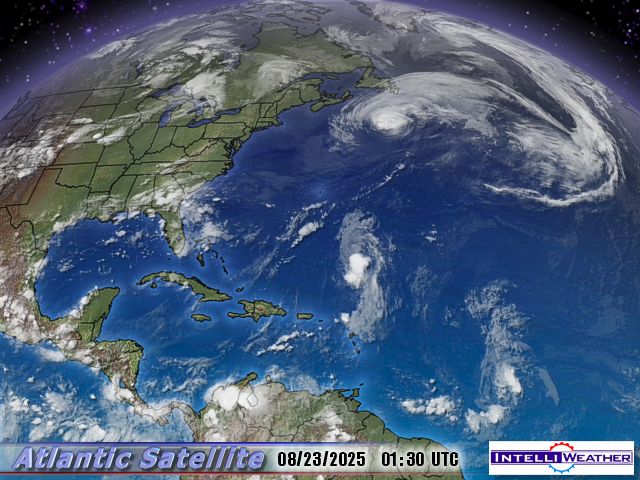
TS Danny is visible in the center of the image below. This satellite image will update every 30 minutes.
Animate this image: >>> ![]() OR Switch to Hurricane Sector View
OR Switch to Hurricane Sector View
- Click for larger image
NOTE: Commenter “nogw” tips us to this unique sea surface temperature image that appears to show the “cold track” left by hurricane Bill (last week off the east coast turning toward Nova Scotia) as it transported energy from the ocean to the atmosphere.

The probability plot for 120 hours out shows Danny following a similar track and likely to make a sharp turn to the northeast, affecting NY, MA, ME and Nova Scotia, but with no landfall. With SST’s lower in that area, it may not strengthen much.
![[Image of probabilities of tropical storm force winds]](http://www.nhc.noaa.gov/storm_graphics/AT05/refresh/AL0509_PROB34_F120_sm2+gif/083948.gif)
BULLETIN

TROPICAL STORM DANNY ADVISORY NUMBER   5

NWS TPC/NATIONAL  HURRICANE CENTER MIAMI FL   AL052009

1100 AM EDT THU AUG 27  2009

...CENTER OF DANNY WOBBLES WESTWARD...

INTERESTS FROM THE  CAROLINAS NORTHWARD TO NEW ENGLAND SHOULD MONITOR

THE PROGRESS OF DANNY.  A  TROPICAL STORM WATCH MAY BE REQUIRED FOR

PORTIONS OF THIS AREA LATER  TODAY.

FOR STORM INFORMATION SPECIFIC TO YOUR AREA IN THE  UNITED

STATES...INCLUDING POSSIBLE INLAND WATCHES AND  WARNINGS...PLEASE

MONITOR PRODUCTS ISSUED BY YOUR LOCAL NATIONAL WEATHER  SERVICE

FORECAST OFFICE.  FOR STORM INFORMATION SPECIFIC TO YOUR  AREA

OUTSIDE OF THE UNITED STATES...PLEASE MONITOR PRODUCTS ISSUED

BY YOUR  NATIONAL METEOROLOGICAL SERVICE.

AT 1100 AM EDT...1500 UTC...THE CENTER  OF TROPICAL STORM DANNY WAS

LOCATED NEAR LATITUDE 27.5 NORTH...LONGITUDE 73.1  WEST OR ABOUT

320 MILES...510 KM...NORTHEAST OF NASSAU AND ABOUT 550  MILES...

885 KM...SOUTH-SOUTHEAST OF CAPE HATTERAS NORTH  CAROLINA.

DANNY IS MOVING SOMEWHAT ERRATICALLY TOWARD THE NORTHWEST  NEAR

13 MPH...20 KM/HR.  THIS GENERAL MOTION IS EXPECTED TO  CONTINUE

TODAY...WITH A TURN TOWARD THE NORTH AND AN INCREASE IN  FORWARD

SPEED FORECAST ON FRIDAY.

MAXIMUM SUSTAINED WINDS ARE NEAR 60  MPH...95 KM/HR...WITH HIGHER

GUSTS.  SLOW STRENGTHENING IS POSSIBLE DURING  THE NEXT COUPLE OF

DAYS.

TROPICAL STORM FORCE WINDS EXTEND OUTWARD UP  TO 205 MILES...335 KM

FROM THE CENTER.

ESTIMATED MINIMUM CENTRAL  PRESSURE IS 1006 MB...29.71 INCHES.

...SUMMARY OF 1100 AM EDT  INFORMATION...

LOCATION...27.5N 73.1W

MAXIMUM SUSTAINED WINDS...60  MPH

PRESENT MOVEMENT...NORTHWEST OR 310 DEGREES AT 13 MPH

MINIMUM CENTRAL  PRESSURE...1006 MB

THE NEXT ADVISORY WILL BE ISSUED BY THE NATIONAL  HURRICANE CENTER AT

500 PM EDT.
The discussion I read yesterday said Danny’s circulation was only “slightly” more tropical than extratropical. It was apparently a tough call in calling it a “tropical” storm.
Danny is another hoax
crosspatch (9:45:06) …You mean “Danny (Boy)” aka “Londonderry Air” aka…[HWGA…]
Ric Werme (10:43:55)…But as you may know the “Hurricanes of the Arctic(and
Antarctic)”
the polar lows, may have warm cores….
I agree this is a rather peculiar Nino. Just back from a visit to the heart of Ninoland (Galapagos) where it is supposed to be hot, wet and green during a Nino. It was cool, dry and brown.
The locals said it was rather cloudier than usual for the time of year, otherwise nothing special.
Intersting ‘cold track’, which I would think is due more to cold water uplifting, than atmospheric energy transport.
Were the High July SST’s significantly impacted by the unusually low level of tropical atlantic storm activity?
Thanks Ric Werme (10:43:55)
I’m guessing there’s an occluded front of sorts to the east of the core. On the discussion they call the core a low level circulation, but it looks more like a mid level low to me. That could push midlevel air into the front from the west. On visible satellite it’s more of a mess than a tropical storm.
“He’s a scientist you know!””
Yup. But he isn’t a climatologist. He’s an astrophysicist.
STAFFAN LINDSTROEM (12:15:07) :
No, I don’t, however several nor’easters that “bomb out” (the scientific term is bombogenesis!) off the new England coast develop something that looks like an eye. The suspicion is that while the water is way too cold to support a true tropical storm, the even colder air aloft combined with the baroclinic energy of the nor’easter limits how far the inrushing air can come and an eyewall of sorts develops. Or something like that. Unfortunately, no one has ever been ready with a hurricane hunter plane and daring enough to fly into such an icy storm.
http://www.theweatherprediction.com/habyhints/188/
http://www.toddgross.com/todd_gross_new_england_we/2007/02/bombogenesis_an.html
The NHC is not longer expecting Danny to become a hurricane, though they note some models still do. From http://www.nhc.noaa.gov/text/refresh/MIATCDAT5+shtml/DDHHMM.shtml
The happiest tropical storms have an anti-cyclonic region above them to help blow out all the air that the storm convects upward. The notes about dry air can really clobber a big storm. While shear blows off the tops of the convection, entraing dry air cuts off convection at its knees and can amazingly quickly knock a cat 5 storm down to cat 3 or 2.
For something as messed up as Danny, dry air just seems to be another factor against development. I think the relatively light wind means that it doesn’t suck a huge volume of dry air so it takes more time for the impact to be realized.
I just looked at the most recent “live” radar/satellite images in animation, and it appears Danny is already turning to the east. Actual path seems to be NNE, with a movement of about thirty minutes of longitude. It’s hard to tell, because the storm center is too disorganized to see an “eye”, or an actual center.
I have dove the Gulf of Mexico for 32 years, sometimes after these storms have passed through. The normal surface temperature in the Gulf for summer can exceed 88F, and in the wake of these storms, the water is indeed colder to a depth of (as much as) 20 feet. Generally, the temperature difference is physically as striking as this satellite photo suggests. “Experts” have written that heat is only removed from the top 4 feet or so, but that is grossly in error in my experience. Indeed, these things are heat engines, and remove large quantites of heat from the surface of the ocean. For those of us who experience them regularly, it is striking how hot it is inside the hurricane itself, unlike inside a thunderstorm.
Gerry Parker
Admittedly much of the discussion here is over my head, but appreciate reading the threads.
I have learned a ton since stumbling on to the site.
I have a question, maybe something for Bill Gates and Co to consider.
Are hurricanes and typhoons possibly Mother Nature’s way of releasing some excess heat from the oceans?
And do the last 2 tracks, Bill and Danny, suggest now the water is not warm enough to feed from?
Thanks everyone.
The shortwave loop
http://www.ssd.noaa.gov/goes/flt/t1/loop-ir2.html
seems to show Danny’s circulation best. I’m more convinced this morning that it is tropical, just with lots of WSW shear. The circulation center seemed to be moving west but then became more stationary (from 7:45 to 10:15 UTC)
Waddya mean “no landfall?” What do you think Nova Scotia’s made of? Scotch mist? Remember who kept you lot in whisky during prohibition, eh?
Gerry Parker (18:26:30) :
I have had the same experience (diving)- and agree with everything you just said.
Well Danny’s a big flop too; keep the kiddies away from the coast, in case there’s a wave out there; alternatively, if you had taught them to swim, when they were young; you wouldn’t have to worry about waves out there.
But hey; the weather channel has to have something to talk about besides the weather !
This is August 31st, 4 days after this topic and the cool ocean path still persists. I note the waters off W. Africa where these things are born is also a lot cooler.
Well here we are into September and there doesn’t seem to be an active hurricane thread here at the moment.
So where is all the West African weather going? Have a look at this evenings EUMETSAT image of West Africa. That’s a lot of convection for Southern Algeria and the Atlas Mountains.
From Algerie Meteo