 This post on sea level reality came up in comments, posted by the author of the Climate Sanity website, Tom Moriarty.
Tom did an excellent job of visually illustrating the history of Boston Harbor and man’s plight in dealing with it, so I thought it would be worth sharing here for WUWT readers. In fact I’m so impressed, I’ve added Tom to the WUWT blogroll.
Of all the talk about sea level rise, it is interesting to point out that at least in Boston, man has easily outraced the sea. The worry about sea level is real, but the ability of man to adapt is clearly illustrated in the comparative maps. Just a note, I’ve modified the original blink comparator animation to make it a bit easier to watch. – Anthony
From Climate Sanity:
Boston, you have been warned. Sea levels are rising , and if one of the IPCC’s five scenarios is correct, the world’s oceans will rise somewhere between 18 and 59 cm (7 to 23 inches) by 2100. If that isn’t terrifying enough for the people living on the New England coast, the Boston Globe now tells us that the ocean near Boston will rise 8 inches more than the world average. How will the hapless rubes of Boston cope with this onslaught of Atlantic water?
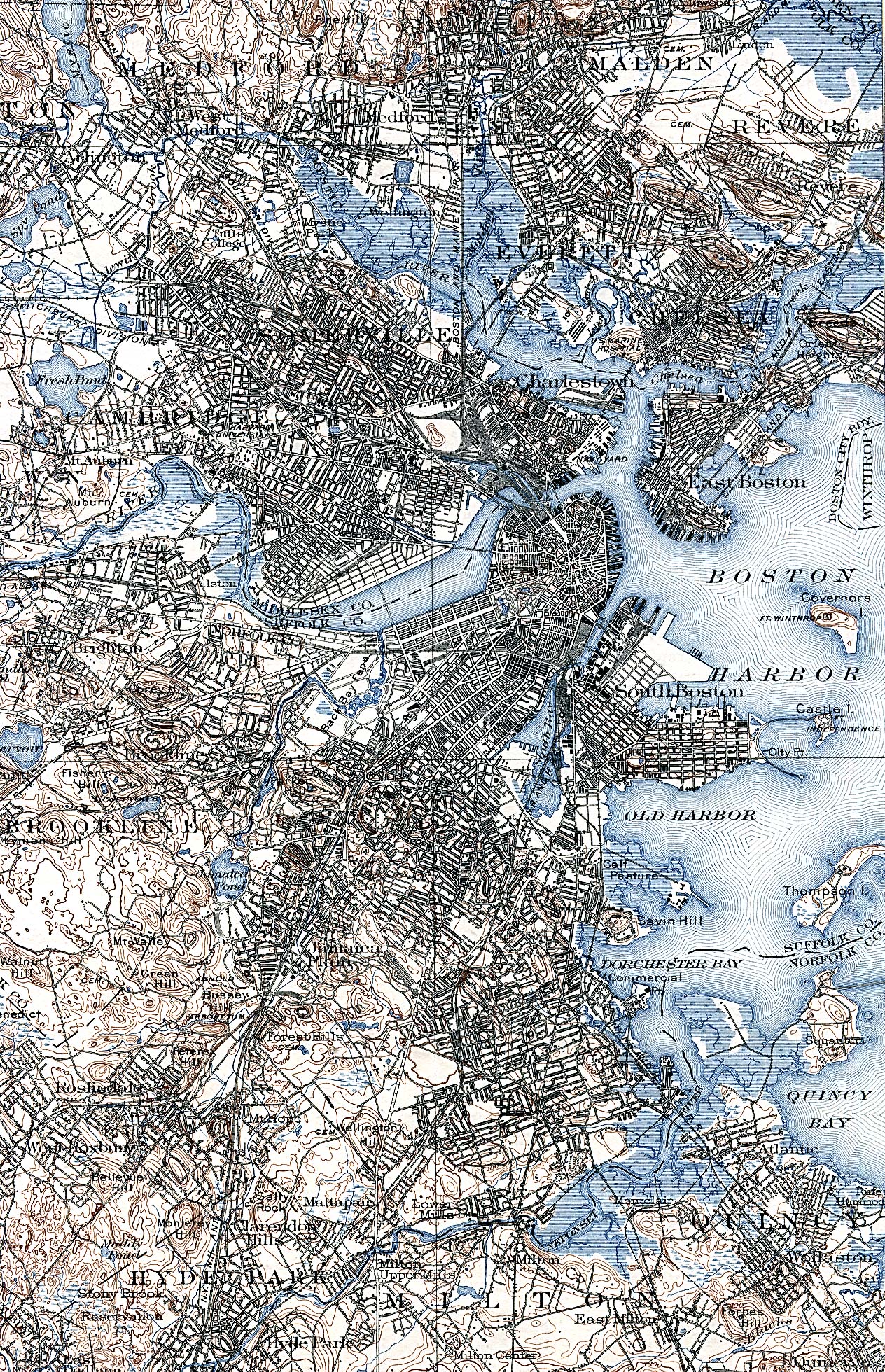
I wouldn’t lose to much sleep worrying about the folks in Boston when it comes to pushing back against the ocean. Excerpts from the following maps were used to make an animation of the changing coastline in Boston:
- A 1775 map showing the Boston area with the rebel military works. Note especially the isthmus, known as Boston Neck< that connects the town of Boston to the mainland.
- An 1838 George W. Boynton engraving of Boston area from a Thomas G. Bradford atlas.
- USGS map of Boston area.
- A 2009 satellite image from Google Earth
The top of the animation shows the maps after photoshopping to make the land and water more obvious. The bottom of the animation shows the unaltered excerpts of the maps or images.

The panic prone will argue that our Bostonian ancestors dealt with a static ocean, not a rising ocean. Not so fast. Check out the NOAA graph below (click inside graph to see it in context at NOAA site). It shows a sea level rise rate of 2.63 mm/yr for the last 100 years in Boston. At that rate it will rise 23.9 cm (9.4 inches) by 2100.

Boston sea level rise data from NOAA. Click in image for view in context.
Anyone who panics over the IPCCs 100 year projections of rising sea levels does not understand the perseverance and ingenuity of free people. Then there are others, like James Hansen, who enjoy the feeling of panic so much that that they exagerate the probable sea level rise for this century to get their thrills. But that is a story for another day…
Oddly enough older cities tend to retain their street layouts.
The basic street plan of the Roman City of London, c. 100 AD, remains to this day even though the City was largely razed by the Great Fire of 1666. There were grand ideas about how to rebuild, Wren and all that, but the need for speed, the land ownership and land rights, and perhaps an innate conservatism defeated them. So when you scurry along some alley or another such as Birchin lane your feet are following the same path as those of a thousand or even two thousand years ago.
And the ultimate in one upmanship, the Olde Cheshire Cheese, a pub or inn which has been there for over six hundred years and was burned down in the Great Fire. It proudly displays a plaque saying ‘Rebuilt 1667’. It used to be my local thirty years ago and very good too: Marston’s pedigree and a splendid steak and kidney pudding in the upstairs dining room. I don’t know what it is like today, probably ruined by some Pubco.
Kindest Regards
sukiho (04:56:03) : so the millions of people in third world countries that produce a lot of the worlds food by farming flood plains should commute 100s of miles each day in their non existent cars?
No, I would expect them to live in floating homes (i.e. live aboard boats) or in light hand built homes on raised platforms over the flood area (as they often do). The problem isn’t 3rd worlders living traditionally, the “problem” is modern western capital intensive urban metroplexes like New Orleans built in such a place. That’s the “just dumb” part. A thatch and pole hut is easy to move or rebuild as needed and putting one of them near / over the rice paddy makes excellent sense. (Though I’d personally choose a live aboard catamaran … but they may not be near enough to navigable water.)
Frankly, even a modern urban metroplex, if done in the Dutch style, makes sense. Those folks have brains and are willing to use them!
Saw a wonderful home design from Holland. The “basement” is a sealed hull. In a dyke failure, the whole home floats up (retained in place via a couple of big poles that it has big rings around). All the utilities connect with flex connectors. Very well thought out. Easily done in New Orleans… so of course we are not doing it.
It’s not so much about the “where” you build that makes it “dumb”, it’s the “how” you build that makes it “dumb”. Build a traditional U.S. suburban tract home or a traditional US urban high rise at or below sea level with poor dikes that are known to be less capable than the expected storms will deliver (Cat 3 in a Cat 5 zone) – Now that’s what I call dumb. Rebuilding the same way after a Cat almost 3 causes flooding?… Priceless.
Hey Holland! Why don’t you buy New Orleans (real estate prices are low right now) and turn it into a New Little Holland … at least then it would be done right and bright.
Francis (09:13:01) :
“Here’s the rub. Do you build the sea walls around the harbor and up the rivers for the 2100 sea level rise?”
Which sea level rise is that Francis? If it tracks along with AGW predictions of temp rise, drought, hurricane increase, polar ice melt, tropical disease vectors, polar bear extinctions, food riots, refugee migration, and market collapse – we can retire the defcon 4 alerts. What the Hansen and Gore exercise in hysteria has nicely demonstrated is how natural variability rules the roost. See E.M. Smith’s comment about SF Bay retreat for example.
If however the need to build sea walls arises, why would such infrastructure not fall under the Obama Administration’s New-WPA funding Program?
“Apart from the concrete, how do you protect the system from terrorists?”
1.8 million civilian Federal employees, and 1.4 million active military men and women – to start with.
You didn’t miss anything in your history books except, perhaps, that we have so few cities 4,000 years old because we managed to mismanage the land well enough to make the cities unlivable. Babylon has gone back to desert. The cedars of Lebanon are long gone, leaving rapidly eroding, relatively unproductive desert mountains in their place. Jericho is still occupied, but that’s largely because it was in a quite inhospitable desert to begin with, and the ocean needs to rise over the mountains before Jericho gets hurt from sea damage. Come to think of it, maybe we should study Jericho more closely. A 2,000 foot high levee (I’m guessing at the height) might be of use to some modern cities.
Ed Darrell (19:22:32) :
“So the only problem I see is that we need to manage the sediments a bit better…”
Fantastic advice! You’re only about 4,000 years late.
Oh, BTW, the Bangladesh link:
http://www.nytimes.com/2009/03/20/world/asia/20bangla.html?_r=1
has such evidence that “manaaging the silt a bit better” works as:
Instead of allowing the silt to settle where it wants, Bangladesh has begun to channel it to where it is needed — to fill in shallow soup bowls of land prone to flooding, or to create new land off its long, exposed coast.
The efforts have been limited to small experimental patches, not uniformly promising, and there is still ample concern that a swelling sea could one day soon swallow parts of Bangladesh. But the emerging evidence suggests that a nation that many see as indefensible to the ravages of human-induced climate change could literally raise itself up and save its people — and do so cheaply and simply, using what the mountains and tides bring.
and
When the chief engineer of the local water board, Sheikh Nurul Ala, came to measure it, he saw that in four years, Beel Bhaina had risen by as much as three feet or more near the river bank, and almost as much farther inland. Today, it is a quilt of green and gray square patches of paddy, cut by square ponds to cultivate fish and shrimp.
Ed Darrell,
Give it up. E. M. Smith pwned you. You are only making it last longer. Why not raise the white flag and wait for the next battle?
Mike
Ed Darrell,
are you jumping the shark??
a 2000 ft levee?? You are trouncing Hansen and Gore with that one!!
By the way, none of the areas you mention were in existence 4000 years ago.
Of course, the Great Pyramid COULD have been!!! Why not talk about it?? PLANNED so that it is on some of the most tectonically stable land in the world and just a wee bit above sea level!!
The surrounding structures are being excavated from the sand. Please tell us your catastrophic story of how mankind CAUSED this desertification that has buried so much of ancient Egypt!!
HAHAHAHAHAHAHAHAHAHAHA
I guess the Anasazi, Mayans, Aztecs, and other unnamed natives of the Americas CAUSED the climate change that wiped them out also??
HAHAHAHAHAHAHAHAHAHAHA
You warmers are such a HOOT!!! The more you talk the more we realise how ~snip you are!!!
Ed Darrell posts on his own blog:
“Of course, that sort of hardening of sites is exactly what the wetlands protection under Section 404 of the Clean Water Act aimed to slow or stop, and it is part of the cause of trouble in the Mississippi Delta and other places unhardened, where the effects of hardening ports are pushed.”
I can just imagine the headlines:
Obama, along with the UN urges the Netherlands and Bangladesh to let “Nature Run Her Course”
The Netherlands along with Bangladesh have been taking extreme measures to prevent sea level rise. Not only is this contrary to Section 404 of the Clean Water Act, but it is also contrary to the letter AND the spirit of the IPCC’s efforts to mitigate Global Warming through carbon investments. Rajendra Pachauri said, “These monies that are being thrown away by the Netherlands, Bangladesh and any other country that tries to adapt to rather than mitigate sea level rise, would be more properly be spent by the UN to curtail the use of carbon and related GHG pollutants. How many brackish water and sea water species must be lost because of the selfish actions of a few maverick countries that believe their rights supersede the rights of the global community? These very very bad countries demonstrate the failings of localism and are reason enough for the UN to take drastic measures against them and any others who would destroy our beloved Earth.
The president said, “Don’t they realize that they are adversely impacting wetlands?” He also announced that all monies set aside for the hardening of the levies in and around New Orleans will be forwarded to the UN and that the United States of America is now firmly on the side of any species that may be inconvenienced by humans. “Why put a bandage on the problem when we can eliminate it completely by getting rid of CO2?”, he asked.
E.M.Smith (15:59:32) :
Neven (13:21:02) : After how many inches of rise does it become too costly to defend the entire coastline?
According to my wife, 6 inches …
Bad man!
Ed Darrell sounds like the U.S. version of George Monbiot. At his site he’d be at a loss for words if he couldn’t use “denialist.”
From Ed’s [rarely visited] blog header: “Striving for accuracy in history, economics, geography, education, and a little science.” [Emphasis on “little” science. Very little.]
Ed refers to another site as “sleepy.” That’s a hoot, since Ed’s site has all of seven (7) comments — and five of those are a conversation between Anthony and Ed. Now that’s a sleepy site!
And Ed isn’t afraid to post his conclusions, right or wrong: “Climate warming is real. The effects of warming are real and quite problematic already.” [Ed’s emphasis]
So, Ed, got a question for you: What color is the sky on your planet? Because here on planet Earth, the climate is cooling.
E.M.Smith (15:14:27)
This is another memory, from a ’60’s drive from SF to Sacramento. Of looking over the Sacramento River levee, and seeing a (seagoing?) freighter…that was above me. This levee was mentioned in Katrina’s aftermath as the probable next to go. And the conclusion was that the resulting lake would become permanent. It wouldn’t be feasible to pump it out.
For me, the problem of sea level rise concerns what to do with the existing buildings. You can use a lot of that fill to build wide and reassuring levees. But what are the risks or consequences…underground tunnels…unknown tunnels…will the storm drains have to be pumped out…emergency preparations. I suppose these are questions for someone from New Orleans.
sukiho (04:56:03) :
so the millions of people in third world countries that produce a lot of the worlds food by farming flood plains should commute 100s of miles each day in their non existent cars?
True enough, those in third world countries have a different set of problems than we do. What should they do? The same as people everywhere throughout our history have always done – adapt however they can. Why, what would you suggest?
I can tell you one thing, scapegoating “carbon” will do no more good than it did to blame witchcraft for the cooling climate of the Little Ice Age, and actually a great deal of harm to third world countries.
I read with great surprise and pleasure that ClimateSanity has been added to the blogroll at WattsUpWithThat. Anthony, thank you, it is an honor!
Just to stir the pot a little, check out this simple back of the envelope calculation that may serve as a response to some of the comments here at WUWT.
Best Regards,
Tom
Ed Darrell
You are only off by a couple orders of magnitude on Jericho’s wall height.
Keep up the good work.
Ron de Haan (15:45:36) :
All the scare mongering is based on cherry picking, manipulating and bending history and scientific facts.
Totally agree.
I am absolutely not worried about our weather nor our climate.
I’m not worried either. I’m now embarrassed on having taught AGW rubbish in my chairs of ecology and biophysics some years ago. AGW is a very persistent eyes bandage. 🙂
Seriously?
Hmmm. The Dead Sea is about 800 feet below sea level. The mountains that form the barrier between Jericho and the Mediterranean I assumed to be about 2,000 feet high — but they may be lower. I might be off by 1,000 feet, but a 1,000 foot high sea wall is pretty effective, and that’s in the same order of magnitude even if in error. I know the mountains are at least 200 meters high from maps I can quickly pull up — 200 meters is about 600 feet, so that would put them at least 1,400 feet above the level of the Dead Sea.
Clearly you didn’t understand what I was talking about, or you’re completely unfamiliar with geography and geology around Jericho.
Francis (15:04:05) : This is another memory, from a ’60’s drive from SF to Sacramento. Of looking over the Sacramento River levee, and seeing a (seagoing?) freighter…that was above me. This levee was mentioned in Katrina’s aftermath as the probable next to go. And the conclusion was that the resulting lake would become permanent. It wouldn’t be feasible to pump it out.
Ah, yes, the “deep water shipping channels” (One named Stockton, the other named Sacramento for the cities to which they connect) … Spooky, isn’t it? Especially from a bit of a distance when all you see is a giant ship ‘sailing’ through the grassland… The freighter is above you partly because the land you are on is often below sea level, partly because the channel surface is significantly above sea level… At one time much of the land of the delta was, well, delta bottom, and that is what you are driving on! Over a very long time folks built levies and “drained the swamp” to make “new land” to farm.
There have been several levy breaks in my lifetime. (Several of the ‘islands’ of the delta are private farm land surrounded by a levy and when it breaks, the ‘island’ floods… then the farmer fixes the break and pumps it out… ) The notion that these levies have just suddenly become fragile and the delta is ready to be reclaimed by the sea is just silly. The whole delta is crisscrossed with channels and levys. A levy break typically just floods the adjacent cell. The notion that, if flooded, it could never be pumped out is ludicrous. Really. We can’t do what was done 50 to 80 years ago? Really? Just nonsense. That it would cost a lot of money, yeah, that’s true… that the farm owners would like someone else to pay for it, yeah, that’s true too.
The major levys are really big compared to the more minor ones (2 lane highway on top – I think it’s hwy 160 runs on top of one past Rio Vista). It’s the minor ones that have sporadic failures. Substantially every levy has a road on top. Major ones are paved public highways. Minor ones are often private roads owned by the farmer who owns the “island”. I’ve driven over hundreds of miles of the levy system (as do thousands of folks every weekend… it’s how you go fishing out there…) over about half a century. (Well, I was a passenger in the earliest of those years, being a kid…) The major levies are NOT going to give out.
And even if they did, the place is almost entirely farm land with a very few sporadic farm houses (that have often been flooded before a time or two). It’s not like N.O. with a lot of “city” at risk. Heck, I don’t even remember there being very many cows… The older bits have the house on a raised patch of dirt. Mostly its just dirt and a barn to hold the equipment.
My guess is that the story is just a ploy to try and get money from someone else to pay for the maintenance. The farmers who own the private levies around their private land have political pull (being rich from owning all that land…) and the government is always looking for more money. So N.O. makes levies an awareness issue and VIOLA! We have an imminent levy “issue” needing public money from the rest of the nation. Right…
FWIW, the “catastrophe scenario” is a major earthquake taking down many of the levies at the same time. One Small Problem… The earthquake faults are about 60 to 80 miles away. If it’s that big a quake, well, there is not going to be much left of the entire S.F. Bay area from Silicon Valley up to San Francisco… since they are sitting directly on top of the faults. Some flooded farm land will the be least of anyones issues.
Don’t get me wrong, the levy system does need consistent maintenance (Trapping muskrats so they don’t tunnel into them. Assuring any surface erosion is repaired. Fixing up the roads on top. Mowing the weeds.) but I just don’t see where that is the responsibility of anyone but the farmers that get the benefit of having “reclaimed” that land… Personally, I’d be just fine with the levies failing and the delta becoming water again. It would even be nicely divided into ponds with banks for better fishing 😉
But that won’t happen. Politicians just don’t P.O. their major contributors… they hand out pork instead. So you in the rest of the country will eventually pay for a rich farmer to continue having his land to farm since the State has run out of money and the farmer doesn’t want to cut his profits and knows he can leverage his money if it goes to politicians instead of levy maintenance.
(Why the attitude on my part? Having driven past way too many signs saying, basically, “now entering Foo Island, private property, fishing and hunting prohibited” as you drop down from a bridge over some tributary to the back side of a public levy into the private land that benefits from the levy, but is afraid you might steal one of ‘their’ catfish from ‘their’ levy paid for by public money next to a public road …)
For me, the problem of sea level rise concerns what to do with the existing buildings.
I’m sure some nutter will start building subdivisions below sea level in the delta, but for now it’s pretty much empty (at least, the last time I really looked, about a decade ago. Though I’ve heard that Bouldin Island might be building some houses; but haven’t checked it.) So: Almost no buildings, no worries.
You can use a lot of that fill to build wide and reassuring levees. But what are the risks or consequences…underground tunnels…unknown tunnels…will the storm drains have to be pumped out…emergency preparations. I suppose these are questions for someone from New Orleans.
But not for the Sacramento River Delta levies. There are no underground tunnels. No storm drains. Just flat dirt with a low “hill” around it – the levy; and sporadically a farm house (stand alone well, septic tank, etc.) and sometimes a bait shop / bar on high ground near a bridge…
If Hansen had been making up the science as this fellow alleges, that’s cause. In fact, that’s contrary to federal regulations, and contrary to the laws governing NSF grants, among others. So there would have been no reason to hesitate to fire, if the guy had the goods.
But he feared his own job would be in jeopardy from politicians? He hasn’t read the Civil Service Code. Carrying out the law in firing an employee for cause could not in any case be used as a justification for removal, and the politician would have to make the case with this guy’s boss.
I think this fellow misremembers his work with James Hansen, on several points.
Juneau Alaska rising (local sea level falling) due to global warming (glacial retreat) Of course it is bad! So, sea level rising due to AGW is bad and sea level falling due to AGW is also bad. I give up:
http://www.nytimes.com/2009/05/18/science/earth/18juneau.html?_r=1
Um, yeah, those areas where the glaciers melt will rise. So, in order to protect Alaska, Greenland and Antarctica, all we need to do is melt the glaciers, and global warming is already doing that! Problem solved, this guy thinks?
Alas for Boston, its glacier has been gone for a long time. Melting the glaciers won’t raise it much.
/parody
Oy.
The combined average global land and ocean surface temperatures for April 2009 ranked fifth warmest since worldwide records began in 1880, according to an analysis by NOAA’s National Climatic Data Center in Asheville, N.C.
The analyses in NCDC’s global reports are based on preliminary data, which are subject to revision. Additional quality control is applied to the data when late reports are received several weeks after the end of the month and as increased scientific methods improve NCDC’s processing algorithms.
Temperature Highlights
• April’s combined global land and ocean surface temperature was 1.06 degree F above the 20th century average of 56.7degrees F. The most significant warmth occurred in northern and northeastern Asia, Europe, and much of the planet’s southern oceans.
• The global combined land and ocean surface temperature of 55.8 degrees F is tied with 2003 for the sixth-warmest January-through-April period on record. This value is 0.97 degree F above the 20th century average.
• The global land surface temperature for April was 1.80 degrees F degrees above the 20th century average of 46.5 degrees F degrees.
Global Highlights
• Arctic sea ice coverage of 5.6 million square miles was the tenth-lowest April extent since satellite records began in 1979, according to the National Snow and Ice Data Center. This value is 2.8 percent below the 1979-2000 average. In contrast, the April Southern Hemisphere sea ice extent of 3.2 million square miles was 13.5 percent above the 1979-2000 average. April is early in the melt season for Arctic sea ice, and early in the growth season for Antarctic sea ice.
• Based on NOAA satellite observations, April snow cover extent was below the 1967-2009 average for the Northern Hemisphere. This marked the hemisphere’s sixth consecutive April with below-average snow cover extent. Warmer-than-normal conditions over Eurasia contributed to that region’s fourth-smallest April snow cover extent during the period. North American snow cover extent was slightly above average during the month.
NOAA understands and predicts (LOL, this is funny) changes in the Earth’s environment, from the depths of the ocean to the surface of the sun, and conserves and manages our coastal and marine resources.
They admit that Actic and antarctic is losing in one area and gaining more in another funny I think.
Although, other sources say that 2009 has been the coldest average since the early to mid 1900’s in the USA.
Ha, ha, don’t worry for sea is rising. There is a buillding waterproofing company in Australia. They are going to save the world. I think that the problem of rising sea is not going to be solved locally. “Locally” is the point where we all need to start, but “globally” is the problem solving solution.