 This post on sea level reality came up in comments, posted by the author of the Climate Sanity website, Tom Moriarty.
Tom did an excellent job of visually illustrating the history of Boston Harbor and man’s plight in dealing with it, so I thought it would be worth sharing here for WUWT readers. In fact I’m so impressed, I’ve added Tom to the WUWT blogroll.
Of all the talk about sea level rise, it is interesting to point out that at least in Boston, man has easily outraced the sea. The worry about sea level is real, but the ability of man to adapt is clearly illustrated in the comparative maps. Just a note, I’ve modified the original blink comparator animation to make it a bit easier to watch. – Anthony
From Climate Sanity:
Boston, you have been warned. Sea levels are rising , and if one of the IPCC’s five scenarios is correct, the world’s oceans will rise somewhere between 18 and 59 cm (7 to 23 inches) by 2100. If that isn’t terrifying enough for the people living on the New England coast, the Boston Globe now tells us that the ocean near Boston will rise 8 inches more than the world average. How will the hapless rubes of Boston cope with this onslaught of Atlantic water?
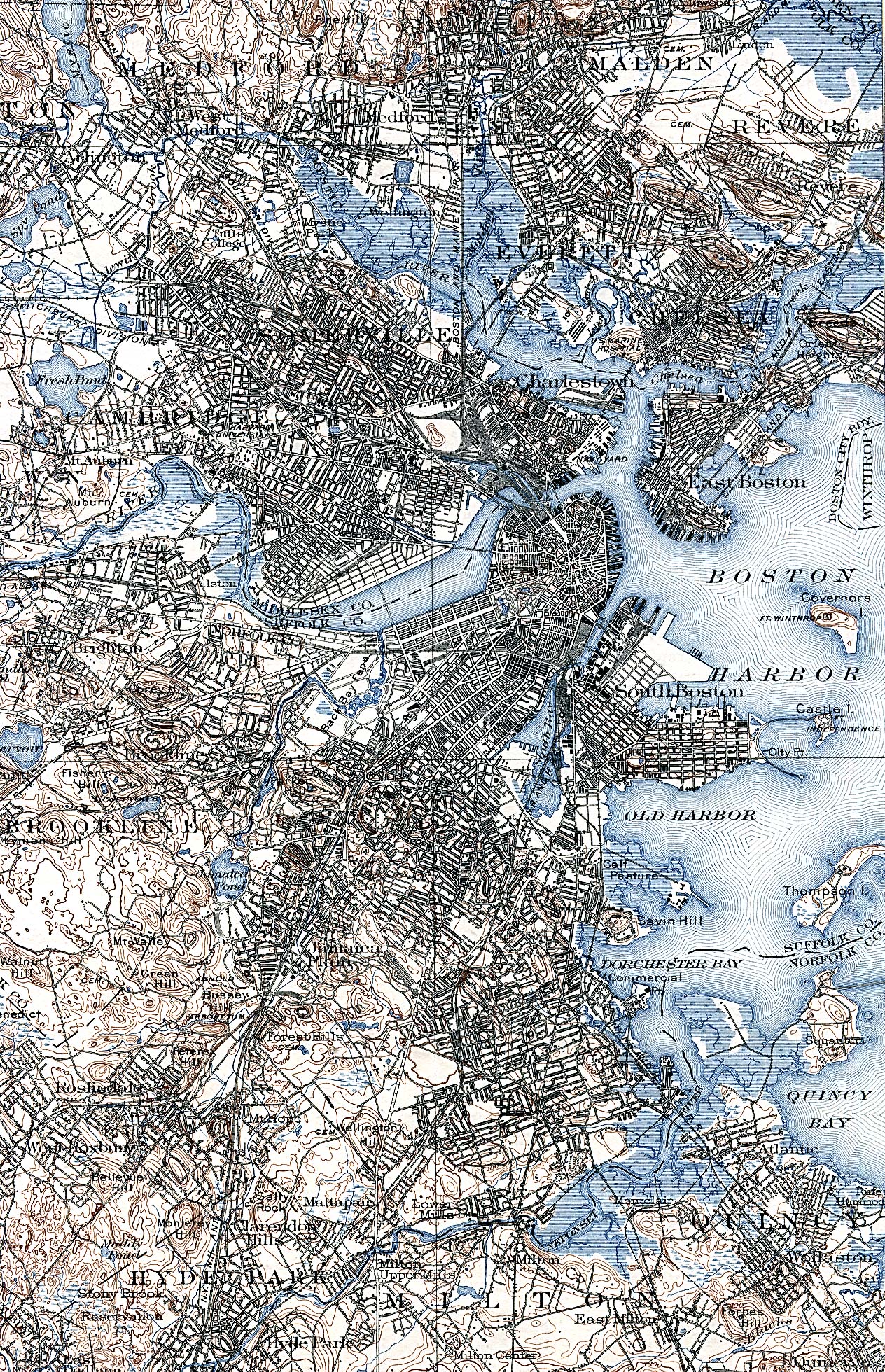
I wouldn’t lose to much sleep worrying about the folks in Boston when it comes to pushing back against the ocean. Excerpts from the following maps were used to make an animation of the changing coastline in Boston:
- A 1775 map showing the Boston area with the rebel military works. Note especially the isthmus, known as Boston Neck< that connects the town of Boston to the mainland.
- An 1838 George W. Boynton engraving of Boston area from a Thomas G. Bradford atlas.
- USGS map of Boston area.
- A 2009 satellite image from Google Earth
The top of the animation shows the maps after photoshopping to make the land and water more obvious. The bottom of the animation shows the unaltered excerpts of the maps or images.

The panic prone will argue that our Bostonian ancestors dealt with a static ocean, not a rising ocean. Not so fast. Check out the NOAA graph below (click inside graph to see it in context at NOAA site). It shows a sea level rise rate of 2.63 mm/yr for the last 100 years in Boston. At that rate it will rise 23.9 cm (9.4 inches) by 2100.

Boston sea level rise data from NOAA. Click in image for view in context.
Anyone who panics over the IPCCs 100 year projections of rising sea levels does not understand the perseverance and ingenuity of free people. Then there are others, like James Hansen, who enjoy the feeling of panic so much that that they exagerate the probable sea level rise for this century to get their thrills. But that is a story for another day…
Boston is an example of what the wealth of free enterprise and a free society can do. Where will we be 10 years from now when all of our industries are left holding worthless carbon credits that they spent hundreds of billions of dollars to puchase? Unlike the dot.com bust there will be no gems like google or yahoo. Unlike the sub-prime mortgage meltdown there will be no real property, while less valuable, that still has value. All carbon credits will be equally worthless. Our economy will collapse and there will be no wealth left to deal with anything that nature throws at us.
200 million people live within 1m of sea level. I wonder how those 200 million feel about your posts.
BTW seems you are back into the habit of filtering posts (guess the near record warm April just reported by NOAA and the fact that we are probably headed for a top 3 warm year was was unhelpful).
So, you’re arguing that all we need to do is use fill to stop the ocean? That works for a small area like Boston — do you have any idea how much shoreline the Mississippi River has? We can’t hold it back now. The Iriwaddy? The Mekong? The Indus? The Thames?
These rivers are all deltas. Do you have any idea why deltas form? Evidently not so I’ll explain it to you. They form because they can’t carry their sediment load with the low water velocity as the fan spreads out when it meets a body of water. So the sediment piles up and blocks river flow, until the velocity increases to match the sediment load. This balance determines the slope of the delta and explains river braiding, meanders, etc. Heavy loads (rock, gravel) high slope, light stuff (organic, silt) low slope, as in the lower Mississippi. As the oceans rise, the deltas rise too, where left in a natural state. If you decide to alter the natural state (limit the ability of water to spread out by channeling the rivers and building), the velocity stays high and sediment is carried out until it meets the water, and gets deposited there, where a new delta will form.
Choosing to build on a delta is obviously a convenient place (since all of the large ones you mention are taken), but you take a risk by altering the natural state. With sea level rising as it has since the last ice age at a slow rate, chances are you built on high enough ground to start with, or you adapt, or you move, or you just live with flooding (most of these will experience flooding on a regular basis). Adapting to 2mm/yr is obviously no big deal though building on a delta generally means it is going to sink without the additional sediment that would otherwise be there, an effect of changing the delta, not sea level rise. Sea level rise will not affect a natural delta unless it rises faster than the sedimentation rate, which seems unlikely given a steady sea level rise rate, and the existence of the deltas you mention, which obviously means in their natural state, sedimentation is faster than rise. In an unnatural case, like New Orleans, light silt and organic deposits mean the sink rate is much higher than sea level rise, so you build dikes. In their case, despite repeated warnings they didn’t plan ahead and keep up with the sink / erosion rate. One small dike failure and you’ve had it. Blame it on the French for failing to account for geology 300 years hence (actually, they built on high enough ground in the French Quarter). Or blame it on climate change, whatever you prefer.
There is no evidence sea level rise rate is anything out of the ordinary. So what’s your beef? That humans chose to build on a delta and altered it so now it can’t rise to meet the ocean while it is sinking? Are we supposed to feel sorry about this?
It is odd to see comments about how much adaptation costs because land reclamation usually makes money as you can either sell the land or find a good use for it. The biggest reclamation project was in the Landes area of France which has made a packet of money:
http://www2.ctic.purdue.edu/Core4/CT/conquest/France.html
Probably couldn’t be done today; there’d be too many claiming that the advancing dunes or the malarial marshes were home to species that must be protected.
In the coastal and delta areas many houses have been built where they should never have been built in the first place. That’s why people face displacement. And it’s getting worse as folk move to the coast in hordes. To protect them, and the environment at the same time, will need Napoleonic thinking. Relying on CO2 mitigation to do anything at all helpful for coastal communities is absurdly simplistic.
Yet it’s cute how people like Dhogaza and a few others here can talk about the cost of coastal protection which will most certainly help both man and the environment, yet ignore the higher costs of CO2 mitigation which demonstrably won’t help the coastline dwellers or the coastal environment. We need to prefer the options that can either make money or prevent money loss.
Ed Darrell (11:37:33) : So, you’re arguing that all we need to do is use fill to stop the ocean? That works for a small area like Boston — do you have any idea how much shoreline the Mississippi River has?
Um
http://www.lacoast.gov/landchange/basins/mr/
we have:
Suspended sediment concentrations in the river decreased markedly between 1950 and 1966. Since that time the observed decrease in the suspended sediment load has been minimal. Long-term suspended sediment loads in the river average 436,000 tons per day; they have ranged from an average of 1,576,000 tons per day in 1951 to a still considerable average of 219,000 tons per day in 1988.
So we changed the amount of dirt washing into the river (probably all those levees and lining the bottom with concrete in some areas) but it still delivers 436 KILOTONS PER DAY of sediment… So it’s not so much about the need for more dirt. What could it be…
The entire area is the product of sediment deposition following the latest rise in sea level about 5,000 years ago. Each Mississippi River deltaic cycle was initiated by a gradual capture of the Mississippi River by a distributary which offered a shorter route to the Gulf of Mexico. After abandonment of an older delta lobe, which would cut off the primary supply of fresh water and sediment, an area would undergo compaction, subsidence, and erosion. The old delta lobe would begin to retreat as the gulf advanced, forming lakes, bays, and sounds. Concurrently, a new delta lobe would begin its advance gulfward. This deltaic process has, over the past 5,000 years, caused the coastline of south Louisiana to advance gulfward from 15 to 50 miles, forming the present-day coastal plain.
Oh… so it’s a natural active process of land formation that has areas deposited, then compacted and eroded…
This delta is located on the edge of the continental shelf of the Gulf of Mexico. Its bird’s foot configuration is characteristic of alluvial deposition in deep water. In this configuration large volumes of sediment are required to create land area; consequently, land is being lost in this delta more rapidly than it is being created.
OH. so the reduction in sedimentation is probably why it isn’t holding up so well… Guess we need to rip out all the levies… and let nature return… Yeah, that worked well with Katrina…
The real problem is building a city on a dynamic deep water delta with subsidence and dynamic “birds foot” channels. Not some kind of sea level thing, since it’s a product of the sea level rise 5000 years ago…
The primary wetlands loss problem facing the Mississippi River Delta Basin is that of subsidence and compaction. Unlike other areas of coastal Louisiana, the Mississippi River delta is blessed with a relative abundance of inflowing fresh water and sediments. Despite the availability of these resources, the overall growth of emergent delta has been truncated in recent history. In its present position the Mississippi River deposits sediments into much deeper water than has been the case historically. This is evidenced by the thick stratum of Holocene deltaic sediments found in the active river delta. These unconsolidated sediments are highly susceptible to compaction, reducing the life span of emergent wetlands. While the rapid emergence of wetlands can occur over large areas in the delta, these areas deteriorate in an equally rapid manner.
Human activities have aggravated land loss rates in the Plaquemines-Balize delta. The stabilization of the Mississippi River’s channel has cut off seasonal sediment-laden overbank flow that once nourished adjacent wetland areas. The Mississippi River levees to the north, and associated erosion control and channel stabilization measures extending to its mouth, also preclude the possibility of a naturally occurring crevasse or change in the river’s course.
Yup. It’s the levies moving all the sediments way out to the end instead of letting them build up the subsiding delta area… In other words, it’s not sea level rise, that MADE the delta. It’s our mucking up the natural deposition of ungodly quantities of sediments and the natural tendency of “new land” from sediments to compact over time.
So the only problem I see is that we need to manage the sediments a bit better… and maybe not build on dynamic alluvial flood plains below / at sea level…
Nasif Nahle (12:06:47) :
I don’t remember where I read that rising of sea levels affect coral reefs. Perhaps it was somewhere from Science magazine pages. It’s a blatant lie because corals grow upwards as sea level rises. They feed on phytoplankton, which growth is determined by the inward photon stream from the Sun, and zooplankton, which depends on the abundance of phytoplankton, so the growth of corals follows the upper layer of the euphotic environment, where phytoplankton and zooplankton grow and develop better. A rising of ~0.007 mm/day is rather adequate for the corals adaptation, which grow upwards ~0.034 mm/day. A real problem for corals would be if the sea level went more than 1 mm/day down.
If corals easily adapt, lacking of science and technology, wouldn’t humans do it?”
Nasif, you are right, we have always adapted and there is nothing to worry about.
Ian Plimer had a nice story about Tuvalu in his climate presentation.
He stated that Tuvalu is sinking because it is on top of an old undersea volcano.
The reason it is still above sealevel is because of the corals that grow on top of the volcano. They make a layer which now is more than 4 km thick.
Darwin already new about what was going on at Tuvalu and published about it in his great book.
All the scare mongering is based on cherry picking, manipulating and bending history and scientific facts.
I am absolutely not worried about our weather nor our climate.
‘Of course, the environmental [opposition] will oppose any attempts, such as jettys, bulkheads, landfill, dredging, levies and dikes to abate coastal changes. Thus making the prophecy self-fulfilling.’
And you will resist, because you’d rather have a mudflat than a beach.
It’s more complex than you guys suppose.
Tom in Florida (12:04:39) & K B Piersen (14:16:12),
Thanks for adding to the discussion about Occam’s Razor. Tom, maybe I should have tried to be more emphatic when I wrote: “…the simplest explanation is almost always the correct explanation.” [my emphasis here]
You’re right, of course, sometimes explanations are too simple. I was only trying to point out that adding another variable like CO2 to the equation is unnecessary, since the theory of natural variability already explains the current climate without taking CO2 — or pirates — into account.
I hate to use Wiki for anything, but according to them: The principle states that the explanation of any phenomenon should make as few assumptions as possible, eliminating those that make no difference in the observable predictions of the explanatory hypothesis or theory. [my emphasis again]
Correct me if I’m wrong, but CO2 makes no observable predictions. The current climate is fully explained as natural climate fluctuations, which are well within historical parameters. I accept that CO2 probably has some minimal effect at current concentrations, but without observable predictions [a rise in CO2 causes the global temperature to rise], then Occam’s Razor says the unnecessary variable should be discarded.
[The climate alarmists also fall back on the argumentum ad ignorantiam: the fallacy of assuming something is true [eg, that CO2 causes runaway global warming], simply because it has not been proven false. I only mention this because I like the ignorantium part.]
Nasif Nahle (13:05:08) :
No, no… it was not from Science magazine, but from Springer LinK:
Fortunately history NEVER remembers that kind of “scientists”. If we revise science history all breakthroughs have been made by gifted individuals, Those “clerk-scientists ” paid by governments everywhere are doomed to oblivion.
Neven (13:21:02) : After how many inches of rise does it become too costly to defend the entire coastline?
According to my wife, 6 inches …
“Believe those who are seeking the truth. Doubt those who find it.”
Andre Gide
dont forget the Kansai airport, it was built entirely on a man made island, mostly because of protests from environmentalists.
http://www.sjsu.edu/faculty/watkins/kansaiairport.htm
lichanos (14:00:32) : It’s a different business to respond to sea level changes in an 18th and 19th century city while it’s growing than to retro-fit a built out 20th century city with all of its infrastructure to new sea conditions.
You mean like 20th century Galveston already has done?
http://www.galveston.com/seawallphotos/
Regarding the land reclamation project in the Landes area (the Napoleonic venture that continues to make heaps of money while protecting the environment, rebuilding the forests and and protecting the inhabitants) I was curious as to what causes the dunes to impinge on the land and i found this:
http://hol.sagepub.com/cgi/content/abstract/12/2/231
“Sand invasion is driven by an increase in frequency of severe storms in the North Atlantic associated with the cooler periods of the ‘Little Ice Age’ and early ‘Mediaeval Warm Period’. The dunes emplaced 900-1300 years ago were naturally fixed by a mixed deciduous and maritime pine forest during the latter part of the ‘Mediaeval Warm Period’.”
ie the storminess caused by the cool period caused land loss which was reversed by the later warmer, less stormy period. Adding that finding to the Sahara shrinking, the natural land reclamation in Bangladesh and the overall greening of the planet in our recent warm period, warming very often seems to have the opposite effect from the doomsayers predictions. Nature is a lot more complex than some people like to believe and it just loves warmth.
Speaking of Occam’s Razor:
The “CO2” explanation seems to me the most simple… and yet it’s definitely not correct.
Imagine how much cheaper it is to push dirt into the ocean than the alternatives being proposed. Sea level has been rising my entire lifetime, and all of modern history. Building cities at sea level made sense when shipping only involved ships, but has slightly less importance today. Building cities on major rivers used to make sense too, other than a water supply we don’t need to do that anymore.
We are humans. We change the environment to suit ourselves… this is why we have furnaces and air conditioning in our homes and businesses. Most places outside of the equatorial zone would be uninhabited by humans if we didn’t. I have a hard time believing that dealing with small regular sea level rises has to be any different. (disclaimer: I live at 3500 feet and am a 12 hour drive from the nearest ocean… sea level rise will never have a direct effect on me)
Well, we may be able to control our greenhouse gases – to some extent at least – but it is unlikely that we will ever be able to affect the earth’s geodynamics. I like Professor Dietmar Müller’s big picture from the School of Geosciences at the University of Sydney that in 80 million years time there will be an unstoppable 70 metre net FALL in sea levels. Might be digging all that Boston fill out by then to get to the docks:
http://www.usyd.edu.au/news/84.html?newsstoryid=2187
In Australia Robyn Williams a scientist and science reporter with Radio National – a public radio station funded by government like the BBC – also like the BBC at the forefront of AGW alarmism. Williams – designated a national living treasure, has reported that runaway AGW will cause sea levels to rise by 100m. He is now parodied as Robyn 100m Williams but still maintains a strong line on global warming along with self appointed climate guru Tim Flannery. My hope is that we soon have a reality check on this nonsense.
Quite interesting that the CAGW crowd always, in the UK, point to East Coast erosion as evidence of the coming apocalypse but always neglect the West Coast where new land forms at an alarming rate. Time and Dirt indeed.
Excellent description – except that they seem to have been reduced to attacking the barn with an aircraft mounted M60/1 type weapon and spraying the paint through a high pressure hose. Eventually some of it looks like a bulls-eye if you squint and angle your head the right way. Modern Art.
The deposition of sediment in the delta is also acclerated by the ocean salinity that destroys the clay colloidal suspension in the river water. For this reason most of the clay particles settles close to the sea/ river interfce rather than farther out in the sea. If global warming will results to more storms, flooding and erratic weather patterns, it will accelerate the weathering of rocks and increase the erosion rates to the deltas. As far as the big river deltas mentioned, human deforestation and land use change up stream of the deltas is increasing erosion and sediment loads. However, the building of dams and river dredging upstream to control flooding is reducing the sediment load. It is a complex mechanism to be simply blamed on global warming.
However, global warming has become a good and easy reason for most bureaucrats who are too lazy to do anything or are just simply ignorant. I was horrified once watching a TV in a developing country where an outbreak of dengue fever was staking place. Control of the mosquitoes vectors has been a proven and effective method to control but the health minister just replied “I am sorry there is not much we could do. It because of gobal warming”
U.K. readers here will know of the Archeological TV show – Time Team.
A group of archeologists in concert with a film team do a three day dig on sites of interest.
Time and time again the team have shown altered coast lines, altered river directions and flows rising and falling landscapes etc etc. They use ancient maps and drawings to illustrate their findings.
What it does prove is that over the millenniums, coast lines and escarpment are constantly changing and evolving and that the humans just adapt to this.
I have posted before the fact that due to tectonic effect the Australian continent is moving towards the Pacific in a lateral North east direction at 7cms per year. This is 7 meters in a century. This doesn’t take in account the rises and falls of the land mass. Who knows what effect any sea level rise will have in concert with this movement. The Great barrier reef is moving with the continent. It has been there for many thousands of years – and will be for many thousands of years to come.
Very enlightening! Thanks.
Putting him on your blog roll might be a worthless exercise, though. It appears he hasn’t posted since April 18, 2009. He posts as slow as the sea levels rise.
Les Francis (17:24:45),
Mrs. Smokey and I just returned from the U.S. Geological Survey located in Menlo Park, California [about 20 miles south of San Francisco]. The USGS is having its annual open house this weekend. The amount of information they provide is astonishing. Check them out at: http://www.usgs.gov Their maps are fantastic and inexpensive, courtesy of the U.S. taxpayer.
One of the displays showed that the average movement of fault lines is 22 mm a year [some less, some much more]. That is a lot more than the sea level rise, which is ±3 mm/year.
Some of the tectonic plate movement is toward the ocean, some is away, some is subduction, etc. With so much geological shifting, it’s likely that the changes affect the measurement of the sea level. We still have a lot to learn about land/sea interaction.
One of the more interesting settlements in the UK is Skara Brae (Orkney’s). Dated to about 3000 BC or so and really well preserved. It seems to be generally accepted that the settlement was abandoned after a couple of thousand years once the locals realised that the climate would never change and they were just hopelessly trapped on a “Hockey Stick” with no sign of relief.
Either that or the climate turned really cold up there and food became scarce – never sure which as I get my news from the BBC.
Smokey (15:56:38) : “Tom in Florida (12:04:39) & K B Piersen (14:16:12),
Thanks for adding to the discussion about Occam’s Razor.”
Sorry if I came across too strong. It is just that I have heard the Occam’s Razor quote far too often as “proof” that simple always wins.
As CodeTech (16:14:30) said: ” Speaking of Occam’s Razor:
The “CO2″ explanation seems to me the most simple… and yet it’s definitely not correct.”
I started down the road to learning about AGW precisely because someone used Occam’s Razor to argue that CO2 was the cause of global warming. It seemed too simple to me at the time and then I learned that Al Gore was involved and well, that made me a skeptic right away. So here I am, much more informed on a whole lot of stuff with a revived interest in looking things up, all due to visiting this blog.
Can we say “thanks and great job” to Anthony et al too often? I think not.
John Wolf (13:06:12),dirt can be moved ‘naturally’ given enough time and thoughtless removal of riverbank growth. The ancient city of Ephesus in Turkey was near the sea in Greek times but a silting up of the river over one thousand years plus has changed all of that.
http://www.longpassages.org/images/Turkey%20Ephesus%20view%20of%20boulevard.jpg