 This post on sea level reality came up in comments, posted by the author of the Climate Sanity website, Tom Moriarty.
Tom did an excellent job of visually illustrating the history of Boston Harbor and man’s plight in dealing with it, so I thought it would be worth sharing here for WUWT readers. In fact I’m so impressed, I’ve added Tom to the WUWT blogroll.
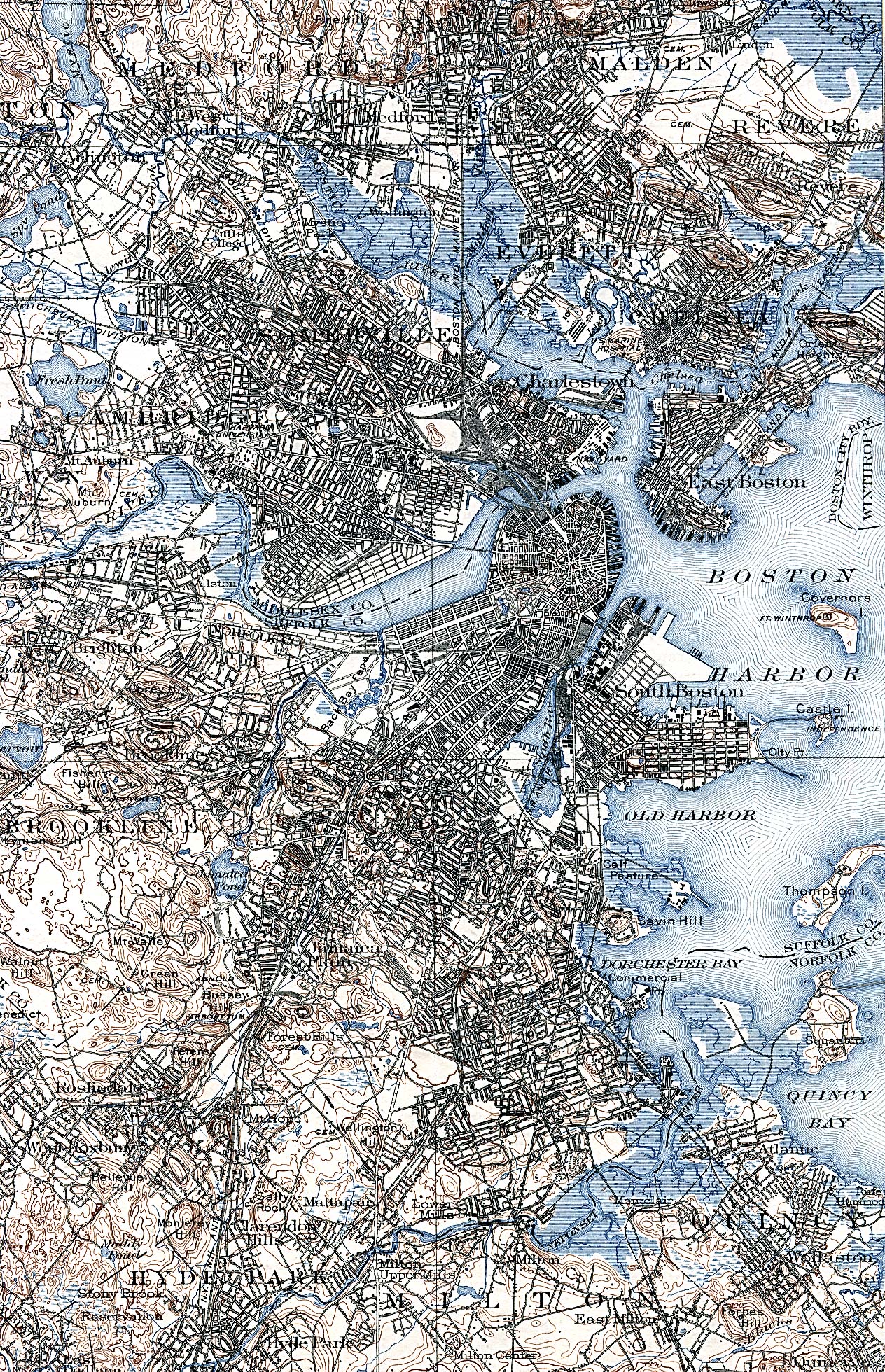
Of all the talk about sea level rise, it is interesting to point out that at least in Boston, man has easily outraced the sea. The worry about sea level is real, but the ability of man to adapt is clearly illustrated in the comparative maps. Just a note, I’ve modified the original blink comparator animation to make it a bit easier to watch. – Anthony
From Climate Sanity:
Boston, you have been warned. Sea levels are rising , and if one of the IPCC’s five scenarios is correct, the world’s oceans will rise somewhere between 18 and 59 cm (7 to 23 inches) by 2100. If that isn’t terrifying enough for the people living on the New England coast, the Boston Globe now tells us that the ocean near Boston will rise 8 inches more than the world average. How will the hapless rubes of Boston cope with this onslaught of Atlantic water?
I wouldn’t lose to much sleep worrying about the folks in Boston when it comes to pushing back against the ocean. Excerpts from the following maps were used to make an animation of the changing coastline in Boston:
- A 1775 map showing the Boston area with the rebel military works. Note especially the isthmus, known as Boston Neck< that connects the town of Boston to the mainland.
- An 1838 George W. Boynton engraving of Boston area from a Thomas G. Bradford atlas.
- USGS map of Boston area.
- A 2009 satellite image from Google Earth
The top of the animation shows the maps after photoshopping to make the land and water more obvious. The bottom of the animation shows the unaltered excerpts of the maps or images.

The panic prone will argue that our Bostonian ancestors dealt with a static ocean, not a rising ocean. Not so fast. Check out the NOAA graph below (click inside graph to see it in context at NOAA site). It shows a sea level rise rate of 2.63 mm/yr for the last 100 years in Boston. At that rate it will rise 23.9 cm (9.4 inches) by 2100.

Boston sea level rise data from NOAA. Click in image for view in context.
Anyone who panics over the IPCCs 100 year projections of rising sea levels does not understand the perseverance and ingenuity of free people. Then there are others, like James Hansen, who enjoy the feeling of panic so much that that they exagerate the probable sea level rise for this century to get their thrills. But that is a story for another day…
Ed Darrell,
Dr. Nils Morner notes the satellite record shows little/no consistent pattern of sea rise when considering the entire globe. No more than 1.1mm/yr. Some shorelines are subsiding, some uplifting.
http://www.larouchepub.com/eiw/public/2007/2007_20-29/2007-25/pdf/33-37_725.pdf
Don’t we need some continental ice to melt or seas to rise before we run for the lifeboats?
IF the moon had a RAPIDLY decaying orbit, it WOULD eventually collide with earth. I’m just guessing, but I’m pretty sure this would be bad. But when we measure this, and see it is drifting away, why would we spend trillions to plan for an impending collision?
http://www.space.com/scienceastronomy/moon_mechanics_0303018.html
Ed Darrell (11:37:33) :
So, you’re arguing that all we need to do is use fill to stop the ocean? That works for a small area like Boston — do you have any idea how much shoreline the Mississippi River has? We can’t hold it back now.
The shoreline of the Mississippi is 100% above sea level, and will continue to be. But where is your concern for areas already below sea level – Death Valley, the Dead Sea, Holland. If the sea level rises, they’ll all go under, won’t they? (/sarc)
Global Warming Art put up a map of Florida depicting the areas endangered by sea level rise. Their color choices are what we’ve come to
suspectexpect from the AGW crowd, but I’ve highlighted the actual areas that would go under after a millennium of rise at the current rate. Their data, real rate.http://i41.tinypic.com/qx8hmw.jpg
There are several places in Kent and Sussex that used to be on the coast 1000 years ago and ain’t now.
In the area of the east coast of England called Holderness (about from Bridlington down to the River Humber) coastal erosion is regularly toppling people’s holiday cottages over the cliff edge. Eventually the coast will erode as far as Beverley or thereabouts where (if it’s lucky) it’ll find some rock to stop it!
Neither have much to do with global warming or sea rising or falling; everything to do with wind and wave and the geological structure of the area.
Not easy to extrapolate when places barely 200 miles apart are behaving in precisely opposite fashion, wouldn’t you say?
No, no… it was not from Science magazine, but from Springer LinK:
http://www.springerlink.com/content/pg2542jv25144t78/
Sung to the tune of “Let’s fall in love”:
Mesopotamians did it, Romans did it, even ignorant Anasasi did it. Let’s do it, let’s move some dirt..
Moving dirt is easy, and easily understood, and cheap especially when it’s done to keep commerce flowing. It is part of the cost of doing business. Just ask the Caterpillar Company.
Just wait till the 1938 hurricane the hit NYC repeats.
According to the United States Landfalling Hurricane Probability Project:
16% probability that NY City/Long Island will be hit with a tropical storm or hurricane in 2009. Normal value is 15%.
10% probability that NY City/Long Island will be hit with a hurricane in 2009. Normal value is 9%.
5% probability that NY City/Long Island will be hit with a major hurricane (category 3 or more) in 2009. Normal value is 4%.
>99.9% probability that NY City/Long Island will be hit with a tropical storm or hurricane in the next 50 years.
99.4% probability that NY City/Long Island will be hit with a hurricane in the next 50 years.
90% probability that NY City/Long Island will be hit with a major hurricane (category 3 or more) in the next 50 years.
http://www2.sunysuffolk.edu/mandias/38hurricane/hurricane_future.html
” rbateman (11:41:26) :
The trucks are busy, busy, busy filling in those shallows to make more city.
Heck, they even made new islands somewhere in Saudi Arabia just because they had the money to do it. Landfill is big business. Just don’t plan on getting your Earthquake insurance settlement when your building gets sucked into liquified goo when the big one hits.”
The big what? Boston is not on or near any fault lines or volcanic subduction zones. Sorry, those of us outside the left coast do not make a habit of investing billions in buildings in tidal zones over tectonic faults. Boston has been around for over 350 years.
Most of the land in Boston was created prior to the 20th century, when fill (Beacon Hill was once very tall, its now rather flat today, most of it is in the back bay) and labor were cheap and there was a notable lack of environmental impact statements or tree-huggers. If Massachusetts politics back then was like it is now, there would be huge bumper to bumper traffic jams on the Boston Neck and the Kennedys of their time would be filing lawsuits to prevent the city from devaluing the waterfront properties along the back bay.
“Anyone who panics over the IPCCs 100 year projections of rising sea levels does not understand the perseverance and ingenuity of free people.”
At what cost? And where will the money come from? After how many inches of rise does it become too costly to defend the entire coastline? Is it actually possible that people will be less free because of something like rising sea levels?
I used to live 10 meters below sea level in the Netherlands, in a place that had been several meters under water 200 years earlier. It’s impressive what the Dutch have accomplished in claiming land from the North Sea. But claiming land and resisting a reclaiming ocean are quite different. Did one of you ever try to defend your sand castle with a rising tide? Costs a lot of energy.
Ed Darrell (11:37:33) :
So what is your point?
the point is that sea level isn’t constant and modern humans have adapted to considerable sea level rise in the past. Why should that change?
How can we stop it? And don’t tell me it has anything to do with CO2.
MikeEE
Polar Bears not welcome in Iceland
—————————————————————
Einmana og villtur hvítabjörn
http://www.mbl.is/mm/frettir/innlent/2008/06/03/einmana_og_villtur_hvitabjorn/
Ed Darrell (11:37:33) :
So, you’re arguing that all we need to do is use fill to stop the ocean?
Reading comprehension 101: First, read the article. (Hint: it’s about adaptation, using Boston as an illustration).
Man has always managed to adapt to climate change before, and has a myriad of ways of doing so now. Crying, screaming and wailing about it don’t work.
Building in flood-prone areas, the opposite of adaptation is just plain dumb, as is blaming “carbon”.
Is the U.S. Surface Temperature Record Reliable?
by Anthony Watts
SurfaceStations.org
http://static.cbslocal.com/station/wbz/wbz/2009/may/SurfaceStations.pdf
We observed that changes in the technology of temperature stations over time also has caused them to report a false warming trend. We found major gaps in the data record that were filled in with data from nearby sites, a practice
that propagates and compounds errors. We found that adjustments to the data by both NOAA and another government agency, NASA, cause recent temperatures to look even higher. The conclusion is inescapable: The U.S. temperature record is unreliable.
The cost of building sea walls will be minor compared to the never ending cost of a world wide tax on CO2, a gas harmless to the environment, necessary for life and vilified by the looney greenies. BTW, I wonder what the percentage of CO2 exhaled by humans is compared to industry’s contribution?
Neven (13:21:02) :
“Anyone who panics over the IPCCs 100 year projections of rising sea levels does not understand the perseverance and ingenuity of free people.”
Neven, let me help you with some answers to your questions:
Q: At what cost? And where will the money come from?
Your taxes, of course! You can help ratify an new coastal sea rise tax – payable when you visit a beach anywhere in your country. Make sure rich people pay a lot!
Q: After how many inches of rise does it become too costly to defend the entire coastline?
Exactly 15.781 inches. Unfortunately, none of us will be here to see if this is true or not, given the paltry rate at which the sea is currently rising…
Q: Is it actually possible that people will be less free because of something like rising sea levels?
No. People will be less free when their governments impose draconian laws and taxes to manage every aspect of their behavior, from where they can live to what they can eat and how many children they can have, in response to a fictional problem (AGW)…
Well, yes, the “panic” is totally misplaced. That is, if the predictions are even reliable.
On the other hand, the animation, though fascinating, is a bit misleading. It’s a different business to respond to sea level changes in an 18th and 19th century city while it’s growing than to retro-fit a built out 20th century city with all of its infrastructure to new sea conditions. In addition, though retreat and rebuilding on higher ground is often the simplest, and not-to-hard solution, politically it’s a killer. This often leads to less than optimal solutions, e.g. sea walls, that can make the problems worse!
Analogies to Holland are also not relevant. Holland has little land, lots of people, and no where to go except to the sea. If the dikes break, the nation disappears. Hardly the same here in the USA. They have reasons to worry deeply about any sea level rise, and still, they seem to do okay.
And if you live in NYC and are worried about another hurricane like the one in 1938…http://www.halcrow.com/html/documents/pdf/noam/NY_NJ%20Outer_Harbor_Gateway.pdf
I love the it’s too expensive to defend against sea level rise posts, even though Boston for example did not institute a nationwide tax on energy to fill the harbour, but instead through commercial activity and time simply expanded the city and the harbour to protect itself.
Is that not part of the argument against carbon taxes? Cost versus results. Did filling Boston Harbour Cost 3% of World GDP for the next 200 years for Example? (based on 2005 GDP not todays)
Mike McMillan:
Oh, that’s right — I’d forgotten the Bush administration’s effort to fill in New Orleans and elevate it 20 feet, like the Galveston Islanders did after the 1900 hurricane. /sarc off
All shoreline is above sea level, Mike. When sea level rises, so does the shoreline. It’s the land that gets covered by water we worry about.
My point is that much of the shoreline of the Mississippi and its current delta are threatened by rising ocean levels. Unless one has had to deal with communications, or oil and gas pipelines, or bird conservation, or hunting, or fishing, or keeping one’s house dry, or unless one reads the newspapers, I suppose one wouldn’t know.
From the “feeling of panic” link in the article:
“In 1988, Hansen launched global warming as a public policy issue in his testimony before a congressional committee. Theon admitted that he actually couldn’t have fired Hansen, who had powerful political protectors, most notably then-Senator and later Vice President Al Gore. So had Theon tried to do it, it’s much more likely that he himself would have been out on the street rather than Hansen.”
Interesting point he makes… So AlGore was part of the process that gave us the first panic… and was a protector of Hansen from the start… Hmmm.
And NASA management was well aware of the political landscape and making politically driven rather than science driven decisions out of a sense of self preservation (hey, I can relate… I’ve worked in politically dominated organizations before; it would have been organizational suicide not to “go along to get along”. The base fault is to let the organization become politically dominated in the first place. Above Theons’ pay grade…
Theon told the audience that while he remained silent on the issue of global warming when he retired from NASA, he now felt he needed to speak out. “This whole thing is a fraud,” said Theon. “We need to educate the public about what we’re going to get into unless we stop this nonsense.” The nonsense being the deleterious effect that carbon rationing would have on economic growth and jobs.”
Love that quote… “fraud”… at least someone has clue.
BTW, Anthony, if after the BRACKEThttp=QUOTElinktextQUOTE part of the link, you put QUOTEtarget=QUOTE UNDERSCOREblankQUOTE then the link will open in a new window rather than leaving WUWT. For folks, like me, on slow links; it lets us open the window and leave it loading while we swap back to the WUWT page to keep reading your article… A nice feature (even if it does take a bit more time to type the target=”_blank” part…
Also, here on the Loony Left Coast, we have the same problem in San Francisco bay where we are simultaneously told that the bay is going to rise and flood every one AND that the bay is going away due to silt accumulation and landfill… The “port of Alviso” built and launched small warcraft for WWII… Today it’s a marsh on the way to becoming a meadow. The government put in nice sail boat docks about 1980? or so (and you could rent sailboat space). Now, with no dredging, they are locked up and abandoned as a large reed patch becoming land…
It would make an interesting “photo essay” on “sea level rise” 😉
Ed Darrell (11:37:33) :
Alluvial plains. Continuously growing and changing. In regards to the Mississippi Delta one of the greatest impacts is from flood control up river and dredging which removed sediment from the river. Dredging prevents sediments from finding their way down to the delta which would naturally reinforce and expand the alluvial plain. It also tends to help keep the river following its current course.
Historically the Mississippi has been a freely roaming river. Each time it changed courses the cutting of new channels / routes increased the amount of material carried down to the delta. This map illustrates part of its history…
http://geoscience.wes.army.mil/LMValleyGeologyMap.JPG
Hence, a good part of the problem with the delta, the alluvial plain, are not so much from what the oceans are doing as much as from what man is doing to the river itself. Call it just one example regarding the consequences of man’s intervention with nature. Sometimes we need to for our own convenience, other times we don’t.
When it comes to alluvial plains man is occupying land which, in geological terms, is not very old nor very stable. It is still a work in progress and changes to it both in gains and loses should be expected. Such is the path of nature.
As humans we tend to think of the world in terms of a generation or two due to the fact that our live span is relatively short. It is essential that man learns to adapt to nature and climate changes. With some level of admitted uncertainty I don’t personally feel that man will be experiencing any significant increases in sea levels. However, with a great deal of certainty I will say that at some time in the geological near future our present day harbors and ports will be inland locations. Sea levels will drop more than 400 feet. Galveston Bay (7 -15 feet deep), and other locations, will quickly become dry land. At those times, man being man, will build upon, live upon, and develop them. When nature once again reclaims those lands and places them within the seas (about 60-80,000 years later) hopefully there will not be an Al Gore type around attempting to blame man for it.
Tom in Florida is worried about a misstatement of Ockam’s Razor –
“I can not longer let this misconception pass. Occam’s Razor does not mean what you state here. It means that the simplest CORRECT explanation is always the BEST explanation. It does not guarantee that the simplest theory will be correct.”
I am not sure that this distinction is necessary. I have always taken it to mean that, given two explanations, either of which might be correct, the explanation requiring the least number of assumptions/causal factors/ etc etc, was likely to be the most efficacious.
This formulation basically takes both explanations as at least possibly ‘correct’ and draws a pragmatic conclusion as to which to accept.
Note that if you require that it is only the ‘simplest correct’ explanation that should be taken, then Occam’s Razor loses much of it’s power since it is itself being postulated as a means of sorting the correct from the incorrect.
If you require the proposition to be correct before you apply Occam’s Razor to determine whether or not it is correct….. well you can see the possible circularity.
Having said all that, nevertheless Tom is right …. the application of Occam’s Razor does not guarantee that any particular proposition is in fact correct. As I mentioned, it is really a ‘rule of thumb’ which can guide the pragmatist in considering competing explanatory propositions.
Oh what the heck:
Alviso Then: http://www.powells.com/biblio?isbn=9780738531403
and the “Marina” now:
http://www.flickr.com/photos/suprada/3198801690/in/photostream/
Man that sea level rise is a killer …
AndyW (10:56:13) : Tell me how much money it cost Boston to reclaim that much land and what the total cost is for the affected coastal regions of the world.
It was most certainly profitable for them. Landfill is one of the cheapest ways to get land with the most value that one can imagine. There is always someone digging a basement garage somewhere and you can often even get “tipping fees” for the dirt “disposal”. There IS always someone tearing down a concrete structure somewhere and you absolutely can get tipping fees from them.
In San Francisco bay, there are strict laws prohibiting it under most circumstances; since if left to a cost driven market, the bay would become a few hundred foot wide river in no time flat. (Not hyperbole, we were well on our way to that point, which is why the laws were passed to prevent or drastically reduce more bay fill…)
It is almost irrelevant cost. Moving an acre of dirt 10 feet deep is nothing compared to the $100,000 or so minimum per 1/8 acre parcel. (Most of the bay is less than 10 feet deep. The “shipping channel” in the middle is kept dredged to about 30 – 40 feet deep, but that’s just a big river in about 1/2 the middle.)
A few comments from above:
“No one claims that we can’t protect infrastructure or move cities inland as sea levels rise. The claim is that it will be *expensive*, and the example of the Thames flood gates doesn’t seem to support any claim that it’s *cheap*.” If you think these type of projects are expensive, just wait til you see the bill for cap and trade which will have zero effect on sea levels.
“At what cost? ”
Much much less than taxing the air we breathe and turning us back to the 1820s.
“And where will the money come from?”
Well, there won’t be any money at all unless we get back to capitalism.
“After how many inches of rise does it become too costly to defend the entire coastline?”
It will always be cheaper to attack the real problem than to attack a phantom.
“Is it actually possible that people will be less free because of something like rising sea levels?”
Nope. People will be less free with out-of-control governments than they will be with a changing climate.
I know it’s not Boston, but I know more about SF… and it’s still a decent example. From:
http://www.bay.org/about_the_bay.htm
“San Francisco Bay covers 400 square miles with an average depth of 14 feet with depths plunging to 360 feet at the Golden Gate. The Bay has shrunk by a third in the last 150 years, and only about 25 percent of its original wetland, riparian, and tidal mudflat habitat remains. ”
So much for “sea level rise” as an issue.
For the terminally technical, you can get bathymetry data here:
http://sfbay.wr.usgs.gov/sediment/sfbay/index.html
From the wiki (at least, what it says today… who knows how soon the PC Police will “fix it”…):
San Francisco Bay’s profile changed dramatically in the late nineteenth century and again with the initiation of dredging by the US Army Corps of Engineers in the twentieth century. Before about 1860, most bay shores (exception: rocky shores such as those in Carquinez Strait, along Marin shoreline, Point Richmond, Golden Gate area) contained extensive wetlands that graded nearly invisibly from freshwater wetlands to salt marsh and then tidal mudflat. A deep channel ran through the center of the bay, following the ancient drowned river valley.
In the 1860s and continuing into the early twentieth century, miners dumped staggering quantities of mud and gravel from hydraulic mining operations into the upper Sacramento and San Joaquin Rivers. GK Gilbert’s estimates of debris total more than eight times the amount of rock and dirt moved during construction of the Panama Canal. This material flowed down the rivers, progressively eroding into finer and finer sediment, until it reached the bay system. Here some of it settled, eventually filling in Suisun Bay, San Pablo Bay, and San Francisco Bay, in decreasing order of severity.
By the end of the nineteenth century, these “slickens” had filled in much of the shallow bay flats, raising the entire bay profile. New marshes were created in some areas.
[…]
In the last years of the nineteenth and first decades of the twentieth century, at the behest of local political officials and following Congressional orders, the US Army Corps began dredging the Sacramento and San Joaquin Rivers and the deep channels of San Francisco Bay. This work has continued without interruption ever since, an enormous federal subsidy of San Francisco Bay shipping. Some of the dredge spoils were initially dumped in the bay shallows (including helping to create “Treasure Island” on the former shoals to the north of Yerba Buena Island) and used to raise an island in the Sacramento-San Joaquin Delta. The net effect of dredging has been to maintain a narrow deep channel – deeper perhaps than the original bay channel – through a much shallower bay. At the same time, most of the marsh areas have been filled or blocked off from the bay by dikes.
In other words: It is profitable to make land by “fill” due to the need to dredge for shipping (since if you don’t do it, erosion eventually fills in bays…)
The notion that oceans will rise and drown our ports and bays is just seriously broken. The reality is that even with historic sea level rise, our bays fill in with silt and become dry land if we don’t work at it, very hard, to keep them as bays. Geology works that way…
GAK!
The wiki quote continues down to “In other words” where my comments begin…