Guest post by Bill Illis
We have often wondered what really causes the El Nino Southern Oscillation (ENSO) climate pattern. It is generally understood and this post will demonstrate that it is really driven by the Trade Winds over the ENSO region.
The Trade Winds blow East to West at the equator. Most of us living in other latitudes expect the wind and the weather to primarily come from the West but, at the equator, the weather comes from the East.
When the Trade Winds are stronger than average for a sustained period of time, the Trades literally blow or drag the warm surface water across the Pacific and it is replaced by colder upwelling ocean water from below. If the Trades are strong enough for a long enough period of time, we have a La Nina.
When the Trades are weaker than average for a long enough period of time, the ocean surface stalls in place and gets heated day after day by the equatorial Sun and we have an El Nino. Sometimes, this stalling even results in warmer ocean water from the Western Pacific moving backwards into the Nino region and this also contributes to El Nino conditions.
Let’s look at the data to see how true this assertion is.
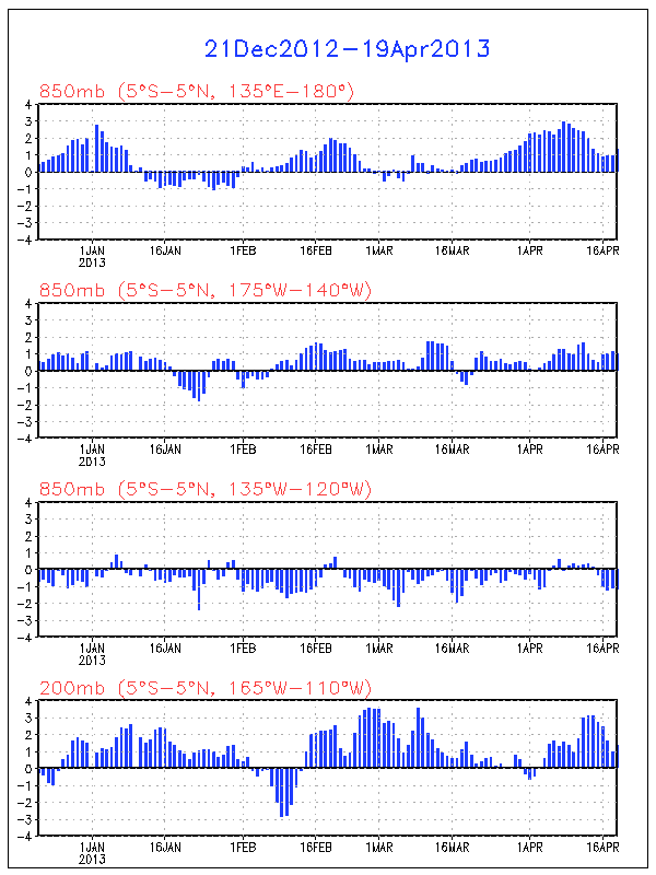
Here is a chart of the Nino 3.4 region temperature anomaly (which is the most consistent measure of ENSO conditions) versus the Trade Winds from 120W to 175W. The Trade Wind data is for 850 MB pressure or about 3,000 feet.

Click for a larger image
To see this correlation a little better, I’ve reversed the sign so that weaker Trade Winds are shown as positive values and stronger Trade Winds are shown as negative values. I’ve reduced the anomaly in meters per second by half as well so the scale is roughly the same as the ENSO.

Click for a larger image
I can’t imagine seeing a better explanation of what drives the ENSO than this.
For some perspective on the Nino regions and the latitude, longitude figures in question here, this is a map of the region produced by the Climate Prediction Centre.

I think you can see this impact in action if you watch an animation of the ENSO region over time. Let this SST anomaly animation load up, then speed it up as fast as your computer will allow and you can see the Nino region waters and temperature anomalies literally move across the Pacific with the Trades.
http://www.osdpd.noaa.gov/PSB/EPS/SST/anom_anim.html
But what drives these Trade Winds? I don’t really have an answer for that question.
The Southern Oscillation Index (SOI) was previously used as an indicator of these winds over the Nino regions. The SOI is a measure of the difference in air pressure between Tahiti and Darwin, Australia. The theory being that high pressure blows toward lower pressure which can provide some indication of the Trade Winds in the Nino region. There is certainly a correlation of this measure to the Nino 3.4 anomaly. In fact, the measure even lent its name to the ENSO.
I’ve found, however, the SOI consistently lags a little behind the Nino region temperatures and the Trade Wind measures so I believe it is more a result of the overall climate pattern rather than a leading indicator. I’ve also found no real correlation to the Pacific Decadal Oscillation or any of the other Oscillation Indices which are sometimes used to predict or measure the ENSO.
There is one leading indicator, however, which provides some predictive power – the Trade Winds just to the West of the Nino area. These Winds are, most often, concurrent with the Nino region Trade Winds but occasionally, they provide a ramp-up which might kickstart the ENSO. The West Trade Winds were a leading indicator of the Super El Ninos of 1982-83 and 1997-98 for example.

Click for a larger image
Unfortunately, I don’t know what drives these Western Trade Winds either, but they are currently pointing to a strengthening of the La Nina conditions which currently exist.
I also wanted to show more closely how the ENSO impacts global temperatures.
The warm or cold ocean conditions of the ENSO eventually impact the Tropics troposphere temperatures and this seems to be quite a direct impact with a lag of 2 to 3 months.

Click for a larger image
The Tropics temperatures then propagate out to the rest of the world with a small lag that may be up to 1 month but is more commonly concurrent with the Tropics anomalies.

Click for a larger image
The Trade Winds drive the ENSO, and the ENSO directly impacts the Tropics temperatures and the Global temperatures.
Who would have thought that Winds in some small region of the Globe could be so important. You can keep track of these Trade Winds on a daily basis at the Climate Prediction Centre.
http://www.cpc.ncep.noaa.gov/products/precip/CWlink/daily_ao_index/zw/zw.obs.gif
So, I think that provides a nice perspective on the ENSO.
The data used in this post can be obtained here.
http://www.cpc.ncep.noaa.gov/data/indices/
http://www.cpc.ncep.noaa.gov/data/indices/sstoi.indices
A short time back Erl predicted la nina conditions petering out around may and a weak el nino building mid year. Do you still go with that Erl?
The GHGs sends some of the long-wave radiation back to the surface, heating it up some more, adding to the heating.
“If oxygen and nitrogen absorb heat, then clearly they radiate heat. What I conclude is that our air is heated without the help of GHG’s or without a molecule requiring 3 atoms. I am not saying that GHG’s do not add to the heating, but I believe it is impossible for CO2 to have a “significant” impact on heating the remaining 99.9% of our atmosphere.”
Rich, you were on the right track. All real materials have differing rates of energy absorption and emission given as a fraction of Einstein’s ideal black body.
Green leaves emit 94% as readily, snow 84%, pure water 58%. CO2 emits/absorbs at 0.09% at sea level and 20 degrees C. Yes, no typo.
Energy flow is therefore one way only, up and out. Of the radiation GHGs absorb they give up the energy acquired via conduction to their neighboring molecules in collisions.
And this is also the way air transfers energy to the surface only by conduction, when it is warmer than the surface. On a water planet, most heat transferred from the surface is removed via evaporation, the heated air rising via convection.
gary gulrud (08:20:02) :
“The GHGs sends some of the long-wave radiation back to the surface, heating it up some more, adding to the heating [of the surface].”
Energy flow is therefore one way only, up and out. Of the radiation GHGs absorb they give up the energy acquired via conduction to their neighboring molecules in collisions.
Note the 333 W/m2 back radiation going down:
http://www.windows.ucar.edu/tour/link=/earth/Atmosphere/images/radiation_budget_kiehl_trenberth_2008_big_jpg_image.html
Leif & Gary,
Thanks for your thoughts. Sorry for getting political.
I agree with H20 as a GHG, but if it were not for Earth absorbing the sun, warming the oxygen and nitrogen in our atmosphere, then the Earth would be a “very cold place”. Warming stems from the Earths “initial” absorption, does it not? The water vapor in our atmosphere is feedback from this initial absorption, is it not? The air around black body surfaces is warmer, which has nothing to do with how many triatomic molecules are floating nearby, right?
Can you approximate how much H20 in ppm makes up our atmosphere?
Thank you.
“Note the 333 W/m2 back radiation going down:”
Utterly mythical, and yes, I’ve seen this many times before.
At 600 degrees C, H2O vapor’s emissivity rises at 1 Atm to 14%, CO2’s to 7% so GHGs may indeed be an issue on Venus at much higher pressures, but this is Earth.
How is it you are so credulous outside your beloved avocation?
I read regularly, and comment sometimes, and I wanted to ask Leif a question.
Does the sun swell and contract with internal temperature fluctuation? Is there any way to measure that, and would it affect our temperature any?
“The water vapor in our atmosphere is feedback from this initial absorption, is it not? The air around black body surfaces is warmer, which has nothing to do with how many triatomic molecules are floating nearby, right?”
A calorie is the amount of energy required to raise a gram of liquid H2O one degree C. 70 calories are extracted from the surroundings to change that gram to vapor leaving the water’s temperature unchanged. The reverse is true of condensation.
So the atmosphere is heated by IR from the sun and by convection of heated air(taking H2O with it, and some CO2 with that) from below and by OLR from surfaces with higher emissivities, topped by asphalt near 99%.
Higher in the troposphere condensation releases the 70 calories during precipitation. This newly heated air is intermittently mixed into the Stratosphere.
I trust that in your shower, a given temperature may seem warmer than outside in moderate humidity but it’s hard to quantify.
RICH (12:04:34) :
I agree with H20 as a GHG, but if it were not for Earth absorbing the sun, warming the oxygen and nitrogen in our atmosphere, then the Earth would be a “very cold place”.
I think the oceans will absorb and retain much more heat than the atmosphere Rich. Just compare the masses and specific heat capacities. I remember Leif saying the earth would be around 30C cooler without the greenhouse effect, though I think that figure depends on the values you accept.
There is a lot more technical science and theory that could have been discussed in the post like the Walker-Circulation model (from 1923), the Madden-Julian oscillation (which in my mind shows how the ENSO helps drive the PDO and you can see this in the animations of the ENSO region), how the thermocline reacts during ENSO events, Kelvin Waves etc.
Bill Illis,
The PDO index flips from a postive state to a negative state (and vica versa) in a matter of one or two years at the most. Usually, the North central Pacific ocean stays in that state for a period of 20 to 40 years, with the PDO index varying by very little over that time period.
However, as soon as the PDO jumps into the positive (negative) state, the peak ENSO index during El Nino events start to systematically climb (fall) in intensity while the PDO remains positive (negative).
As soon as the the PDO jumps back to being negative (positive), the peak ENSO index during El Nino events stops increasing (decreasing) in intensity, and starts decreasing (increasing) in intensity while the PDO
remains negative (positive).
Could you explain how this can take place using a model that has the
ENSO driving the PDO? Surely, the data tells you that it must be the other way around.
Ohioholic (12:49:23) :
Does the sun swell and contract with internal temperature fluctuation? Is there any way to measure that, and would it affect our temperature any?
It depends on what you mean by ‘internal’. The energy generated in the core takes 250,000 years to worm its way out, so any fluctuations would be averaged out. There are temperature changes in the surface layers too. Mostly related to [and even caused by] the magnetic fields present [e.g. a sunspot is ‘cool’ because of its magnetic field]. These changes can be measured [the Total Solar Irradiance = TSI], but the changes are much too small to have any influence on our climate.
Then a more technical note:
Since the 1960 we have known that the Sun’s surface oscillates up and down [with typical periods of ~5 minutes]. These oscillations are waves very much like seismic waves in the Earth [caused by earthquakes] and just as seismic waves can be used to probe the interior of the Earth, they can be used to probe the solar interior. There are millions of such solar waves at any given time and there are different kinds (called ‘modes’) of waves. The solar p-modes are acoustic [sound waves] normal modes. You one can imagine a frequency increase with an increasing magnetic field, due to the increase in magnetic pressure raising the local speed of sound near the surface where it is cooler and where the p-modes spend most of their time. Of course one can also imagine higher frequencies may result from an induced shrinking of the sound cavity and/or an isobaric warming of the cavity. Another kind is the solar f-modes that are the eigenmodes of the sun having no radial null points [i.e. asymptotically surface waves; again I apologize for the technical mumbo-jumbo]. From the solar cycle variations of p- and f-modes [and we have now enough data from the SOHO spacecraft to make such a study] we now have an internally consistent picture of the origin of these frequency changes that implies a sun that is coolest at activity maximum when it is most irradiant. Now, how can that be? How can a cooler [overall, including the cooler sunspots, for instance, as the temperature of the non-magnetic areas of the sun didn’t change Sun radiate more? It can do that, if it is bigger! The change in the radius of the Sun from minimum to maximum is about 1 km. Goode and Dziembowski (Sunshine, Earthshine and Climate Change I. Origin of, and Limits on Solar Variability, by Goode, Philip R. & Dziembowski, W. A., Journal of the Korean Astronomical Society, vol. 36, S1, pp. S75-S81, 2003) used the helioseismic data to determine the shape changes in the Sun with rising activity. They calculated the so-called shape asymmetries from the seismic data and found each coefficient was essentially zero at activity minimum and rose in precise spatial correlation with rising surface activity, as measured using Ca II K data from Big Bear Solar Observatory. From this one can conclude that there is a rising corrugation of the solar surface due to rising activity, implying a sun, whose increased irradiance is totally due to activity induced corrugation. This interpretation has been recently observationally verified by Berger et al. (Berger, T.E., van der Voort, L., Rouppe, Loefdahl, M., Contrast analysis of Solar faculae and magnetic bright points. Astrophysical Journal, vol. 661, p.1272, 2007) using the new Swedish Solar Telescope. They have directly observed these corrugations. Goode & Dziembowski conclude that the Sun cannot have been any dimmer [on the time steps shorter than solar evolution], than it is now at activity minimum.
tallbloke (07:59:48) :
“A short time back Erl predicted la nina conditions petering out around may and a weak el nino building mid year. Do you still go with that Erl?”
I am fumbling like everyone else but here are some ideas:
1. The trend for tropical temperature relates to the flux of energy that impinges on the tropical ocean when the atmosphere is warmest and cloud cover is least. That time is August each year and it is driven by land mass heating in the northern hemisphere. The energy received by the ocean drives evaporation. The amount of evaporation is indicated by the rise in temperature at 850hPa where latent heat is released. So, the pattern of energy evolution and sea surface temperature change is already set. August 2008 850hPa temperature over the Equator was very much warmer than August 2007 so we know that the tropical ocean is already warming quite strongly. If you calculate a 12 month running mean of 850hPa temperature centered on July you will find that it pretty much follows August temperature.
The extent of cloud loss in northern summer depends upon the specific humidity of the air. With a couple of years of low sea surface temperature at the equator (where the bulk of the evaporation occurs) specific humidity has fallen strongly. So, come spring in the northern hemisphere the cloud loss will be rapid and the transition to summer should be swift and summer warm. This will put a lot of energy into the tropical ocean.
2. I have described the way in which the trade winds will slacken when upper troposphere temperature rises in a subtropical high pressure cell due to the interaction of ozone with UV light. The ozone content of the atmosphere in the northern hemisphere is more than in the southern hemisphere. Hypothetically (and the relationship is already well established statistically) the gamut of Mid Winter Warmings, Sudden Stratospheric Warmings and Final Warmings in the Arctic stratosphere depend upon the supply of ozone rich air from mid latitudes being thrust into the Arctic stratosphere where ozone is normally in a somewhat depleted state due to erosive nitrogen compounds descending from the mesosphere, in turn related to Particle Precipitation Events that are strongly related to geomagnetic influences and the solar wind.
These warmings have a top down propagation with the strongest temperature change at the highest elevation. I hypothesise that the incidence of these warmings is related to the ozone content of the atmosphere generally and to the solar processes that regulate ozone concentration in the stratosphere.
It is a simple matter to compare 850hPa temperature over the tropics with 10hPa temperature in the Arctic. The two show a close relationship. 10hPa temperature in the Arctic varies very strongly between December and June. We have just had a strong warming event but in December the Arctic stratosphere was cool and it may well go cool again.
3. If one compares temperature in the stratosphere at 10hPa at the poles and over the equator the thing that sticks out is the dramatic increase in temperature at 10hPa over Antarctica around 1978. This was the time of the Great Pacific Climate Shift. That shift is misnamed. If you look at sea surface and 200hPa temperature data the shift was common to the entire globe. It is in Antarctica that the relationship between geomagnetic activity and ozone erosion from the mesosphere is strongest.
4. If you study subsurface temperature in the East Pacific at http://www.ecmwf.int/products/forecasts/d/charts/ocean/real_time/xzmaps/
You will sea that the cold waters are getting warmer. Carl Wolk pointed this out with these words: “Looks like the La Nina is about to completely fall apart”.
But, we will have to wait an see. The 1997 event did not push very warm water into the Nino 1+2 region until April and it got properly pumping in late May. Meanwhile we are seeing strong sea surface temperature increase at 20-30°S and that water is on its way to the Equator. Depending upon cloud cover, it will warm further on the way.
In trying to work out what is really happening perhaps the last place to look is ENSO 3.4 and the narrow band of waters that are so carefully monitored across the equatorial Pacific.
Erl Happ (19:22:39) :
I am fumbling like everyone else
This might help: http://www.leif.org/research/2008GL035673.pdf
Cloud radiative effect on tropical troposphere to stratosphere transport represented in a large-scale model
Xianglei Huang, Hui Su
[1] GFDL AM2 model simulations are analyzed to assess the simulated radiative effect of tropical tropopause layer (TTL) cirrus on tropical troposphere-to-stratosphere transport (TST). The strongest upward motion in the model’s TTL is generally driven by dynamics instead of radiation, occurring in those TTL cloudy regions that overlap with optically thick clouds in the upper troposphere (UT). However, the occurrence frequency of such strong ascent is about one order of magnitude smaller than that of moderate ascent related to the radiative effect of TTL cirrus. The mean upward velocity of moderate ascent in the cloudy regions (~−2.5— −3.5 hPa/day) is one order of magnitude larger than that induced by TTL clear-sky radiative heating (~−0.18 hPa/day). This supports the hypothesis that cirrus radiative heating contributes substantially to the average tropical TST rates. The implication for future model-satellite comparisons is discussed.
Leif Svalgaard (21:51:42) :
What have we learned? The cirrus clouds absorb radiation and warm the surrounding air causing it to very slowly ascend? This has not hitherto been recognized. Now that it is recognized the models can be improved to that extent?
I wonder if these models recognize the loss of atmospheric water that has occurred since 1948 or do they ignore the reality and build in a water vapour feedback loop to boost the supposed backwelling radiation to the surface. The models predict a warming atmosphere but no warming is evident above 700hPa. Time for a reality check.
Have you no idea as to the cause of the cooling in the tropical stratosphere that is conjunctional with warming in the Arctic? I wonder if that is delivered in the models?
Erl on Feb 18, 15:03:07 “Sudden stratospheric warmings in the Arctic depend upon the transport of ozone rich air from above the Sea of Japan. That depends upon activity in the Siberian High pressure cell and the phenomenon described as a ‘Planetary Wave’.
Yes, a great deal depends upon transport phenomena that bring s ozone to a place where it intercepts ultraviolet light. Then we see the temperature jump by 50°C in the middle to upper stratosphere in the polar regions. We also see the temperature fall in the stratosphere over the Equator at exactly the same time. That is a very interesting phenomenon. Perhaps you could tell us what might be responsible for sudden ‘coolings’ in the equatorial stratosphere.”
Hi Erl, all, Thanks for very interesting thread. Looking at this fascinating NASA’s Earth Observatory’s animation of the recent Arctic SSW, it peaks some time before the vortex snapped in two. Still it’s more due to dynamics than ozone? Are equatorial events linked to it, this time? And were we perhaps relieved significantly of some polar surplus heat? At least we enjoy some cold from it now 🙂 Best regards, Soren Floderus, Swedish/Danish physical geographer, Copenhagen
Ninderthana (16:22:33) :
ENSO driving the PDO versus the other way round.
About 35° of latitude marks the boundary between energy gain from short wave incoming radiation exceeding energy loss from outgoing long wave. There is an accumulation of energy in the tropical ocean and to a lesser extent in the atmosphere at lower latitudes. This is transported to higher latitudes. Without this transfer latitudes greater than 35° would be much colder, especially in winter and the tropics would be rather hotter.
Intuitively, the change in energy status in the tropics that is represented by the ENSO cycle is capable of affecting high latitude temperature while it is hard to imagine things working the other way round. ENSO does vary on PDO and longer time scales.
Just looking at this paper.
Interannual variations in the atmospheric heat budget
Kevin E. Trenberth, David P. Stepaniak, and Julie M. Caron
JOURNAL OF GEOPHYSICAL RESEARCH, VOL. 107, NO. D8, 10.1029/2000JD000297, 2002
The statement is made: “cold ENSO events correspond to a recharge phase as heat enters the ocean”
I wonder how that got through peer review? Or does it tell us something about the peers?
How does that statement square with a fall in 850hPa temperature (less latent heat release from condensation) when the sea cools? Looks to me like there is less energy going into the tropical ocean during La Nina events, not more. Those oceans are near heat saturated. The change in 850hPa temperature is a direct reflection of energy flows. I hope these guys are not in charge of anything important.
SorenF (00:09:23) :
Thanks for the feedback. The issue is where did the energy come from to heat that air. Not from Siberia or Iceland. And the Arctic is in darkness. My guess is that some ozone rich air gets pushed from the lower to the middle stratosphere just outside the dark zone warming as it goes, speeding its ascent, it therefore gets into the upper atmosphere vortex over the Arctic and because of the weak vortex situation with cooler areas in Siberia and Iceland it finds its way through the middle of these two downdraft areas influencing temperature all the way into the Arctic troposphere. Its not like Antarctica that is an ice dome with an altitude of 4000 metres smack bang under the centre of a vortex that runs through both stratosphere and troposphere.
In the northern hemisphere there is always a warm zone at 30hPa over Kamchatka sitting just outside the stratospheric vortex over the Arctic. In the troposphere both Iceland/northern Canada and Siberia are setting up high pressure cells in the troposphere. There are no traffic lights. Looks to me like an accident just waiting to happen.
The temperature variability in the Arctic stratosphere in the winter months is remarkable. Far and away greater than over Antarctica. When I first saw this site I was amazed: http://www.cpc.ncep.noaa.gov/products/stratosphere/temperature/index.shtml Look for instance at 10hPa at 65-90°N.
Labitzke and Van Loon in their book ‘The Stratosphere’ Page 75 Fig 3.3 show the relationship between ozone in Dobson units and 30hPa temperature over Norway. Very nice match.
Ninderthana,
Thank you for the interesting IanWilsonForum2008.pdf. Finally someone on the right track, just two things missing. The Earth’s LOD is also influenced by the gravity of the Moon, Jupiter and Venus. And the mechanism like I have explained earlier. When the revolution speed changes (caused by external gravity) the rotation speed also changes. In the case of the Sun it modulates the activity. In the case of the Earth, because the landmasses are connected to the inner parts while the oceans and the atmosphere are not, the ocean and atmosphere speed up relative to the landmasses altering the currents.
Gary,
What about UV light and heating?
Tallbloke,
“I remember Leif saying the earth would be around 30C cooler without the greenhouse effect, though I think that figure depends on the values you accept.”
Smoothed out and of the 30C that Leif mentioned, the contributions (supposedly) to the GH effect are approximately:
H2O = 53% or 17 degrees C.
CO2 = 17.5% or 6 degrees C.
Methane= 6.5% or 2 degrees C.
Ozone= 5% or 2 degrees C.
Of the 30 degrees, if CO2 concentrations were to double to 774ppm, this would increase our temperature by about 6 degrees C, barring all feedbacks to this increase. Does this sound about right?
And of the feedbacks, would they increase our temperature more, less or create some sort of neutrality?
.1% CO2 = 7 degrees celcius. So if earths atmosphere was 1% CO2, would our temperature be 70 degrees warmer? What about 10% CO2? 100%?
Forgive me for being an ignoramous, but I am just beginning to learn this stuff. I have a hard time in believing the warming attributed to this trace gas to begin with.
Regarding the PDO and the ENSO,
The two indices often move together. Sometimes it seems that the ENSO is leading the PDO and other times it seems that the PDO is leading.
One important point about the PDO is that charts of the PDO index you might have seen on the internet have been highly smoothed out. The actual monthly PDO index values are extremely variable and, hence, it is hard to use the PDO in models or temp reconstructions.
I think they are really part of the same system and the ENSO’s impact is easier to model and understand than the PDO so I will continue using it rather than the PDO.
http://en.wikipedia.org/wiki/Pacific_Decadal_Oscillation
Another VERY important point about the ENSO, (and maybe I should have put this into the post) is that the ENSO mainly affects the Tropics and the Northern Hemisphere only.
The ENSO is only lightly correlated with Southern Hemisphere temperatures(you might not have heard that one before).
The ENSO has 10 times bigger impact on the Northern Hemisphere than the Southern Hemisphere and 20 times the impact in the Tropics than in the Southern Hemisphere.
I guess that makes sense since the ENSO is a Tropics phenomenon and the ENSO / PDO system are mainly a northern Pacific phenomenon.
Another little piece of the puzzle.
“What about UV light and heating?”
I am more of a picture guy but: UV is highly variable over a solar cycle. It is responsible when copius for doubling the size of the atmosphere and when not as now the Ionosphere is compact.
More UV makes it to the surface than IR but is heavily absorbed by ozone. It would be a heating influence throughout. Incident TSI is 20% UV but doubles for brief periods on occasion following solar flaring.
gary gulrud (10:17:43) :
Incident TSI is 20% UV but doubles for brief periods on occasion following solar flaring.
No, the UV [and everything below 400 nm] is 105 W/m2 [7.7%], the visible [400-750 nm] is 595 W/m2, and the IR [and everything above750 nm] is 667 W/m2.
Despite their high energies, flares are minuscule compared to the entire energy output of the Sun, and thus cause very little change in TSI. In 30 years of space-based irradiance monitoring only a handful of solar flares have been detected in TSI.
The Oct. 28, 2003 X17 flare [one of the biggest one ever] was measured by the Total Irradiance Monitor (TIM) on NASA’s SORCE. The TIM measures power across the entire solar spectrum, integrating X-ray to far infrared wavelengths. TIM data show a sudden increase of almost 270 parts per million [0.5 W/m2 or 1/200 of the total UV contribution] slightly preceding the flare’s soft X-ray peak.
RICH
Of the 30 degrees, if CO2 concentrations were to double to 774ppm, this would increase our temperature by about 6 degrees C, barring all feedbacks to this increase. Does this sound about right?
And of the feedbacks, would they increase our temperature more, less or create some sort of neutrality?
.1% CO2 = 7 degrees celcius. So if earths atmosphere was 1% CO2, would our temperature be 70 degrees warmer? What about 10% CO2? 100%?
No, the response is logarithmic, the first 20 parts per million co2 accounts for about half it’s effect. Every time it doubles, the amount of extra heating it causes drops.
Leif Svalgaard estimates another 5-6 doublings would lead to another 5-10 degrees centigrade. I estimate that would be at 11,000-20,000ppm or 1-2%co2
Bill Illis has produced a useful graph which will show you this.
http://www.rightsidenews.com/200812213082/energy-and-environment/jim-hansen-s-agu-presentation-of-the-bjerknes-lecture.html – halfway down the page, but read it all.
I’ve saved Bill a bit of load on his account by linking to a copy of it on another blog.
Cheers
Ed: “The temperature variability in the Arctic stratosphere in the winter months is remarkable. ”
Indeed, and forgive me if I just don’t know, but to me from the animation it seems like just warmer tropospheric air splashing up into the stratosphere due to vortex dynamics, maybe as the west and east edges almost meet and start to collide? – or would that all be density- or heat-wise impossible?
tallbloke (12:38:29) : RICH (05:57:14) :
If CO2 had the effect on atmospheric temperature that is claimed we would see it as an increase throughout the atmosphere. We don’t see that despite the increase in CO2 content. There has been no increase in temperature above 700hPa (2km) since 1948. The increase below 700hPa is due to the warming ocean and the release of latent heat of condensation.
Download the data and look for yourself: http://www.cdc.noaa.gov/cgi-bin/data/timeseries/timeseries1.pl
This CO2 thing is just an urban myth. It doesn’t stand scrutiny.