A clear demonstration of model uncertainty in predicting ahead 7 days is evident in the difference in output for two highly used forecast models, one says we’ll have a signicant tropical storm (Hermine if it reaches that level) the other says it will dissipate. Which one is right? Who knows at this point.
Tropical Weather Expert Dr. Ryan Maue writes on Twitter:
Two 7-day weather models … European (ECMWF) vs. American (GFS) Major Gulf hurricane vs. nothing.
#uncertainty
And wow, is he right, what a difference. Here they are, side by side:

He adds:
11 years ago same place we were watching Katrina and didn’t know where it was going. Same quandary today
#Invest99L

NHC Atlantic ops notes:
USAF finds system still lacking close circulation & become significantly less organized during past 24 hours.
#99L

We live in interesting times.
… and yet climate models have a certainty that spans century level confidence.
Exactly. They should use climate models, not weather models.
To quote warmists, a weather model solves an initial value problem, a climate model solves a boundary value problem. Where is that boundary they don’t say. I guess a part of the boundary is today’s state, and another part of the boundary is a prescribed state in year 2100; the task of the model is then to derive states in between.
MMM. boundaries imply negative feedback and non linear behaviour.
But surely Climate Science is all about positive feedback and linear behaviour.
I don’t believe Climate Science is about science. It is about money. I quoted the “boundary problem” argument only to show how implausible it is; of course all CGMs solve an initial value problem. Twisting initial conditions (largely unknown; they have a point there) is a part of a tune-up.
From my book of 2002: “In more recent times, emphasis has been placed more on understanding the scientific principles that determine the monsoon rain. The development of new observing techniques with the help of rockets, weather satellites and high altitude balloons is providing the meteorologists with a fund of new information. However, all these have not achieved much. It appears that sometimes the low tech s more powerful over the high tech. The 1998 Hurricane George in Central America can be cited as an example, where it as proved that human experience is more vital than the sophisticated computer estimates using ultramodern data sets. Hurricane George raged through the Gulf of Mexico and lumbered toward New Orleans/USA after ravaging the Caribbean and Florida/USA. There, local television meteorologists stood in front of computerized screens and grimly echoed the National Hurricane Centre’s Official Forecast, that New Orleans would be the Hurricane’s next ground zero. But on WWL-TV, an 80 year old weather forecaster gripped a black marker pen, pointed to his plastic weather-board and calmly assured viewers that the Hurricane would veer off toward Biloxi, Miss. A usual, Nash Charles Robert Jr., an 80-year old private meteorological consultant, was right. India Meteorological Department also used to have one such person at their central forecasting centre in Pune. But unfortunately such people never get any recognition but those work on sophisticated computers get all the show. In situ-knowledge and thumb rules are very important in the short-term weather forecasts over the sophisticated technology.”
Dr. S. Jeevananda Reddy
Just draw the cone of death from Rio to Maine and be done with it….
And blame it on CAGW
Bingo! or not
One thing is certain. It’s worse than they thought.
+1
A great deal of this uncertainty is due to the fact that most models are designed to track closed circulation features, such as developed tropical cyclones. This disturbance does not have such a feature nor concentration of thunderstorms near a center. So the initial point given to the models is a WAG. This introduces a huge chunk of uncertainty for the start. It’s like trying to find a black cat in a dark room with a blindfold on.
“It’s like trying to find a black cat in a dark room with a blindfold on.”
That’s exceedingly easy to do, as long as you have cat treats or catnip in your pocket. And if you don’t, just walk around for a minute. The cat will sense your weakness and trip you. Either way, you’ll find the cat.
If you sit quietly, the cat will come to you. It might take hours or days, but a cat’s curiosity and innate desire for human company will overcome its fear. Only a truly feral cat is immune.
Brian
That only works if you’re patient. I prefer more direct methods. Patience may be a virtue but, I’m not that virtuous.
Just take a water pistol in with you. The cat will reveal itself.
I prefer Schrodingers Cat, half dead, half alive. Neither state dtermined until reflected photons meet my retinal cones telling me her state.
PS I like dogs and cats.
I like dogs and cats.
They go good with a little Chianti.
What is happening when you hear Miow Splat Woof Splat?
It’s raining cats and dogs.
(Sorry. Mods, delete if you like)
exactly….they have nothing else to do so they are hyping a squall line…that’s going into an area of pop corn showers that even more unstable
“Got caught, Jack, that’s all. Life contains a particle of risk.”
Allardyce T. Meriweather, “Little Big Man”
“It’s like trying to find a black cat in a dark room with a blindfold on.”
“I see”,
said the blind man
in the dark room,
looking for the black cat,
that wasn’t there.
I see, said the blind man to his friend who was deaf.
Mumbles
I think it was the (former?) McLaren owner from ‘Live in Belfast’ who, perhaps, spelled it out best.
It is like the visually impaired person, in an illumination-deficient room, looking for a hugely-melanin-endowed felid – that isn’t there!
Auto
Rowan Atkinson, of course; my Alzheimer’s is pretty easy still.
Bohdan – Wa-a-ay ahead of me.
+ Lots
Auto
curious–why a named tropical system if no circulation?? Oh, that’s right any afternoon shower is named these days.
Interested since am on beach in Fort Lauderdale. There is presently a lot of windshear preventing depression formation. That is forecast to weaken late tomorrow/Saturday, which would favor formation of a tropical storm then. Southern Bahamas water 30C, where it sits now 29C. That favors strengthening. But the high over the Appalachians Geogia/Tennessee is pushing forecast track south compared to yesterday. My current guess is the Keys will see a lot of rain but we won’t. Big question is whether it gets into the Gulf as an organized system. Saw what intensification then happens with both Katrina and Wilma.
Good luck to you.
Thank you for presenting the real reason for the uncertainty. It is not that the models don’t work but that they cannot predict what that high pressure will do for sure, and that is the main determining factor as of now. Just remember, Andrew was struggling to stay together just before in entered the Bahamas and two days later it was a Cat 5. Always on guard, always informed, always prepared.
Round here – the British Isles – I wouldn’t give tuppence for a forty-eight hour forecast.
It will either be stuffed with generalities – may, might, could, seemingly, possible, likely, reasonable, and especially the qualifiers – quite, fairly, rather, reasonably [Repetition!] becoming a bit . . . . .
Or – it will be WRONG.
[Think Richard Feynman’s definitive and immortal lecture on scientific method, with that distinctive accent!
If you haven’t seen it – Google it. indispensable.]
Auto
PS
‘Repetition is one of the great sins in ‘Just a Minute’ (running since 1967).
Very well said. The hurricane Gobag is always packed and ready at the beginning of the season, and tomorrow we will gas the 4wd. But my guess is much ado about nothing where we are. We stay put anyway unless for sure cat 3 or worse in cone of uncertainty. Safer in our post Andrew building with emergency generation, underground utilities from the substation, and 150mph impact resistant glass (6inch sills, 1/4 inch aluminum plate anchored every foot into reinforced concrete on 12th floor) than on the highway in a mass evacuation panic. Wilma gave us a direct hit, completely trashed the grounds (took 18 months to fully restore the landscaping) but the buildings and units came through with almost no damage. Only ocean side ground floor and second floor even have hurricane shutters.
No models don’t work, not at all. On the radio here WFLA 960 (in Tampa, near where I think you also live ) they claimed that the fact that it didn’t develop yesterday (Aug 25th) was a meteorological mystery, but there wasn’t really any mystery at all. I have only taken three meteorology classes, but it was quite certain that it wouldn’t develop yesterday. My very basic understand of meteorology was enough to make me think that this would not develop. I am not a fan of Joe Bastardi, but at least he understands that you have to look at history. Models don’t do that with the human touch that is needed. There is nothing extraordinary happening in the Gulf right now. There was no reason to believe this system would develop yesterday and very little reason to believe it will now, basic meteorology and a human touch could tell you that, but models can’t.
Katrina hit a patch of deep “superheated” (very warm) water was what they decided a year or two later.
I believe that Katrina devastation was caused more by New Orleans than by Katrina.
As Curious George said below, Katrina devastation was more the result of New Orleans than Katrina. The original/old parts of the city (French Quarter) suffered almost nothing in the way of damage. It is the bone-headed construction of much of the city below the level of not only the ocean but also a lake and a river that surround it, dependent purely on man-made water barriers and pumps to keep it dry, that guarantee any significant storm will be an absolute calamity if it hits New Orleans.
Of course. The Lyapunov exponents start to kick in. And they kick so hard that a simple model on an abacus can beat (with a huge uncertainty and huge error) the mightiest supercomputer with the most sophisticated model implemented by the holy priests of climastrology, a model claimed to be true and accepted by the consensus of priesthood. The funny thing is, if they would have a computer with an infinite speed and infinite memory and the model would be perfect (as in given by God perfect, simulating every physical process exactly/perfectly, which is far from true for the models they use) this would still happen. Maybe not after 7 days of simulation. After 7 days and one hour 🙂
Can’t run said simulation for more than 6 concurrent days…The seventh day is for rest remember??
They have more omnipotence and omniscience in climastrology than God, so they can do that without resting.
Joe Bastardi says it’s hits Louisiana as a major hurricane next Wednesday. That could change to east Texas. High probability it hits the tip of Florida as a Cat 1 or 2.
Thanks for that, Cliff.
It looks like the low pressure might just follow the circulation coming up through Louisiana and Arkansas and then northeast (the western side of the high pressure system that is over the eastern half of the U.S. right now. As another poster pointed out, the high may push the low farther to the west into Texas.
https://earth.nullschool.net/#current/wind/isobaric/700hPa/orthographic=-84.27,-335.73,372
Depends a lot on windshear evolution and that high up north. GFS says it fizzles. NHC now says 40% chance it fizzles. ECMWF says big hurricane coming, and they did better with Sandy than GFS. State of art forecasting. What this says about climate models is profound no matter what happens to tropical wave 99L
Do we bet on Joe Bastardi, ECMWF, or NOAA?
Joe
I’m in Houston. I go with Joe. It’s easier to un-prepare later than to prepare 7 million folks at the last minute.
My bet would have been on Joe. But Mother Nature wins. No good bet this time.
So far this year, the NHC have been over-estimating storm strength in the Atlantic. When storms form the NHC give up to 120 hour forecasts in their discussion – if you follow them through, you can see for yourself how accurate they have been. This years storms (they are up to Gaston already) have not amounted to much as they have stayed away from land and – after initial intensities were upgraded as they developed – the wind speeds have been less than forecast.
Of course, there is much less blowback if you forecast a hurricane and it is only a tropical storm (compared to forecasting a storm and getting a hurricane), but with the warnings for the past few years being much worse than the actual events, people in Florida are becoming complacent and dropping their storm preparations. I have relatives there who are pretty diligent, but even they are getting bored with warnings that don’t amount to anything in the end.
This is the moral dilemma of the hurricane forecasts: If you know you can’t get it right, do you overestimate so that people are not taken by surprise at the same time realising that you run a risk of losing the confidence of the public in the longer term? Or do you go with the “she’ll be right” option and get slaughtered in the event that the storm is stronger than anticipated?
How come they are giving out names to nothing more than a tropical depression.
EG Fiona. WTF????????????
Because it makes it sound scary?
They do not. No name until winds reach tropical storm strength.
https://weather.com/storms/hurricane-central/fiona-2016/AL062016
oh they give them a name alright……it’s a cyclone….which sounds about as scary as it gets
Generally, the European models seem to be more accurate (at least around here). But it’s a ways off yet, so instead of frantically speculating, why not just keep an eye out and wait until it’s closer and we have a better indication of what it’s going to do?
We should all have basic preparations done all the time anyway. The last-minute stuff can wait until the next-to-last minute (it will anyway).
“…so instead of frantically speculating, why not just keep an eye out and wait until it’s closer and we have a better indication of what it’s going to do? ”
Because waiting, watching, and taking basic preparedness actions doesn’t fit the CAGW meme.
Barbara, the reasons it is generally better are fascinating and disturbing. ECMWF has better supercomputers, and have invested more in model upgrades (finer grids, less and more accurate parameterizations, subtle model equation tweaks) because their mission is medium range accurate weather forecasting, period. Medium range means ~7 days, not three months like UKMet tries and fails at. In the US, the vast majority of weather investment was into climate models, and the actual weather models were starved. Cliff Mass’ blog documents that. He teaches meteorology at U. Washingtom, Seattle.
Its a minor miracle that the US NHC has been able to improve crucial things like the cone of uncertainty (who is in the likely path 2 days out) at all. They still do not have a handle on intensification. There is a BIG difference between TS, 1, 2, and 3, all of which I have personally experienced. Cannot even imagine cat 4 or 5.
I’m going with Bastardi-Tx or La
It’s gotta go by Florida first.
Yeah. My part of South Florida. Watchfully waiting.
It’s gotta go through Florida first!
They’re so desperate for a hurricane to hit.
So that their lives will make sense again.
They’re like farmers praying for rain.
Its gone.
After a while you can tell which ones will become hurricanes and which won’t by watching the GOES feeds. Its kinda like watching people in a crisis – it becomes apparent real fast which ones have their “shit together” and which ones don’t.
The naked swirl is heading due west on visible imagery. If it hits Cuba, it could be finished. 99L has been dealing with land interaction/ flow obstruction in addition the other impediments to organization.
http://www.ssd.noaa.gov/PS/TROP/floaters/99L/imagery/vis-animated.gif
yes, but when the eye interacts with land….spins down to the size of a dust devil…if they can find enough wind they will claim we broke the drought
Yup. Hispaniola busted it up ( mountains accentuate wind sheer), and the attempted eye formation now gets busted up by Cuba.
My father was a command pilot in the 409th Typhoon Chasers on Guam back when all this research started before the Korean War. Got that assignment after finishing a double masters in meteorology and radar electronics at UCLA after WW2. Boy would he have enjoyed these visuals. Dunno how many dinner conversations we had on weather, but I got pretty well schooled on a lot of the basics.
“We expect 99L to become Tropical Depression Eight and then Tropical Storm Hermine at any time over the next few days,” according to AccuWeather Hurricane Expert Dan Kottlowski.
hype
It is dealing with the fact that there never was a there there. It never ha enough of anything to become anything.
Let’s see…my daughter’s wedding is Thursday in Augusta GA, so my prediction is the storm will hit the gulf, swirl around aimlessly for a few days then make a bee-line for Augusta on Thursday. So watch out Florida pan handle, it has to get through you to get to me.
As good a prediction as the computer models anyway. Mine even has a hint of causation…(mostly sarc)
[Our congratulations to your family. .mod]
Congratulations to you and your daughter.
Congrats. A great day. Mine just had her second child.
This thing is dead. The strato-cu low level vortex will drift into Cuba and dissipate as per
the lowly BAM numerical models.
An entirely new weak broad low could(in time) evolve. But it’s very unlikely.
ANY comparison to Cat 5 Katrina is absurd.
Track of Hurricane Andrew which didn’t develop into a hurricane until in the Bahamas, and then destroyed Homestead, Florida…..Beware…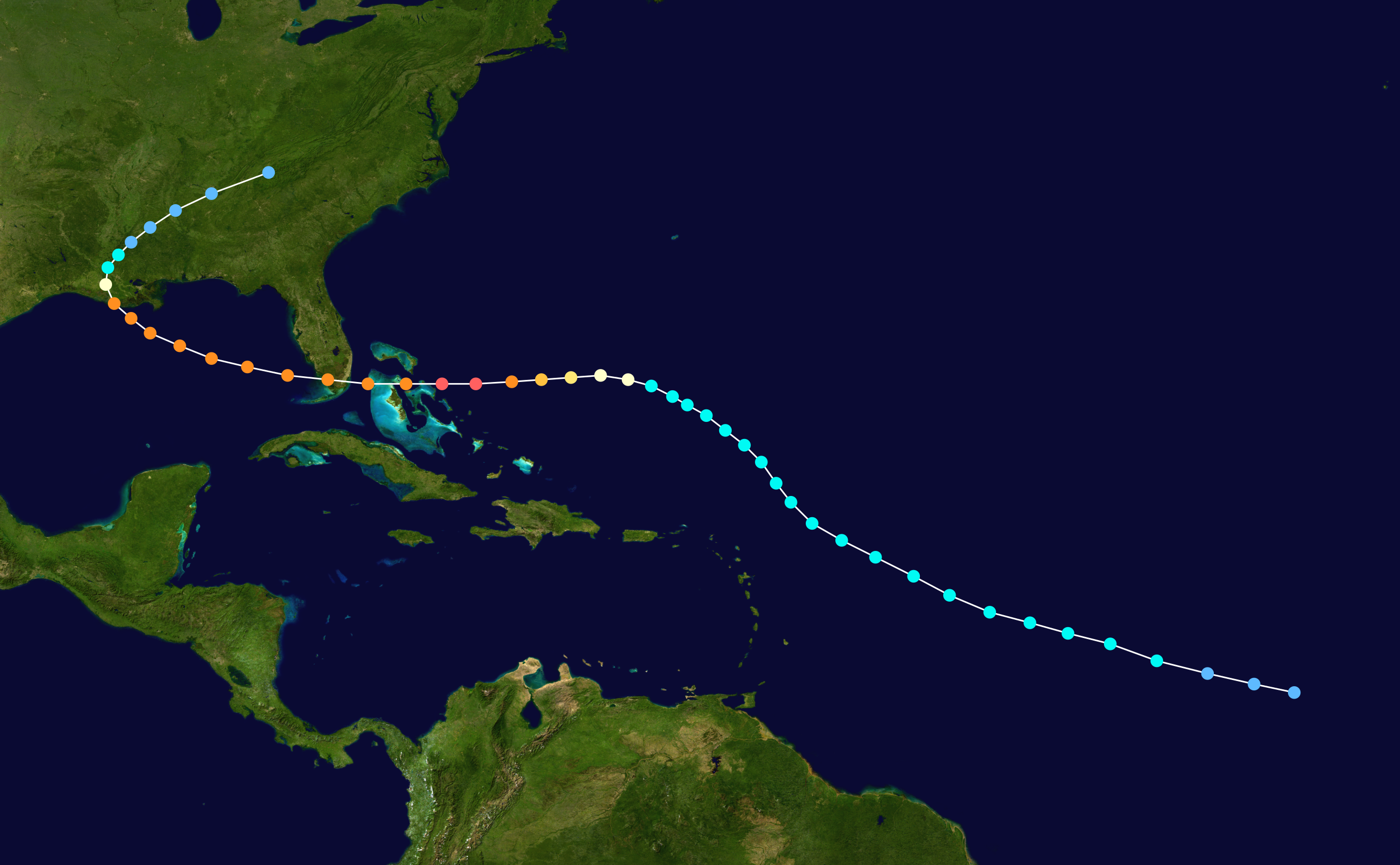
Life would be boring if there were no uncertainties.
My experience has been that often the models do not have these systems initialized very well and that alone can make a big difference. I’ve also noticed that beyond about 3 or 4 days, if you don’t like the forecast, just wait until the next run. It will be much different. Until the predictions begin to stabilize from run to run, I don’t have much confidence. The GFS has already been all over the place with this system, with some runs developing it into a hurricane and others wiping it out. We will have to wait and see if there are enough butterflies in Cuba or the Florida Keys to put some wind back into the chaos machine as the ECMWF suggests.
They are still all over the place….
http://www.sfwmd.gov/sfwmd/common/images/weather/plots/storm_99.gif
The latest 25/18Z GFS run keeps it a broad weak circulation and is now moving it through the Central Gulf of Mexico and into Texas. I’m sure the next run will change again.
http://mag.ncep.noaa.gov/model-guidance-model-area.php
The GFS has already been all over the place…
I would trust the Bams more on two clouds square dancing..they seem to grab disorganized blobs better
This young talented man does one of the best jobs I have seen translating the technical tropics for the layman.
Good analysis, we’ll see what develops…hopefully not too bad.
Where can I follow this guy, thanks a great report!
The storm will probably, like what’s his names cat, follow both paths and, unbeknownst to us, reality will split into two different paths – one for each possibility.
…or not.
If you watch it won’t do that. So get the plane out of the area, turn off the radio and TV, and close your eyes.
A gazillion, one for every alternate gust.
Schrodinger
For this system that is an excellent analogy. It could be trouble for the west coast of Florida or it could not. I will assume it will and if it doesn’t ….whew.
What you can count on…..if it turns deadly it will be man’s fault and if it dissipates to nothing we won’t hear anything.
This is what the global wind map looks like 5 days out, and it is usually on the money. I do not see any circulation.
https://earth.nullschool.net/#2016/08/30/0000Z/wind/isobaric/1000hPa/orthographic=-82.47,33.99,1138
Not yet
Dennnis, you can’t even find it now….
http://www.met.inf.cu/Radar/04Camaguey/cmwMAXw01a.gif
Joe Bastardi called his forecast a bust this morning. Plain old wind shear got it, the same wind shear that has been killing off most large hurricanes for the last decade. We may make that 4,000 days with no major hurricane making land fall on the U.S.
It’s been ripping at 15-20 all week….they had to be blind not to see it
Lots of rain; this has to be pulling a lot of heat out of this hurricane alley. This hurricane season may be yet another dud.
Your kids may never see….a hurricane landfall.
I think into Sept. and Oct.this year, your kids may see one…Cat-3…
Anthony asks;
“…one says we’ll have a signicant tropical storm (Hermine if it reaches that level) the other says it will dissipate. Which one is right? Who knows at this point.”
I believe someone might, because I believe there are ways that such a “hit or miss” situation can be effected by humans . . (with lots of planes that can spray things into such a weather system (and perhaps effect it’s path).
Therefore, given the current situation, both in terms of what to me is an obvious desire for societal disruption on the part of at least some with serious power, and the now waning scientific credibility of the whole HAGW ( ; ) I suspect it will become something that further exacerbates the flooding etc, that already plagues the area.
No, that’s all wrong John. It’s affect not effect.
We have better communication these day of extreme weather events taking place ignoring those named storms crossing the UK which are pure propaganda and help no one. The people in Italy who suffered in the recent earthquake had no warning that it was about to happen and no time to get away.
http://www.cbc.ca/news/canada/nova-scotia/cape-breton-wind-turbine-collapse-inspection-enercon-1.3735802
Gone with the wind…
It won’t be like the other Oscar nominated film in that year, The Wizard of Oz, it isn’t a cyclone Dorothy .
The occasional storm is Climate Hormesis.
Any thoughts about when it gets into the warm waters of the Gulf – past Florida??