NOTE: This writeup is from an acquaintance of mine who wrote some powerful meteorological software, Digital Atmosphere, that I use in my office. He used that software (and others) to analyze the Air France 447 crash from the meteorological perspective. h/t to Mike Moran – Anthony
by Tim Vasquez
Air France flight 447 (AF447), an Airbus A330 widebody jet, was reported missing in the equatorial Atlantic Ocean in the early morning hours of June 1, 2009. The plane was enroute from Rio de Janeiro (SBGL) to Paris (LFPG). Speculation suggested that the plane may have flown into a thunderstorm. The objective of this study was to isolate the aircraft’s location against high-resolution satellite images from GOES-10 to identify any association with thunderstorm activity. Breakup of a plane at higher altitudes in a thunderstorm is not unprecedented; Northwest Flight 705 in 1963 and more recently Pulkovo Aviation Flight 612 in 2006 are clear examples.
Back in the 1990s I did flight route forecasting for the Air Force. One of my assignments in summer 1994 was forecasting was the sector between Mombasa, Kenya and Cairo, Egypt for C-5 and C-141 aircraft. The Sudan region had tropical MCS activity similar to this with little in the way of sensor data, so this incident holds some special interest for me as one of our C-5s could easily have followed a very similar fate. Using what’s available to me I decided to do a little analysis and see if I could determine anything about the fate of AF447 and maybe through some circuitous, indirect means help give authorities some clues on where to look.
1. Reports and evidence
Reports indicate AF447 reported INTOL (S01 21.7′,W32 49.9′ or -1.362,-32.832) at 0133Z and was to proceed to TASIL (N4 00.3′,W29 59.4′, or +4.005,-29.990) in 50 minutes (a true track of 28.1 deg) (source) indicating that it flew high altitude route UN873 (see below).

Enroute High Altitude Caribbean and South America H-4, 30 AUG 2007 (National Geospatial-Intelligence Agency) |
Though the actual flight plan data was not accessible to me, this corresponds well with an actual flight plan found on the Internet for a Varig B767 from Rio de Janeiro to Frankfurt:
|
I decided to project the flight forward from INTOL. An altitude of FL350 and speed of 520 mph was given. Presumably this is ground speed according to the ACARS specification. Compensating for a 10 kt headwind as given by the SBFN sounding this yields an airspeed of M.80, which correlates well with the A330’s typical early cruise profile. This yields the following aircraft coordinates:
|
2. Meteorological analysis
Surface analysis showed the suspected crash region to be within the intertropical convergence zone (ITCZ), which at this time of year is usually found at about the 5-10N parallel. A region of strong trade winds covered most of the tropical North Atlantic and this kept the ITCZ in a somewhat southerly position. The linear convergence along the ITCZ and the unstable atmospheric conditions combined to produce scattered clusters of thunderstorms.

Surface analysis for 0000Z. (NCEP) |
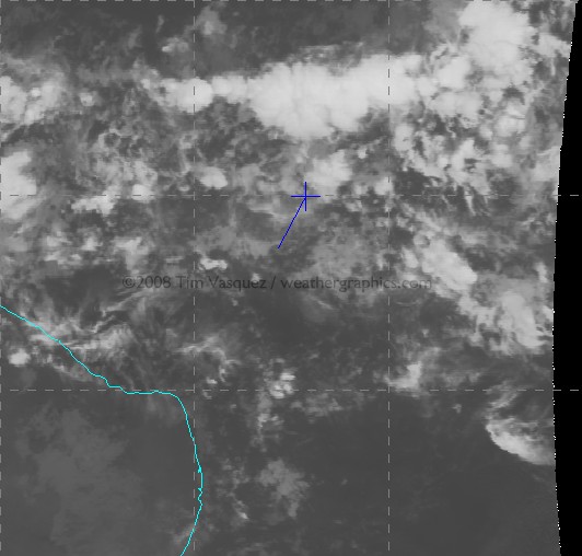
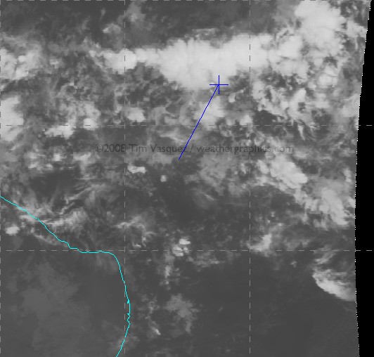
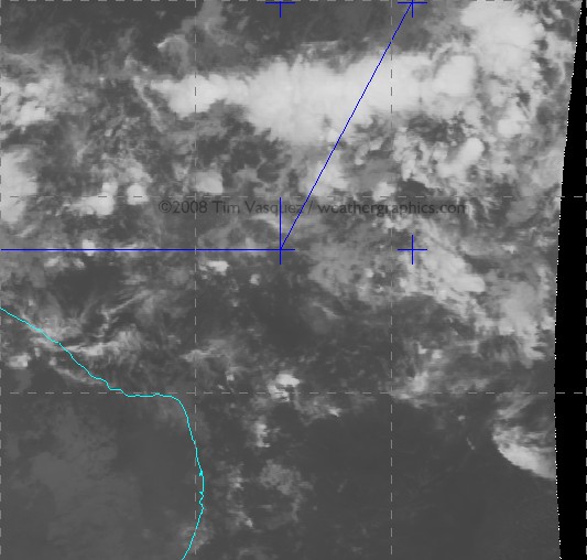
Using McIDAS I acquired satellite GOES-10 satellite data from UCAR and centered it over the region between INTOL and TASIL. I then plotted the waypoints using McIDAS’s built-in coordinate entry panel. Since the source satellite images are georeferenced NOAA/GINI datasets, the points shown here are very accurate and are NOT placed by hand but by lat/long coordinates to the nearest 0.001 deg (0.06 mile). In the image below, the stationary southerly point in blue is INTOL and the aircraft’s estimated location from the above table is marked with a cross. Graticule spacing is 5 degrees. For the orange temperature plots I used the NCL/3aw curve; the sharp gradient of the enhancement from dark to light occurs at 243K (-30 deg C), indicating a cloud top of FL310 assuming the satellite pixel is completely overcast with that layer (which is not always true).
NOTE: If you have trouble seeing some of the large images, the source link is here -Anthony
| Frame Controls | Satellite images |
|---|---|
Loop Mode:
Adjust Speed:
Dwell First/Last:
Frame No: Omit Frame: 1 2 3 4 5 6 7 8 9 |
 |
(Hit reload if you don’t see the satellite images in the looper above)
Raw infrared images are also available here: 0145Z, 0200Z, 0215Z, 0230Z.
And finally this image shows a zoomed image at 0215Z when AF447 made its last transmission:

click for a larger image
About 90% of the cloud material seen on this image is actually multiple levels of convective debris fields from dying storms and activity that occurred previously during the day, with only scattered cirrus fields at flight level. The active thunderstorm areas are defined by small-scale mottled areas of cold cloud tops. Compare with this structural diagram below of a similar tropical MCS in the same area in 1977. It illustrates that planes inflight are clear of most dangerous weather throughout a tropical system except when directly above an active updraft area.

Schematic of a typical tropical MCS observed in the Atlantic southwest of Dakar on 4 Sep 1974. (Structure and Dynamics of a Tropical Squall-Line System, R. A. Houze Jr., Mon. Wea. Rev., 105, 1540-1567) |
It appears AF447 crossed through three key thunderstorm clusters: a small one around 0151Z, a new rapidly growing one at about 0159Z, and finally a large multicell convective system (MCS) around 0205-0216Z. Temperature trends suggested that the entire system was at peak intensity, developing rapidly around 2300-0100Z and finally dissipating around dawn. From a turbulence perspective, these cold spots would be the areas of highest concern as they signal the location of an active updraft producing new cloud material in the upper troposphere.
The last communication from the plane was at 0214Z (12:14 am local meridian time). This was an automated ACARS message reporting an electrical fault and pressurization problem. This would be about the time the plane was beginning to exit the cluster, but not before having flown for 75 miles of numerous updrafts. The exact aircraft location cannot be determined with certainty, however, since a 1-minute time error in position or reporting time translates to 9 miles of spatial error.
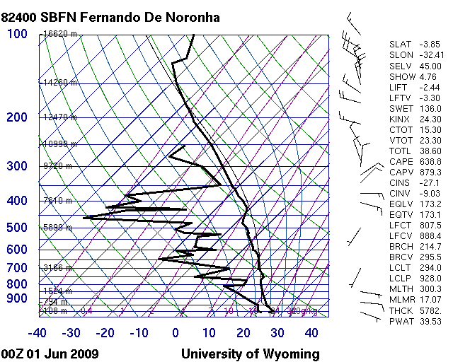
The Fernando de Noronha sounding is available here and shows typical tropical conditions with modest positive energy throughout the column from the surface up to 45,000 ft. There is what looks like anvil level material above 25,000 ft. The significant dry mid-level air is somewhat unusual and suggests the potential for enhanced evaporational cooling in the upper troposphere enhancing downdraft production, and any synoptic-scale lift (if present) enhancing instability through adiabatic cooling of the layer.
I modified this sounding (see below) using the prevailing temperature/dewpoint field across that part of the ocean and modifying for some cooling due to nighttime loss of heating. This is my best guess at the parcel profile that fed this storm. It yields a worst case instability of 1048 J/kg of CAPE, which is moderately strong but considered borderline for typical severe weather. Vertical velocity can be obtained by w=2*CAPE^0.5 yielding a maximum possible updraft speed contribution of 45.8 m/s or 102 mph, though in reality this is usually much less (on the order of half or less) due to precipitation loading and other factors.

3. Conclusions
The satellite imagery indicates that numerous cumulonimbus towers were rising to at least 51,000 ft, and were embedded in extensive stratiform anvils with tops of 35,000 to 45,000 ft. This kind of configuration is actually quite normal for equatorial storms due to the higher tropopause height, but it emphasizes that the aircraft was certainly within the bulk of an extensive cumulonimbus cloud field for a significant amount of time and that storms could indeed have been a contributing factor to the crash.
I’ve edited this section Monday night to cut down on the speculation about the accident chain, especially since I don’t know a whole lot about A330 systems. The airliners.net board and other sites cover the aircraft and CRM systems quite well. What I will try to do, however, is summarize what the aircraft probably encountered based on the data and my own experience.
* Turbulence — Turbulence is a definite candidate as a contributing factor. There is an isolated storm at (1.6,-31.5) that appears suddenly at 0200Z just as the A330 enters the main MCS cluster. From a turbulence perspective it is by far the most dangerous formation found on the loop. However it is 10-25 km to the left of UN873 and it is doubtful the crew would have been deviating at this time. Other cells like this one embedded within the main MCS may have caused severe turbulence. Young updrafts are particularly dangerous to flights because they contain significant rising motion yet precipitation fields have not yet fully developed and airborne radar signatures are weak, reducing the likelihood the crew will deviate around the cell. Another concern is the extensive upper-level dry air shown on the SBFN sounding (not counting the anvil debris at 350-300 mb), which may have contributed to enhanced evaporative cooling in and around the anvil and aggravated the turbulence experienced by the flight, especially around the margins of anvil clouds and towers. It is worth considering that cumulative periods of heavy turbulence crossing through the cluster may have caused minor internal damage that progressed in some way into an emergency.
* Icing — With a flight level temperature of -43 deg C suggested by the proximity sounding the A330 would have been flying mostly in rime ice and possibly some clear ice and graupel. At -43 deg C, water cannot exist even in supercooled form (see here for an explanation). The equivalent potential temperature throughout the profile is absolutely insufficient to bring warmer air with supercooled water to flight level. Without the supercooled water there is very little ice buildup on the airframe. My conclusion is that unless the plane descended below FL300 icing would not be the culprit.
* Lightning — Due to the high cloud tops and freezing level at 16,000 ft, there was extensive precipitation by cold rain process and it is likely the MCS was electrified. Lightning of course being considered with good reason since the A330 is one of the most computerized and automated airliners in service. I will say based on my 25 years of meteorology the storms were almost definitely producing lightning. As far what a strike would do to the A330, I have to leave that to to the avionics experts. Some answers might be found at http://www.airliners.net/aviation-forums/.
* Precipitation — A dual engine flameout due to precipitation or ice ingestion is a noteworthy possibility as has been discussed on other sites (specific to the A330 type too). The precipitable water content in any tropical weather system can run very high. However a rain-induced flameout is not possible because supercooled water cannot exist at the -43C cruise altitude and insufficient equivalent potential temperature exists, even in updraft cores, to bring warmer air beyond a few degrees change to the flight level. Therefore the plane at FL350 was completely within some mixture of rime ice, graupel, or small hail. But again, as the link indicates, even ice poses risks to the engine.
* Hail — I got a few comments about hail. I am not entirely convinced that structural hail damage is a factor, partly because I can’t recall hearing much about large damaging hail at altitude in my experience with equatorial flight operations. This would require strong instability, which I’m not yet sure we have, not only to grow the stones but to loft large hailstones from the embryo “nursery” at FL200-250 up to flight level. A value of 1000 J/kg CAPE is really on the fence but not out of the question. The other problem is the mounting body of evidence (see SPC studies) suggesting well-sheared storms (this profile is poorly sheared) are the ones conducive to structures that support hail growth. Finally, another issue is airborne radars are be highly sensitive to hail because of the very high backscatter values of ice, making evasive action likely, and the “young updrafts” I pointed out earlier as a threat would not have provided the residence times necessary yet to contain hailstones; their main threat would be severe turbulence. I am not sure about the hail hypothesis, but I believe there is a high probability of graupel, small ice pellets, or small hail at FL350 in the storm complex (see Icing above).
Overall what we know for sure is weather was a factor and the flight definitely crossed through a thunderstorm complex. There is a definite correlation of weather with the crash. However the analysis indicates that the weather is not anything particularly exceptional in terms of instability or storm structure. It’s my opinion that tropical storm complexes identical to this one have probably been crossed hundreds of times over the years by other flights without serious incident.
Still, in the main MCS alone, the A330 would have been flying through significant turbulence and thunderstorm activity for about 75 miles (125 km), lasting about 12 minutes of flight time. Of course anything so far is speculation until more evidence comes in, and for all we know the cause of the downing could have been anything from turbulence to coincidental problems like a cargo fire.
My own opinion of the crash cause, as of Monday night, based on the complete lack of a HF radio call and consideration of all of the above, suggests severe turbulence (see the BOAC 911 and BNF 250 tragedies) combining in some unlikely way with CRM/design/maintenance/procedural/other deficiencies to trigger a failure cascade. We can almost certainly count on some unexpected surprises once the CVR is recovered. Until then, all we can do is await the investigation and hope that the world’s flight operations stay safe until AFR447’s lessons are revealed.
Supporting news: Air France Pilot’s Last Communication on Bad Weather
Look at the seismic activity in area prior to the crash … there was a seismic event on the mid Atlantic Ridge in the early hours of 31 May at position N5° W32° … a bit of a coincidence I guess … more so in that there doesn’t seem to be a lot of seismic activity in this area relative to other faults zones. Could there have been some sort of emission?
See: http://www.iris.edu/seismon/
REPLY: There is not any known connection between seismic activity and thunderstorm activity, except that of thunderstorms forming on active volcanic eruptions. Unless there is a new volcano emerging from the sea, the scenario is doubtful. – Anthony
no one dares mention the possibility that a SHHH! (bomb) may have been involved. Wait, who said that? Did I say that? I didn’t say that!
In spite of the fact that a bomb threat was called in from Buenos Aires just a few days ago, on May 27. Pay no attention to the man behind the curtain saying nasty things like that.
http://www.sfgate.com/cgi-bin/article.cgi?f=/n/a/2009/06/03/international/i081726D51.DTL
But don’t worry, that can’t be it. FTA: “A Pentagon official also said there was no indication of terrorism.”
Other than the fact that a technologically advanced plane catastrophically broke up in midflight and plunged into the ocean for no apparent reason, that is.
As someone who flies extremely often, it is always disturbing to see planes go down, and especially to think that they could break apart at altitude.
I, for one, feel for the families and friends of those lost, and hope they get the closure they so desperately need.
Thanks for this fascinating analysis, I certainly hope that eventually we can get a definitive answer to what happened to this flight. Maybe the black boxes will be recovered and contain enough information to clear up the mystery.
Further to ice causing flameouts see:
High Altitude Engine Flame-Outs By Patrick R. Veillette, Ph.D. , Business & Commercial Aviation, July 23, 2007
To me, it seems appalling that the plane was not redirected to avoid this storm system. Surely the control towers had an idea what was going on weather-wise in the vicinity of the crash site. I understand that time is money when it comes to the airlines, but the cost here was obviously greater than anyone anticipated. Please, correct me if I am wrong.
REPLY: There’s no ground based remote reporting weather radar out there, all they have is satellite and synoptic maps. It is the pilot’s responsibility to detect and avoid storms using the plane’s onboard weather radar.- Anthony
AF 447 was very near to a TAP plane at the time it went down. Pilot from TAP, which was slightly to the west, confirmed on Portuguese TV that it was a “normal trip for that zone, smooth”. In the meantime, brazillians have suggested a link with global warming. There is even a greenie that said he had predicted it more than 2 years ago!
Ecotretas
One heck of a coincidence though!
The disturbing thing to me is that the A330 design is derived from the A300.
Both have composite tails.
In the AA-587 crash in Nov of 2001, the NTSB blamed the failure of the A300’s composite tail on the co-pilot.
The NTSB claimed that the pilot made dramatic rudder inputs to counter wake turbulence from a 747 which had departed Kennedy two minutes earlier.
See ground tracks I developed for both planes:
http://usread.com/flight587/AA587-FLIGHT_PAV2-trk4b.jpg
See Victor Trombetta’s analysis of AA 587’s demise here: http://www.usread.com/flight587/Timeline.html
The NTSB said that the pilot, to combat mild turbulence, over controlled the aircraft by swinging the rudder fully to one side and then all the way to the other side, and it was this over-control which exceeded the tail’s design limits.
Pictures of the tail damage are here:
http://www.ntsb.gov/events/2001/AA587/tailcomp.htm
Now if this is possible from rudder inputs in mild turbulence in clear air at relatively low airspeed over NY, consider what could happen at high speed in major turbulence over the ITCZ.
Arthur
Massive underwater eruptions do occur at depth and are known to release considerable amounts of gas … see: http://www.whoi.edu/page.do?pid=7545&tid=282&cid=44586&ct=162
A pilot flying 150 miles behind saw two very bright flashes. The complete and sudden breakup at altitude (leaving a debris field 30+ miles long on the ocean surface) is not consistent with engine failure, or electrical failure, or lightning strike. Weather notwithstanding, an onboard explosion seems most likely to me.
In some ways, to think it was a terror attack is more comforting; I’d greatly prefer that explanation to suggesting that the aircraft was flawed, or that thunderstorms can bring down aircraft at altitude.
I have just read on the net that it may have been a bomb, as the French authorities had received a threat. How much truth there is to this, I do not know.
This is truly a remarkable story. A specialist appears from nowhere and gives us a very solid , reasonably technical (but skip to the conclusion, if you like), and accessible presentation on the weather and its likely impact on a disaster only two days old.
Amazing.
If you understand why this is truly an impressive feat, then you understand why the New York Times business model is doomed.
Actually, the possibility has been widely mentioned, but authorities don’t have any reason to jump to that conclusion. We have a very likely candidate for the cause that’s irrefutable. They also have the stream of data from the plane itself describing how it was failing, presumably they’ve not found anything in this to make them suspect a bomb.
The Atlantic has developed its own mini-El Nino-state right now so convective activity is expected to be strong in the equatorial region.
http://www.osdpd.noaa.gov/PSB/EPS/SST/data/anomnight.6.1.2009.gif
http://www.cpc.ncep.noaa.gov/products/people/wwang/rtgsst/rtgsst.gif
I flew the following day on AF306, Paris to Seattle. Same model A/C (A330) I’d say the crew and passengers were a bit nervous….but I suspected lightning or turbulence as soon as I heard the story.
But I’m with CodeTech…. it’s just disturbing. If I’m going to die in a plane, I’d prefer controlled flight into terrain in a cloud…. Not enamored with the cataclismic break up and plunge to sea from altitude scenario.
This blog is PURE SPECULATION today. You CANNOT know what happened on that flight, and you state ‘Overall what we know for sure is weather was a factor and the flight definitely crossed through a thunderstorm complex. There is a definite correlation of weather with the crash.’
Do you have the black box?
I think not. IF they find the black box and then If your theory is correct, hats off to you. But If they find the black box and they find weather wasn’t a factor, the only weather we’ll be seeing is the wind blowing the egg off your face.
You list so many factors related to weather but miss out ball lightning. The plane is a Faraday cage, and lightning wouldn’t be a factor, unless I misunderstand physics.
I would think if it were just a matter of a flameout, there would have been some kind of radio transmission made because the pilots would have had more time to send a message and they would have wanted to relay their coordinates. This would suggest a violent turbulence event that led to the plane going out of control and/or breaking apart mid-air after which there would be very limited time for the pilots to do anything. Or, of course there is the unfortunate possibility of foul play.
I didn’t expect the meteorological inquisition!
The lack of a Mayday or any other radio transmission indicating a problem to me means an immediate catastrophic failure. Either sudden electrical failure which would prevent the radio from working, or something which prevented the pilots from physically making the call.
A bomb isn’t out of the question, but right now it’s sheer speculation.
Just look at all these strange sounding terms – INTOL … TASIL. At least I was able to find that the distance between the two points was 663 km. For example, “INTOL is an RNAV waypoint located in the Atlantic Ocean, 565 km from Natal, Brazil. The TASIL waypoint is located 1228 kilometers from Natal. TASIL is at the border of the Recife FIR and Dakar Oceanic FIR.” Further details can be found atProjectDisaster. So the bottom line is that all we have so far is speculative but educated guess work; hope they find the black boxes.
jon: The estimated location at the last transmission at 0215Z was “+3.290,-30.357”. The quake 00:47:04 UTC at “4.971°N, 32.615°W”
http://earthquake.usgs.gov/eqcenter/recenteqsww/Quakes/us2009hhab.php
It was speculated years ago that methane releases could down an airliner, but this has never been observed to happen. Even if the quake released a whole lot of methane (which has been created in a lab in deep crust/mantle conditions), the methane would have had to travel several miles during the 1.5 hours and not been ignited nor dispersed by the thunderstorms. The methane would have to be of large enough volume to mechanically affect the plane (plane would fall in methane, but had 35,000 feet in which to recover), or to affect the airframe. The engines probably did not fail, or the crew would have reported the problem. The plane’s problem was not that the crew was asphyxiated by methane, because the plane would have probably have continued flying.
I’m ignoring the depth of the seismic event because it’s shallow and I suspect the surface is within the margin of error of the estimate.
A seismic event can also happen due to volcanic eruption (no other planes had ash damage), landslide (irrelevant), explosion (not reported by other planes, and nuclear surface or airburst would be needed to affect planes at 35,000 feet), or impact event (no meteor fireballs reported by other planes – at 35,000 feet it probably wouldn’t be flaming but something large enough to cause a 4.0 quake should have been visible over the Atlantic when it first hit atmosphere).
Rickj (10:22:10) :
I prefer to look at it as a good analysis based on very limited data.
Rickj (10:22:10) :
This blog is PURE SPECULATION today.
Yup. And?
You list so many factors related to weather but miss out ball lightning. The plane is a Faraday cage, and lightning wouldn’t be a factor, unless I misunderstand physics.
Ball lightning has been reported rolling down the aisle of an airliner. Strange stuff. Airliners aren’t complete Faraday cages, as witnessed by all the people talking on their cell phones during taxi-in.
Airliners can build up tremendous static charges flying through high clouds. I’ve often seen St Elmo’s fire glowing purple off the windshield wipers, and static discharge trees snapping across the windscreen. That might be a concern, as computerized as the Airbus is, and the initial report that automatic maintenance data downlinks concerned sequential electrical system failures.
Meanwhile, a truly excellent effort looking at the weather circumstances surrounding the flight.
Anthony, must we be presented with Church of Scientology ads (dianetics.org)? I don’t mind commercial ads for products but … well … there it is.
I think there has been a lot of jumping to conclusions by various news organizations. Generally lightning, for example, won’t bring down a plane but when there are all kinds of stray currents flying around, there could be an electrical arc somewhere that one does want to see one … like in an empty fuel tank or something … if there is a shielding fault.
The final transmission reporting electrical and pressure problems would be consistent with a catastrophic failure. The amount of turbulence being experienced probably means all of the crew would have been awake or at least not in a deep sleep.
Rapid decompression at that altitude from something like the loss of a cockpit window would be extremely difficult or possibly impossible to manage but probably wouldn’t generate a simultaneous loss of electric power.
Loss of both engines would result in problems with electrical power and pressurization but should be manageable.
I have a couple of questions … on that new cell that they would have hot first, is the position shown in the charts the position the cell was in when the last transmission was received or is that the position of the cell when the flight passed near it? What was the speed and direction of that cell? Could it be that the plane flew directly through it and the position of the cell is moved a bit by the time the flight’s final transmission?
My bet would be on one of two things:
1. Cascading structural failure possibly beginning long ago.
2. Fuel air explosion along the lines of TWA 800 possibly due to anomalous currents induced by lightning strike.
REPLY: I’ll see if I can get rid of dianetics – Anthony