NOTE: This writeup is from an acquaintance of mine who wrote some powerful meteorological software, Digital Atmosphere, that I use in my office. He used that software (and others) to analyze the Air France 447 crash from the meteorological perspective. h/t to Mike Moran – Anthony
by Tim Vasquez
Air France flight 447 (AF447), an Airbus A330 widebody jet, was reported missing in the equatorial Atlantic Ocean in the early morning hours of June 1, 2009. The plane was enroute from Rio de Janeiro (SBGL) to Paris (LFPG). Speculation suggested that the plane may have flown into a thunderstorm. The objective of this study was to isolate the aircraft’s location against high-resolution satellite images from GOES-10 to identify any association with thunderstorm activity. Breakup of a plane at higher altitudes in a thunderstorm is not unprecedented; Northwest Flight 705 in 1963 and more recently Pulkovo Aviation Flight 612 in 2006 are clear examples.
Back in the 1990s I did flight route forecasting for the Air Force. One of my assignments in summer 1994 was forecasting was the sector between Mombasa, Kenya and Cairo, Egypt for C-5 and C-141 aircraft. The Sudan region had tropical MCS activity similar to this with little in the way of sensor data, so this incident holds some special interest for me as one of our C-5s could easily have followed a very similar fate. Using what’s available to me I decided to do a little analysis and see if I could determine anything about the fate of AF447 and maybe through some circuitous, indirect means help give authorities some clues on where to look.
1. Reports and evidence
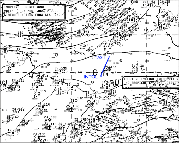
Reports indicate AF447 reported INTOL (S01 21.7′,W32 49.9′ or -1.362,-32.832) at 0133Z and was to proceed to TASIL (N4 00.3′,W29 59.4′, or +4.005,-29.990) in 50 minutes (a true track of 28.1 deg) (source) indicating that it flew high altitude route UN873 (see below).

Enroute High Altitude Caribbean and South America H-4, 30 AUG 2007 (National Geospatial-Intelligence Agency) |
Though the actual flight plan data was not accessible to me, this corresponds well with an actual flight plan found on the Internet for a Varig B767 from Rio de Janeiro to Frankfurt:
|
I decided to project the flight forward from INTOL. An altitude of FL350 and speed of 520 mph was given. Presumably this is ground speed according to the ACARS specification. Compensating for a 10 kt headwind as given by the SBFN sounding this yields an airspeed of M.80, which correlates well with the A330’s typical early cruise profile. This yields the following aircraft coordinates:
|
2. Meteorological analysis
Surface analysis showed the suspected crash region to be within the intertropical convergence zone (ITCZ), which at this time of year is usually found at about the 5-10N parallel. A region of strong trade winds covered most of the tropical North Atlantic and this kept the ITCZ in a somewhat southerly position. The linear convergence along the ITCZ and the unstable atmospheric conditions combined to produce scattered clusters of thunderstorms.
Surface analysis for 0000Z. (NCEP) |
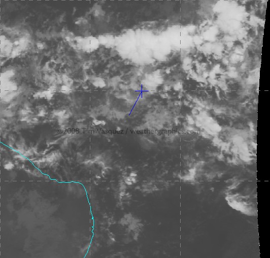
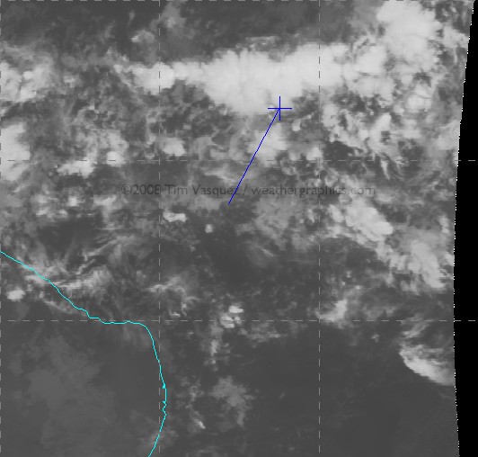
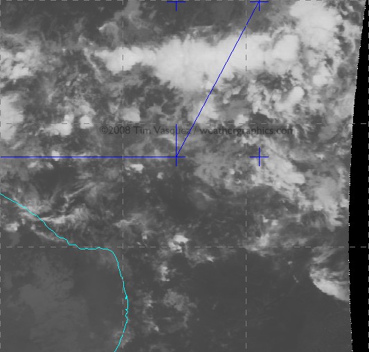
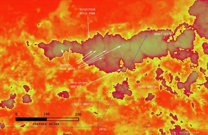
Using McIDAS I acquired satellite GOES-10 satellite data from UCAR and centered it over the region between INTOL and TASIL. I then plotted the waypoints using McIDAS’s built-in coordinate entry panel. Since the source satellite images are georeferenced NOAA/GINI datasets, the points shown here are very accurate and are NOT placed by hand but by lat/long coordinates to the nearest 0.001 deg (0.06 mile). In the image below, the stationary southerly point in blue is INTOL and the aircraft’s estimated location from the above table is marked with a cross. Graticule spacing is 5 degrees. For the orange temperature plots I used the NCL/3aw curve; the sharp gradient of the enhancement from dark to light occurs at 243K (-30 deg C), indicating a cloud top of FL310 assuming the satellite pixel is completely overcast with that layer (which is not always true).
NOTE: If you have trouble seeing some of the large images, the source link is here -Anthony
| Frame Controls | Satellite images |
|---|---|
Loop Mode:
Adjust Speed:
Dwell First/Last:
Frame No: Omit Frame: 1 2 3 4 5 6 7 8 9 |
 |
(Hit reload if you don’t see the satellite images in the looper above)
Raw infrared images are also available here: 0145Z, 0200Z, 0215Z, 0230Z.
And finally this image shows a zoomed image at 0215Z when AF447 made its last transmission:
click for a larger image
About 90% of the cloud material seen on this image is actually multiple levels of convective debris fields from dying storms and activity that occurred previously during the day, with only scattered cirrus fields at flight level. The active thunderstorm areas are defined by small-scale mottled areas of cold cloud tops. Compare with this structural diagram below of a similar tropical MCS in the same area in 1977. It illustrates that planes inflight are clear of most dangerous weather throughout a tropical system except when directly above an active updraft area.

Schematic of a typical tropical MCS observed in the Atlantic southwest of Dakar on 4 Sep 1974. (Structure and Dynamics of a Tropical Squall-Line System, R. A. Houze Jr., Mon. Wea. Rev., 105, 1540-1567) |
It appears AF447 crossed through three key thunderstorm clusters: a small one around 0151Z, a new rapidly growing one at about 0159Z, and finally a large multicell convective system (MCS) around 0205-0216Z. Temperature trends suggested that the entire system was at peak intensity, developing rapidly around 2300-0100Z and finally dissipating around dawn. From a turbulence perspective, these cold spots would be the areas of highest concern as they signal the location of an active updraft producing new cloud material in the upper troposphere.
The last communication from the plane was at 0214Z (12:14 am local meridian time). This was an automated ACARS message reporting an electrical fault and pressurization problem. This would be about the time the plane was beginning to exit the cluster, but not before having flown for 75 miles of numerous updrafts. The exact aircraft location cannot be determined with certainty, however, since a 1-minute time error in position or reporting time translates to 9 miles of spatial error.
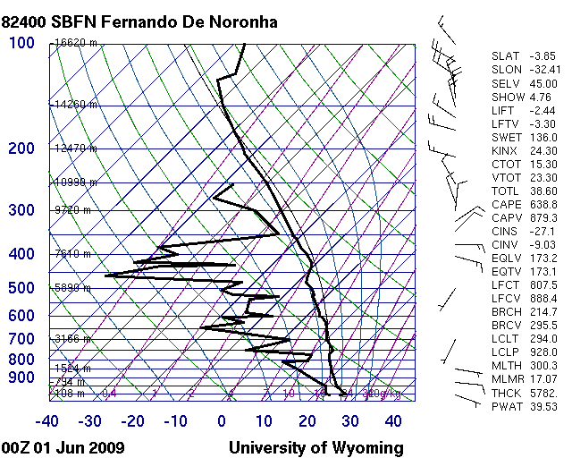
The Fernando de Noronha sounding is available here and shows typical tropical conditions with modest positive energy throughout the column from the surface up to 45,000 ft. There is what looks like anvil level material above 25,000 ft. The significant dry mid-level air is somewhat unusual and suggests the potential for enhanced evaporational cooling in the upper troposphere enhancing downdraft production, and any synoptic-scale lift (if present) enhancing instability through adiabatic cooling of the layer.
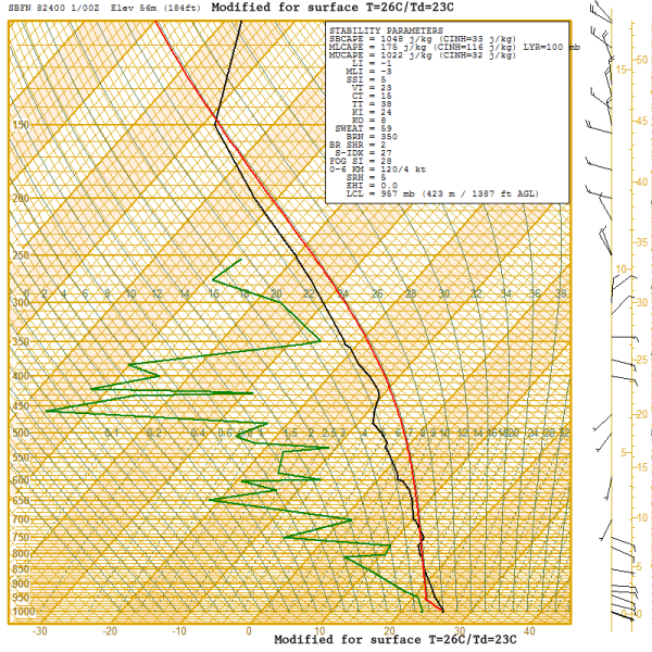
I modified this sounding (see below) using the prevailing temperature/dewpoint field across that part of the ocean and modifying for some cooling due to nighttime loss of heating. This is my best guess at the parcel profile that fed this storm. It yields a worst case instability of 1048 J/kg of CAPE, which is moderately strong but considered borderline for typical severe weather. Vertical velocity can be obtained by w=2*CAPE^0.5 yielding a maximum possible updraft speed contribution of 45.8 m/s or 102 mph, though in reality this is usually much less (on the order of half or less) due to precipitation loading and other factors.
3. Conclusions
The satellite imagery indicates that numerous cumulonimbus towers were rising to at least 51,000 ft, and were embedded in extensive stratiform anvils with tops of 35,000 to 45,000 ft. This kind of configuration is actually quite normal for equatorial storms due to the higher tropopause height, but it emphasizes that the aircraft was certainly within the bulk of an extensive cumulonimbus cloud field for a significant amount of time and that storms could indeed have been a contributing factor to the crash.
I’ve edited this section Monday night to cut down on the speculation about the accident chain, especially since I don’t know a whole lot about A330 systems. The airliners.net board and other sites cover the aircraft and CRM systems quite well. What I will try to do, however, is summarize what the aircraft probably encountered based on the data and my own experience.
* Turbulence — Turbulence is a definite candidate as a contributing factor. There is an isolated storm at (1.6,-31.5) that appears suddenly at 0200Z just as the A330 enters the main MCS cluster. From a turbulence perspective it is by far the most dangerous formation found on the loop. However it is 10-25 km to the left of UN873 and it is doubtful the crew would have been deviating at this time. Other cells like this one embedded within the main MCS may have caused severe turbulence. Young updrafts are particularly dangerous to flights because they contain significant rising motion yet precipitation fields have not yet fully developed and airborne radar signatures are weak, reducing the likelihood the crew will deviate around the cell. Another concern is the extensive upper-level dry air shown on the SBFN sounding (not counting the anvil debris at 350-300 mb), which may have contributed to enhanced evaporative cooling in and around the anvil and aggravated the turbulence experienced by the flight, especially around the margins of anvil clouds and towers. It is worth considering that cumulative periods of heavy turbulence crossing through the cluster may have caused minor internal damage that progressed in some way into an emergency.
* Icing — With a flight level temperature of -43 deg C suggested by the proximity sounding the A330 would have been flying mostly in rime ice and possibly some clear ice and graupel. At -43 deg C, water cannot exist even in supercooled form (see here for an explanation). The equivalent potential temperature throughout the profile is absolutely insufficient to bring warmer air with supercooled water to flight level. Without the supercooled water there is very little ice buildup on the airframe. My conclusion is that unless the plane descended below FL300 icing would not be the culprit.
* Lightning — Due to the high cloud tops and freezing level at 16,000 ft, there was extensive precipitation by cold rain process and it is likely the MCS was electrified. Lightning of course being considered with good reason since the A330 is one of the most computerized and automated airliners in service. I will say based on my 25 years of meteorology the storms were almost definitely producing lightning. As far what a strike would do to the A330, I have to leave that to to the avionics experts. Some answers might be found at http://www.airliners.net/aviation-forums/.
* Precipitation — A dual engine flameout due to precipitation or ice ingestion is a noteworthy possibility as has been discussed on other sites (specific to the A330 type too). The precipitable water content in any tropical weather system can run very high. However a rain-induced flameout is not possible because supercooled water cannot exist at the -43C cruise altitude and insufficient equivalent potential temperature exists, even in updraft cores, to bring warmer air beyond a few degrees change to the flight level. Therefore the plane at FL350 was completely within some mixture of rime ice, graupel, or small hail. But again, as the link indicates, even ice poses risks to the engine.
* Hail — I got a few comments about hail. I am not entirely convinced that structural hail damage is a factor, partly because I can’t recall hearing much about large damaging hail at altitude in my experience with equatorial flight operations. This would require strong instability, which I’m not yet sure we have, not only to grow the stones but to loft large hailstones from the embryo “nursery” at FL200-250 up to flight level. A value of 1000 J/kg CAPE is really on the fence but not out of the question. The other problem is the mounting body of evidence (see SPC studies) suggesting well-sheared storms (this profile is poorly sheared) are the ones conducive to structures that support hail growth. Finally, another issue is airborne radars are be highly sensitive to hail because of the very high backscatter values of ice, making evasive action likely, and the “young updrafts” I pointed out earlier as a threat would not have provided the residence times necessary yet to contain hailstones; their main threat would be severe turbulence. I am not sure about the hail hypothesis, but I believe there is a high probability of graupel, small ice pellets, or small hail at FL350 in the storm complex (see Icing above).
Overall what we know for sure is weather was a factor and the flight definitely crossed through a thunderstorm complex. There is a definite correlation of weather with the crash. However the analysis indicates that the weather is not anything particularly exceptional in terms of instability or storm structure. It’s my opinion that tropical storm complexes identical to this one have probably been crossed hundreds of times over the years by other flights without serious incident.
Still, in the main MCS alone, the A330 would have been flying through significant turbulence and thunderstorm activity for about 75 miles (125 km), lasting about 12 minutes of flight time. Of course anything so far is speculation until more evidence comes in, and for all we know the cause of the downing could have been anything from turbulence to coincidental problems like a cargo fire.
My own opinion of the crash cause, as of Monday night, based on the complete lack of a HF radio call and consideration of all of the above, suggests severe turbulence (see the BOAC 911 and BNF 250 tragedies) combining in some unlikely way with CRM/design/maintenance/procedural/other deficiencies to trigger a failure cascade. We can almost certainly count on some unexpected surprises once the CVR is recovered. Until then, all we can do is await the investigation and hope that the world’s flight operations stay safe until AFR447’s lessons are revealed.
Well … if this were true, they wouldn’t spend so much engineering time and money figuring out how to shield sensitive electronics from the effects of lightning strikes.
From 1963 …
That one turned out to be due to the strike igniting gasoline fumes inside a fuel cell. Presumably they do a better job of isolating tanks, etc, than they did in this earlier airliner.
Damage from lightning strikes is normally minor but not infrequent. The cabin interior is insulated from the skin and other metal components, passengers don’t get fried …
I’ve been in an airliner struck by lightning while descending into PDX. It was … interesting. Big explosion sounds. Bright light from the strike and an orange flaming phenomena outside – dirt on the skin vaporizing? Silence from the cockpit for what seemed like several minutes, presumably as they went through a post-strike checklist to make sure everything was ticking normally. Engines working, everything fine, I wasn’t worried. The woman next to me had never flown before and had been worried from the time we taxied from the gate – did she ever fly again? I’ve wondered. Finally one of the pilots got on the intercom and assured everyone that things were OK, but he couldn’t keep his voice steady. Loud explosion-type noises have their affect even on the professionals, I guess.
Thanks for the weather analysis.
Now let’s wait for the official accident analysis.
I am sure the officials will go to their limits to find the cause of the accident.
This will be a most difficult salvation effort due to the location and the equipment needed because the ocean at this location is very deep and covered with undersea mountains.
Yes, it’s speculation, but given the preliminary evidence available (the weather zone), it seems that it is reasonable.
Not only could lightning and extreme turbulence be a factor, but given the nature of the Tropical Convergence Zone, “extreme lighning” such as “Elves”, Red Sprites”, “Blue Jets” and “Positive Lightning” need to be considered.
Never heard of these types of lightning?
Well, that’s okay because only in the last 15 years or so have they been confirmed by Science.
Pilots of commercial airliners had known of these phenomena for years, but were mostly leary of reporting them for fear that they wouldn’t be taken seriously and it might even impact their careers. (Where have we seen that before?) But early in the 1990s investigators began to take the rumors seriously and to look for evidence of lightning above the clouds.
Scientists did, indeed, find these rumored “extreme” lightning phenomenon by reviewing old satellite photos.
The causes for the “extreme lightning” are not well understood, but there are ideas that this lightning is an example of Earth’s weather being connected to larger electrical phenomena ultimately associated with the electromagnetic energy emitted by the Sun and recieved, here, on Earth.
I Love Smokey:
Speculation:
I am an A340 First Officer and my airline suffered a serious incident a couple years ago in similar circumstances when encountering severe icing and turbulence at high altitude which led to the sudden loss of all ADIRUs (Air Data/Inertial Reference Units) and to a reconfiguration to alternate fly by wire control law as a result, forcing the crew to declare an inflight emergency and land to the nearest suitable airport. Then it is not difficult for me to make a parrallel with flight AF447’s last ACARS transmissions:
– 0210: Auto Pilot disconnects
– 0211,12,13: series of ADIRU and ISIS messages
– 0213: SEC1 FAULT, PRIM1 FAULT (Alternate Law) with lots of ATA34 (Navigation Systems), ATA22 (Auto Flight), and ATA27 (Flight Controls) messages, and increase of cabin vertical speed. Best regards,
Alex…..?
http://www.weathergraphics.com/tim/af447/
The concept of a Faraday cage being a a”magical” protection against lighting is flawed in my view. The aircraft frame will probably protect occupants from being killed, but protection of electronic circuitry is far more difficult.
My experience is in the missile industry, which does not have the more rigourous requirements of the air-industry, so I may be mistaken here. Nevertheless lightning is not trivial.
This is a new aircraft design. Maybe a flaw in the electrical bonding has been shown up. Who knows?
As a career aviator (albeit military) I read this post with interest, and appreciate the author’s time putting it up.
One of things I’ve noticed about conjectural discussions about aviation mishaps: It doesn’t matter how well informed the writing, or how persuasive the argument, there is always at least one commenter that shows up and says “Let’s wait for the official analysis.”
Which makes me wonder, why? This is simply an extended water cooler discussion like you might have at any work place, bar or cafe. In this case we happen to be lucky enough to “work” in the same space as a person with expert knowledge on a plausible causal factor. Not that he’s there, not that he has access to the wreckage – and that’s the whole point, if he was, he’d be obligated to hold fire until the final conclusions had been drawn. But this does provide something to noodle over while waiting the interminable period between finding the DFDR and CVR – if we ever do – and reading the analysis that follows.
Why do people take it upon themselves to be the town scold on issues like this?
Task of Locating Air France Black Boxes Begins
to dhogaza:
“We have a very likely candidate for the cause that’s irrefutable.”
There’s not one shred of hard evidence that it happened that way at all. Just post event arm-chair spin doctoring.
There, I refuted it.
and to AnonyMoose:
“I didn’t expect the meteorological inquisition!”
NO ONE EXPECTS THE METEROLOGICAL INQUISITION!!!
Faraday cage? click
@ur momisugly lex:
Yes, there are always those that want only the “official” version, and don’t want others to offer opinions, whether educated or not.
These people tend to defend “authority” no matter what the situation.
Now, there is nothing wrong with “authority” or wanting the “official” version, most times that turns out to be the most informed and expertise.
But scolding people for offering an opinion and suggesting they “should just pipe down” is unrealistic given human nature.
And frankly, as we have seen on this website, “authority” is not always right and nor the “official” version a full accounting of the evidence.
Hopefully, in due course, a full and fair accounting will be made by the relevant authorities and the skys will be safer for the general traveling public.
A few notes on decoding the Varig Rio (SBGL) to Frankfurt (EDDF) flight plan –
The first items are about the aircraft and the nav equipment it has. The -N0485F290 means the flight will climb to 29000 ft altitude and fly at 285 knots true air speed. The UA…, UB…, and UN… are Upper airways, standard routes. Five letter names are waypoints. INTOL/M080F320 means that at INTOL the flight will climb to Flight Level 320 (32000 ft) and fly at Mach .80 . GMMM0746 LPPC0836 … are UTC Greenwich times that the flight will cross into the GMMM and LPPC air traffic control sectors. ETOPS is for “extended twin engine operations” and says the aircraft must remain within 120 minutes of a landing field (with one engine out). ALTS are two alternate airports, SBNT and GVAC.
Speeds are airspeeds, not ground speed. Air traffic computers have the current winds and compute the ground speeds.
.
dhogaza (12:23:24) :
“Witnesses said they saw lightning hit the plane, transforming it into a ball of fire. They told of seeing some occupants spilled from the flaming wreckage as it plummeted into a cornfield. The plane, a Boeing 707 . . . ”
That one turned out to be due to the strike igniting gasoline fumes inside a fuel cell.
Damage from lightning strikes is normally minor but not infrequent. The cabin interior is insulated from the skin and other metal components, passengers don’t get fried …
Ball of fire, passengers spilling from flaming wreckage plummeting, gotta love it.
Jet fuel is kerosene, not the explosive gasoline we have in our cars.
I’ve been hit by lightning (er, rather the plane has) half a dozen times. Big bang, white flash, nothing breaks. You do get small holes punched in the radome or wing tips. And the passenger compartment is Not insulated from the airframe – the metal leg of your seat has a metal to metal connection all the way out to the skin. That’s where the Faraday cage part comes in handy.
Bill Illis (10:10:06) :
Tropical Atlantic SSTs are often in phase with El Nino conditions. Plot ENSO along with this data and see if you agree.
http://www.cpc.ncep.noaa.gov/data/indices/sstoi.atl.indices
The crash was obviously caused by the spectacular increase in Arctic sea ice.
Anaconda (13:25:26) :
@ur momisugly lex:
Yes
Yes,Yes,Yes….
Qantas Looking To Blame A330’s Sudden Drop in Altitude On Passengers’ Gadgets?
Posted by John Mahoney ……. October 10, 2008
Earlier this week, a Qantas A330 inexplicably climbing 300 feet then nose-diving back down. In the cabin, 71 people were injured. Interestingly, the ATSB is now looking at in-cabin interference from personal electronics as a possible cause of the “irregularity with the aircraft’s elevator control system.” Wait, what? Really?
This wouldn’t be the first time Qantas has blamed passengers’ gadgets for an in-flight mishap; in July, a Bluetooth mouse was said to have resulted in a Qantas jet’s autopilot being thrown off course. Passengers on Tuesday’s ill-fated altitude drop will now be questioned regarding what electronics they may have been using at the time of the incident.
http://tinyurl.com/rbc2ow
Fascinating analysis. Thank you.
I sure hope the bomb siuation is totally wrong. Anthony great work on the anaylsis. I used to draw the aviation weather map for the entire globe. As a meteorologist and a ceritfied pilot, the speculation about turbulence is the best guess as to what happen up there. Untill black boxes are found, everything is speculation.
In pilot training, we are taught to deal with turbulence and thunderstorms. An airplane is rated based on how many G’s the plane can take before stucturual damage is caused. Every plane is different based on size and design. The airplane’s wings are the support of the plane in the air, they produce the lift nessecary to fly, it is called load factor. There are several things that can increase the load factor on the wing of a plane. The weight is the main one, but turbulence, quick changes in pitch and roll of the plane, and just simple turning of the plane increase the load factor on the wings. If the load factor, i.e. increased G’s is beyond the limit of design, you can cause stuctural damage to the plane and wings.
Pilots are taught to avoid thunderstorms all together, but if we happen to fly into a thunderstorms or severe turbulence, we are taught to reduce the plane’s speed to maneuvering speed. If the plane is at or below maneuvering speed, the plane will stall, wings lose there lift or the load factor is greatly reduced, before any damage is cause to the plane. The plane will not just fall out of the sky when it stalls, but will recover when air flow is increased over the wings again producing lift. Usually when a plane is stalled, it will lose 200-500 feet of altitude. I have been in severe turbulence where I heard metal creeking. I reduced the speed and the plane was not damaged, but I only encountered the severe turbulence for a about 10-15 seconds. I can’t image severe turbulence for 10-15 minutes even in a thunderstorm.
The Air France flight could have experiences 2 or 3 areas of severe turbulence within the thunderstorms where first or second damaged the plane and the third one is what gave the fatal blow, if the pilots did not reduce to maneuvering speed. All of this is speculation, until they find evidence for any of the this or for anything else that brought plane down, I will say speculation and that it is a good theory.
The bomb Idea has questionable merits, and the quantity explosives needed to remove all ability for onboard warnings or some pilot communication, though not impossible, is unlikely.
The absence of any emergency call, does imply sudden and catastrophic events.( ball lightning though rare.. would provide a likely causaility.
The flight recorder should yield some idea.
RickJ, you cannot be more wrong in your assessment!
The weather analysis provided here is truly top notch information so when french newspapers such as Le Figaro bombasts its readership with the “impenetrable wall of the pot-au-noir” instead of offering the analysis presented here, that is clearly their speculation.
Congratulation to Tim Vasquez and WUWT to provide the most detailed meteo account of this accident.
Now at least there is no doubt the plane went through a sever weather zone and given the maps, a zone they could have avoided to the west to the tune of a 400miles detour. End of facts.
Excellent investigation of the weather and other factors Tim. However, your initial paragraph about the “clear examples” of modern planes breaking up in thunderstorms is a bit over the top! Even using the two links you provided casts serious doubts about that.
One was an old 707 variant with first gen turbojets etc that crashed in 63. Hardly modern? The other was the Russian thing that had so many red herrings and inaccuracies surrounding it’s report that it’d need Sherlock Holmes to figure it out. It even says in the report you are quoting that later investigations are pointing to excessive height and a flat spin as the cause.
I’m not an aviator, but just commenting on the validitity of your opening remarks, that’s all.
The rest of your investigation is fantastic, by the way. Proper and thorough. I’ll be going through the rest of your website as it looks very interesting. I’ve a layperson’s interest in that sort of thing.
Thanks.
I’m a retired airline pilot, and even though we have our own discussion forum we don’t discuss theories in detail – even amongst ourselves – but we do throw out possibilities to each other based on what hard evidence is known so far.
The reason we do not discuss crashes in public is because there are professional accident investigators trained to perform investigations based on facts – including data from the “black box” – and follow through with recommendations to the appropriate authorities and manufacturers.
There is another reason we do not discuss crashes in public… we look at discussions of crashes as leaning experiences, but the public looks at discussions of crashes with sheer unreasoning panic. Anyone who reads some of the above comments and is contemplating a long-distance over-water flight is likely to start calling shipping companies about a berth and asking how long their ship takes to get there.
Sure, we throw theories around between ourselves under the wing and in conversation, but always seriously and we always see it as something to learn from… some of us do go on to become accident investigators, and we even learn from having a wide range of approaches to any given possibility. That only comes from discussion among our peers.
My understanding is that this could have been anything – lightning, turbulence, a bomb, whetever. My experience with Americans and Canadians is that they simply refuse to shut up, no matter what drivel they are trotting out without fore-thought, so let’s all take the comments here with a heaping tablespoon of salt and move on with our lives.
J
Tim should be thanked for this information.
I became acquainted with aerial accident investigation years ago. It was never my primary work or interest. It was before black boxes.
First, Faraday cages do not provide unlimited protection. But they can provide a great deal. The cage material, its thickness, size of any openings, and the frequency of the electrical fields do matter.
Fortunately modern airplane design does not conflict with effective cage design. So aircraft cages normally suffice.
Second, not everything about lightning is known. Therefore protection isn’t absolute.
Third, the methane idea seems extremely unlikely. Methane emissions can cause grief, but in this case you must have the right methane mixture at the right place and altitude at the right time.
Fourth. A bomb planted for political purposes would probably detonate shortly after takeoff or before landing. Not much political gain from a mystery far from land.
A suicide bomber, perhaps a severely depressed person, might donate at any point. And if a bomb was aboard to kill a specific passenger it should be set to donate over the ocean.
Finally, there is nothing wrong with speculation provided it is presented as speculation. However Investigators and officials should not speculate publicly, it does no good and may make matters worse.
My guess. Extreme turbulence caused almost instant failure. No time to report.
and to AnonyMoose:
“I didn’t expect the meteorological inquisition!”
NO ONE EXPECTS THE METEROLOGICAL INQUISITION!!!
wws, what are your three chief weapons…?
Mike McMillan (13:26:22) :
Don’t forget Mike that, at the time of the Pan Am crash referred to, the US civil airlines were using JP4, wide cut kerosene which had more gasoline like characteristics. This is no longer done because of the increased fire/explosion hazard of that fuel compared to jet A or jet A1 also known as Avtur. There was quite a campaign about this by Flight International IIRC.
As for the speculation and waiting for the official investigation I’ve seen an official investigation of a gliding accident that went to a lot of trouble to get things utterly wrong because the people doing the investigation made one bad assumption and forget to look at the time averaging characteristics of the recording devices. When I eventually got the raw data this was obvious. Not that the officials wanted to know.
Here’s another look at the weather the flight flew through from the CIMSS Satellite Blog: http://cimss.ssec.wisc.edu/goes/blog/
Has a plane ever been hit by a meteorite whilst in flight and what would the consequences of such an event? Could it be possible that this is what caused the crash and if so, how would we know?