New Study: Chile’s Relative Sea Level Was 3.2 Meters Higher Than Today During The Mid-Holocene

From the NoTricksZone

By Kenneth Richard on 17. June 2026

Higher sea levels were due to a warmer climate, or the consequence of more water in ocean basins rather than locked up on land as ice.

In a new study, scientists assess they can now clearly separate “tectonic and climate signals in Holocene sea-level records” by precisely identifying patterns of long-term vertical land motion near coastal regions.

Meters-higher relative sea levels during the Middle Holocene have often been attributed to land uplift, or glacio-isostatic rebound – the gradual rising of the Earth’s crust as the weight of glaciers and ice sheets melted away.

This tectonic attribution precluded explanations that the sea level highstands could have been connected to a warmer climate and consequent smaller ice sheets and glaciers.

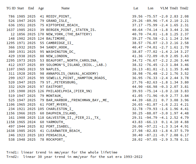
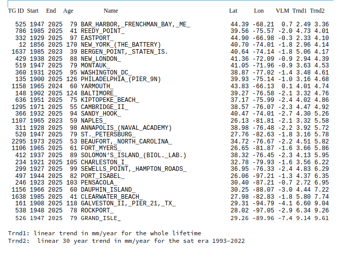
In the study we learn tectonic signals along 500 km of Chilean coast have been largely constant over the last 125,000 years. In other words, there has been negligible vertical land motion in this region.

As reliable indicators embedded in marine terraces clearly show Holocene relative sea levels were 3.2 m higher than today along this Chilean coast from about 7000 to 5500 years ago, it can be determined these highstands were a consequence of water-loading, or a warmer climate.

Image Source: Melnick et al., 2026

Another new study calls attention to the 1.76 m higher sea levels along the coasts of southeastern Australia 6000 years ago, falling to 0.59 m higher than today by 2000 years ago.

Australia is another region that would not be heavily impacted by glacio isostatic rebound, which again affirms these higher sea levels were linked to eustatic (climate-related) processes.

Image Source: Kennedy et al., 2026
The climate data they don't want you to find — free, to your inbox.
Join readers who get 5–8 new articles daily — no algorithms, no shadow bans.
5 9 votes
Article Rating
Subscribe
Notify of
28 Comments
spangled drongo
June 20, 2026 12:40 am

If only cli-sci would study this, along with the fact that when current vertical land movement is taken into account there is very little sea level rise happening today, and they just might accept that we don’t have any climate problem.

Bruce Cobb
Reply to  spangled drongo
June 20, 2026 12:51 am

But that would threaten the foundation of the Climate Industrial Complex, and many “climate scientists”, among others would be out of a job. How dare you!

Scissor
Reply to  Bruce Cobb
June 20, 2026 4:37 am

One word, “Microplastics.” That’s the ticket.

Reply to  spangled drongo
June 20, 2026 5:31 am

A great example is Battery Park. Its tide gauge shows about 2.9mm/year, but the actual sea level rise once subsidence is taken into account, is only about 0.7mm/year.

Bindidon
Reply to  spangled drongo
June 20, 2026 1:23 pm

” … along with the fact that when current vertical land movement is taken into account there is very little sea level rise happening today, … ”

Hmmmh. Methinks that who nicknames ‘spangled drongo’ very probably lives in a country hosting ‘Dicrurus bracteatus’, e.g. … Australia.

It is known that this continent exhibits stretches of coastline undergoing subsidence all around, ranging from Stony Point near Melbourne (-0.28 mm/year) to Fremantle near Perth (-3.14 mm/year).

Thus Australia looks wrt sea level quite like US’ East coast.

Would the drongo live near Churchill (Canada, Hudson Bay, +10.38 mm/yr) or Furuögrund (Sweden, Bothnian Gulf, +10.32) etc, maybe he would think different.
*
But this is not the point I want to discuss (anyway, the average land movement for all ~ 420 gauges I use to obtain a global figure is 0.06 mm/yr).
*
I read:

” A great example is Battery Park. Its tide gauge shows about 2.9mm/year, but the actual sea level rise once subsidence is taken into account, is only about 0.7mm/year. ”

*
Correct.

But… these two trends are for the period ‘1856-2025’. It therefore makes absolutely no sense to compare them to trends computed for the satellite-borne altimetry measurement era, i.e. 1993-2025.

Here is, for several gauges located at the US East coast, a comparison of lifetime to sat era trends when considering vertical land movement (VLM):

PSMSL tide gauges East Coast baselineable 1993 2022

comment image

But this list, however makes sense only when comparing a global, worldwide average of all available PSMSL tide gauges whose VLM context is known, to sat altimetry.

For the people living at the US East coast, what matters is what they experience in situ, i.e. without VLM correction:

PSMSL tide gauges East Coast no vlm

comment image

And… for each gauge in the list, you have to compute its quadratic fit for the sat era, which tells you how the sea level around the gauge might eventually look like in say 20 years due to the acceleration in tghe gauge’s data.

I know for example that despite having a very high linear trend, Galveston II has no acceleration at all since 1993.

Bindidon
Reply to  spangled drongo
June 20, 2026 2:38 pm

All these US East coast trends certainly will look insignificant to many, but.. they are a fact.

And above all, comparing the mid Holocene with at best 5 million Humans to the present with 8 billions and an incredible amount of near-coastal infrastructures: that’s simply childish.

MarkW
Reply to  Bindidon
June 20, 2026 2:41 pm

You want to compare the weight of a handful of houses to the weight of mile high glaciers, and you call others childish?

Bindidon
Reply to  MarkW
June 20, 2026 4:29 pm

” … the weight of a handful of houses… ”

What a stupid answer!

I guess you are even more childish than those who compared a 5 million humanity to the 8 billion Humans of today.

Look at the coasts all around the Globe, and try to identify how incredibly difficult it would be to displace industry, commerce and communication centres.

Where do you live? In the Rocky Mountains?

How wealthy are you?

Think before writing! It may be an experience.

MarkW
Reply to  Bindidon
June 20, 2026 8:28 pm

Are you really as desperate as your posts make you sound.

Reply to  Bindidon
June 20, 2026 10:04 pm

Most places fronting Port Jackson (aka Sydney Harbour) are at least 2-3m above the high water line.

At 0.75mm/year (as the high tide measured at Fort Denison indicates), sea level affecting these areas is some 2666 years away.

Are you scared now !!!!

Robertvd
Reply to  Bindidon
June 21, 2026 4:40 am

You should be afraid of a tsunami not sea level rise because of climate. How old are most of those cities and how big were they just 150 years ago ? And now tell me it would not be doable. And about industry those have all moved to China in less than 20 years.

Reply to  Bindidon
June 20, 2026 9:59 pm

The fact is that most of the relative sea level rise on the US East coast, is actually land subsidence.

Phillip Chalmers
June 20, 2026 2:32 am

All this talk about a sea level when the surfaces of the seas of the planet are different all the time. There is a moon dominated tidal wave sweeping the face of the planet 24/7 and the peak level at the leading edge changes continually throughout the solar year cycle.
Can any contributor point me to the methodology used to do the calculations in this study?

Reply to  Phillip Chalmers
June 20, 2026 8:16 am

Can any contributor point me to the methodology used to do the calculations in this study?

Did you follow the links?

Robertvd
June 20, 2026 3:50 am

7000 years ago is when Doggerland was drowned by the sea. Interesting.

Reply to  Robertvd
June 20, 2026 9:13 am

Yes I was going to mention that too. Also Cantre’r Gwaelod off the Welsh coast, a flooded forest dated about 5,000 years ago.
comment image

June 20, 2026 5:27 am

Same sort of platforms along the east coast of Australia show that sea level was a couple of metres higher than now, only a 1000-2000 years ago.

twofeathersuk
June 20, 2026 9:46 am

From the first paper:

“This peak has been referred to as the mid-Holocene highstand (HHS). Local sea-level
reconstructions revealed that the HHS was associated with very different amplitudes reaching > 10 m and ages that peak between ~ 8 and 3 ka5. This large spatial and temporal variability has been attributed to equatorial ocean syphoning and continental levering6, which may explain the observed HHS at low-latitudes”

No mention of temperature causing melting of ice causing the sea-level rise that I can see. Sea-level has gone up and down in the past (especially at low-latitudes), possibly over many thousands of years. Now we’re likely to see multiple metres of sea-level rise in hundreds of years – possibly quicker. A big difference in rate.

From the article:
Higher sea levels were due to a warmer climate, or the consequence of more water in ocean basins rather than locked up on land as ice.” Any evidence in the papers for that statement? Not quite sure what the ‘or’ is doing there. If there was a warmer climate then you would expect less ice on land.

MarkW
Reply to  twofeathersuk
June 20, 2026 11:02 am

Melting ice and thermal expansion are the only possible source for that much extra water.

twofeathersuk
Reply to  MarkW
June 20, 2026 3:02 pm

The main drivers of sea-level rise in equatorial locations are (in order of effect) and speed of impact:

1) Melting of land based ice into ocean (e.g. Laurentide ice sheet): Moderate
2) Equatorial ocean siphoning due to polar ice mass increase: Slow
3) Reduced gravitational pull of melting polar ice mass: Moderate
4) Thermal expansion: Fast

At the end of last ice age, 1) would dominate, raising sea-levels in equatorial regions. Presumably reaching a maximum around the mid-holocene. After some time the sea-level would start to fall because reduced polar ice mass would siphon water away from equatorial regions (2). This has been happening for the last few thousand years. Anthropogenic warming has now kicked in, first with 4) and increasingly with 1) so that sea-level will start to rise again.

It’s not just the amount of sea water but also where the volume is located on the Earth’s surface.

But the author most probably knows all this. But they dropped a hint in the article that the high sea-levels measured in mid-Holocene were due to high temperatures (in a sentence that looks like it was meant to say something else but was mangled in the editing process) and then relied on the WUWT readership to be gullible enough to immediately jump to the conclusion that this is more evidence that the temps in mid-Holocene were higher than today. See how this works? They think you’re stupid and will fall for plays like this. Fool you once, shame on them, fool you twice, shame on you.

Once a comment like this goes up, debunking the story and showing it up for what it is, they’ll quickly post another story to move the discussion and focus on somewhere else. The methods and grift are so obvious it’s dumb-founding.

Reply to  twofeathersuk
June 20, 2026 9:56 pm

No, we are not stupid, so we don’t fall for random data-unfounded, and logically incoherent rantings like yours.

“reduced polar ice mass would siphon water away from equatorial regions”

Say what ?? There is more polar ice now than for most of the last 10,000 years.

“Anthropogenic warming has now kicked in”

BS… The only anthropogenic warming is in expanding urban areas. This does not effect sea levels.

Sea levels have been rising at a small, basically linear rate of around 1-2mm/year for well on 100+ years.. Nothing to do with CO2.

Jeff Alberts
Reply to  twofeathersuk
June 20, 2026 7:07 pm

Now we’re likely to see multiple metres of sea-level rise in hundreds of years – possibly quicker.”

Assuming a rate of 3mm per year, it would take approx 1667 years to reach 5 meters of sea level rise from today.

Reply to  Jeff Alberts
June 20, 2026 9:57 pm

And the actual rate is really somewhere nearer 2mm/ year, making it some 2500 years to get 5m of sea level rise.

MarkW
June 20, 2026 9:54 am

And to think Simon is still proclaiming that there is no evidence that the Holocene was ever warmer than today.

Phillip Chalmers
June 20, 2026 5:27 pm

All this talk about a sea level when the surfaces of the seas of the planet are different all the time. There is a moon dominated tidal wave sweeping the face of the planet 24/7 and the peak level at the leading edge changes continually throughout the solar year cycle.
Can any contributor point me to the methodology used to do the calculations in this study?
The first sentence contains “assumed” without even a brief mention how this area represents the whole

June 20, 2026 8:27 pm

Here’s a different sea level rise they missed: https://m.youtube.com/watch?v=DopB8CtSn3E

ferdberple
June 21, 2026 9:32 am

1.76 m higher sea levels along the coasts of southeastern Australia 6000 years ago, falling to 0.59 m higher than today
=========
The Great Flood. Killed all the coral and humans shorter than 1.76m. Climate Change. Taught humans to stand up straight.

ferdberple
June 21, 2026 9:45 am

Worries about Sea Level Rise have allowed climate scientists and politicians to snap up some real bargains in waterfront property.