From the Cliff Mass Weather Blog
Dr. Cliff Mass
You knew it was colder than normal over the Pacific Northwest during April.
But the cold was not limited to the surface. Let me show you the chilly story in a very new way: using satellite temperature soundings in the vertical.
By measuring infrared or microwave radiation emitted by the atmosphere, satellites can measure how temperature varies in the vertical. Not unlike how infrared ear thermometers work by sensing the radiation emitted by your eardrum!
Below are the differences from normal of the April temperatures in the lowest 10 km (lowest 33, 000 ft) of the atmosphere, with normal being the average for 1991 through 2020.
Blues are colder than normal and yellow/oranges are warmer than normal. This map and associated data were provided by Professor John Christy of the University of Alabama, who is a well-known expert in such work.
The coldest temperature anomalies (differences from normal) over the entire planet are found the Pacific Northwest, with the deviations from normal exceeding 2.5 C! (4.5F). A blow-up for the Northwest is shown below.


But there is another point you need to consider: there are all kinds of temperature anomalies all over the planet, including a major warm anomaly over Kazakstan.
Differences from normal, both warm and cold, are….well…normal. These patterns occur naturally as troughs (low pressure) and ridges (high pressure) move and develop.
But there is more! This cold anomaly over the Northwest is the COLDEST ever observed since the beginning of satellite temperatures collection (1979). This is shown in the plot below.

You will also notice something that else that is very important…there is little long-term trend for April temperatures over our region. This is consistent with the observation that our snowpack has shown little long-term trend over the region.
May is Not Any Better
And now the depressing part. May is also turning out to be cool….and wet.
At Sea Tac Airport, every day but one in May has been below normal, with highs on many days around TEN DEGREES below normal.

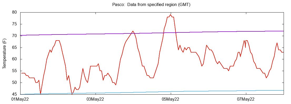
Slightly better in eastern WA, with Pasco’s temperature reaching normal highs twice this month.

The silver lining in all of this is that with lots of precipitation and cold temperatures, the snowpack has surged to well above normal for the entire state (see below). Late ski season. Delays wildfire season. Lots of water for the summer.

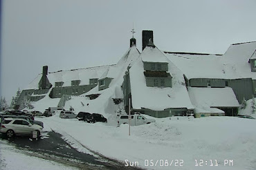
During the last 24 hour, NINETEEN INCHES of snow has fallen at Timberline Lodge on the slopes of Mt. Hood. Amazing.
And now the REALLY depressing news for lovers of warmth. The latest European Center ensemble forecast for the next ten days predicts MUCH cooler than normal temperatures over the region.

No wonder my tomato plants are unhappy……

Imagine if climate scientists and their ilk were treated like the snake oil salesman Mr Meriweather in Little Big Man, would only the torso remain?
Global temperature for April in the same level of the atmosphere according to the same dataset (UAH v6 lower troposphere) was .26 degree C warmer than the 1991-2020 baseline of this dataset, warmest in the past 6 months. https://www.drroyspencer.com/2022/05/uah-global-temperature-update-for-april-2022-0-26-deg-c/
Texas and New Mexico are roasting now under a sustained high pressure ridge. The sustained LaNina is likely causal to this pattern.
A whole article about cold weather. Why is there no mention of the record setting heat wave in India/Pakistan happening now?
It did mention it, and it shows up in the map above.
Record setting heat? We had some of that last year, remember? Even with that they could only declare it the 7th hottest year ever, meaning whatever heat waves we had there was even more cold.
Right?
It’s not “record setting”.
https://realclimatescience.com/2022/05/cnn-normal-weather-is-a-climate-crisis/
In India, a very strong monsoon season will start along with the tropical cyclone. La Niña has pushed all the warm water into the Indian Ocean. The surface temperature of the Indian Ocean reaches 31 degrees C over large areas. Since the ocean surface cannot exceed this temperature, the ocean will release huge amounts of water vapor. Numerous tropical cyclones are formed.
Absolute rubbish – highs are around 44C; that is nowhere near ‘record setting’ for pre-monsoon weather in India – if the temperatures go over 50C then we can take a closer look at the records but not until then. The shallow end of the media gene pool has once again been seething with unfounded and misleading fake weather news – don’t buy into it, it’s all B.S.
This could be the 22nd warmest year on record in the Pacific Northwest, at least according to the weekly talking points guide sheet of the paid agenda troll network. Isn’t that right Griff.
Let’s ask Christopher Steele also.
although it was a mild winter for North America (wasn’t it?), the spring has been mild, if not a bit downright chilly…
Mr. Ice Age please don’t start anytime soon (human time, not geological).
..in Denmark we haven’t had a day yet where temperatures reached 20c (Tmax). A few days ago it was 23 years ago we last had to wait so long – the record being 2. june 1873 – ( the early record being 18. march 1990.)
A linear regression based on max temperatures tells me that spring has become approx. 1/2 degree colder the last 15 years pushing spring forward in the calender by 14 days. Tree leaf out hasn’t changed either the last 15 years.
It’s getting colder – and it has been like that for a while now.
Just for Information: Southern Stevens County, NE Wash. State… stopped burning wood in March.. back to burning this week and last… nighttime temps. to be near freezing tonight and tomorrow at least… very little garden planting done yet, and apprehensive about the Peach trees and sweet Cherries, which are in full bloom… likely will get up before the Sun, and spray water, in hopes that will get them through to “set”… have never kept any written records of temps. at this time of year, but it does seem cooler.
It’s still very cold here in the mid-Atlantic states. It was 38 degrees F this morning, May 9. We’re practically at the longest daylight period of the year – it’s 8:02 pm Eastern Time, and still light outside. This entire spring has been just like today, but all I read is that it’s “the hottest on record.” I call BS on that.
Seemed pretty normal to me on Whidbey Island. 50s F.
Everything is just WAY too over-scrutinized. Every little blip is a major thing, no matter which camp you’re in. It’s all rather silly.
and in India and Pakistan?
which are apparently invisible to Watts?
As you can see, La Niña is going strong.
Has Mann paid his 25 million dollar judgement – yet?
It’s called ‘weather’ – couldn’t forecast it 200 years ago – can’t forecast today with all the technology at hand – this and COVID – y’all are a laughing stock.
In the Pacific North West we keep hearing from UBC on how the ice wine industry will soon be destroyed.
I’d be curious in seeing every month of data for the PNW. According to April, the summers don’t seem to be getting any longer in this part of the world.