Reposted from the Cliff Mass Weather Blog
A major hurricane is hitting the Gulf at just the wrong place for New Orleans and environs.
Hurricane Ida, a category four hurricane with winds gusting to 150 mph is now making landfall.
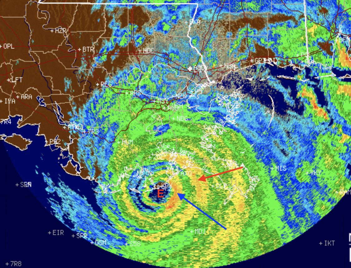
The latest weather radar image (showing intensity of precipitation) clearly shows the eye of the storm (letter E!), just making landfall on the Lousiana coast (below).

Ida has a compact eye, with the eyewall apparent in the precipitation band indicated by the blue arrow. A secondary eyewall appears to be forming (red arrow), which is temporarily weakening the storm (it might have become a category five storm if the second eyewall did not start to form.
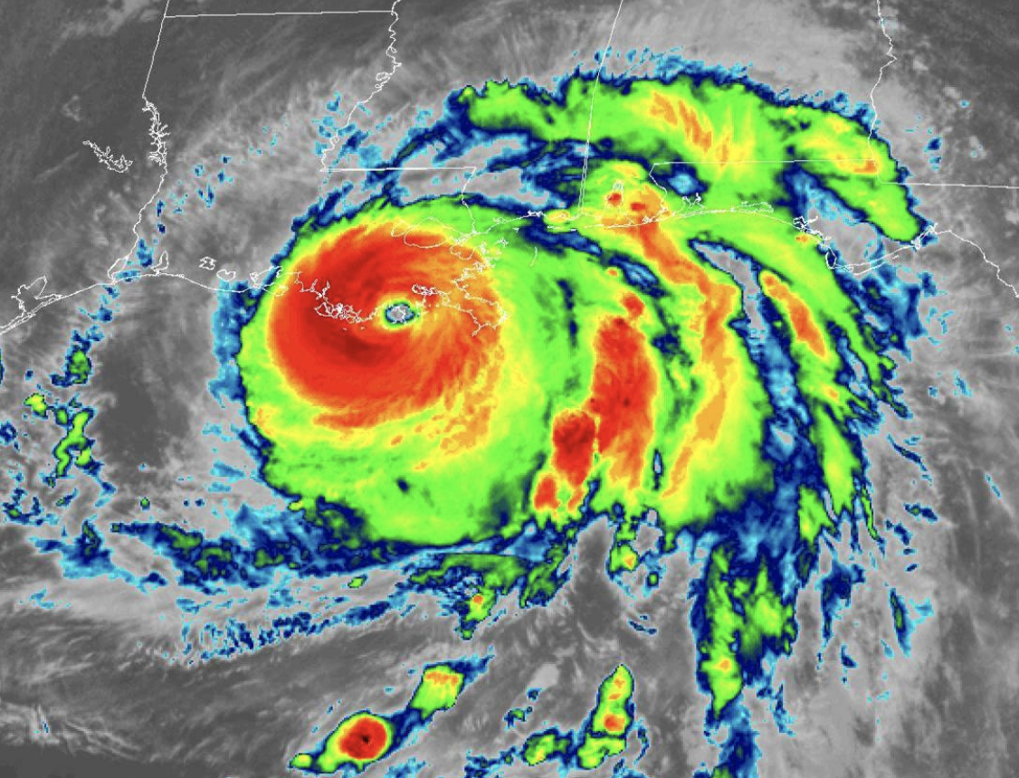
The infrared satellite picture (which is essentially providing the temperature of the clouds and surface) is impressive– the eye is small, but well defined, with high clouds (red colors) surrounding it.

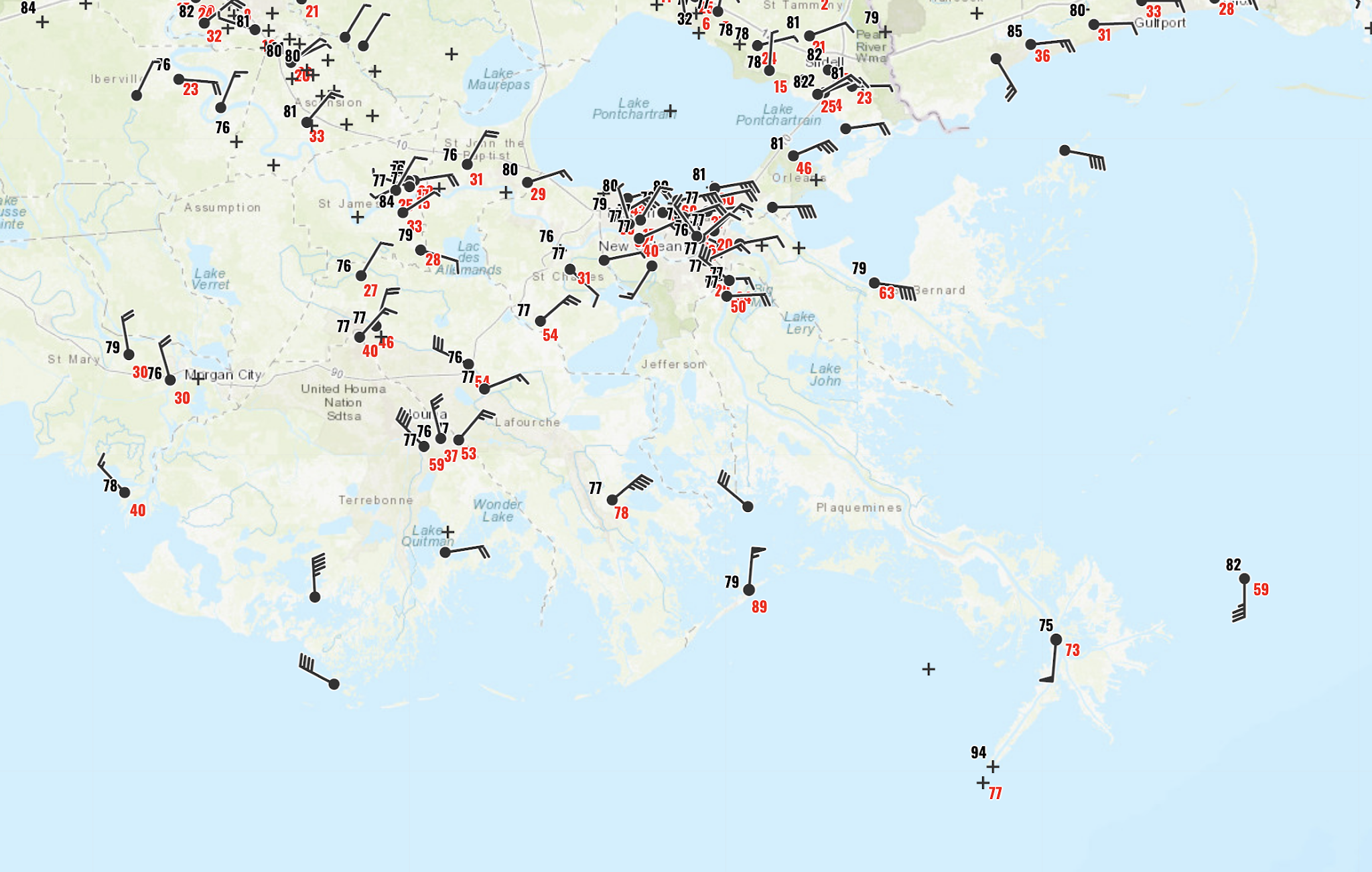
The small size of the eye is a very good thing because the strongest winds are limited to the area in the eyewall of the storm. Here are the latest wind reports (10AM), with the gusts shown in red (click on image to expand). Gusts to 89 mph. Note the strong easterly (from the east) winds moving towards Lake Pontchartrain and New Orleans. Not good…pushes water onto land in the form of a storm surge.

Maximum winds gusts so far (see below) have ranged as high as 128 mph

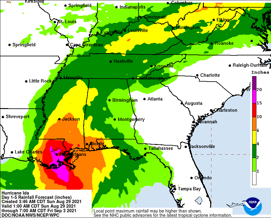
The storm will weaken as it moves over land, but extremely heavy precipitation can be expected, with totals reaching 15-20 inches in southern Lousiana and large rainfall totals extending into the Northeast U.S. (see NOAA/NWS forecast below)

Predictability of the Storm
The forecast of Hurricane Ida is classic: extremely good forecasts for the storm track many days out, but the forecast of the storm intensity (central pressure and maximum winds) underplayed the storm.
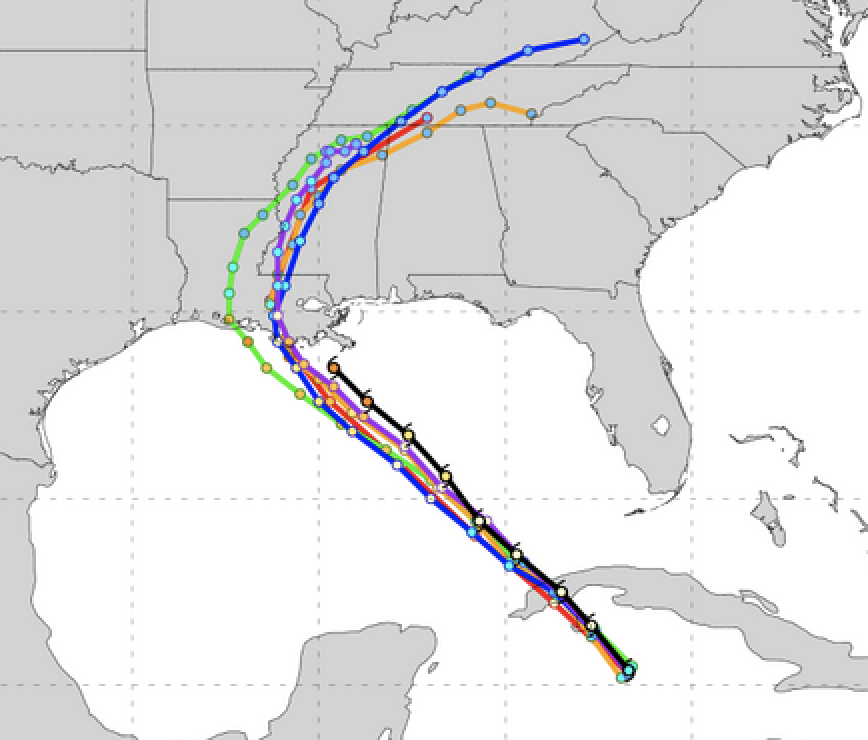
The forecast tracks of major U.S. and Canadian models on Friday morning were quite good, but were slightly too much to the west. (black line shows the observed track).

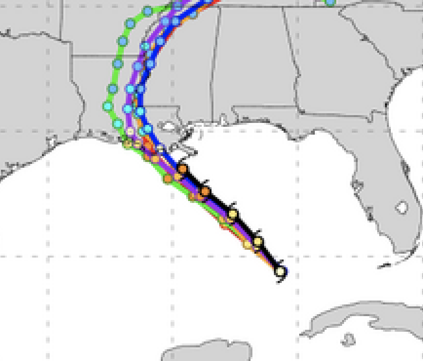
By yesterday morning, the track forecast was excellent.

But what about the intensity forecast on Friday? One measure of intensity is the central pressure of the storm (the lower the pressure, the more intense). The latest observations indicate the low center is down to 930 hPa (hPa is a unit of pressure). Here are the forecasts from yesterday morning (black line indicates the observed). None of the forecasts got the storm deep enough. As a result, their winds forecasts have been too low.

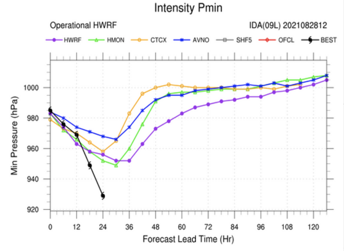
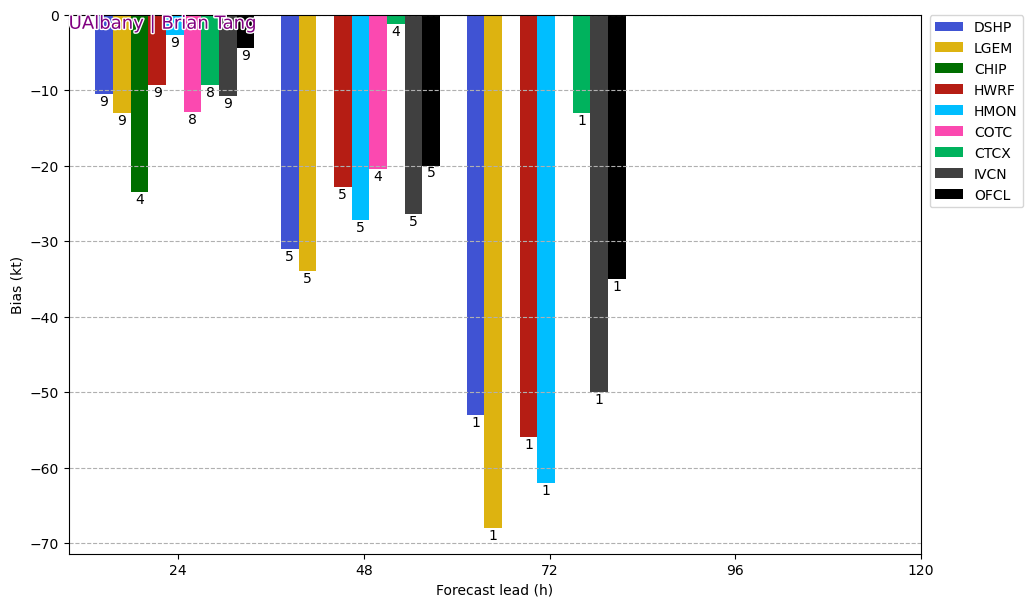
As shown by this graphic by Dr. Brian Tang, University of Albany, the winds were about 25 knots too slow for the 47 hr forecast and about 50 knots too slow for the 72 h forecast.

Why are our models frequently unable to get the intensification right? One reason is the lack of resolution. To simulate such storms one needs to simulate the hurricanes with model grid spacing of approximately one kilometer or better, but the National Weather Service lacks the computer resources to do so.
Then there are deficiencies in model physics, such as how sea spray humidifies the air above the breaking waves. Or how cooler water mixes vertically in the upper ocean surface.

And then this the need for model data to describe hurricane structure offshore.
An apparently significant issue for Hurricane Ida was a patch of deep warm water over the Gulf of Mexico, directly on the track of the storm (see below). Such warm water greatly helps a storm to intensify.

Finally, one thing to keep in mind: our ability to predict the tracks, and to a less extent the intensity of hurricanes, is a potent tool for reducing damage and casualties from tropical storms and hurricanes.
It is why tropical storm deaths are far fewer today than 50-100 years ago, even with many more people on the planet.
Will there be a significant storm surge from Ida?
I believe so. IIRC the NOAA were predicting up to 2 metres
I saw some videos that looked pretty close to that. Four feet up a wall in a building that was a little above sea level, at least.
See here.
Inundation Dashboard – NOAA Tides & Currents
From a news report
“Below are some of the peak surge values observed through 2:30 p.m. CDT Sunday. Higher values can be expected in some locations later on Sunday, especially from New Orleans eastward.
3.6′ at Port Fouchon, LA;
5.6′ at Grande Isle, LA;
4.4′ at Pilottown, LA;
7.6′ at Shell Beach, LA;
3.0′ at New Canal Station, LA;
6.4′ at Bay Waveland, MS;
4.1′ at Pascagoula, MS;
3.2′ at Dauphin Island, AL.”
I was trying to find information on CBSN Bay Area (FIRES) and the meteorologist just said that climate change caused Hurricane IDA and the South Lake Tahoe Caldor forest fire. He showed side by side videos of both and said that hurricanes are now more intense, and that hurricanes are 10 times more expected to have a short term (24 hour) intensification than just decades ago, it was not so.
Liar!!!
He even showed a graph/chart which showed Atlantic hurricanes have intensified since 1972 – don’t know where he got that.
Also, he said that the Caldor forest fire was caused by climate change – both a complete lie which can be shown by actual DATA.
He kept repeating that Ida and the Caldor fire had both been caused by climate change. Boy is he drinking the cool aid?
Intensity has so many variables it will always be hard to gauge. NWS did a good job on this one even though it made landfall sooner than they were calling for. I was in contact with my family in Pearl River county MS and they still have power. Have not heard from cousin and nephew in Barataria area, hope Cass’ satphone gets through this morning some time.
The intensification seen by Ida correlates to the G1 (minor) Geomagnetic storm conditions in the previous 24 hrs. Landfall was 29 August, with station K and Kp indices at 4 or above in previous 24 hrs, 28 August.
Joel, are you going to give us an article about the relationship between hurricanes and geomagnetic storms?
I’d like to see that, too, if you don’t mind!
Bollox!
“Maximum winds gusts so far (see below) have ranged as high as 128 mph”
So not an actual Cat 4 hurricane. Hurricane categorization is based on sustained winds, not gusts. If gusts only reached 128 mph, sustained would be lower. To be a Cat 4 hurricane the one-minute-average maximum sustained winds at 10 meters above ground level would need to be in the range of 130-156mph. This was a Cat 3 at best for landfall.
It all looks like pretty standard fare for a hurricane hitting this area. Nothing particularly abnormal or special about it. Yeah, it sucks for the people having to deal with it, but the gulf coast has to deal with hurricanes on a fairly regular basis since time immemorial. The hyping of regular and normal weather events needs to stop.
Greg S, I certainly agree with your call to stop hyping weather events, but am a little conflicted about evacuations along a projected hurricane path. Unless you have an unusually resistant structure, well above predicted storm surge, you should evacuate in an orderly fashion and not wait for the rising water and winds to force you out. I was trapped in a tower in Viet Nam, in July 1969, when a typhoon came over us, where the sustained wind speed was 111 knots (127 mph), which is not an official wind speed as the wind gauge was about 25 meters above ground level. The howling of the wind, the shaking of the tower, and the torrential rain would frighten a normal person, like the “young” guy in the tower with me.
What little news is getting out to the UK MSM suggests no issues with levees this time. Flooding and loss of power seems to be the greatest impact, plus blocked roads and debris from building damage
There is no way Ida compared to Katrina which was a massive storm that filled the entire gulf. Katrina was when I learned about the gulf loop and what happens when a huriicane sits over it.
As for the historical record of hurricane in this region…
From
https://www.thecajuns.com/lahurricanes.htm#Menu
Interesting read
1860: Number 1, August 11th On the fourth anniversary of the Last Island disaster, another hurricane made landfall in Southeast Louisiana. The Mississippi rose 3 feet during the storm. The old site of Proctorville, now Yscolski, had hardly a house left standing… its lighthouse also leveled. The Bayou St. John lighthouse was destroyed. The Cat Island lighthouse was demolished, along with its keeper’s dwelling. The Island was inundated, causing the loss of 300 cows. Storm surges extended eastward along the entire Mississippi coast. The sugarcane crop laid in ruin. Trees were uprooted throughout the Plaquemines and Balize (Pilottown). Up to ten feet of water inundated the region. Crops of rice and corn were entirely ruined. The influence of the storm extended eastward to Pensacola, where it rained 3.03″ and a strong gale ensued on the 11th. Over 47 people died…damaged totaled $260,000.
Return to Menu
1860: Number 2, September 14-15th Another hurricane struck near the Mouth of the Mississippi, worst at Balize (Pilottown, Pilotsville). The gale raged for about 20 hours across extreme Southeast Louisiana, and large hail fell. Every building in Balize was either blown down by the wind or washed away by the storm surge. The third Bayou St. John lighthouse was damaged beyond repair. Lower portions of Plaquemines parish were covered by several feet of water, drowning several people. Tides rose to 6 feet above the high tide mark. All wharves along the south side of Lake Pontchartrain were destroyed. But it was no better in Mississippi…the lighthouse at Bay St. Louis was swept away along with one of its hotels. In total, damages exceeded $1 million.
Return to Menu
1860: Number 3, October 2-3rd A third hurricane within seven weeks produced severe damage to houses, businesses, boats, and crops as far inland as Baton Rouge. The storm made landfall in the Atchafalaya Swamp and swept northeast. It only carried with it a 12 to 15 inch storm surge at Port a la Hache, likely due to its rapid movement. Whatever was left of the sugar crop, along with the machinery employed in producing it, laid in ruin. Heavy losses were reported in Vermilion, Feliciana, Alvermarle, Bayou Lafourche, Pointe Coupee, St. Bernards, and Terrebonne as well. Eleven miles of railroad track were washed out near New Orleans, where the rain total was 5.02″ during the storm. The system continued northeast and produced the highest winds Natchez had seen since the Tornado of 1840. Trees fell in great numbers in Concordia Parish as they experienced stiff north winds. Gales were seen eastward to Pensacola, as with the first storm in 1860
Anyone who lives on low ground along the gulf stream anywhere can expect to walk away with nothing except what they have on their backs at least once or twice in their lives.
And this was LONG, LONG before anyone ever heard about ‘Climate Warming’! The odds are very good (bad?) that this has been going on since way BEFORE that time, too! Weather happens, and Man (luckily) can’t do much, if anything, about it! Except curse it and move on!
Thanks for the link. Loop Current favors Louisiana. Katrina was bad, took out Pilottown again (had minor storm refuge there once) old Chandeleur Lighthouse, lots of platform damage. 1915 with two was bad also, 13′ reported in Pontchartrain.
If you navigate over to the NOAA “hurricane history” webpage, they list all of the major hurricanes to landfall in the USA, and most of the really bad storms happened in and prior to the mid-1930s. The worst hurricane of all, in terms of loss of life and property damage, was the 1900 Galveston hurricane. Other notable hurricanes causing widescale flooding and loss of live include the1926, 1928, and 1935 hurricanes that landfalled in South Florida. Katrina of course caused massive damage and loss of life, but far below that of Galveston or the three South Florida hurricanes.
Thank you for link comments. On deeper history did you know kamakazi means Devine Wind and refers to a pair of typhoons that destroyed the Mongol fleet invading Japan.
https://www.britannica.com/event/kamikaze-of-1274-and-1281
1274 and 1281
Interested in how tropical storms have dominated history
Reports out of Port Fourchon have unverified winds clocked at 149 mph sustained, with a gust to 172mph from the instrumentation on the Seacor Eagle ship there.
I wonder what the elevation of the sensor is? Looking at a picture of the lift boat probably 50 ft or so.
Yeah, maybe higher…20 meters?
The NOAA weather station on Grand Isle, just to the west of Fourchon, recorded maximum sustained winds of 65 kts and gusts of 95 kts.
The NOAA station at the mouth of the Mississippi River recorded maximum gusts of 105 kts and sustained 90 kts. It is much farther from the eye than the Grand Isle but the sensor is 38 meters elevation whereas the GI sensor is less than 10 meters.
Some people may be led astray by mixing up mhp and knots in the same discussion.
1 knot is 1 nautical mph, so about one and one seventh mph.
So 105 knots is about 121 mph.
SFMR measurements were 130 kt. There was an anemometer reading that recorded 130 kts as well. That is a bit unusual since they don’t typically survive those kinds of winds so that observation is preliminary.
I saw a report that an anemometer broke after recording a gust over 145mph.
This comports with what has occurred in other intense storms.
It is important to realize that the max winds in a storm does not mean those winds exist all the way around the center.
It means one spot has been found with winds that high.
It has to also be noted that standards for reporting max and sustained winds is not what it used to be.
It seems the numbers are always higher these days than would have been the case in years past with the same storm.
Having said that, this seems to be one case where there actually were winds recorded that were in the neighborhood of what the official bulletins reported.
With Irma, for example, I never have found any wind report that was measured, that came close to what has been recorded as the official winds in the system.
Interestingly, On SkyVector, an aviation meteo website, the METAR/TAF’s for the New Orleans area airports reported maximum gusts of 68kts. The highest wind being 55kts.
Why is that?
When my wife and I first married, in Palm Bay Florida, in 1979, we had a hurricane go through. We decided to sit it out, rather cautiously. The eye ended up passing right over the house we were renting. During the time that it took for the leading edge to pass by and the trailing edge to depart, the wind speeds varied from very little to a ‘lot’. As the eye passed over, there was basically NO WIND! The sun was shining, in fact! Then the trailing edge passed, and again there was very little wind. I was going to suggest that it matters where you are, but we experienced the entire storm. Once it was over, the next day, we ventured out to see what the damages were, and they were extensive in Palm Bay, and included a tornado or two! To sum up, the winds CAN vary significantly!
That matches with several data logs from weather buoys just off the coast in the path of Ida. I could find gusts in the 70-80kts range but nothing higher. I wish they would not report winds aloft. https://www.ndbc.noaa.gov/
New Orleans is well inland, and the eye did not pass over the city.
By the time the eye approached the area of New Orleans, it had been over land for many hours.
Max sustained winds does not mean everyone in the area affected will get those winds.
Luckily.
The barometer is a good indication of intensity, and can and often does remove some of the uncertainty associated with spotty coverage of anemometers.
This was obviously an intense hurricane, as can be seen in the satellite and radar presentations, barometric pressure, and some of the (spotty) wind readings.
This was a very tight hurricane eye, and wind measurements are very imprecise, both in measurement (instrument) performance and in terms of areal distribution. The very skinny eyewall is easily missed at any given anemometer location, and the precise definition of “windspeed at landfall” would be the eyewall windspeed measured at the nearest point on a circular arc that barely touches land. As soon as the eyewall begins to touch land it immediately loses driving energy.
Anemometers aren’t very precise or reliable, and in fact they tend to fail in high winds. The eye of Wilma went right over my house, and my next door neighbor’s anemometer failed at its last reported measurement of 131 mph … so we can’t really tell what either the peak gust or 1 minute sustained winds were for that storm at my house.
This is why tropical cyclones are best measured by minimum eye barometric pressure – much more precise and reliable instruments are available than for anemometers, and the interior pressure is experienced across a much broader and larger area.
The hindsight on this one could well be applied to the cost-benefit of stringing ALL your utility cables on poles, rather than the harder job of undergrounding them…
I am not sure about the wisdom of running utilities underground in a region that is at or below sea-level. Water rots the insulation of conductors. Even for direct burial cables, long term exposure to water will do it’s damage. I think it would be a trade-off between costs of rerunning overhead lines and poles after major storms versus running underground and rerunning cable every few years to prevent line failures from rot.
But sub-sea communication and power cables have been around for many decades. The first transatlantic telegraph cable came into service in 1858, to be followed by many more as technologies improved. The UK is connected to mainland Europe by several inter-connector power cables carrying anything up to 2GW.
Underground power cables are well insulated and do not ‘rot’: the technology is well developed. Telephone lines are in fact more prone as they have joints in them that are subject to corrosion if water gets to them, and it does!
Optical fibre doesnt give a damn 🙂
I have repulled many cables in conduit between buildings. The water filled conduits did rot the outer jackets of the multiconductor cables and the interior insulation was brittle. A few more years and it would have shorted out. Deep sea cables have an entirely different jacketing material and voltage insulation rating. They also rely on the ocean to dissipate heat. The costs of using those types of cables on land for local distribution cables would not be recoverable in the lifecycle of the local grid.
More to it than just the last drop being buried. The image below is a good summary. Some thoughts:
500KV transmission lines underground require substantial property and probably substantial protection knowing how people dig.
Distribution lines can be from 4KV in residential neighborhoods to 70KV in mixed and commercial areas. Protection from digging will be needed for the HV distribution lines.
Water damage from flooding and storm surge into ground mounted transformers and on into associated buried lines is really much harder to repair than above ground lines.
Telephone companies learned early on that pressurized conduits were required for major trunk lines. Water is almost like hydrogen in its ability to find voids and weak spots to intrude thru.
Remember, if a HV transmission line fails everything after it fails. If a HV distribution line fails, everything after it fails too. And, on down the line. HV lines are nothing to mess with. They can literally reach out and grab you. Go onto youtube and look up Tesla coil demo. I know these are different, but if you’ve never seen a 50KV line arc when a switch is opened, you have no idea the kind of power you are dealing with.
There is very little of “below sea level” in developed areas. Even if there is an area below sea level, it will end up being continuously pumped to draw down groundwater to at least several feet below ground surface, unless it’s a swamp, in which case it’s not developed anyway.
I live within a half mile of a Gulf Coast estuary – my house sits at 16 ft above MSL. No electrical or telecom lines are run more than a couple feet below grade.
Electrical wiring under 600V is installed at 18″ deep and higher voltages are at least 36″. Based on what I saw in commercial/industrial construction high voltage (>15k) was closer to 2 or 3 meters deep, but that may have been just the location to avoid all the other underground utilities. According to the following linked paper, 36″ deep is common and spread out in multiple parallel lines.
“To match overhead line thermal performance for a 400kV double circuit, as many as 12 separate cables in four separate trenches may be needed, resulting in a work area up to 65m wide. ”
39111-Undergrounding_high_voltage_electricity_transmission_lines_The_technical_issues_INT.pdf (nationalgrid.com)
I did an BMS survey of the Spanish Fort High School in Spanish Fort, AL about 16 years ago. They had installed a very large ground source heat pump system for the entire schools heating/cooling load and could not install it to the recommended depth because of the high water table and shallow bedrock level, so the loops were installed relatively shallow and spread out over a large area. Later someone approved to install a parking lot over the top of it on the north side.
high school – Google Maps
At some point after the parking lot was poured, the heat pipes clogged, collapsed, or corroded and about 60% of the heat transfer capacity was lost. Since they did not know which loops had failed or where along the pathway the problems started, there was not a viable way to fix it without digging up the parking lot.
I expect NOAA/NHC will be under some political pressure to post hoc upgrade Ida to Cat 5. They justify re-catagorization using some obscure methodological data reanalysis, i. e. hocus-pocus. NHC did this with 2018 Hurricane Michael. They “found” some wind reading somewhere of 160 mph to reclassify it to Cat 5.
Pages 4-6 in this report:
https://www.nhc.noaa.gov/data/tcr/AL142018_Michael.pdf
describe the Dark Arts used to “upgrade” Michael’s surface winds to > 155 mph needed for a Cat5. Note: > 155 mph surface winds were never actually measured just estimated based on radar and satellite data.
SFMR measurements of Michael were 138 kts.
Being a government entity, their primary interest is in maintaining their funding! They have to show they are doing useful ‘work’, else they could be dismantled! Just sayin…
“upgrade Ida to Cat 5”
I heard a report right after landfall that it was “1 MPH short of Cat 5”
Well, it didn’t take them long…
https://www.commondreams.org/news/2021/08/30/hurricane-ida-deemed-poster-child-climate-disaster-storm-slams-louisiana-0
Climate Liar par excellence Eric Holthaus moans: “As New Orleans fills with water once again from another once-a-century storm, remember that fossil fuel executives knew about climate change decades ago and decided they’d rather be rich than have a habitable planet.”
Yes, the Climate Liars are surely champing at the bit on this one. Fits the ideology like a glove.
New Orleans only received Cat 1 force winds in Katrina – hardly a “storm of the century” as tropical cyclones go. What failed in NO were the poorly constructed and poorly maintained levies, which could not handle the rainfall not only in N.O. but upstream in the Mississippi delta.
The strongest winds, Cat 4 and 5, were experienced far to the east in MS, AL, and FL.
And yet, nowhere in this article does anyone claim or offer any evidence that the portion of human released CO2 in the atmosphere and its associated back radiation is capable of warming seawater by any amount.
It is the ocean temperature that powers the heat engines known as hurricanes , is it not?
I would note that Ida made landfall the exact same day that Katrina did 16 years ago. Nearly the same location too. Ida also went over the same warm pool loop current that supported the RI for Katrina.
Nope – Ida’s center as it landfalled was well to the west of New Orleans, while Katrina’s eyewall landfalled a very long distance in the opposite direction, in MS. The strongest winds from Katrina were experienced in MS, AL, and FL, not LA or N.O.
Ida was pretty run of the mill as hurricanes go, although it had some things going for it. Conditions for it to form and strengthen coming off Cuba were pretty ideal. Not a lot of shear and over the deep, warm waters of the loop current.
What was remarkable was it strengthened right into landfall. Some of it might be attributed to the low level Mississippi Delta land which contains a lot of warm marsh water and nothing to really disrupt airflow. Also there wasn’t a lot of dry air drawn into it as it approached land, which can be a big disruptor. And thirdly the geomagnetic conditions were ripe for intensification. One thing is for sure.. it was no Camille, which is the benchmark GOM hurricane of the past almost 50 years. Camille floated oil rig supply ships 3 miles inland and kind of got the ball finally rolling on hurricane preplanning.
The BBC has nothing to say on this, so it isn’t out of the ordinary, I would imagine
The Conversation has an helpful article…
“How students can use storytelling to bring the dangers of climate change to life”
https://theconversation.com/how-students-can-use-storytelling-to-bring-the-dangers-of-climate-change-to-life-166693
That should be easy. Klimate Kluckers love telling stories about climate. Along the lines of most any fairy tale should do nicely. Once upon a time, there was a beautiful planet named Gaia, who was very happy. Everything was in balance, including the climate. She had worked long and hard to get it that way, so was very proud as well. Then along came Man with his evil fossil fuels, threatening to ruin everything, and Gaia became very sad. And so forth. It writes itself.
Almost as cynical as I am….
Even the Beeb couldn’t hype it up
Flood threat in southeastern US as Ida is blocked from the north by highs.
https://www.accuweather.com/en/us/birmingham/35203/weather-radar/346630
https://www.blitzortung.org/en/PHP/make_maps.php?parameter_file=Tmp/query_data_1630339128
Actually the flood threat isn’t the SE US, it’s north of TN and southern Virginia up into the northeast US. The Bermuda high is forcing it out of the southeast up into the metro areas of Washington DC/Philadelphia/New York/Boston
I disagree. The southeastern US is at risk.
I live in the Southeast US and we are NOT AT RISK. There is the first real cold front of the season coming through Wednesday and some of the residual moisture from Ida may supplement the front, but right now it doesn’t look like anything. Atlanta which is closer to the storm is forecast 10-20 mph winds and the possibility of 1+” of rain. Charleston SC is basically nothing.
There are no warnings out for anything from the National Weather Service.
The center of the storm remains over Mississippi, with rainfall slowly moving into Alabama. I’m warning you.
Watch the radar.
https://www.accuweather.com/en/us/atlanta/30303/weather-radar/348181
Ida is moving east and dragging its tail from the Gulf of Mexico.
https://www.tropicaltidbits.com/sat/satlooper.php?region=atlpac-wide&product=wv-mid
You have a strange definition of “east”. According to the map in your link, Tennessee is north of Alabama.
Missing graphics can be coaxed out of hiding by multiple applications of the F5 key.
Thank you for the F5
Quote:”An apparently significant issue for Hurricane Ida was a patch of deep warm water over the Gulf of Mexico, directly on the track of the storm (see below). Such warm water greatly helps a storm to intensify.”
That’s nice innit. It’s just dawned here, in this corner, that if you could ‘plough’ the ocean similar to ploughing land – you could have ‘buried’ that warm water.
To an extent it would either weaken/k!ll the thing outright or you could maybe steer it ‘somewhere else’
(Remind me, where’a Al Gore’s seaside mansion. Sorry Al, The Computer made us do it)
That would be a curiosity the some significance, ploughing.
How ploughing of dirt/soil/land sets off inclement weather, but if you ploughed the ocean, you could calm the weather
nice
earth :: a global map of wind, weather, and ocean conditions (nullschool.net)
This is the first time I noticed a water current layer for the site. I believe the amount of water plowing to overcome the natural current cycle would be beyond our capacity, except locally and short term, with a nuclear explosion.
I disagree, Joe B said from 10 days ago this would be a major. Maybe the length of Cat4 lasting 6 hours over “brown water” was underplayed but the rest was textbook MJO phase2.
“but the National Weather Service lacks the computer resources to do so.”
If they were not wasting billions on the “slight warming is going to kill us all” silliness maybe they could buy some super computer time…
Ida retains tropical storm status with extreme rainfall.
After applying a neural net and running a ensemble of computer simulations* I predict that the World Weather Attribution group (WWA) will attribute hurricane Ida to Anthropogenic Global Climate Change (very high confidence).
*All simulations contain the code:
If {weather} = {bad} then {cause} = {agcc}
The wind LAND speeds on the East side of the eye are faster, because they move in the direction of the speed of the eye
The wind LAND speeds on the West side of the eye are slower, because they move opposite of the speed of the eye
The center of the storm remains over the Maississippi. The zone of precipitation associated with Ida is expanding.
http://tropic.ssec.wisc.edu/real-time/mtpw2/webAnims/tpw_nrl_colors/namer/mimictpw_namer_latest.gif
Ida is blocked from the north by highs.
We’ll see where Ida heads after the geomagnetic storm occurs.
Is there any information on the upwards velocity of the buoyant moist air in the centre of the eye of the hurricane? This is the energy feeding process which drives the system and which ceases once land is reached and there is little or no water left to feed the process.
The upward force on one kilogram of this buoyant air is around 9.8 Kg. which over distance can lead to not only high velocities but also to the upwards transport of very high levels of energy in the form of the Latent Heat involved. This energy gets converted to the high velocity vortex characteristics of the storm.
Can anyone help on this?
Interesting from Epoch News this morning, “Well, we have one confirmed death. I don’t want to tell you what I’m hearing, because what I’m hearing points to a lot more than that. They’re not yet confirmed, and I really don’t want to go there,” Bel Edwards said. “I’m certain that as the day goes on, we will have more deaths.”
John Bel Edwards, Gov or Louisiana, seems to be salivating over the potential for more deaths, the dritzic!
The center of Ida is now over northern Alabama.
I noticed that one major difference with this hurricane was that the top of the storm went all the way up to 250 hPa. I can’t help but think that this was an important factor contributing to the overall strength of this hurricane. Did the unusual height of this storm also contribute to its holding together for so long? Even now the remnants of Ida still show the spin up to 500 hPa.
The temperature at the top of the Ida fell below -70 C, a strong indication that the cloud tops were in the tropopause.
Deep convection and vigorous core outflow adjusts (increases) the altitude of the tropopause around the storm, it moves upwards above the CDO.
It’s the result of ongoing explosive intensification which increased the local altitude of the tropopause. The CDO in high-end storms domes into lower-most stratosphere altitudes. The image just below was taken right after the eye cleared to create and spread the high end cat-4, and still moist tropical surface air is fountaining upwards out of the top of the eye and spreading radially from the eye creating a higher local troposphere, for the core storms to propel upward into. Thus the dome of a cat 4 to 5 is formed and maintained, until the eye’s outflow reduces with weakening.
The “unusual height” is due to the measured exceptionally rapid deepening (-10 millibars in only 59 minutes was measured in raw transect data) inducing a vigorous sustained updraft out of the inner core of Ida.
The surface temperature of the eastern Pacific is definitely dropping. This foreshadows more hurricanes that could reach the western Atlantic.
Max gust 172 mph I have read in a few places: https://weather.com/storms/hurricane/news/2021-08-30-hurricane-ida-172-mph-wind-gust-among-us-strongest