Reposted from The Cliff Mass Weather Blog
It’s over.
Throughout the region, all-time temperature records have been broken, if not smashed. Just to name a few:
- SeaTac hit 108F, beating the previous record of 103F.
- Olympia reached 109F, exceeding the previous record of 105F
- Quillayute, on the WA coast, zoomed to 110F, absolutely smashing the previous record of 99F
- Portland hit 116F, incinerating the previous record of 107F.
- In eastern Washington, Dallesport tied the all-time state record of 118F
- East of I5, many locations in western Washington exceeded 110F yesterday.

Some High Temperatures Over the State, Click to Expand
Believe it or not.
Seattle now has a higher record maximum temperature than Miami, Atlanta, Washington DC, or Chicago. Portland’s record high exceeded that of Houston, Austin, or San Diego.
Over 50 observing sites in western Washington surged above 110F
You want record high temperatures? Come to the Northwest!
But we had not only had extreme heat….far beyond that observed over the past century… but also record-breaking cooling as a thin layer of marine air surged in last night.
- Portland cooled by 52F (116 to 64) and Salem by 56F (117 to 61) in a matter of hours.
- Seattle cooled by an impressive 46F!
- Quillayute by 48F.
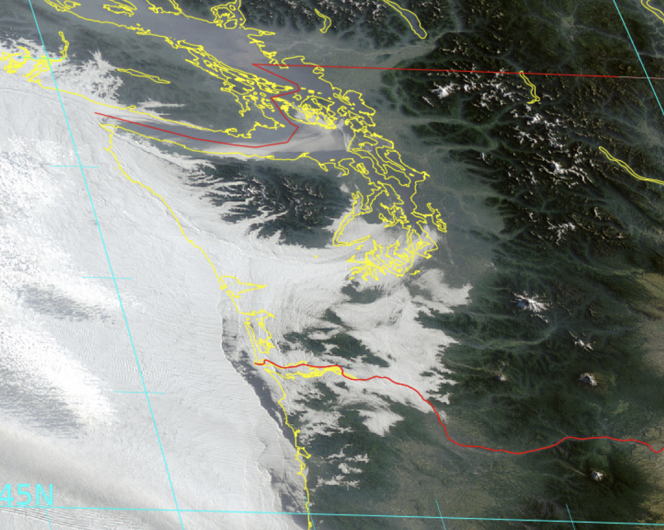
The visible satellite imagery this morning showed that marine clouds not only covered the coast but pushed inland around the Olympics.

The cooling west of the Cascades will be a two-step affair. Last night’s intrusion of cool, marine air was quite shallow. The figure below shows temperature (red lines are temperature in C, wind barbs in black) above SeaTac Airport during the past day. No cooling above 5000 ft. But lots of cooling and a switch to southerly flow below 2500 ft.

What happens in this situation is that where there is sun at the surface, the air starts to mix, with the mixing getting deeper over time. Eventually, we mix down the warm air above and temperatures surge. You will notice that today—- sometime after 10 AM temperatures will warm rapidly into the upper 80s. Sorry.
But the good news is that the marine air will push in again tonight as the thermal trough decidedly moves into eastern Washington…resulting in an additional temperature step down on Wednesday. The ensemble forecasts for Seattle show this clearly (see below). Good sleeping weather ahead!

Environmental Impacts of the Heat Wave
Air quality really took a hit, with increasing amounts of particles and ozone in the atmosphere, something that was evident by the increasing haze I am sure you observed. Here in Seattle, small particles increased to moderate levels (42 micrograms per cubic meter) before plummeting last night. (Figure below from Puget Sound Clean Air Agency)

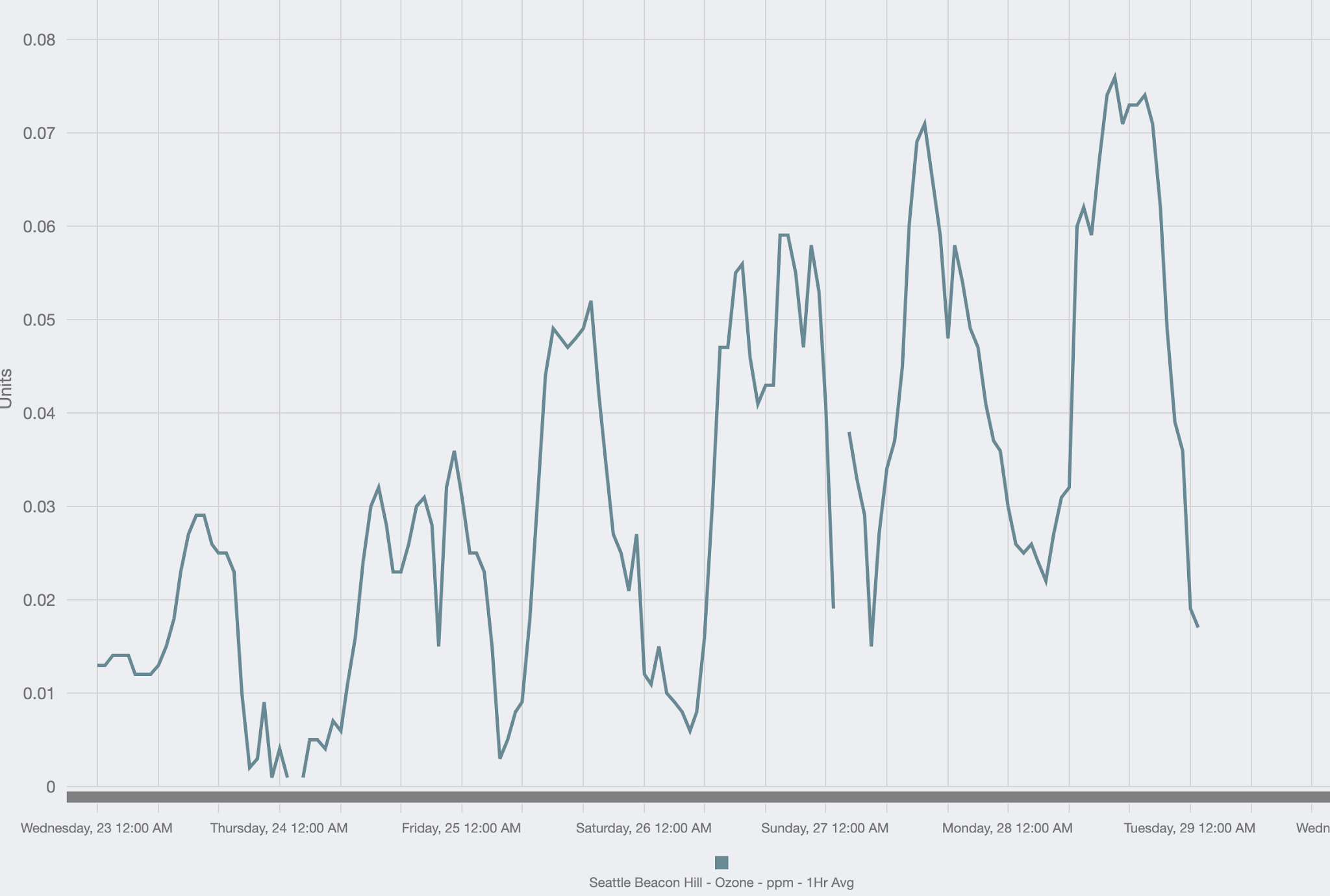
Ozone is another issue and is actually worst not in the cities, but downwind in vegetated areas, such as the foothills of the Cascades. Look at the ozone in Enumclaw, southeast of Seattle. Progressively increased during the last week before dropping rapidly last night.

And there is the plant damage. Yesterday’s searing heat fried many plants, including native species, with leaves turning brown and discolored. How many of you notice wilted and damaged vegetation? The soil was not dry….it was the sheer heat that damaged the plants.


We Can Greatly Reduce Wildfire Risk
There is a lot of concern about regional wildfires. My next blog will talk about how we can radically reduce the risk if our state leaders would act energetically. First, immediately ban all private fireworks statewide, with serious penalties. Second, effectively use weather forecasts for de-energizing powerlines in rural areas where wildfires could break out. I will note that predicted dry conditions can be associated with a reduced lightning threat and lightning starts many of our major fires.
Well, I’m located a bit south of the area you focused on, but can attest to the heat, the damage, and the very welcome marine-layer intrusion.
I’m in Mill City, OR (about 44.75N, at an elevation of about 1000ft, in the Cascade foothills). On Monday, we hit 115.5F on my PWS at around 4:30PM. The cooling began some 10-15 minutes later with a sharp windshift from easterlies (downslope) to westerlies (upslope). The temperature drop was fairly steady, about -10F per hour for three hours, then slowed a bit and continued to cool through the night until we were down to 58F at around 6:00AM on Tuesday.
The westerlies continued through Tuesday and kept the high temperatures just under 90F for the day.
Today was mostly pleasant, with marine layer influence finally burning off in the early afternoon.
Plant damage was pretty severe. Even though soils were reasonably moist, the trees and shrubs could not keep up with the heat, especially for vegetation with direct southern exposure. The new growth on the south side of trees and shrubs was badly scorched, but many appear to have sufficient surviving leaf/needle area to get through this crisis.
My worst problem is my trees that were damaged in September’s wildfire, but which were looking like they would survive. This heat-shock turned much of their new growth from tender green to brittle brown in a matter of hours. Many of the trees that would have barely survived the wildfire are now going to die.
President Biden says it was a lot hotter when he was first elected 180 years ago.
Prime Minister Trudeau replied: “may I quote you on that Mr President”.
We hit 104 Monday on Hood Canal, at low tide no less. Our newly seeded Oyster bags (shellfish farming) were exposed, not sure if they survived. Tuesday showed a large number of dead cockle clams all over. Tuesday night a group of otters moved in and had a wild feast. Wednesday morning we had empty shells everywhere.
I’m pretty sure the otters were pleased with the whole event…
“There is a lot of concern about regional wildfires”
Let it burn, it is natural to do so. There are many plants that have evolved to need fire to reproduce. They are called pyrophytes.
Provided the fires dont impact property, roads etc (ie, clear the land back 100 meters all around, then let them rip. It is nature doing its thing.
LA LA LA- move along, nothing to see here…
From the article: “You want record high temperatures? Come to the Northwest!”
Well, if you weren’t there over the last few days, you missed it.
We get these kinds of temperatures in the southern States all summer long. The Northwest gets something like this that lasts four or five days, and then doesn’t happen again for 100 years.
So, much ado about not very much.
Another way to reduce fire risk: Have cash strapped utilities divert some of the money they have to spend on “green” energy and use it to trim trees away from power lines. It’s called maintenance.
The gullible believes those numbers.
Yes, they do.
Good article! Nice to read a weather story without the hysterics and politics as the lead. It’s been very warm in the Northeast the last few days. When I was a kid they called it a heat wave. Rain today and down in the 60’s now.