Reposted from the Cliff Mass Weather Blog
June 24, 2021
Incredible Temperatures Are Being Predicted and Confidence Is Now High That It Will Occur
There are two possibilities:
- The Northwest will soon experience one of the most incredible weather situations in many decades
- There is a major flaw in virtually all of our weather prediction system
Quite frankly, I am somewhat in shock looking at the raw forecast model predictions or the statistically calibrated versions of their output. The event being predicted is so extreme and so beyond expectation that my natural inclination is to dismiss it.
But I can’t. Multiple modeling systems are essentially doing the same thing. Large ensembles of many forecasts are showing similar solutions from most of the runs.
Let me show you the latest.
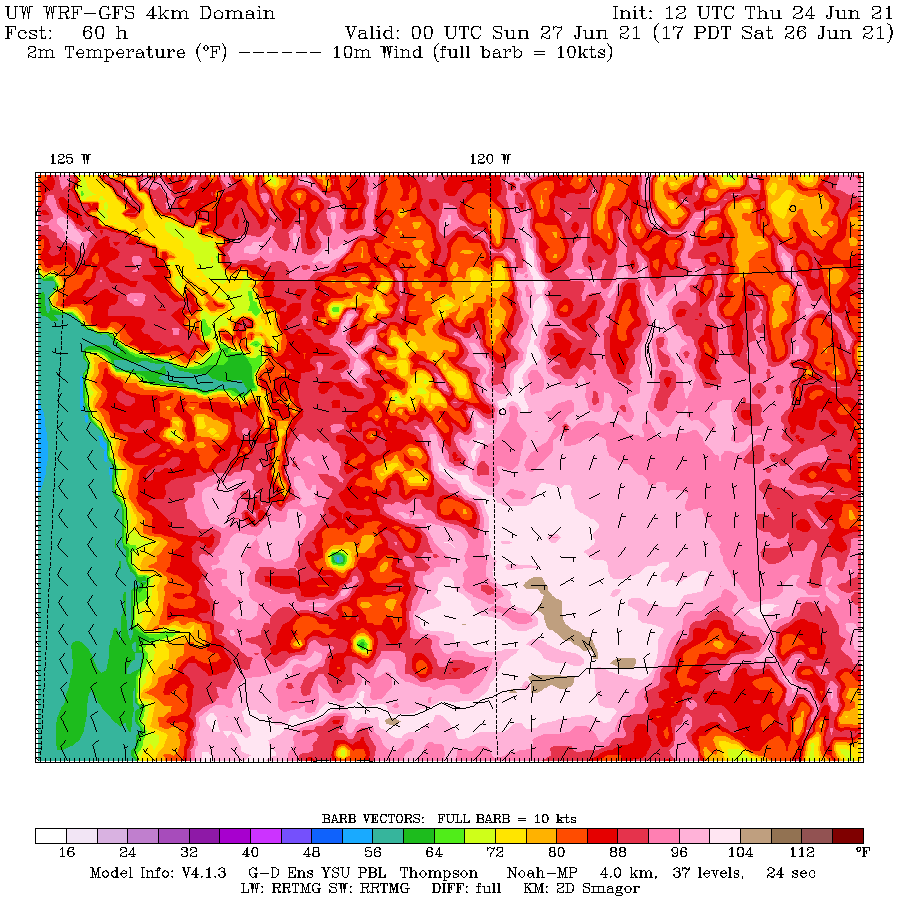
An important issue will be proximity to water and to get that right, high-resolution forecasts are important, so let me start by presenting the latest UW high-resolution simulations. The situation is so extreme that I had the colors altered to better define high temperatures.
Saturday will be the transition day. The temperatures at 5 PM, near the time of the maxima, will exceed 100 F in much of the Columbia Basin and in the northern Willamette Valley (e.g. Portland). 90s will invade the interior of southwest Washington and southern Puget Sound. Warm, but typical of the hottest days of a typical year.

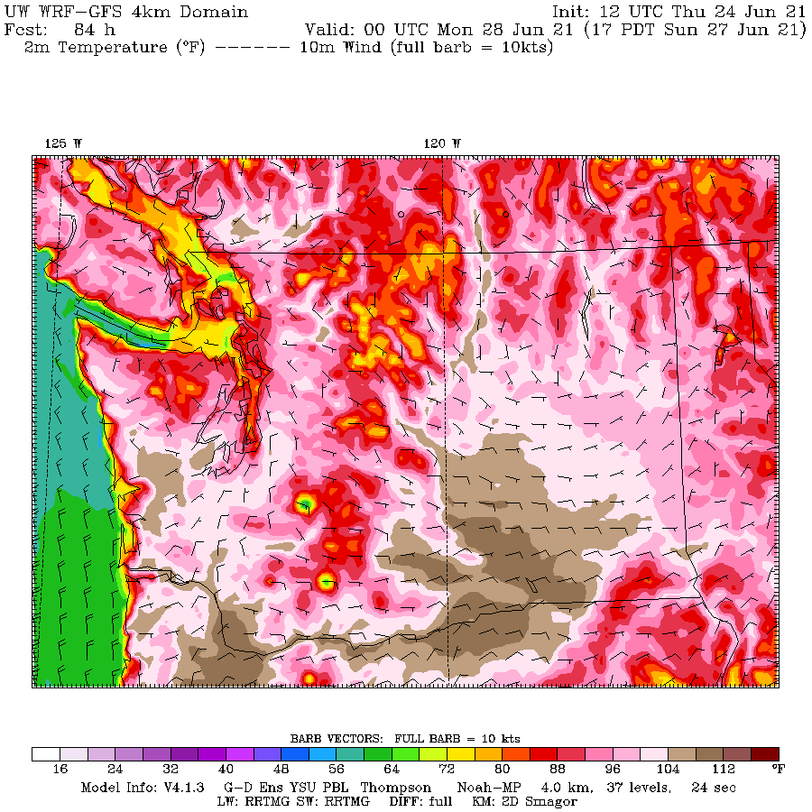
Sunday is something else. Temperatures in the Willamette Valley surge ABOVE 108F, as do the lower elevations of the Columbia Valley. Incredibly, some areas south of the Olympic Mountains get above 104. Can you imagine the temperature gradients near the coast… from the 60s to over 100F in a matter of a few miles? In central Puget Sound, temperatures will rise the 80s near the water to the upper 90s a few miles inland.

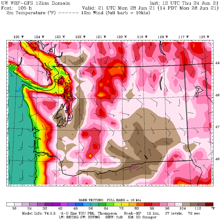
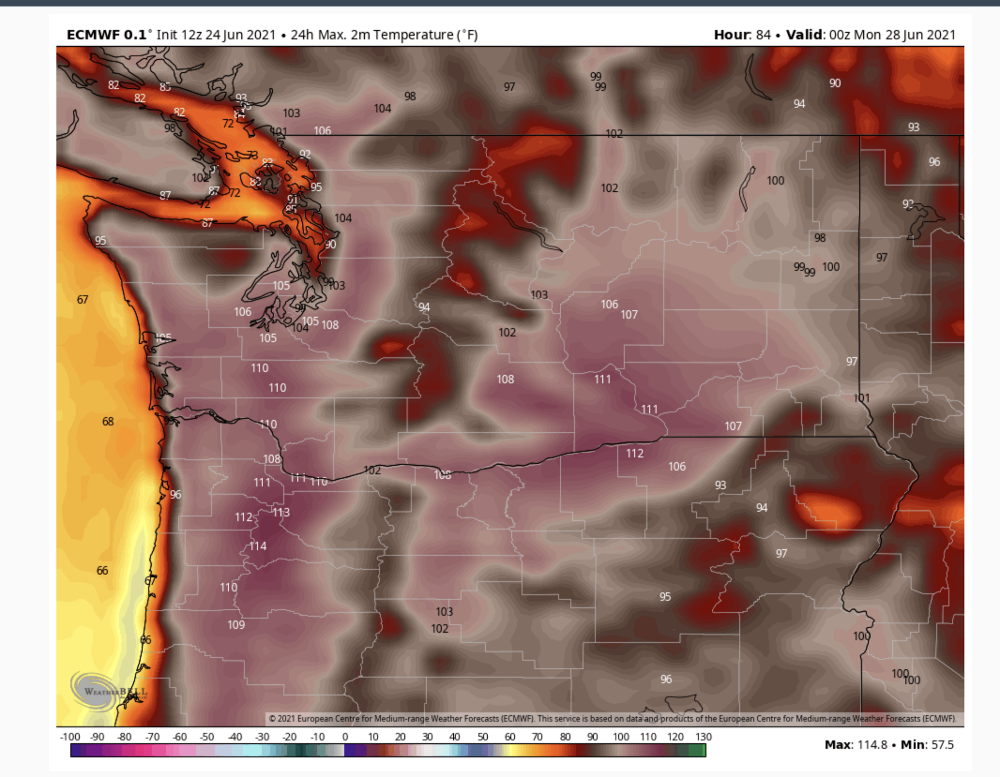
And now Monday at 2 PM. The model resolution is a bit less but the solution is absolutely amazing. Temperatures exceeding 108F will be found in and near the western Cascade foothills, thanks to the warming easterly flow descending the barrier. 104F and higher away from the water around Puget Sound. The Fraser River Valley will also be crazy warm.

If this forecast verifies virtually every major observing location in the western WA and Oregon interior will achieve their all-time temperature record. And several of these locations have observations that go back 70-120 years.
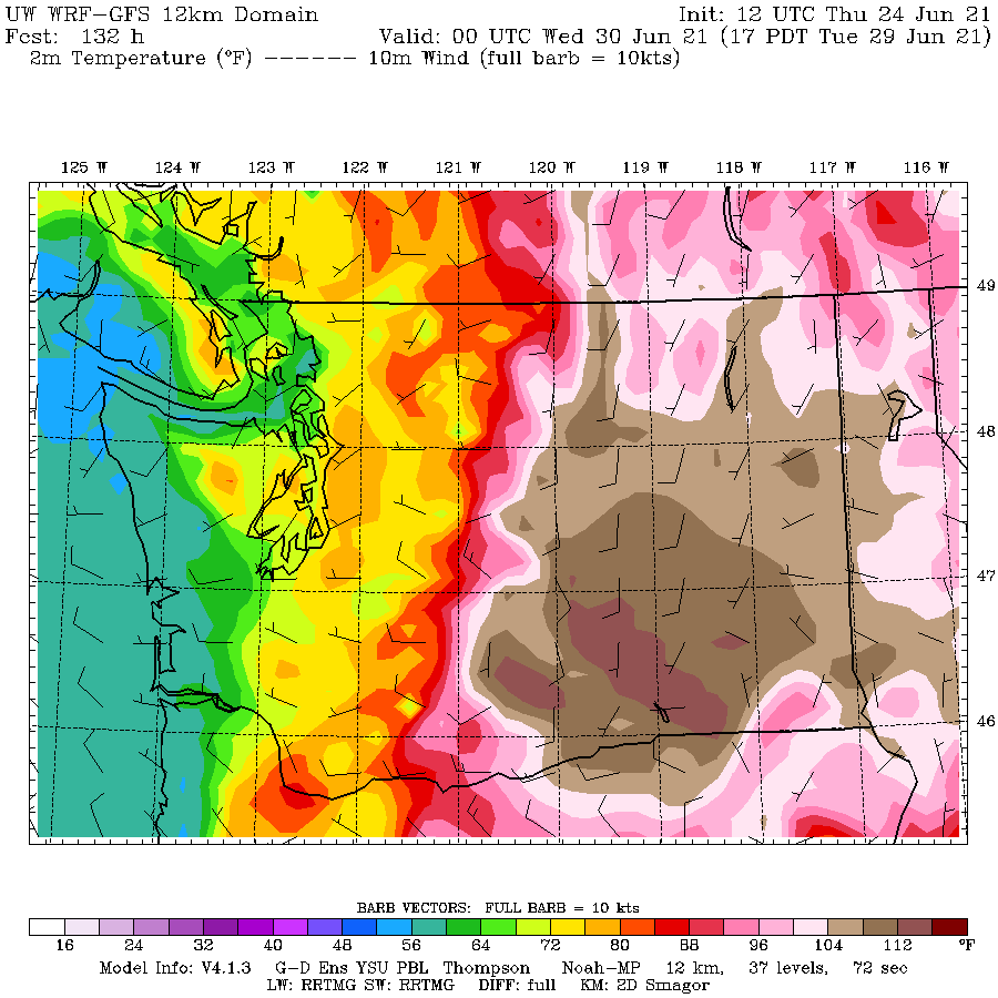
Later Monday, marine air will start to move in along the coast, resulting in Tuesday being a bit cooler west of the Cascade crest (see temperatures at 5 PM Tuesday below). But it will be showtime for the Columbia Basin where the model is going for temperatures OVER 112 F. It is not inconceivable that some locations in eastern Washington will tie or exceed the all-time temperatures record for the state (118F).

The highly skillful European Center model—absolutely different in every way (different data assimilation, different model, different developers)– is going for the same story.
For Sunday, 111F in Portland and 103 in Seattle.

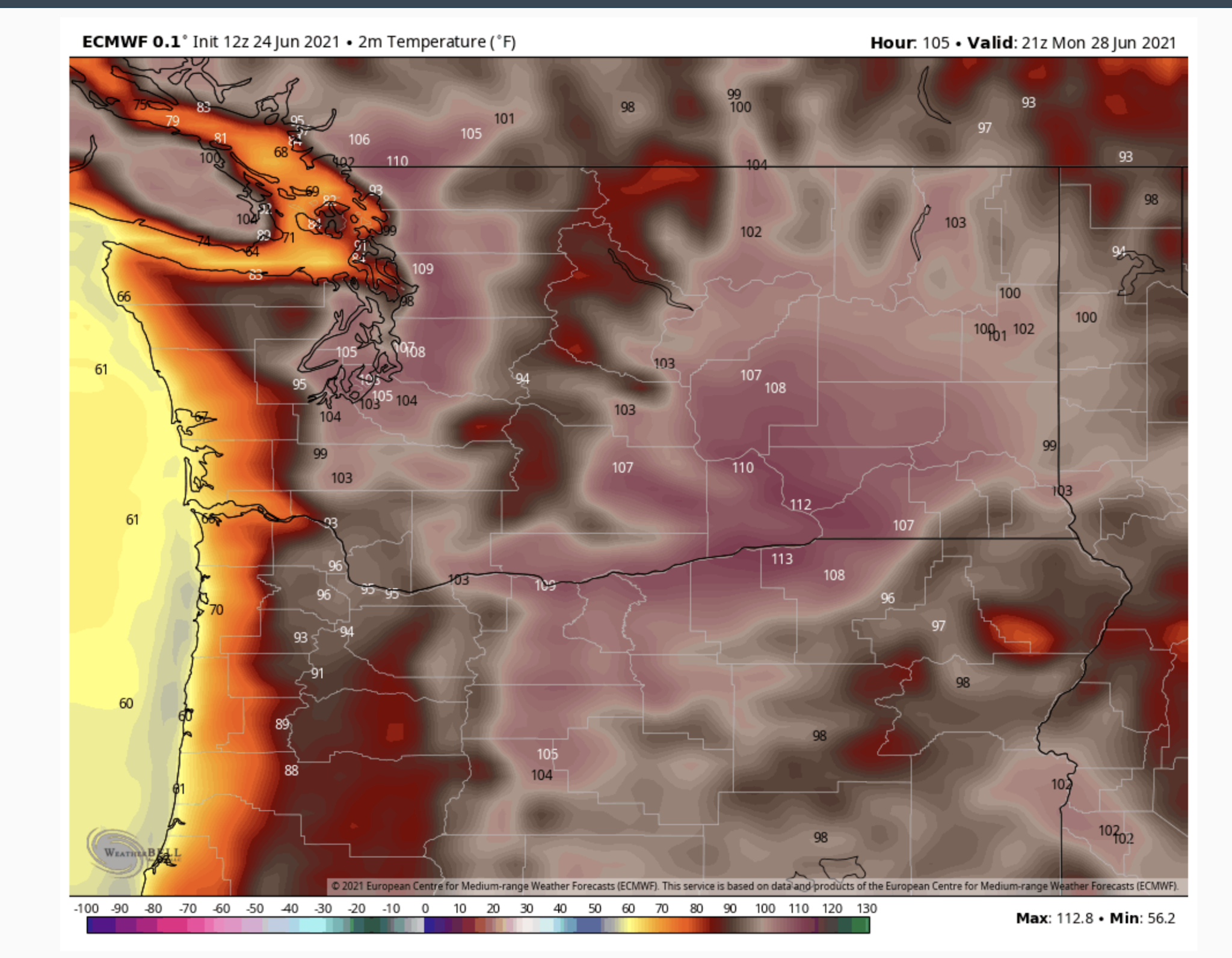
And for Monday at 2 PM an earth-shaking 108F in Seattle. You can see the cooling (orange colors) moving in on Monday afternoon.

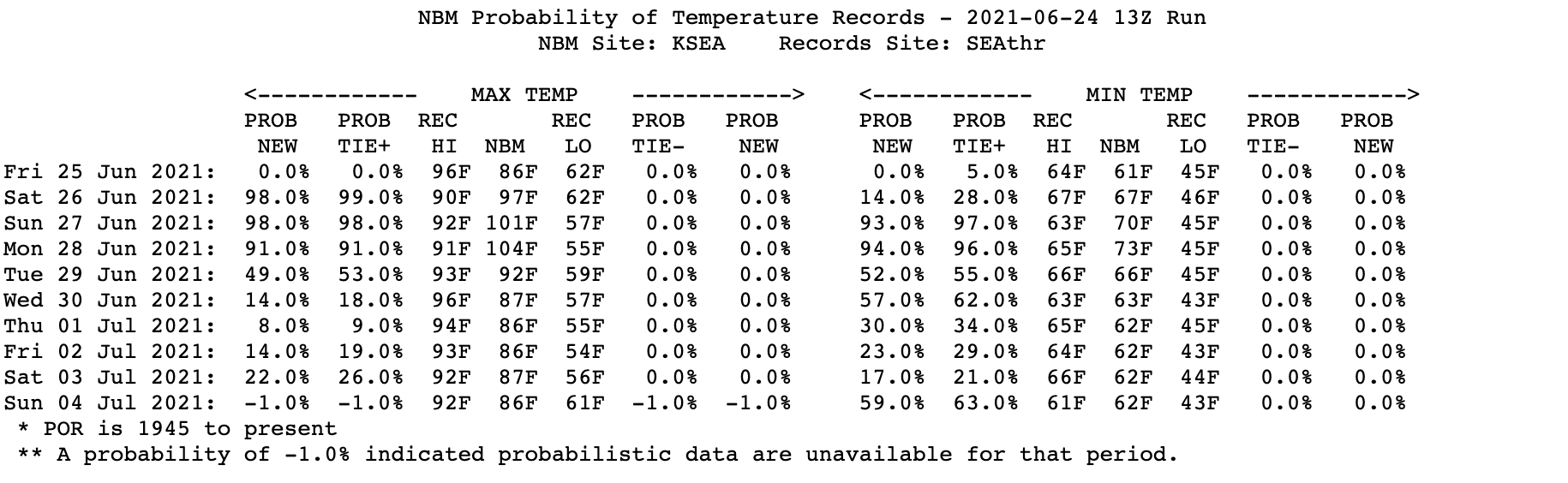
Let me say again: the ensembles of many forecasts show that this solution is the preferred one, with a high probability of verifying. The National Weather Service’s most advanced statistical postprocessing system (the National Blend of Models) that combines many forecasts in an optimal way is now going for 101F on Sunday and 104F on Monday at SeaTac Airport:

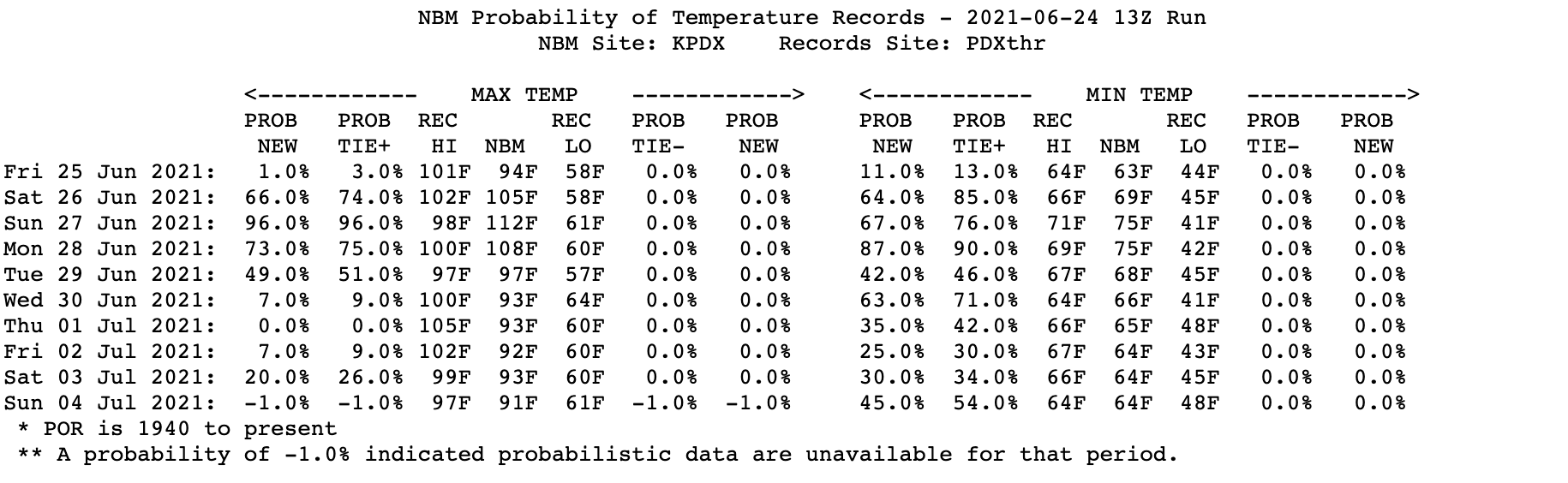
And at Portland: 101F on Friday, 105F on Saturday, 112 on Sunday, and 108F on Monday.

Finally, a number of people have asked about the role of global warming on this event. Is global warming contributing to this heatwave? The answer is certainly yes. Would we have had a record heatwave without global warming. The answer is yes as well.
Our region has warmed by up to 1-2F during the past fifty years and that will enhance the heatwave. Increasing CO2 is probably the biggest contributor to the warming
But consider that the temperature anomalies (differences from normal) during this event will reach 30-35F. The proximate cause of this event is a huge/persistent ridge of high pressure, part of a highly anomalous amplification of the upper-level wave pattern.
There is no evidence that such a wave pattern is anything other than natural variability (I have done research on this issue and published in the peer-reviewed literature on this exact topic).
So without global warming, a location that was 104F would have been 102F. Still a severe heat wave, just slightly less intense.

Let me end with the golden rule of temperature extremes: the bigger the temperature extreme the SMALLER the contribution of global warming. Think about that.
Now PLEASE do not send me emails or leave comments accusing me of helping “deniers” or calling me all kinds of names. I had enough of this from 350Seattle activists and Charles Mudede of the SeattleStranger. I have spent my life working on weather prediction and studying Northwest weather and am trying to communicate the best science, whether or not it fits some folks’ political agendas.
_________________________________________________
The New Edition of My Book: The Weather of the Pacific Northwest Will be Available in August
The book includes new chapters on the meteorology of Northwest wildfires and the weather of British Columbia, and the rest of the book is greatly enhanced. It is available for pre-order on Amazon.

Increasing CO2 is probably the biggest contributor to the (2°F over 50 years) warming
And you know CO2 is the biggest contributor how? Assuming there has been about 1°C (1.8°F) warming since 1970 as you suggest, atmospheric CO2 was 326 ppm in 1970 and is 419 now, increasing by 93 ppm or 28%. It takes a doubling of CO2 to raise temperature 1°C (ie.; 652 ppm) but CO2 has only increased a fraction of that, so how could it be the “biggest contributor” to warming? It’s evident that nature is the biggest contributor. Or the urban heat island effect which biases the temperature upward at so many weather stations.
Usually, Cliff Mass is reasonable, but attributing the majority of the warming to CO2 is speculative. In addiition, claiming that 2 degrees of the heat wave is owing to global warming is flat false. Most of the warming has been in winter and overnight temps, NOT in summer daytime temps.
I live in Portland, Or. I remember the heat wave back 1981 when it hit 107 and was above 100 for five days. Hard to say if global warming is going to make this up coming heat wave even hotter. Only warmed up around 1F in 40 years. Seems more like just a freak weather event.
1981 is forty years ago.
So back then we were also in the meridional phase of the climate cycle.
The intervening 30-year zonal phase of the natural 60-year climate cycle is over for now.
We must get used to this.
I was in hot humid Alabama for the first four days of that heat. I flew back to Portland and stepped off the plane at about 7pm, expecting some nice cool weather, but it felt like I was still in Alabama weather.
Coastal influenced weather in the inland valleys are very nice here in the summers. But sometimes it gets hot, like other parts of the country.
Don’t forget Siberia: one location there just set a day minimum temp equal to previous record high…
Siberia sighs in relief from the most-of-the-year deadly cold.
An anticyclonic stream of dry northerly air flowing through Alberta in western Canada turns to flow to the west in Washington State. The air flow descends towards the Pacific ocean along the line of the Columbia River valley, warming as it loses elevation.
This is a standard Foehn Wind weather event associated with the 30-year long Meridional phase of.the natural 60-year climate cycle.
Nothing to see here, move on.
This is probably similar to the dry, warm Santa Ana winds (from the east) that sometimes blow in California when a big anticyclone (high-pressure area) sets up over Oregon or Idaho. The fact that this is occurring shortly after the summer solstice means that the sun’s heating power is near its maximum, with no clouds to block it out, and the cooling “marine layer” is blown farther out to sea.
This can sometimes occur in other areas with ocean to the west, and a large land area to the east, which are accustomed to winds blowing from the west off the ocean, which normally results in relatively cool summers and mild winters. About 20 years ago, along the west coast of France (where summer temperatures rarely exceed 85 F), a large anticyclone stalled over England and Scandinavia for over a week in July, sending strong easterly winds across northern France with cloudless skies, and temperatures soared above 35 C (95 F) for several consecutive days.
If such an event occurs in winter, it usually brings unusually cold weather to northern France, since the warming effect of the Gulf Stream is neutralized, and long, clear nights enable heat to be radiated into space.
The CO2 concentration in the air has very little effect on the weather, if any. We can all read “long-term averages” (over 30 years or more) for the high and low temperature for a given date, but there are lots of large deviations in both directions around these averages, most of which depend on the relative positions of high- and low-pressure areas and the jet stream relative to the location in question, and the wind direction and speed (whether it’s blowing off a large body of water, or off land or mountains).
Okay, well, nothing personal but I think I will continue to peruse the Old Farmer’s Almanac and the Farmers Almanac, and the National Weather Service’s forecasts, which are pretty close to the mark.
While I”m perpetually puzzled about the reaction to having a little hot summer weather, I will add here, as I have said before, that I prefer a nice, cozy warm planet over a frozen snowball.
And here in the Mid West we forecast to have rain for the next seven days. The Surface Analysis for CONUS has ten Lows from the Atlantic to the Pacific, but only two Highs.
Yes, we are and it started on Sunday evening where I am. I am happy to see it continue to drip out of the sky, kind of like watching a pitcher of iced tea sweat in the summer humidity. We do need it, rather badly, and now my lawn no longer looks like the middle of September. I’d better get a small pack of grass seed for the few bare spots.
Sir, I may not agree with the predictions, but you have presented the information in a concise and informative manner
My son would be happy for a little bit of that heat. He’s got swim practice in an hour (9:15), and it’s currently 63 here in Charlotte, NC. The high is only 82, same as the last two days.
I grew up in the South. These kinds of temps are “normal,” but below what you expect for the end of June.
But all anyone talks about is when it gets too hot. Then it’s all because of our cars.
So one (up to two) degrees warmer – in that region – than a time that caused climatistas to warn of an ice age. I sense 1 -2 degrees H(ype).
Somewhere on Antarctica next week it could easily be 200 degrees(f) colder than it will be in the Pacific Northwest. 200 degrees is more than the differential between freezing water and boiling water. It’s quite a remarkable planet we live on..
Antifa will howl at the Strawberry moon over this…
Since most of the excess heat is the result of the compression of the air, it follows that as the air decompresses, it will become colder than “normal”.
Where is this cooling effect showing up in these models?
“The proximate cause of this event is a huge/persistent ridge of high pressure, part of a highly anomalous amplification of the upper-level wave pattern.
There is no evidence that such a wave pattern is anything other than natural variability (I have done research on this issue and published in the peer-reviewed literature on this exact topic).”
Ok, what are the contributing causes of these events? Is this similar to the blocking high over Siberia that got everyone excited recently? Are these patterns more likely as the jet stream meanders?
“There is no evidence that such a wave pattern is anything other than natural variability”
That’s right. Lots of things are being attributed to jet stream behavior, but, as you say, there is no evidence it is anything other than natural variability (Mother Nature). Although there are some interesting conjectures.
I was a weather forecaster in the pre-PC days before we had access to multiple models with the ability to compare them. I had only 2 models NOGAPS (Navy) and GFS. Today the forecasters have 10 models and the ability to compare them all. When I went through forecasting school we were told to never forecast all-time record temperatures (understandable since we had so little access to different models). Now there are 7 out of 10 models with the best of them (the ECMWF) going for temperatures above 110F for PDX and even slightly higher on Monday. But it looks like all the forecasters in Portland are stuck in the “never forecast higher than the all-time record” mode even if it means you throw out all the guidance It appears to me that is what they are doing-they are only going for 1 deg F over the record. (Cowards). I think the forecasters are going to be making all kinds of excuses come Monday morning.
I think they underestimate the amount of negative latent heat that is still present in this area so early in the season. First of all the land is still quite moist after the rainy season not having ended too long ago. Also looking up the window towards the mountains you can still see quite some significant snow-pack and that not only on Mount Rainier and Baker, but on most of the ridges in the Cascades and the Olympics. The melting and evaporation can absorb a lot of the heat and then the evaporation can condensate in the high atmosphere that can increase the albedo and partially block the insolation.
I’ve been following this for a bit. There is no way any of this is actually ‘reality’.
https://earth.nullschool.net/#current/wind/surface/level/overlay=temp/orthographic=-119.05,37.68,417 (you can change parameters on the lower left)
Cliff is one of the best, objective and extraordinarily knowledgeable meteorologists in the business. In an elite class.
In covering it myself, I went to a source from the last 2 decades, the EPA heat wave page/graphic and found that they wiped out the significance of the widespread/long lived 1930’s, Dust Bowl heat waves.
It’s like the sequel to Michael Mann’s hockey stick(that rewrote global climate history and wiped out the Medieval WARM period/optimum) ……this is some mega corrupt data altering and they are BUSTED!
See the compelling evidence that the corrupt United States EPA, in April 2021, rewrote US heat wave history to wipe out the true significance of the long lived, widespread heat waves during the Dust Bowl decade………1930’s……….to make global warming/climate change appear to be MUCH worse than it really is today.
https://www.marketforum.com/forum/topic/71468/#71521
Proof that record highs are NOT increasing:
https://www.marketforum.com/forum/topic/71468/#71518
Half of the record highs that still stand today, were set in the 1930’s:
https://www.marketforum.com/forum/topic/71468/#71520
Provided the analysis for how the EPA accomplished their wiping out the true significance of the record smashing hottest decade ever……the 1930’s:
https://www.marketforum.com/forum/topic/71468/#71612
What a beautiful day in the PNW! Mt Rainier is 120 miles away and gorgeous.
The heat advisory is valid. People in Seattle are clueless. Normally their bodies are cooled by drizzle. They go a little crazy when it is nice and over do it.
Many years ago we were boat camping near Wallula Gap with a predicted high 116 degrees F. I knew I had to get my wife out of the heat and booked a hotel room. Instead I dropped her off at the ER and she had stents put in.
Association is not causation! I listened as the doctor questioned her. She had been feeling bad for a month. When I asked her 30 minutes before she said she was ‘fine’.
Back home from vacation, a neighbor called us to come over and watch his elderly mother while an ambulance took him to the ER. Based on test results there is different treatment for indigestion.
So enjoy beautiful days but do not stupidity shorten the number of those days you have.
From the article: “Our region has warmed by up to 1-2F during the past fifty years and that will enhance the heatwave.”
So you are starting your determination in the 1970’s, which is the only way you can claim “our region has warmed by up to 1-2F during the past fifty years”.
If you start in the 1930’s, your region, and the entire United States and the North American continent are actually cooler than in the 1930’s, so we are in a temperature downtrend, not an uptrend. So how can it be claimed that we are warming, and this warming is implied to be unprecedented, when we are in a temperature downtrend?
From the article: “Increasing CO2 is probably the biggest contributor to the warming”
An unsubstantiated assertion.
For those that live in the South, and have humidity, 100F heat index is common and expected. We also have years where the air temp gets to 100F and then the heat index on top. So summer can get hot, but luckily we live in a time where a room ac can be had for under $300. Ice cubes, refrigeration, air conditioning….this is life in the South. Quit freaking, these are not the End Times. Maybe even embrace it; put on the swim trunks, turn on the sprinklers, and frolic like a child!
I live near Seattle…there are no room air conditioners for sale within 100 miles.
I have things called windows which I normally open at night and close during the day.
It’s 5 AM and the windows have been opened all night…the temp in the house is down to 76 from a high of 84 at sunset . Yesterday at this time the temp in the house was 66.
Our homes don’t come with things call ‘heat pumps’…they come with ‘furnaces’. Rich people in multi-million dollars homes don’t have central air.
There have only been 3 100+ degree days in history in Seattle.
Anyone who thinks the grid is going to survive temps 12 degrees above the previous record high temp is delusional. The current forecast for Monday is 115 degrees.
If the 115 degree forecast comes to pass there will be plenty of dead bodies.
I understand that predicament. I remember the problem in Europe when a heat wave hit and the folks that suffered were in the city, with no ac, and no one to come and check on them.
If there were cheap abundant energy, reliable power grid and simple small one room air conditioners, there would be no problem.
If the power fails, hopefully there will be a central location with generator to provide for the people.
Weather happens. Recod=rd high temoeratures happen. Always have always will. It’s a characteristic of chaotic systems to have the occasional highest (and lowest) values even if th previous measurements go back 50, 100o, 200, 1000 years, there will be records set.
And regarding:
I live inland in Southern California, 20 miles from the coast and we frequently have 100+ degree days when it’s in the 60’s or 70’s on the coast.
Unusual cold end of june temperatures in France with rain and storms.