Guest Post by Willis Eschenbach
Well, for my sins I’ve been working on a paper with the hope of getting it published in a journal. Now that it’s nearly done, I realized that I have the worlds’ best peer-reviewers available on WUWT. So before seeing if I can get this published, I thought I’d take advantage of you good folks for some “peer preview”, to point out to me any problems you might see with the title, format, style, data, conclusions, or any other part of the following paper. All of the graphics are in grayscale because that’s what the journals want.
Many thanks for any and all contributions.
w.
The Emergent Thermostat
Abstract
The current paradigm of climate science is that the long-term change in global temperature is given by a constant called “climate sensitivity” times the change in downwelling radiation, called “radiative forcing”. However, despite over forty years of investigation, the uncertainty of the value of climate sensitivity has only increased.1 This lack of any progress in determining the most central value in the current paradigm strongly suggests that the paradigm itself is incorrect, that it is not an accurate description of reality. Here I propose a different climate paradigm, which is that a variety of emergent climate phenomena act in concert to keep the surface temperature within tight limits. This explains the unusual thermal stability of the climate system.
Overview
Several authors have analyzed the climate system as a heat engine. Here is Reis and Bejan’s description
The earth with its solar heat input, heat rejection, and wheels of atmo- spheric and oceanic circulation, is a heat engine without shaft: its maximized (but not ideal) mechanical power output cannot be delivered to an extraterrestrial system. Instead, the earth engine is destined to dissipate through air and water friction and other irreversibilities (e.g., heat leaks across finite ∆T) all the mechanical power that it produces. It does so by ‘‘spinning in its brake’’ the fastest that it can (hence the winds and the ocean currents, which proceed along easiest routes).2
When viewed as a heat engine, one of the most unusual and generally unremarked aspects is its astounding stability. Over the 20th Century, the global average surface temperature varied by less than one kelvin. This is a variation of ± 0.2%. Given that the system rejects a variable amount of incoming energy, with the variations mostly controlled by nothing more solid than clouds, this is a most surprising degree of stability.
This in turn strongly argues for some global thermoregulatory mechanism. The stability cannot be from simple thermal inertia, because the hemispheric land temperatures vary by ~ 20K over the year, and hemispheric sea temperatures vary by ~ 5K.
Emergence
There is no generally accepted definition of emergence. In 1874 Lewes proposed the following definition: “Emergence: Theory according to which the combination of entities of a given level gives rise to a higher level entity whose properties are entirely new”.3
For the purposes of this article, I will define emergent climate phenomena functionally and by example.
Emergent climate phenomena arise spontaneously, often upon passing some thermal or other threshold. Consider the daily development of the tropical cumulus cloud field. Upon passing a temperature threshold, out of a clear sky hundreds of individual cumulus clouds can appear in a short time.
They have a time of emergence and a limited lifespan. Dust devils form spontaneously at a certain moment, persist for a while, and then dissipate and disappear.
They form a separate whole, distinct from the surroundings. Tropical thunderstorms are surrounded by clear air.
They are often mobile and move in unpredictable ways. As a result, tropical cyclones have “prediction cones” for where they might possibly go next, rather than being accurately predictable.
They are often associated with phase changes in the relevant fluids. Convective cloud emergence involves a phase change of water.
Once in existence, they can persist below the threshold necessary for their emergence. Rayleigh-Benard circulation requires a certain temperature difference to emerge, but once in existence, the circulation can persist at a smaller temperature difference.
They are flow systems far from equilibrium. As such, in accordance with the Constructal Law4, they must evolve and mutate to survive.
They are not naively predictable, as they have entirely different properties than the substrate from which they emerge. If you lived somewhere that there were never clouds, you likely would not predict that a giant white object might suddenly appear hundreds of meters above your head.
Examples of natural emergent phenomena with which we are familiar include the behavior of flocks of birds, vortices of all kinds, termite mounds, consciousness, and indeed, life itself. Familiar emergent climate phenomena include thunderstorms, tornadoes, Rayleigh-Bénard circulation of the atmosphere and ocean, clouds, cyclones, El Ninos, and dust devils.
A Simple Example
To explain how emergent phenomena thermoregulate the earth’s surface temperature, consider the lowly “dust devil”. As the sun heats a field in the summer, the change in temperature is some fairly linear function of the “forcing”, the downwelling solar radiation. This is in accord with the current paradigm. But when the hottest part of the field reaches a certain temperature with respect to the overlying atmospheric temperature, out of the clear sky a dust devil emerges. This cools the surface in several ways. First, it moves warm surface air upwards into the lower troposphere. Second, it increases sensible heat transfer, which is a roughly linear function of the air velocity over the surface. Third, it increases evaporation, which again is a roughly linear function of the surface air velocity.
At this point, the current paradigm that the change in temperature is a linear function of the change in forcing has broken down entirely. As the sunshine further irradiates the surface, instead of getting more temperature we get more dust devils. This puts a cap on the surface temperature. Note that this cap is not a function of forcing. The threshold is temperature-based, not forcing-based. As a result, it will not be affected by things like changing amounts of sunshine or variations in greenhouse gases.
A Complete Example
The heavy lifting of the thermoregulatory system, however, is not done by dust devils. It is achieved through variations in the timing and strength of the daily emergence of tropical cumulus fields and the ensuing tropical thunderstorms, particularly over the ocean. This involves the interaction of several different emergent phenomena
Here is the evolution of the day and night in the tropical ocean. The tropical ocean is where the majority of the sun’s energy enters the huge heat engine we call the climate. As a result, it is also where the major thermostatic mechanisms are located.

Figure 1. Daily emergent phenomena of the tropical ocean.
As seen in Panel “Early Morning”, at dawn, the atmosphere is stratified, with the coolest air nearest the surface. The nocturnal emergent Rayleigh-Bénard overturning of the ocean is coming to an end. The sun is free to heat the ocean. The air near the surface eddies randomly.
As the sun continues to heat the ocean, around ten or eleven o’clock in the morning a new circulation pattern emerges to replace the random atmospheric eddying. As soon as a critical temperature threshold is passed, local Rayleigh-Bénard-type circulation cells emerge everywhere. This is the first emergent transition, from random circulation to Rayleigh-Bénard circulation. These cells transport both heat and water vapor upwards.
By late morning, the Rayleigh-Bénard circulation is typically strong enough to raise the water vapor to the local lifting condensation level (LCL). At that altitude, the water vapor condenses into clouds as shown in Panel “Late Morning”.
This area-wide shift to an organized circulation pattern is not a change in feedback, nor is it related to forcing. It is a self-organized emergent phenomenon. It is threshold-based, meaning that it emerges spontaneously when a certain threshold is passed. In the wet tropics there’s plenty of water vapor, so the major variable in the threshold is the temperature. In addition, note that there are actually two distinct emergent phenomena in Panel 2—the Rayleigh-Bénard circulation which emerges prior to the cumulus formation, and which is enhanced and strengthened by the totally separate emergence of the clouds. We now have two changes of state involved as well, with evaporation from the surface and condensation and re-evaporation at altitude.
Under this new late-morning cumulus circulation regime, much less surface warming goes on. Part of the sunlight is reflected back to space, so less energy makes it into the system to begin with. Then the increasing surface wind due to the cumulus-based circulation pattern increases the evaporation, reducing the surface warming even more by moving latent heat up to the lifting condensation level.
The crucial issues here are the timing and strength of the emergence. If the ocean is a bit warmer, the new circulation regime starts earlier in the morning and it cuts down the total daily warming. On the other hand, if the ocean is cooler than usual, clear morning skies last later into the day, allowing increased warming. The system temperature is thus regulated both from overheating and excessive cooling by the time of onset of the regime change.
Consider the idea of “climate sensitivity” in this system, which is the sensitivity of surface temperature to forcing. The solar forcing is constantly increasing as the sun rises higher in the sky. In the morning before the onset of cumulus circulation, the sun comes through the clear atmosphere and rapidly warms the surface. So the thermal response is large, and the climate sensitivity is high.
After the onset of the cumulus regime, however, much of the sunlight is reflected back to space. Less sunlight remains to warm the ocean. In addition to reduced sunlight, there is increased evaporative cooling. Compared to the morning, the climate sensitivity is much lower.
So here we have two situations with very different climate sensitivities. In the early morning, climate sensitivity is high, and the temperature rises quickly with the increasing solar insolation. In the late morning, a regime change occurs to a situation with much lower climate sensitivity. Adding extra solar energy doesn’t raise the temperature anywhere near as fast as it did earlier.
At some point in the afternoon, there is a good chance that the cumulus circulation pattern is not enough to stop the continued surface temperature increase. If the temperature exceeds a certain higher threshold, as shown in Panel “Late Afternoon”, another complete regime shift takes place. The regime shift involves the spontaneous emergence of independently mobile heat engines called thunderstorms.
Thunderstorms are dual-fuel heat engines. They run on low-density air. That air rises and condenses out the moisture. The condensation releases heat that re-warms the air, which rises deep into the troposphere.
There are two ways the thunderstorms get low-density air. One is to heat the air. This is how a thunderstorm gets started, as a solar-driven phenomenon emerging from strong cumulus clouds. The sun plus GHG radiation combine to heat the surface, which then warms the air. The low-density air rises. When that circulation gets strong enough, thunderstorms start to form. Once the thunderstorm is started, the second fuel is added — water vapor. The more water vapor there is in the air, the lighter it becomes. The thunderstorm generates strong winds around its base. Evaporation is proportional to wind speed, so this greatly increases the local evaporation. This makes the air lighter and makes the air rise faster, which makes the thunderstorm stronger, which in turn increases the wind speed around the thunderstorm base. A thunderstorm is a regenerative system, much like a fire where part of the energy is used to power a bellows to make the fire burn even hotter. Once it is started, it is much harder to stop. This gives thunderstorms a unique ability that is not represented in any of the climate models. A thunderstorm is capable of driving the surface temperature well below the initiation temperature that was needed to get the thunderstorm started. It can run on into the evening, and often well into the night, on its combination of thermal and evaporation energy sources.
Thunderstorms function as heat pipes that transport warm air rapidly from the surface to the lifting condensation level where the moisture turns into clouds and rain, and from there to the upper atmosphere without interacting with the intervening greenhouse gases. The air and the energy it contains are moved to the upper troposphere hidden inside the cloud-shrouded thunderstorm tower, without being absorbed or hindered by GHGs on the way. Thunderstorms also cool the surface in a host of other ways, utilizing a combination of a standard refrigeration cycle with water as the working fluid, plus cold water returned from above, clear surrounding air allowing greater upwelling surface radiation, wind-driven evaporation, spray increasing evaporation area, albedo changes, and cold downwelling entrained air.
As with the onset of the cumulus circulation, the onset of thunderstorms occurs earlier on days when it is warmer, and it occurs later (and sometimes not at all) on days that are cooler than usual. Again, there is no way to assign an average climate sensitivity. The warmer it gets, the less each additional watt per meter warms the surface.
Once the sun sets, first the cumulus and then the thunderstorms decay and dissipate. In Panel 4, a final and again different regime emerges. The main feature of this regime is that during this time, the ocean radiates the general amount of energy that was absorbed during all of the other parts of the day.
During the nighttime, the surface is still receiving energy from the greenhouse gases. This has the effect of delaying the onset of oceanic overturning, and of reducing the rate of cooling. Note that the oceanic overturning is once again the emergent Rayleigh-Bénard circulation. Because there are fewer clouds, the ocean can radiate to space more freely. In addition, the overturning of the ocean constantly brings new water to the surface to radiate and cool. This increases the heat transfer across the interface. As with the previous thresholds, the timing of this final transition is temperature-dependent. Once a critical threshold is passed, oceanic overturning emerges. Stratification is replaced by circulation, bringing new water to radiate, cool, and sink. In this way, heat is removed, not just from the surface as during the day, but from the entire body of the upper layer of the ocean.
Predictions
A theory is only as good as its predictions. From the above theoretical considerations we can predict the following:
Prediction 1. In warm areas of the ocean, clouds will act to cool the surface, and in cold areas they will act to warm the surface. This will be most pronounced above a temperature threshold at the warmest temperatures.
Evidence validating the first prediction.

Figure 2. Scatterplot, sea surface temperature (SST) versus surface cloud radiative effect. The more negative the data the greater the cooling.
As predicted, the clouds warm the surface when it is cold and cool it when it is warm, with the effect very pronounced above about 26°C – 27°C.
Prediction 2. In the tropical ocean, again above a certain temperature threshold, thunderstorms will increase very rapidly with increasing temperature.
Evidence validating the second prediction.
Since there is always plenty of water over the tropical ocean, and plenty of sunshine to drive them, thermally driven tropical thunderstorms will be a function of little more than temperature.

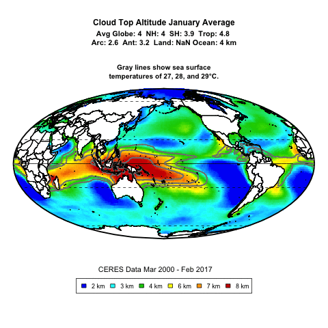
Figure 3. Cloud top altitude as a proxy for deep convective thunderstorms versus sea surface temperature.
As with clouds in general, there is a clear temperature threshold at about 26°C – 27°C, with a nearly vertical increase in thunderstorms above that threshold. This puts a very strong cap on increasing temperatures.
Prediction 3. Transient decreases in solar forcing such as those from eruptions will be counteracted by increased sunshine from tropical cumulus forming later in the day and less frequently. This means that after an initial decrease, incoming solar will go above the pre-eruption baseline until the status quo ante is re-established.
Evidence validating the third prediction.
Regarding the third prediction, my theory solves the following Pinatubo puzzle from Soden et al.5
“Beginning in 1994, additional anomalies in the satellite-observations of top-of-atmosphere absorbed solar radiation become evident, which are unrelated to the Mount Pinatubo eruption and therefore not reproduced in the model simulations. These anomalies are believed to stem from decadal-scale changes in the tropical circulation over the mid to late 1990’s [see J. Chenet al., Science 295, 838 (2002); and B.A. Wielicki et al., Science 295, 841 (2002], but their veracity remains the subject of debate. If real, their absence in the model simulations implies that discrepancies between the observed and model-simulated temperature anomalies, delayed 1 to 2 years by the climate system’s thermal inertia, may occur by the mid-1990s.”

Figure 4. Soden Figure 1, with original caption
However, this is a predictable result of the emergent thermostat theory. Here is the change in lower atmospheric temperature along with the ERBS data from Soden:

Figure 5. ERBE absorbed solar energy (top panel in Figure 4) and UAH lower tropospheric temperature (TLT). Both datasets include a lowess smoothing.
As predicted by the theory, the absorbed solar energy goes above the baseline until the lower troposphere temperature returns to its pre-eruption value. At that point, the increased intake of solar energy ceases and the system is back in its steady-state condition.
Prediction 4. The “climate sensitivity”, far from being a constant, will be found to be a function of temperature.
Evidence validating the fourth prediction.
Figure 6 below shows the 1° latitude by 1° longitude gridcell by gridcell relationship between net downwelling radiation at the surface and the surface temperature.

Figure 6. Scatterplot, CERES net downwelling surface radiation (net shortwave plus longwave) versus Berkeley Earth global surface temperature. The slope of the lowess smooth at any point is the “climate sensitivity” at that temperature, in °C per watt per square metre (W/M2)
The tight correlation between the surface temperature and the downwelling radiation confirms that this is a valid long-term relationship. This is especially true given that the two variables considered are from entirely different and unrelated datasets.
Note that the “climate sensitivity” is indeed a function of temperature, and that the climate sensitivity goes negative at the highest temperatures. It is also worth noting that almost nowhere on the planet does the long-term average temperature go above 30°C. This is further evidence of the existence of strong thermoregulatory mechanisms putting an effective cap on how hot the surface gets on average.
Prediction 5. In some areas, rather than the temperature being controlled by the downwelling surface radiation, the surface radiation will be found to be controlled by the temperature.
Evidence validating the fifth prediction.
Figure 7 below shows the correlation between net downwelling surface radiation (net shortwave plus longwave) and surface temperature. As expected, over most of the land masses the correlation is positive—as the downwelling radiation increases, so does the surface temperature.

Figure 7. Correlation between monthly surface temperatures and monthly surface downwelling radiation. Seasonal variations have been removed from both datasets.
However, over large areas of the tropical ocean, the temperature and downwelling surface radiation are negatively correlated. Since decreasing downwelling radiation cannot increase the surface temperature, the only possible conclusion is that in these areas, the increasing temperature modifies the number and nature of the overlying clouds in such a way to decrease the downwelling radiation.
CONCLUSIONS
1) The current climate paradigm, which is that in the long run, changes in global surface temperature are a simple linear function of changes in forcing (downwelling radiation), is incorrect. This is indicated by the inability of researchers to narrow the uncertainty of the central value of the paradigm, “climate sensitivity”, despite forty years of investigations, millions of dollars, billions of computer cycles, and millions of work-hours being thrown at the problem. It is also demonstrated by the graphs above which show that far from being a constant, the “climate sensitivity” is a function of temperature.
2) A most curious aspect of the climate system is its astounding stability. Despite being supported at tens of degrees warmer than the moon by nothing more stable than evanescent clouds, despite volcanic eruptions, despite changes in CO2 and other GHG forcings, despite great variations in aerosols and black carbon, over the 20th Century the temperature varied by only ±0.2%.
3) This amazing stability implies and indeed requires the existence of a very strong thermoregulation system.
4) My theory is that the thermoregulation is provided by a host of interacting emergent phenomena. These include Rayleigh-Benard circulation of the ocean and the atmosphere; dust devils; tropical thermally-driven cumulus cloud fields; thunderstorms; squall lines; cyclones; tornadoes; the La Nina pump moving tropical warm water to the poles and exposing cool underlying water; and the great changes in ocean circulation involved with the Pacific Decadal Oscillation, the North Atlantic Oscillation, and other oceanic cycles.
5) This implies that temperatures are unlikely to vary greatly from their current state because of variations in CO2, volcanoes, or other changing forcings. The thresholds for the various phenomena are temperature-based, not forcing-based. So variations in forcing will not affect them much. However, it also opens up a new question—what causes slow thermal drift in thermoregulated systems?
REFERENCES
1 Knutti, R., Rugenstein, M. & Hegerl, G. Beyond equilibrium climate sensitivity. Nature Geosci 10, 727–736 (2017). https://doi.org/10.1038/ngeo3017
2 Lewes, G. H. (1874) in Emergence, Dictionnaire de la langue philosophique, Foulquié.
3 Reis, A. H., Bejan, A, Constructal theory of global circulation and climate, International Journal of Heat and Mass Transfer, Volume 49, Issues 11–12, 2006, Pages 1857-1875, https://doi.org/10.1016
4 Bejan, A, Reis, A. Heitor, Thermodynamic optimization of global circulation and climate, International Journal of Energy Research, Vol. 29, Is. 4, https://doi.org/10.1002/er.1058
5 Brian J. Soden et al., Global Cooling After the Eruption of Mount Pinatubo: A Test of Climate Feedback by Water Vapor,Science 26 Apr 2002, Vol. 296, Issue 5568, pp. 727-730, DOI: 10.1126/science.296.5568.727
Anyhow, that’s what I have to date. There are few references, because AFAIK nobody else is considering the idea that emergent phenomena act as a global thermostat. Anyone who knows of other references that might be relevant, please mention them.
Finally, any suggestions as to which journal might be willing to publish such a heretical view of climate science would be much appreciated.
My best to all, the beat goes on,
w.
As Always: I can defend my own words, but I can’t defend your interpretation of them. So if you comment, please quote the exact words you are discussing so we can all understand what you are referring to.
https://www.researchgate.net/publication/8069906_Stable_sea_surface_temperatures_in_the_Western_Pacific_warm_pool_over_the_past_175_million_years
Willis,
Here are some more thoughts for you to ponder:
I guess what all these suggestions are getting at is tying the argument together more securely, and explaining more about the mechanism in play.
More to come after I think…
You wrote: Do you have, or can you get, data
You could ask Joe Bastardi,
He has a huge storehouse of past climate data and knowledge.
He especially knows past storms. You can find him on twitter
The usual explanation for this difference is that air becomes more water vapor laden and fuels the late storms.
when air cools to the dewpoint, fog or clouds form, more water vapor in, more precipitation out, when conditions are right, I have seen hard rainfall from a clear blue sky, water vapor formed raindrops that fell with no visible cloud. When the solar energy into the clouds is reduced the cloud must turn more water vapor into water or ice to stay in balance. As solar energy in increases, a cloud can accommodate more and more water vapor, when the solar energy decreases after noon and into dark, precipitation takes care to keep the cloud temperature at the dew point.
A proper weather person could explain this better, but this was my understanding.
It is also worth noting that almost nowhere on the planet does the long-term average temperature go above 30°C.
========
Willis, it looks like the ECS goes to zero or perhaps negative in Fig 6 around 27C or 28C. It might be worth mentioning that this is the minimum average temperature that humans can survive without technology. Any lower and we eventually die of exposure. Also 27.5C is the average temp of Earth’s jungles and has not varied much for 4 million years. Strange coincidence or ????
It seems more likely that humans are heat adapted and evolved to survive temperatures much higher than current earth temps. And except for technology almost no place on earth today could support human life.
The tropical jungles are warm enough but without fire to keep the insects away it would be a miserable existence.
I used to have a great book, lost to time. The title was something like ” the little book of english grammar”.
As the title said the book was little. It could fit in your pocket. It covered technical writing along with many other subjects. Well worth reading.
The book did say that the very best writing style duplicates the spoken word. Simple, direct construction.
Flowery language and run on sentences impress the writer more than the reader. Subject verb object is a sentence.
Willis I believe this is the great grammar book I mentioned. I likely had an earlier edition.
Little English Handbook
by Edward P.J. Corbett and Sheryl L. Finkle
$4.19
“the text also serves as a guide to the conventions of research writing and documentation providing coverage of online sources and ACW documentation style for citing those sources as well as coverage of MLA, APA, CBE and CMS documentation systems”
https://www.thriftbooks.com/w/the-little-english-handbook-choices-and-conventions-with-mla-update-8th-edition_sheryl-l-finkle/366836/item/123807/?gclid=Cj0KCQjw1a6EBhC0ARIsAOiTkrHTjcoAaA-B5UuPVItRswbC-3JN6zPYWRZFNcVQkrdiRM5QIN-y33caAutnEALw_wcB#idiq=123807&edition=2265740
Thanks, Ferd, appreciated.
w.
Thanks for posting a draft and asking for comments. As I have experience writing Nature papers, here are a few comments. I would be happy to further advise you one-on-one.
I agree with the various comments that suggest changing the style from more of a blog post to a scientific paper. Your goal should be to write a conventional enough paper with good content so that it will be embarrassing for the scientific establishment to reject it.
It’s great that you wish to change the dominant paradigm, but to do so you should describe your work in a way that is as close as possible to present thinking, to make it easy to change. My idea here is to focus your discussion on well-established data. The work also needs to be semi-quantitative, as others have pointed out. Here are my suggestions for a better flow to the explanation, after an introduction where you motivate a change from the \lambda assumption.
Start with explaining why the sea-surface data, especially at the equator, is critical since it is a main driver of global climate. I assume this is because the equatorial regions have the greatest surface area and highest sun angle, and that long-term the main storage of heat is in the oceans.
Then start describing the CERES data, especially Fig. 6, since this data will be difficult to dispute. You then point out that the surface temperature plateaus at 30C, which is clearly exhibited by both the scatter points and smoothed data. Only then should you start talking about the thunderstorm physics, which explains why the CERES data makes sense and can be trusted. Here you want scientists to accept your premise based on the CERES data, since it is quantitative and will be accepted by the scientific community: as an outsider, scientists will not accept your personal explanation, however true and well written. This reordering and emphasis on data is most important for being persuasive.
Your explanation of the thermostat effect from saturation is reasonable, but being qualitative it is not yet convincing. For me, the big question is whether saturation is already included in present models (you need references) and how big is it (you need math). Fortunately, for a paradigm-shifting paper you don’t need a super detailed model, as that can come later. But you do need a simple model to express the approximate magnitude of the effect, which will convince people this new paradigm is worth considering.
For me, the obvious check is through the climate sensitivity parameter \lambda. Its value from Fig. 4 of your reference 1 is about 2 W/m^2 per C (or a bit lower), whereas the slope below 30C from your Fig. 6 is approximately constant at about 100 W/m^2 per 10C, about 5 times higher. It’s good that these two numbers are within a factor of 10, but they differ because of physics details and the complexity of climate. However, one possible explanation is that the accepted value 2 is lower than 10 because of the effects of saturation, where some kind of averaging when \lambda is 0 or negative lowers its effective magnitude. This of course is the point of your paper. So the important question is whether this effect has already been considered in prior models. You need to fully address this possibility with references and discussion about them.
Since climate models are very complicated, there may be another way to address the importance of saturation. Let’s assume saturation is not in any of the models: is it a big effect? By looking at figure 6, saturation does not seem important since it is only at the upper 5% of the radiative range. But this is a wrong way to look at the data. You need a simple way to explain that most of the solar energy is absorbed at the equator, in this saturated range. One suggestion is to calculate the fraction of the total energy that is absorbed in saturation, and then put this number in Fig 6 so that readers see that this dominates energy absorption, and thus the effective \lambda. (A more precise way would be to plot the surface fraction versus energy in a distribution or a cumulative distribution.)
If this energy fraction is greater than say 50%, readers will start to consider your warning that saturation is something that needs to be modeled carefully. I am sure a better model can be built to simulate the saturation physics in a straightforward way to estimate this even better. The idea here is not to make a precise prediction of \lambda, but to argue that saturation has a significant contribution to any model one might make, and it must be included in better models.
Thanks, John, excellent points all.
w.
Just a thought. Can’t you just model dust devils and thunderstorms like a change in Reynold’s number – i.e. a change from laminar flow to turbulent flow where the dust devils and thunderstorms are the turbulence? This is not meant as a disagreement with your theory – quite the contrary. Just thinking out loud.
Reynolds
This assertion that the stability of the global average surface temperature is “most surprising” seems to be the foundation of your paper. Yet, I don’t see that (in your opening paragraphs) you’ve offered any real justification for this assertion, let alone one that “strongly argues for some global thermoregulatory mechanism.”
You argue that a temperature variation of ± 0.2% is surprising because “the system rejects a variable amount of incoming energy.”
But, how large is that variation in “incoming energy”?
If the incoming energy varied by ± 10%, then the level of temperature variation you’ve cited would indeed seem most surprising. But, if incoming energy varied by only ± 0.0001%, then it would perhaps be the lack of stability in temperature that would be more surprising. In the absence of quantitative information about variations in energy input, the assertion that one ought to be “surprised” by temperature stability seems to be entirely unfounded.
How much does “incoming energy” vary?
According to one reconstruction of TSI (Total Solar Irradiance), the 11-year running mean of reconstructed TSI has varied over a range of about ± 0.033% over the 20th Century (see Fig. 5). Within an 11-year solar cycle, TSI varies by perhaps ± 0.1%.
Given the simple energy balance relationship (1/4)(1-A)S = 𝜀σT⁴ where S is TSI, A is albedo, and T is temperature (which holds in a naive global temperature calculation), one would predict ∆T/T = (1/4)(∆S/S). (This results from S being proportional to T⁴; none of the proportionality constants matter, except to the extent that those too are varying.) So, if the 11-year-running-average TSI varies by ± 0.033%, one might predict that the 11-year-running-average T would vary by ± 0.008%. If one takes into account the much larger ± 0.1% TSI variations over an 11-year solar cycle, perhaps T would be expected to vary by around ± 0.025%.
So, far from it being the case that there are large variations in incoming energy which need to be compensated for, it would seem as if the variations in incoming energy are insufficient to easily explain the (arguably) surprisingly large variations in average global surface temperature.
In light of this comparatively high degree of stability in solar insolation (and the modest first-order sensitivity of temperature to variations in insolation), why would a temperature variation of ± 0.2% constitute a “most surprising” degree of stability?
In the absence of some explanation of this, your paper seems to start of rather weakly.
If I’m missing something, I’d be happy to have that be pointed out.
Thanks, Bob. My apologies for the lack of clarity. By “incoming energy” I meant the amount of energy that actually enters the system, not the total available energy at the top of the atmosphere (TSI). At any given instant at a given point on the globe, the total amount of solar energy entering the system at that point can vary from zero W/m2 to 1360 W/m2 …
On average, about 30% of that incoming energy is reflected back to space … but this also varies widely in space and time. And the variations in that value are mostly controlled by nothing more stable or permanent than clouds …
So yes, given that system, stability to ±0.2% is indeed surprising.
My best to you,
w.
Regarding dust devils, you write:
Regarding “tropical cumulus fields and the ensuing tropical thunderstorms, particularly over the ocean” you write:
In both the illustrative example of dust devils and the more central example of tropical cloud formation and thunderstorms, you refer to the existence of a temperature-based threshold for these phenomena emerging.
This seems to beg a critical question: is the threshold related to absolute temperature or relative temperature?
If the threshold were related to absolute temperature (e.g., surface temperature reaches X Kelvins), then that could bolster an argument that the phenomenon in question could help regulate the absolute global temperature.
However, to me, it seems far more likely that the emergences of these phenomena are determined by relative temperatures, i.e., the temperature difference between the surface and some relevant portion of the atmosphere. It’s that temperature difference that drives convection.
To the extent that these phenomena are triggered when temperature differences cross a threshold (and not by any effect dependent on absolute temperature), this would seem to greatly weaken the argument that such effects could help regulate absolute planetary temperature.
After all, if the ocean surface and the entire troposphere were both 3℃ warmer, would there be any significant difference in the timing or intensity of cloud formation and thunderstorm activity? I’d guess these would not change much (to first-order, anyway) if both surface and atmosphere warmed. And if these phenomena are insensitive to such an overall temperature change, how could these phenomena help regulate absolute temperature?
Your discussion of the dynamics of tropical cloud formation and storm activity make a strong case for these phenomena helping to regulate the temperature differences between the surface and the troposphere (and also, regulating the average rate at which sunlight can warm the ocean surface on a given day).
However, as yet, I’m not seeing that you’ve made a case for these phenomena contributing to stabilizing absolute planetary temperature.
Am I missing something?
Bob, you say:
Heres a movie. Thunderstorms are the major temperature regulating phenomenon. Colors represent thunderstorms by cloud top altitude. Contour lines are SSTs. Looks like absolute temperature to me …
w.
Thanks.
I want to check if I understand why you believe the movie (and perhaps also your Figure 3) indicate a dependence on absolute temperature… I’m guessing you’re see that the areas of high thunderstorm activity (as evidenced by the cloud height proxy) match the areas outlined by a particular ocean surface temperature contour? You’re seeing that when temperature is above 26°C – 27°C, there is generally a lot of thunderstorm activity? And you’re taking that as evidence of dependence on absolute, rather than relative, temperature?
Have I got it?
If so, then I’m afraid I don’t agree that you’ve made a case for an absolute, as opposed to relative, temperature threshold.
Consider two possible hypotheses, about the threshold for tropical thunderstorm activity:
Hypothesis A involves an absolute temperature threshold. Hypothesis R involves a relative temperature threshold.
I see nothing in your movie, or in your Figure 3, which offers an indication that Hypothesis A is correct and Hypothesis R is incorrect. These two hypotheses make identical predictions with regard to your data sets. Yet, they have totally different implications, with regard to the ability of tropical thunderstorms to stabilize global temperature.
I don’t know for certain which hypothesis will eventually prove to be closer to being correct.
However, some theoretical arguments lead me to believe that Hypothesis R is far more likely to be valid than Hypothesis A:
Just looking at what I understand of the physics of thunderstorms, I see nothing to justify the possibility of there being an emergent absolute temperature threshold.
The only place in the global climate system where I see any plausible basis for a dependency on absolute temperature is at the poles, insofar as the melting point of ice depends on absolute temperature. It seems to me to be a real stretch to construct a scenario in which that could lead to an absolute temperature threshold for thunderstorms in the tropics. Yet, it is enough of an anchor to absolute temperature that I can’t completely rule out Hypothesis A as a possibility.
But, I don’t find it a compelling argument in favor or hypothesis A. On a theoretical basis, Hypothesis R (or something in its neighborhood) seems to me more likely to be true.
Bottom line: I don’t see any evidence favoring an absolute temperature threshold over a relative temperature threshold, and I see theoretical arguments as lending more credibility to the idea of the the threshold being in some way relative.
And, if the threshold is relative, that would seem to undermine your core thesis that tropical cloud formation and thunderstorms act as a thermostat to help regulate average global temperature.
I’m very interested in your core thesis. But, I don’t yet perceive you as having made your case.
Do you see anything wrong with the analysis I’ve offered?
(I do want to spend some time thinking about the other evidence you offer in your essay.)
Thanks, Bob. You say:
I’m confused. For this to be true, thunderstorms would have to be responding in some fashion to the global average near-surface air temperature.
The global average near-surface air temperature is a mathematical construct. It doesn’t exist in the real world. How can thunderstorms respond to something that only exists in the minds of mankind?
Thunderstorms can only respond to local phenomena, not global phenomena, and certainly not to mathematical constructs.
As a separate piece of evidence, consider the fact that nowhere in the open ocean does the average SST go above 30°C. The nearest is in the Pacific Warm Pool, which is the area north of Australia where you see the mass of thunderstorms capping the temperature.
Evidence supporting my theory is that this temperature maximum in the Pacific Warm Pool is absolute rather than relative is given in the paper “Stable sea surface temperatures in the western Pacific warm pool over the past 1.75 million years”
Best regards,
w.
Thanks for naming the way that this hypothesis doesn’t seem to make sense.
I agree that thunderstorms respond to local phenomena. Yet, it’s also the case that local phenomena are influenced by more global phenomena.
The physics of convection suggests that strong convection ought to arise when the environmental lapse rate, 𝚪ₑ, reflects the surface temperature being sufficiently warm relative to the temperature of the upper troposphere. One can see in data about the atmosphere (see PT Figure 4) that the tropics is where the atmosphere is unstable because the environmental lapse rate closely matches the moist adiabatic lapse rate.
The temperature in the upper troposphere, and at the tropopause, is not a purely regional phenomenon. It is affected by global circulation patterns, and these in turn are affected by temperature distributions around the globe. There are cooler parts of the planet to which hot air can circulate, and this allows the air high above the tropics to remain cool enough to allow convection to continue. The temperature of the tropopause (which doesn’t vary greatly with latitude, cf., PT Figure 1) seems to be an emergent phenomenon of the global climate system.
Hence, it seems plausible, even likely, that the threshold for initiation of thunderstorms would be relative to a temperature which is a reflection of global temperature patterns.
* * *
I could express this more formally, which may or may not be helpful. It’s ok to skip this part, if it’s not.
My Hypothesis R (let’s call the initial formulation R₀) was a proxy for a variety of more nuanced hypotheses.
Here’s some more detailed logic to support other versions of Hypothesis R:
This sort of rough logic might justify a Hypothesis R₁ that thunderstorms happen when Tₛ – Tₜ exceeds some threshold, or a Hypothesis R₂ that thunderstorms happen when Tₛ – Tₐ exceeds some threshold.
I’m not suggesting that thunderstorms respond to mathematical constructs. But, mathematical constructs may offer approximations to aspects of the local conditions that affect thunderstorm initiation. And local conditions are not independent of global conditions.
* * *
So, those are some detailed arguments which support the idea that Hypothesis R might be physically plausible.
But, I don’t want to lose track of the fact that some of your evidence (e.g., the movie and your Figure 3) doesn’t offer any way to differentiate between Hypothesis A and Hypothesis R; they confirm or invalidate both hypotheses equally.
And, I’d like for there to not be a double-standard in thinking about the physical plausibility of the hypotheses.
So, if one is going to quickly reject Hypothesis A on the basis of lack of a theoretical foundation, in the absence of a double standard, I would think one would need to be at least as skeptical about Hypothesis A.
* * *
I’m not writing any of this to “rain on your parade” (so to speak). I’m imagining that you’d like whatever you present to be both (a) as scientifically correct as it can be, and (b) capable of standing up to critical scrutiny.
I’m hoping that by my articulating this issue (and possibly other issues I might get around to naming), this might help you to clarify your thinking so that your theory becomes more scientifically accurate and/or you become more able to present your theory in a way that skeptics will find compelling.
* * *
Thanks for the pointer to Stable sea surface temperatures in the western Pacific warm pool over the past 1.75 million years.
I agree that the relatively stable SST in the Western Pacitic Warm Pool with a temperature range near your proposed absolute threshold offers some intriguing evidence that could support your hypothesis.
It’s interesting insofar as this temperature stability was maintained during a period when the mean global temperature dipped by around 6℃. Unlike the data we talked about previously, this data differentiates between Hypothesis A and Hypothesis R, and the data are suggestive of favoring Hypothesis A.
The lack of a theoretical basis for Hypothesis A remains worrisome. In the absence of any theoretical foundation, it seems like an extraordinary claim requiring extraordinary evidence.
In this, and other references to “climate sensitivity” you are using the term in a non-standard way which I expect has the potential to generate confusion, resistance, and unproductive discussion.
What you are talking about is something that one could argue is a proxy for “climate sensitivity”, but which is quite a few steps removed from climate sensitivity as it is conventionally defined.
I think if you were explicit/clear that you are talking about a proxy for climate sensitivity, then this might open the way for much more productive conversation in relation to your ideas.
For clarity, it would help to give what you’re talking about a distinct name:
I’d like to name some of the differences between Climate Sensitivity (CS) and your Climate Sensitivity Proxies (CSP) :
Each of these differences has the potential to be very significant. Because of these differences, CS and CSP are not the same thing. Yet, perhaps, as you’re implicitly suggesting, they are related in a way that matters.
Maybe studying CSP can offer powerful insights into the behavior of CS.
But, this is not a forgone conclusion. I think you need to make a case for why and how and why you would expect the behavior of CSP to be predictive of the behavior of CS.
I feel hopeful that being explicit about CS and CSP being distinct concepts, and unpacking the relationship between them, could contribute to everyone’s clarity and to the general quality of thinking about these subjects.
I hope this suggestion is helpful.
I think there is a question mark regarding the downwelling radiation. You say that the data is from CERES.
My understanding is that CERES LW-downwelling data is an estimate based on clear-sky. Not a measurement.
The model is that the cloudy sky downwelling is proportional to the clear sky downwelling multiplied with a cloud correction factor.
If this estimate is erroneous it may have some impact on your analysis (e.g. if the LW-downwelling for cloudy sky is less than the CERES estimate).
CERES provides both clear-sky and all-sky datasets. I’ve used the all-sky data, which includes both clear and cloudy skies. Details of the CERES datasets are at the CERES link given above.
w.