
NASA/Wikimedia Commons
.jpg)
Tim Woollings, University of Oxford
When prolonged periods of severe weather strike, two things often get the blame these days: climate change and the jet stream. Many have expressed concerns that the rapidly melting Arctic is now disturbing the jet stream, bringing more frequent bouts of wild weather. But potentially even more powerful changes are afoot in the tropics – and the consequences could be severe.
The northern hemisphere’s jet stream is a current of fast-moving air encircling the globe from west to east in the middle latitudes – the zone between the baking tropics and the freezing Arctic. The strongest winds are about ten kilometres high, near the altitudes at which planes fly, but the bottom of the jet can reach all the way down to the ground, forming the prevailing westerly winds familiar to many. The southern hemisphere’s counterpart is what gives rise to the Roaring Forties – similarly treacherous winds between latitudes 40° and 50°.
The jet forms a relatively sharp dividing line between the warm tropical and cold polar air masses. The strongest winds are concentrated in a band several hundred kilometres wide. But this band is not fixed. It meanders and snakes its way around the globe, sometimes touching the edge of the tropics and at other times scraping the polar regions

ESRL/NOAA, CC BY
As a result, the jet can have a wide array of impacts across the hemisphere. If it passes over your location, expect to be repeatedly bombarded by the whirling storms that are carried along by it. As a recent example, the severe flooding in the North of England in November 2019 arose in part from a shift of the jet, which put the UK right in the middle of a region where storms tend to grow.
If the jet shifts to pass north of you, you’ll find yourself under the warm, dry zone of the atmosphere which lies south of the jet. This brings generally settled and pleasant weather in summer, but can set the scene for droughts and heatwaves. And if the jet moves south instead, you’ll be on its cold polar side, so you’d better hope this doesn’t happen too much during winter.
Weather worries
The jet has always varied – and has always affected our weather patterns. But now climate change is affecting our weather too. As I explore in my latest book, it’s when the wanderings of the jet and the hand of climate change add up that we get record-breaking heatwaves, floods and droughts – but not freezes.
The coldest weeks of any given winter will occur when the jet brings masses of cold air directly from the polar regions. But severe though this may feel, records show that similar events in past decades were even colder than they are now. While the jet is largely doing the same as it always has, the planet-heating greenhouse gases we’ve added to our atmosphere mean that invasions of polar air these days are just that bit milder.
The flip side, of course, is that when the jet moves north in summer, bringing warm air from the south, we often have to endure temperatures beyond anything in living memory.

NASA
It is clear and well understood how climate change and the jet can combine like this to cause truly extreme weather events. But whether climate change is directly changing the jet’s behaviour is a much harder question to answer.
Some have suggested that the rapidly warming Arctic is weakening the jet, by reducing the temperature contrast between the tropical and polar air to either side of it. As a result, the jet meanders more to the north and south, and these meanders can remain fixed over one location for longer – as happened when the “Beast from the East” placed much of Northern Europe under a bitter chill.
There are certainly some interesting ideas here, but many still do not find the logic compelling, and more convincing evidence from observations and computer models will be needed for these theories to become widely accepted.
Scientists are however increasingly confident that important changes are afoot in the tropics. Driven by the vast quantities of energy pouring in from the Sun directly overhead, these are the great powerhouses of Earth’s climate. Indeed, the power of the tropics is evident in the worldwide weather disruption caused by El Niño events – subtle increases or decreases in temperatures in the equatorial Pacific Ocean, that in turn disturb the jet stream.

climate.gov
Over the past few years, it has become apparent that at high altitudes, the Earth’s tropical regions are heating up more quickly than the rest of the world. At least partly because of this, the tropical regions of the atmosphere have been widening, expanding ever so slightly away from the equator, and impinging more on the jet stream.
Tug of war
We are in the early days of a great battle in the air above our heads between the Arctic and the tropics, for the future of the jet stream. At best, there might be a stalemate, leaving the jet stream distorted but otherwise unmoved.
However, if one of the competitors outweighs the other, regional climate patterns could be severely altered as the climate zones shift along with the jet. It’s too early to say with any confidence which of these will win out, but many computer models predict the jet will shift a little towards the pole, consistent with a greater influence of the tropics.
In this case, we should expect to see the warm, dry regions at the edge of the tropics extend a little further out from the equator. The strongest impacts of this would likely be felt in regions such as the Mediterranean, which are already highly sensitive to fluctuations in rainfall. A northward jet shift would act to steer much needed rainstorms towards central Europe instead, leaving the Mediterranean at greater risk of drought.
So, the jet may not become more erratic as the Arctic warms, but it may well change profoundly. And one thing is clear: the stress of increased temperatures and altered rainfall patterns from our destabilising climate will leave us even more vulnerable to the weather patterns brought by the whim of the wandering jet stream.

Tim Woollings, Associate Professor in Physical Climate Science, University of Oxford
This article is republished from The Conversation under a Creative Commons license. Read the original article.
HT/TonyN
Discover more from Watts Up With That?
Subscribe to get the latest posts sent to your email.
https://www.livescience.com/amp/44881-jet-stream-history-north-america.html
Frigid Winter? Blame 4,000 Years of Wild Jet Streams
Thanks for that link, Kramer.
Here’s a quote from it: “This winter’s wild weather got its start 4,000 years ago, a new study finds.
The roaring jet stream, whose swooping winds drove frigid cold in the East and record warmth in the West this winter, first started twisting and turning about 4,000 years ago, according to a new analysis of ancient rainfall records from North America. Jet stream winds race from west to east, and kinks in the narrow atmospheric current can suck Arctic cold south or hold warm air in place.”
I think that could be worded a lot better. One might get the erroneous impression that cold weather related to the jet stream might only be 4,000 years old. The jet streams have been around since the Earth had a circulating atmosphere. How and why the jet streams configure themselves is another matter.
I like the top illustration in the link. It shows a global map centered on the U.S with a looping jet stream across it. In this particular configuration there is a high pressure system over the central United States which keeps this area warm and dry, but the jet stream dips southward as we look farther east and the parts of the U.S. that are within that dip in the jet stream are feeling cold arctic air coming into their area. This is how the 1930’s had both record setting high temperatures and record settig low temperatures at the same time. This looks about the way the jet stream is configured today. The central part of the U.S. is getting milder weather while from the Great Lakes eastward they are getting the cold Canadian and artic air masses moving in. This pattern may remain in place for a while.
The jet stream moves kind of like a solid object at times. Imagine the jet stream in the picture is a solid object and if you reach out and give it a turn of a few degress, then that high-pressure arc in the jet stream situated over the central US will move to the east and then the eastern US will enjoy warmer weather. But if the high-pressure system just sits where it is at right now, then the weather pattern we have seen will continue.
Weather never made sense to me until my local weatherman, Gary Shore, enlightened me with his tv broadcasts, many years ago. It was a revelation. After that, if I knew what the jet stream pattern looked like, I could understand and predict the general weather pattern. The jet streams are the keys.
I’ll quote myself: “This is how the 1930’s had both record setting high temperatures and record settig low temperatures at the same time.”
Instead of “at the same time”, I should have said, “in the same year”. We are not normally going to get record cold in the summertime. 🙂
any person claiming the climate cause weather events cant possibly be a scientist because they are wrong and showing they do NOT even know what the “climate” is a set of stats, the average weather stats from the previous 30 years for a given area…..the past weather does NOT in any way control the future weather.
Why no mention of the sun and the Grand Solar Minimum? It’s not like this phenomenon is not known, whether they put it in their models or not.
“Meridional Jet Stream” Upsets Europe’s Apple –and Pear– Cart
http://bit.ly/2ZVxp2B
August 8, 2019
MERIDIONAL (WAVY) JET STREAM
During a solar minimum, the jet stream’s usual tight Zonal Flow (a west–east direction) loses energy and reverts to more of a loose Meridional Flow (a north-south direction) — this is exaggerated further during a Grand Solar Minimum, like the one we’re entering now, and explains why regions become unseasonably hot or cold and others unusually dry or rainy…
“Over the past few years, it has become apparent that at high altitudes, the Earth’s tropical regions are heating up more quickly than the rest of the world.”
Cherry pick much?
The current winter in the northern hemisphere will go down in history. This is evidenced by the forecast ozone distribution and pressure in the central stratosphere. The polar vortex over North America will change the direction of rotation in the opposite direction.

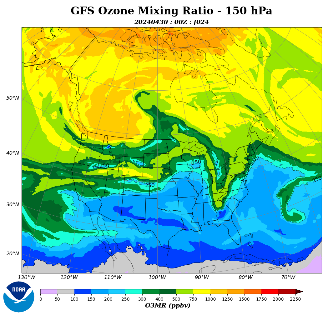
Such a weak polar vortex will cause strong jetstream meanders.
A strong wave from the stratosphere will hit in three days in the northwest of the US.
The polar vortex forecast in the central stratosphere is unusual. Such weakening of the polar vortex at the beginning of winter has not been recorded in recent years.


https://earth.nullschool.net/?fbclid=IwAR2MPQfVRpyONG_GremHGS0pfMnpgsuF6X50n8lx5mXFYxs9RbdJASJHT7I#2019/11/26/0000Z/wind/isobaric/10hPa/orthographic=-351.45,86.78,340
The distribution of ozone in the north during a weak solar wind depends on the changing magnetic field.
Your scenario is very doubtful. If you read the paleoclimatology text books, during the last temperatures before today’s (during the Holocene Climate Optimum), the Intertropical Convergence Zone moved north, carrying the Monsoons with it. This is what turned the Sahara from a desert into a well watered plain the size of the United States.
These things cannot be considered in isolation from each other.
“Over the past few years, it has become apparent that at high altitudes, the Earth’s tropical regions are heating up more quickly than the rest of the world. At least partly because of this, the tropical regions of the atmosphere have been widening, expanding ever so slightly away from the equator, and impinging more on the jet stream.”
Actually, some of the computer climate models have predicted a warming of high-altitude air over the tropics, but the actual data have shown cooling of those areas. It seems like Prof. Woollings is spouting the typical AGW propaganda and predictions, rather than using actual data.
It has long been known that the meandering of the jet stream increases with low solar activity, and decreases with high solar activity. Only in the last few years have the usual suspects have tried to blame it on climate change.
As I show in my most recent paper, when it comes to the purported CO2-induced climate change™ no one knows what they’re talking about.
Not the IPCC, not Tim Woollings, Associate Professor in Physical Climate Science, Oxford University, and not anyone else who relies on climate models to predict the climate.
Maybe the NH jet is thrashing about more violently than before. But no one, and I mean no one, can assign any such change to the effects of human CO2 emissions.
The whole of consensus climatology — all of it — lives on false precision. It’s a crock all the way down.
I am concerned. I predicted solar-driven global cooling to start about now in an article published in 2002, and tried to warn the British government about their dangerous climate-and-energy policies in a letter to the Stern Commission written in 2005 and an open letter written in 2013 to The Parliamentary Under-Secretary of State, Department of Energy and Climate Change, Baroness Verma, excerpted below:
https://wattsupwiththat.com/2013/10/31/blind-faith-in-climate-models/#comment-1130954
[excerpt]
So here is my real concern:
IF the Sun does indeed drive temperature, as I suspect, Baroness Verma, then you and your colleagues on both sides of the House may have brewed the perfect storm.
You are claiming that global cooling will NOT happen, AND you have crippled your energy systems with excessive reliance on ineffective grid-connected “green energy” schemes.
I suggest that global cooling probably WILL happen within the next decade or sooner, and Britain will get colder.
I also suggest that the IPCC and the Met Office have NO track record of successful prediction (or “projection”) of global temperature and thus have no scientific credibility.
I suggest that Winter deaths will increase in the UK as cooling progresses.
I suggest that Excess Winter Mortality, the British rate of which is about double the rate in the Scandinavian countries, should provide an estimate of this unfolding tragedy.
As always in these matters, I hope to be wrong. These are not numbers, they are real people, who “loved and were loved”.
Best regards to all, Allan MacRae
“Turning and tuning in the widening gyre, the falcon cannot hear the falconer…” Yeats
The animation below shows the current impact of the polar vortex on the jet stream over North America.
The coldest air comes from the intrusion of stratospheric. It is very dry and contains a lot of ozone. These properties can increase the risk of California fires.
http://tropic.ssec.wisc.edu/real-time/mtpw2/webAnims/tpw_nrl_colors/namer/mimictpw_namer_latest.gif
It started snowing this morning here in the coastal mountains of Northern California. This is finally ending the seasonal fire danger, and a very late season it was. The snow also means that temps are a bit warmer at night, but when the clouds clear tomorrow then temps are set to drop to record lows by Thursday. The forecast is for temps of 10 to 12 degrees F. My unit sits in a natural cold spot so I get around 4 degrees colder than that. Going to get cold around here.
Hubert Lamb, the man who started the UKCRU, predicted that a wandering jetstream would be a feature of a cooling Planet and by it’s nature bring extreme weather to areas of the planet within the temperate zone.
He also predicted the takeover of his unit by environmental nutjobs who would blame everything on humans.
The height of tropopause drops very much during stratospheric intrusion. This is the height of the convection.


Just to be clear (and ornery), the easily predictable LONG term climate outlook is extremely cold due to the Second Law of Thermodynamics. Jus’ sayin’ . . .
“Weather worries
The jet has always varied – and has always affected our weather patterns. But now climate change is affecting our weather too.”
___________________________
Nonsense.
– The jet stream is 1 component of: weather.
– With or without climate change weather is: weather.
– What will you affect here – weather is the sum of atmospheric affects that we call: weather.
“the planet-heating greenhouse gases we’ve added to our atmosphere mean that invasions of polar air these days are just that bit milder.”
___________________________
Please xplain how “planet-heating greenhouse gases”
produce energy to heat planet + atmosphere incl. “planet-heating greenhouse gases”.
In case that “planet-heating greenhouse gases”
produce enough energy to heat planet + atmosphere incl. “planet-heating greenhouse gases”
by burning “planet-heating greenhouse gases”
: Your problems are solved – “planet-heating greenhouse gases” burn themselves to heat
planet + atmosphere incl. “planet-heating greenhouse gases”.
___________________________
What you luke warmers never ask: who created the creator –
You’re the new “proof of the existence of God” generators. Retarding to medivial religion wars.
https://www.google.com/search?q=religion+wars+proof+of+the+existence+of+God&oq=religion+wars+proof+of+the+existence+of+God&aqs=chrome.