Watching the current maps and models, it appears the 2019 Atlantic Hurricane Season is off to a slow start. For people that the depend on disaster porn (climate alarmists, media) that means no weather events to claim as being climate driven.

With no current areas of storm development, 2019 has had the slowest start since at least 2004 when Hurricane Charley was named on August 9th, 2004.
In a private email with top-notch hurricane forecaster Joe Bastardi, he concurs with that assessment and adds:
“…there is a chance that this could tie 1977 for lowest August ACE.”
ACE= Accumulated Cyclone Energy, an index used to measure TS/Hurr energy released into the atmosphere. 1977 had the lowest season for ACE.
NHC says nothing is likely ahead in the next 5 days:
Tropical Weather Outlook
NWS National Hurricane Center Miami FL
800 AM EDT Wed Aug 7 2019

For the North Atlantic...Caribbean Sea and the Gulf of Mexico:

Tropical cyclone formation is not expected during the next 5 days.

$$
Forecaster Stewart

Assuming no new tropical cyclones form by August 9th, the slow start of named storms would then go back to 2001 when the Tropical Storm Chantal was named on the 14th of August.
The peak of the season lies ahead in September.

I get mail— From the Sigma Xi President: A Call to Action August 05, 2019
“ Each day brings news of how our climate and our environment are historically changing, and research shows that human activities and population growth are the leading factors. With these changes comes an urgency to find solutions to ameliorate the impact of the rising temperatures that are causing extreme weather events, rising sea levels, and the alteration of plant and animal habitats. ” Urged to attend upcoming conference —“Our Changing Global Environment: Scientists and Engineers Designing Solutions for the Future,” which concludes “.. with the first ever Sigma Xi STEM Art and Film Festival, which explores science through visual arts.”
I guess the Sigma Xi President was raised on “Blowing Away in the Storm” of instead of “Singing in the Rain.” It is the 50th anniversary of Woodstock.
Could slow start mean energy building for big one ?
I was going to say the same thing… as parody.
I suspect others will give you a better and more thorough explanation, but just in case I’ll give you my take. The energy that creates hurricanes comes from the latent heat of water off the western coast of Africa. The waters are cooler than normal. Moreover, energy can stop storms from developing. Strong upper level winds blowing from the west can disrupt a storm from growing. This is called wind shear, and it has been happening this season.
So, in a nutshell, the energy needed to form a hurricane has been largely absent, and the energy that is in the atmosphere has been hindering their formation.
There is no energy ‘building up’.
technical technical technical… Barry was real people… July 13th, 2019.
Hurricane Barry was theoretical.
OK. But technical is real too.
Barry formed in that well known hurricane nursery of Kansas.
https://en.wikipedia.org/wiki/Hurricane_Barry_(2019)#Meteorological_history
The storm formally know as Barry, is now formally called Barely in my book 😉
I have never watched a storm get an upgrade post landfall. The NHC change how they categorize storms back in the mid 2000’s and now only a small area has to have extrapolated wind speeds, from flight levels, to qualify.
Courtesy of crankyweatherguy.
https://mobile.twitter.com/crankywxguy/status/1150618858627227654
https://pbs.twimg.com/media/D_fRv3sWwAEtc3h?format=jpg
How convenient for them. Change the definition to achieve the desired result.
The data for every year after the change should have a huge asterisk stating that the numbers cannot be compared to similar numbers prior to the change.
“…that means no weather events to claim as being climate driven.”
But, that hasn’t stopped the deluge of MSM articles blaming warming for increased methyl mercury in fish, first time ever ice-free areas in the Arctic, 30,000 more deaths yearly in urban China from half-a-degree warming, “unprecedented” wildfires in Greenland, and extreme water scarcity in New Mexico, to name just the most recent absurdities.
We still have Aug, Sept, Nov, and October !!!
Nothing in the forsight until 17th, as long as it goes.
Meanwhile at the other end
“Alaska records warmest month ever in July with coastline barren of sea ice
Average temperature for month amid Arctic heatwave was 58.1F (14.5C), nearly 1F above previous high set in July 2004”
https://www.theguardian.com/us-news/2019/aug/08/alaska-warmest-month-ever-july-2019-sea-ice
Circulation of the atmosphere ensures the absence of hurricanes in the eastern Atlantic.
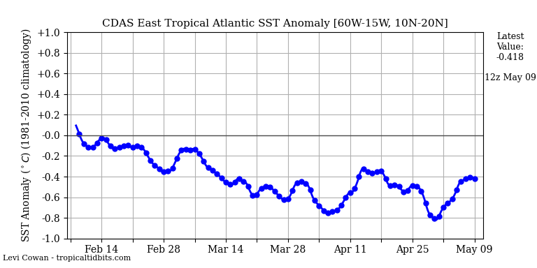
In the Western Atlantic, tropical storms can form in the Caribbean.
https://www.tropicaltidbits.com/sat/satlooper.php?region=watl&product=wv-mid
I was gonna make a smart remark about St Greta’s sea-trip, but several have beaten me to it!
My metrics have this as the slowest start since 2014. The “C” storm that year formed on August 23.
New headline:
Slowest Start to Hurricane Scare Story Season in the History of the Climate Media Crusades
This must be fake news. “Everybody knows” that weather, climate, storm frequency and severity, iron-poor blood, chronic fatigue syndrome, insect plagues, insect extinctions, and all things awful are getting worse on a daily basis, it’s all our fault, and there’s no hope of escape. What if there’s another lull in North Atlantic hurricanes like the 11 years following Katrina? Doomsayers will have to conjure up another apocalypse. Yikes!
It’s so much easier to repeat the mantra, “Everything’s bad and getting worse. 12 years until doomsday. Flog the fossil fuel companies, or it’s over the cliff for all of us.”
Hi Allan
Please pass on this link to my radio interview with Tom Harris
Best, Madhav
http://thinkradio.ca/index.php/our-shows/exploratory-journeys-with-tom-harris/93-exploratory-journeys-episode-007
And just like that NOAA doubles down on stupid….
https://www.wral.com/noaa-now-predicts-above-normal-atlantic-hurricane-season/18557731/
https://www.googlesciencefair.com/projects/2018/171e50b2cff5898513e14907f2c63bbebafcd1827c2fb5bc575f3f1c0950a1b3– Th future looks bright
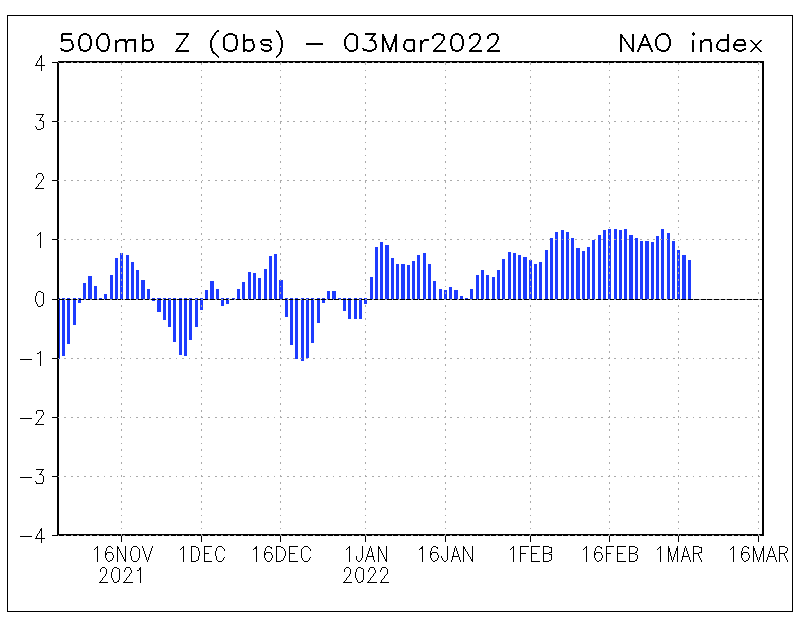
This pressure distribution in the North Atlantic is not favorable for hurricane development.
I realize this story is a few days old and has dropped off everyone’s radar, but I’m really curious. Could the dearth of energy coming off the west coast of Africa be related to the European heat wave(s)? It seems like the warm air that normally crosses the continent and hits the Atlantic was funneled northward instead. Is this a known phenomenon?
The heatwave was a weather event set up by the positioning of high and low pressure areas in combination with a certain jetstream configuration. Research ‘omega block’ for an explanation. That situation lasted less than a week, and the various elements have all changed.
The fact that is has a name shows that it occasionally happens. It was random chance that it all came together in the middle of summer, and funneled hot, African air into Europe. Any other time, any other place, and it would likely have been an unremarkable event.
Ay any rate, it is long gone and not affecting low pressure areas coming off the west coast of Africa.
Thank you jtom. That’s what I was looking for.