by Roy W. Spencer, Ph. D.
Chicago may see half a foot of new snow. Storm may delay spring planting.
A near-repeat of March’s “bomb cyclone” will bring up to 30 inches of snow this week to portions of Minnesota and South Dakota, with blizzard conditions and a threat of severe thunderstorms.
Roughly the same area that experienced flooding rains in March — and still trying to dry out enough to plant corn and soybeans — will see another round of heavy rain and heavy snow. The forecast location of the intense cyclone as of Thursday morning April 11 shows it taking a similar path to the record-setting March storm:

Forecast locations of strong low pressure and precipitation patterns Thursday morning, April 11, 2019 (Weatherstreet.com).
Forecast snowfall totals by midday Friday April 12 indicate the heaviest snowfall (up to 30 inches) over southern Minnesota, with 12-16 inches for Minneapolis:

Forecast total snowfall from the GFS model by midday Friday April 12 (graphic courtesy of Weatherbell.com).
The European ECMWF forecast model adds similarly heavy (~30 inches) snow totals in eastern South Dakota. Much of Wisconsin and northern Michigan are forecast to receive 6 to 12 inches.
The energy for such intense cyclones comes from the strong temperature contrast between two air masses. For example, by late Wednesday the temperatures in Nebraska will range from the 70s in the southeast to the 20s in the northwest, simultaneously feeding both blizzard conditions and a severe thunderstorm threat within the state.
The climate refugees waiting to move to Duluth will need to delay their move now. How disappointing!
https://www.duluthnewstribune.com/news/science-and-nature/4587779-duluth-destination-climate-refugees
That’s hilarious. Poor Keenan! (what a maroon…)
The new Duluth climate refugees will need to add the phrase “bomb cyclone” to their vocabularies.
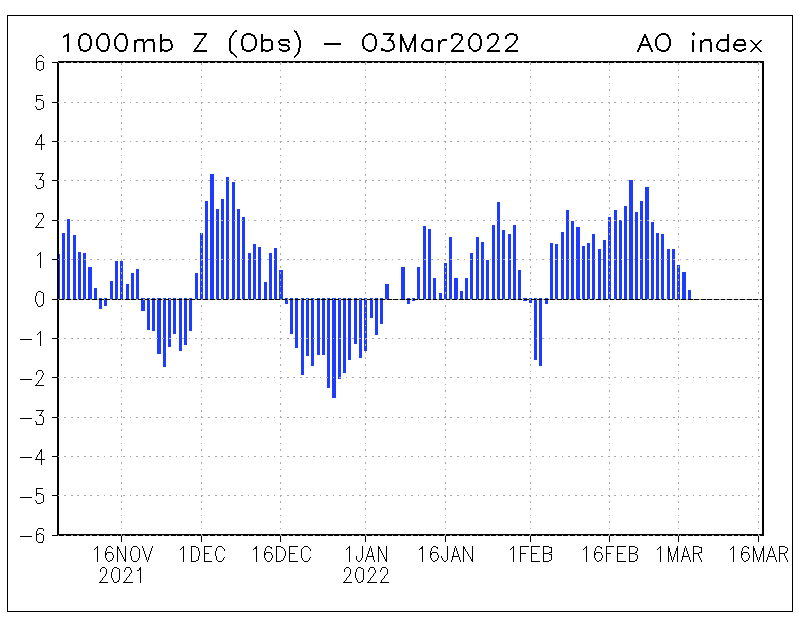
The daily AO index
The pressure over Iceland increases to almost 1040 hPa.
Thunderstorms cause flooding on the Mississippi.
http://www.lightningwizard.com/maps/North_America/gfs_cape_usa60.png
Wind and precip. wise, this one will be worse than the March storm.
And now that every weather event is attributable to CC, the ignorant media will pile on this with an equally ignorant quote from Mann or his ilk.
we still have left over snow from winter her in SW WI, in the woods on north facing slopes. All of our flooding has been due to a ridiculously frozen ground and large snow load.
Gee whiz, it snowed here in April last year and the year before that and the year before that and the year before that, and so on and so on, and so WHAT????????????
I have pictures. If it snows here at all, I’ll get more pictures. Then I’ll go on about my business.
Having lived in western South Dakota for 13 years, looking at the forecasts, that is setting up to be a standard spring blizzard. What is all this “cyclone bomb” hooey?
Kinda curious,what were the conditions leading up to the 1926 -1927 Mississippi flood?
Low it will follow the stratospheric intrusion.

Meanwhile the arctic sea ice extent is at ‘lowest for date’ for satellite record for tenth day in a row, following a period of warmer than average over arctic ocean.
which is undoubtedly related to this and undoubtedly due to climate change.
The stratosphere shows something else.
Ah, yes, arctic ice returning to where it was in the 40’s. Call me when it gets as low as the thirties, when CO2 was really high – not! Air temps have been low this past 3 months, compared to recent years, and still way belie freezing. It’s bottom melt, not air temps that effect the ice now. Get your facts straight Griff, it’s embarrasing.
“Ah, yes, arctic ice returning to where it was in the 40’s”
Really?
I’d be interested to see evidence of that, as in a peer-reviewed paper.
Do you have any?
And sea ice volume is way up:
http://www.cpom.ucl.ac.uk/csopr/seaice.html
Certainly the largest in the satellite record (though that only means since 2010)
Meh…
The Danish Meteorological Institute shows the arctic sea ice extent is fine:
http://ocean.dmi.dk/arctic/plots/icecover/icecover_current_new.png
Don’t trust Mark Serreze’s NSIDC. They’re still trying to show the arctic is screaming.
griff, you report that arctic ice extent is at “lowest for date”.
But as we both know Arctic ice extent from February 21 to March 21 was the highest it has been in the last five year. Undoubtedly due to weather staying about the same, not global warming/aka climate change.
80 today (tues), 4″ snow predicted for thursday. Just another April