- Polar vortex is an atmospheric circulation pattern that sits high above the poles
- Warm air moving into the Arctic can cause it to weaken and split into vortices
- These can bring colder temperatures and extreme weather to mid-latitudes
- Experts say split at the end of this month could cause severe weather in US
- The effects would likely come later in January and early February, experts say
By Cheyenne Macdonald For Dailymail.com
Published: 13:34 EST, 28 December 2018 | Updated: 14:25 EST, 28 December 2018
The Eastern United States could be in for a blast of frigid weather.
Activity in an Arctic climate pattern could send the polar vortex barreling towards more southern latitudes to envelop parts of North America, Europe, and Asia.
The phenomenon has led to extreme winter weather in recent years, including record low temperatures in the US back in 2014 and last year’s ‘Beast from the East’ in the UK.
While there’s still time for things to change, the models currently suggest a split in the high-altitude polar vortex will ring in the New Year, creating the potential for ‘more severe winter weather’ in the Eastern US in the weeks to follow.

The Eastern US could be in for a blast of frigid weather. Activity in an Arctic climate pattern could send the polar vortex barreling towards more southern latitudes to envelop parts of North America, Europe, and Asia. The illustration shows how a polar vortex reaches the US
The latest predictions come from Dr Judah Cohen, of Atmospheric and Environmental Research (AER), and are supported by models from several other researchers shared in the last few weeks.
The polar vortex is an atmospheric circulation pattern that sits high above the poles, in a layer of the atmosphere called the stratosphere.
This structure can weaken as a result of abnormal warming in the poles, causing it to split off into smaller ‘sister vortices’ that may travel outside of their typical range.
As of the end of December, the models show the polar vortex situated above Scandanavia could break apart to become two or even three vortices, bringing colder weather to the mid-latitudes and warmer weather in the Arctic.
According to Cohen, ‘a stratospheric PV displacement or split is looking more and more likely during the last week of December and into the first week of January.’

As of the end of December, the models show the polar vortex situated above Scandanavia could break apart to become two or even three vortices, bringing colder weather to the mid-latitudes and warmer weather in the Arctic
Video playing bottom right…
Click here to expand to full page
The split higher up in the atmosphere could eventually cause a similar phenomenon to ‘drip’ down to the troposphere – the layer of the atmosphere closest to the surface, where most of our weather takes place.
This process generally takes about two weeks, Cohen explains in a blog post published this week.
A split in the polar vortex can give rise to both sudden and delayed effects, much of which involves declining temperatures and extreme winter weather in the Eastern US along with Northern and Western Europe.
‘A sudden stratospheric warming usually leads to a warm Arctic not only in the stratosphere but also at the surface as well,’ Cohen explains.
‘And a warmer Arctic favors more severe winter weather in the NH midlatitudes including the Eastern US.

While there’s still time for things to change, the models currently suggest a split in the high-altitude polar vortex will ring in the New Year, creating the potential for ‘more severe winter weather’ in the Eastern US in the weeks to follow. File photo
Read the full story here.
HT/Marcus
Discover more from Watts Up With That?
Subscribe to get the latest posts sent to your email.
Dangerous weather in the north of the US. Wind speed in Nebraska exceeds 50 km / h.

NOAA predicted a mild winter because we’re in an El Niño cycle, however, it was very weak and short, and already peaked in mid-October.
ENSO 3.4 SST is currently at .71C, and will likely fall below 0.5C by the end January.
For some reason, NOAA is predicting another El Niño to start towards the end of 2019, which makes no sense, and is likely just wishful thinking.
The next La Niña starting in 2021 should be strong one as they usually occur every 10 years or so, and the last strong one was in 2011.
Moreover, by 2021, the PDO, AMO and NAO should all be in their respective 30-year cool cycles, and a 50-year Grand Solar Minimum will also likely start in the same year. The Blob is also finished, so all these cooling phenomena will lead to decades of global cooling with many nasty and bitterly cold winters, as occurred during the last PDO cool cycle (1945~1977).
CAGW alarmists will be ridiculed in the near future…
” 50-year Grand Solar Minimum ” . . . from 2021 to 2071
I have no idea what that means.
Nor do I have any idea how anyone knows.
If by “The Blob” you mean sea surface temperatures west of B.C. and WA,
it comes and goes with the pressure systems; the term episodic fits.
Don’t expect it to be “finished” for 50 years.
John-san:
Grand Solar Minimums (GSMs) occurs when the Umbral Magnetic Field (UMf) falls blow 2000 Gauss. The UMF is the magnetic field that holds sunspots together.
The Little Ice Age was likely caused by 4 GSMs between 1280~1820: Wolf, Sporer, Maunder and Dalton).
A Grand Solar Maximum (strongest in 11,400 years) occurred from 1933~1996 and accounts for much of 20th-century warming, not CO2…
The Blob was a rare phenomenon, which recently ended.
We’ll see soon enough.
Happy New Year!
The “polar vortex” is actually controlled by the super-top-secret weather machine in the sub-basement of the White House – formerly controlled by evil VP Cheney, it is now personally controlled by Donald Trump, who is still a mere novice at it, and whose whims are unpredictable and chaotic. Each night he sits at the controls, deciding where to release the Magic Molecule to affect his enemies adversely by the invisible rays emanating from the machine, that manipulate, change and move concentrations of CO2 around the globe.
Remember, there is absolutely nothing that “global warming” AKA “climate change” cannot do via the Magic Molecule – and the left has already told us, it’s all Trump’s fault. I am just the first one to explain how it’s actually done, although others have hinted at it beginning several decades ago. The truth must be told!
Nothing “abnormal” about this pattern. It is the normal winter pattern for the Northern Hemisphere. The land losses heat faster than the oceans. Open ocean water is very warm compared to Siberia, Northern Canada, and Greenland. The warmer water, warms the air above it, which bubbles upward because it is less dense than the surrounding air cooled by the colder land.
Add the fact that as you move away from the equator the atmosphere has more shear on it, because the Earth is pulling the atmosphere during rotation. The atmosphere is flowing in a turbulent pattern, which gets anti-zonal when there are temperature gradient variations.
As the sea ice caps the open water, there is less temperature variations between land and ocean, and the Northern Hemisphere settles in for a “long winters night”.
Let us summarize. Allegedly warming of the Artic destablizes the polar vortex. The polar vortex breaks into a series of vortexes. This, in turn, increases the meridional flow which allows warm air to reach the Arctic. The Arctic warms.
Seems faintly like perpetual motion, or perhaps more like a positive feedback, doesn’t it.
Long ago people spoke of a zonal index. I have no idea if the concept is still in use, but people noticed the tendency of the atmospheric flow to fall roughly into two states. A state of predominate zonal flow with large north-south pressure and temperature gradient, versus a state of meridional flow with cut off highs and lows, smaller pressure and temperature gradients, with warm air intruding into high latitudes.
According to models, the warming of the Arctic causes itself. Climate science advances.
Climate science is the application of scientific words with the express purpose of confusing the reader, until his eyes glass over, and he accepts his own weakness in untangling the logical Gordian Knot that is climate science.
The Arctic is not warm in the winter. Saying it is warm or warmer, is where you lose most readers who think something “abnormal” is going on, because they know that it is cold and dark this time of year. But it is usually cold and dark in Siberia as well, and many times it is colder than the Arctic which has the ocean to slowly release heat into the atmosphere.
And air moves. When air moves from A to B, air also moves from “somewhere” to fill in the void where the air that was at B, is no longer there. Most of the “warmer than average” air over the Arctic is due to open water sources, and air moving in from other areas. Where I live, air from the north lowers the high for the day about 10* F. Air from the south raises it about the same, and zonal flow is about average.
If we have a pattern that sets up and delivers an extended flow out of the north, it is not unusual or “abnormal”.
I wonder where the Daily Mail obtained the main figure, showing a “stable” polar vortex and a “wavy” vortex, followed by some wording suggesting (to me at least) that it is “abnormal warming” which is causing these stability problems. It bears a “NOAA” label, but seems more like some journalistic production than a scientific diagram.
Actually (as noted by ATheoK above), the boundary of the “wavy” vortex (aka planetary Rossby waves) is the normal configuration. The so-called “stable” configuation is actually unstable because PV’s arise from an imbalance between pressure gradient forces and Coriolis forces (“geostrophic wind”). There exists a positive feedback from latitude displacement in the sense that the imbalance increases from wind latitude change. So any slight wobble turns into bigger waves.
These Rossby waves have been rolling around the planet for a long time, long before GHE became an issue.
A great snowstorm develops on the Great Lakes.

The map linked to is for temperature in Celsius.
The Great Lakes region is mostly about 40°F south to below freezing north.
Still snow will be hard to find. Scattered flurries seems to be the call.
Maybe next week for a great snowstorm.
You have to wait for a while.

It will be even more interesting, because the stratosphere will receive more energy from the solar wind.
http://www.solen.info/solar/images/AR_CH_20181230.png
“I wonder where the Daily Mail obtained the main figure, showing a “stable” polar vortex and a “wavy” vortex”
It comes from dumb down, blend, baffle and scare.
British tabloids love it, and the BBC even review them with glee and happiness.
They feed off each other, like bottom feeders in a pond.
Being as the British have never ever seen a snow tyre, they have been brow-beaten into believing one snow flake is mortal danger, planes can’t land on it, trains call it “the wrong shape or type” and people keep their kids at home when one falls, you have to sympathise.- with the odd island foibles.
The Tabloids feed on FUD & in winter on frightening people witless with snow or frost.
The predictable result is chaos, which makes the papers lots more money.
People in the UK buy these news papers because it makes them feel warm & comfortable.
When they go home, they can wrap their fish and chips in them.
Cop that, Warmistas!
Bear in mind that forecast is by researchers, not NWS operational forecasters. The official forecast is very different. You can see it here. Time will tell who got it right, but the operational guys are pretty good. Note also how different the official forecasts are compared to the typical alarmist forecast that predicts fractions of a degree change decades into the future.
http://www.cpc.ncep.noaa.gov/products/predictions/90day/
In this oxymoronic world of alarmism the colder it gets from this polar vortex the more this will prove that the world is warming dangerously and unless we stop using fossil fuels and eating meat and transferring money to developing countries we will pass the point of no return in 12 years and the world will become unliveable because the climate has changed and deniers like president Trump deny the reality of global warming( or maybe cooling) .
Sounds like another irrefutable factual truth coming to help the alarmist cause. Go figure!
Isn’t the graphic on the right the normal jet stream and the one on the left…. fantasy?
You are correct. The normal configuration is governed by planetary forces which are manifested by the “wavy” streams, which look like the graphic on the right. The graphic on the left, which the article calls stable”, actually doesn’t happen in nature. If it did, it would only last a few minutes before deteriorating into the wavy version.
Yet the article (sprinkled with the usual alarmist buzzzwords like “severe”, “extreme”, “abnormal” etc) suggests that the fanstasy “stable” version is normal, but happens to be “abnormally” distorted by global warming, pushing warm air up into the Arctic. That’s a complete myth.
‘
Actually, those wavy lines (aka “Rossby waves”have nothing to do with global warming or GH gases, but are created as an artifact of the rotational forces (Coriolis) interacting with atmospheric circulation induced by pressure gradients.
But don’t be alarmed, rotation is a good thing, not bad, because if the Earth didn’t rotate on its axis there wouldn’t be any “weather”, but a just static planet where the sunlit side would be boliing hot and the dark side dry-ice old. We should be thankful that we only have to just have to put up with cyclones, and occasional Alberta clippers and such.
Here is a good resource, which explains how the two kinds of polar vertexes operate (tropospheric and stratospheric) and dispels the myth above, tha the polar vertex is driven by climate change.
https://journals.ametsoc.org/doi/pdf/10.1175/BAMS-D-15-00212.1
“tha the polar vertex is driven by climate change.”
There we go again.
AGAIN:
This article does NOT make that claim.
It is a purely meteorological process.
Where GW does come in is in Arctic amplification, where greater heating in the Arctic vs mid-latitudes reduces DeltaT at jet levels and hence the PJS…. leading to more “waviness”.
There _you_ go again.
The article does make the claim, in the figure captions: “warm air pushes up” “cold air pushes down” making those “stable” streams go all “wavy”. Guess what made the air warm?
Then all that warm air is made even warmer by GA, which even you believes is more GW.
But that’s not what makes those wavy streams in reality (read the reference doc). So I guess it was a myth, needing s thorough debunking, after all.
“Guess what made the air warm?”
The tropical ocean.
As I said, natural meteorologic factors plus some help from the Sun.
Been happening for millenia.
AGW not needed.
https://spaceweatherarchive.com/2018/09/27/the-chill-of-solar-minimum/
It’s the sun stupid. Even nasa has stated that due to lack of solar activity the upper atmosphere has cooled. They have even suggested in another post that due to lack of solar activity the magnetic pull that causes a straightened jet has declined causing the jet stream to curve more than normal.
If the sun cools .. so will earth. Sometimes we get lost in minutia .. we need to to look at the heater up in space!
“Guess what made the air warm?”
The tropical ocean.
As I said, natural meteorologic factors plus some help from the Sun.
Been happening for millenia.
AGW not needed.
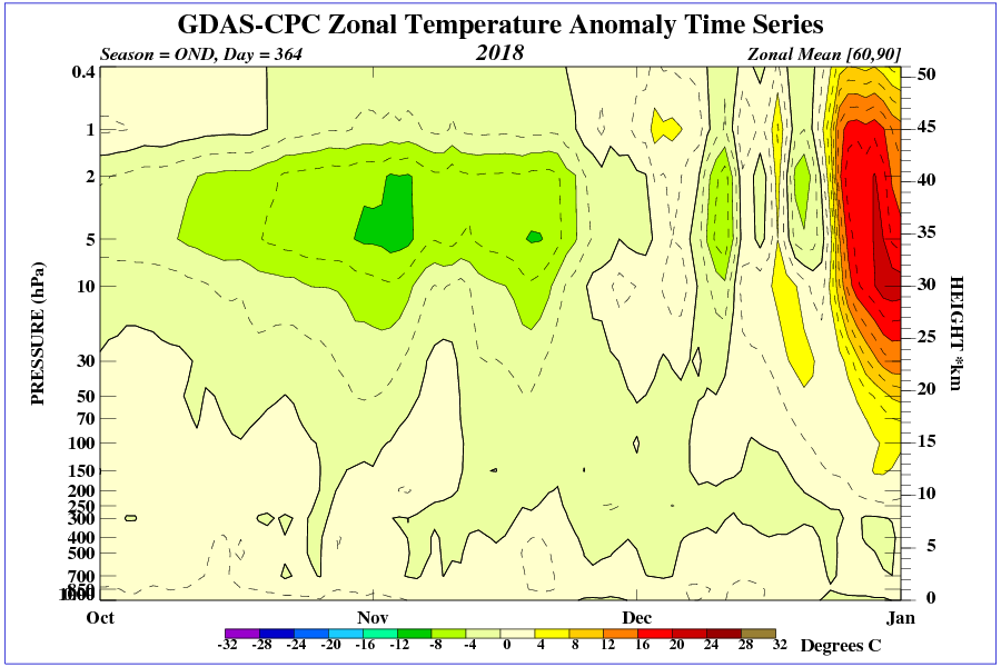
Polar vortex breakdown is transferred to the lower stratosphere.

Anomalies of temperature in the stratosphere over the polar circle.
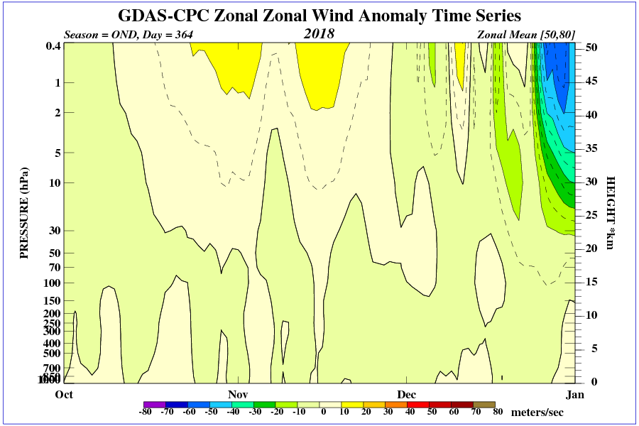
Visible weakness polar vortex (wind) in the upper stratosphere.
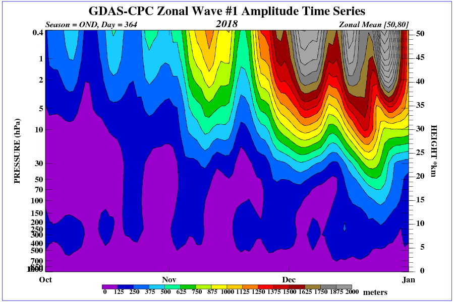
Visible waves in the upper stratosphere that led to the breaking of the polar vortex.
If The Daily Mail said the sky is blue and the grass green I’d go outside to check.
The Daily Mail never knowingly pass-up the opportunity to use over-dramatic prose to report/opine on anything likely to cause alarm.
Global warmers have made me an evil person. I now ENJOY reading about abnormally cold weather out of spite.
Ozone displaces the water vapor in the upper troposphere the western US.

Whenever I read ‘experts say’ my bullsh*t alarm goes nuts
Another could be forecast of something could happen
On January 5, a small polar vortex will separate in the stratosphere over eastern Canada.

Between Greenland and Scandinavia stationary high will be created.
January 3rd here in RI. The forecast has us at or above freezing during the day for the next ten days. The last few years we were looking at sub zero temps this time of the year.