As a frigid, perhaps the coldest on record for many, Thanksgiving approaches for many across the United States, here is an anecdotal tale of a lifetime of weather in Louisiana.~ctm
By Kenneth Bahlinger,
South Louisiana Snows and Winter Weather Events:
You and I want it to snow in the deep south every winter. A year ago if someone would have said that it was going to snow here in Baton Rouge in less than a month from today, we would probably say no way.
However the past 10 years have been an unprecedented period of winter weather for the Deep South especially here in the Baton Rouge area. That includes three measurable snows in early December; Something that had never happened in the previous over 100+ years of record keeping. In fact before 2008 there had hardly been even trace snows in Baton Rouge in December. The below link has records of measurable snow for McComb, Baton Rouge, New Orleans and Biloxi/Gulfport through 2010.
https://www.weather.gov/lix/snowcli
My first memory of snow in Baton Rouge was in first grade, 1968 on February 23. That was also the same year about a month later, March 22 and 23 when we had large white flakes, the latest recorded trace of snow. I remember my teacher catching flakes on black construction paper not knowing that the true hexagon flakes do not fall at 34 degrees. Ever since that snow in first grade in 1968, when we had measurable snow, we were lucky to get 1-2 inches.
In 1973 we had two measureable snow events about a month apart. Though there was trace events almost every year after 1973, it was not until 1988 that Baton Rouge had another measurable snow. In February 1988 it actually snowed twice in three days though the second snow was labeled as a trace event. That second snow on February 7 was the only snow that I remember snow starting out as snow.
The above graph is missing New Year’s night snow of 2002 when we got about an inch. That started around 10:30 pm.
There have been at least 3 times when New Orleans has had measurable snow and Baton Rouge none, including December 31, 1963 (4.5 inches), 1989 Arctic outbreak and Christmas 2004.
December 2008 brought the earliest measurable snow ever on December 11. As incredible as that was, in 2009 it snowed for a second consecutive year even one week earlier, on December 4, an event that dumped the 8+ inches in the Florida parishes, about 40 miles east of the airport. There was a second snow on February 10, 2010; Another twice in a season snow.
2014 brought 4 wintry weather episodes to Baton Rouge. Though it did not snow much, it was just as a memorable winter weather event here in Baton Rouge. Incredible as it was, January 24, 2014 at 2 PM it was 25 degrees with freezing rain and sleet. The moderate rain brought some warmer temps, or it would have been a devastating ice storm. We had about 18 hours of the event. It did begin as moderate snow around 12:30 am before changing to sleet and freezing rain. We were just so close to a record snow fall, expect for the warm layer 8 thousand feet above.
And only 4 days later it was 28 degrees at 2 pm with more of a sleet event storm, about 9 hours of wintry precip.
Then on February 6 we had sleet with a few flakes for a few hours around midday. This would have been a noteworthy event if not for the previous 2. The temps stayed just above freezing, so no accumulation.
And then when thinking about a March 4 Mardi Gras, you would think it would be one of the warmest. Yet at on March 4 temps climbed from the upper 20’s in the morning to 31 degrees at noon with a moderate freezing rain. A few degrees colder or perhaps earlier in the season, it might have been a major icing event. Still this was one of, if not the biggest, freezing rain event I have seen here in Baton Rouge. Even worse than the January 24 event. I have seen other freezing rain events over my past 45 years, but not like this. Freezing rain events are rarer than snow here in Baton Rouge and even hard to obtain in January and February. 2014 was another season of one in your lifetime weather events.
And then the 2017-2018 winter, another 2 event season. Both events are not logged in on the Slidell NWS graph. On December 8, 2017 another early December measurable snow. While I had 3 inches here in Baton Rouge the biggest swath was just to the south around Prairieville with about 6 inches.
The second season event was January 16, 2018. The mostly snow line was just to our north, but we had a good mix. It was 22 degrees and snowing at 9:00 pm; The coldest I have ever seen it snow here in Baton Rouge.
What once in a the lifetime winter events are ahead? Will the wintry weather trend continue?
Maybe, nobody can predict.
rd50 – maybe not predict – how about command the weather?
Apologies to all back east, I was having a really bad day – I had a 30-hour flight the next day from sunny warm Thailand to sunny cold Calgary – I guess I was a bit cranky. So I called down the cold on you Osties – my bad.
https://wattsupwiththat.com/2018/11/17/will-the-snowiest-decade-continue/#comment-2521702
Fair warning:
I’m calling down another very hard winter on the US Northeast, extending up into Canada.
The reason I’m doing this is that you deserve it. You continue to bleat about global warming, in a world that is about to get colder.
You continue to blather on about climate change and the need to eliminate fossil fuels – do that tomorrow and most of you will be dead within a month or two.
Fully 85% of global primary energy is fossil fuels and that number has not changed significantly in decades. Fossil fuel energy provides almost everything you need to survive in this complex world. It IS that simple!
So enjoy the bitter cold and snow this winter, good people, and maybe you will actually learn something.
Cold kills far more people then heat in the world today, probably about 2 million excess winter deaths per year.
Bundle up!
Post Script:
Looks like I did this once before – in January 2016. My bad too.
https://wattsupwiththat.com/2016/01/22/friday-funny-probable-cause/#comment-1696813
OK – enough!
I’ve had it with you Eastern warmists.
So in February, I’m calling down some brutally frigid winter weather on you.
Mark you calendars and get out your long woollies…
You see? It’s working!
Cue Twilight Zone music…
https://weather.com/maps/ustemperaturemap
I suppose I have to say “sarc/off”. 🙂
….and it’s only November
Message received, Allen. It is presently -15 C at 4:30 AM and still dropping.
Thanks for the gas. It’s lovely.
Methane – beautiful energy – it’s a gas. 🙂
It’s tough to make predictions, especially about the future.
Yogi wrote:
“It’s tough to make predictions, especially about the future.”
Actually, I’m doing pretty well. Apologies to all you frozen people. My bad.
https://weather.com/maps/ustemperaturemap
No doubt Michael Mann will say “exactly what the models predicted”
Really. You care about his predictions?
Why do you care about him?
Hi rd,
I guess it matters because “predictions” from such individuals have real-world implications at the national and even global policy level. Is that fair of me?.
Therefore, such people should always be called out for their proclamations.
Anyway, I’m sure this will be put down to “regional weather only” etc….
Early 60’s, about 62-66 timeframe in Huntsville, AL and Atlanta, GA had a number of snowfall winters and number of freeze snaps when I lived there.
https://grist.org/article/sorry-winter-storm-jonas-doesnt-make-climate-change-a-liberal-hoax/
MICHAEL MANN SAID MAN MADE GLOBAL WARMING WILL CAUSE MORE SNOWSTORMS BECAUSE THERE WILL BE MORE WATER VAPOUR IN THE ATMOSPHERE. This presumes 3 things
1) CAGW is real . If only AGW was real, then adaptation solves everything
2) Water vapour travels to cold areas from the now hotter areas
3) The colder areas are not affected as much by global warming
No 1 is simply false
No. 2 While clouds do certainly travel; and air masses that include water vapour do travel in the atmosphere, there is no complete algorithm or formula that will determine this. There are regular cyclical air movements like the Hadley cell …etc. but these have always been around before 1950. The 2 reasons why water vapour gets in the atmosphere in the 1st place are evaporation and low pressure system evaporation. To presume that there will be more water vapour that will then cause more winter storms is to say that global warming will affect an increase in air currents.
No. 3 Climate scientists have as yet to provide an explanation of this
In any case if Mann is correct then we have another measurement to catch him in his fraud. Has there been an increase in the last 50 years in winter storms? Don’t forget that 18 years ago all the climate scientists were saying that we would witness the disappearance of snow.
“ThinkProgress spoke to Michael Mann, the nation’s preeminent climatologist, about Winter Storm Jonas, which was blanketing the eastern seaboard in feet of snow. He said this is not a fluke. “There is peer-reviewed science that now suggests that climate change will lead to more of these intense, blizzard-producing nor’easters,” according to Mann. This is because a warming climate means increased moisture in the atmosphere, and when cold air meets moisture — surprise! — it snows. Sometimes a lot, like we’re seeing right now.”
So what does the last 50 years tell us?
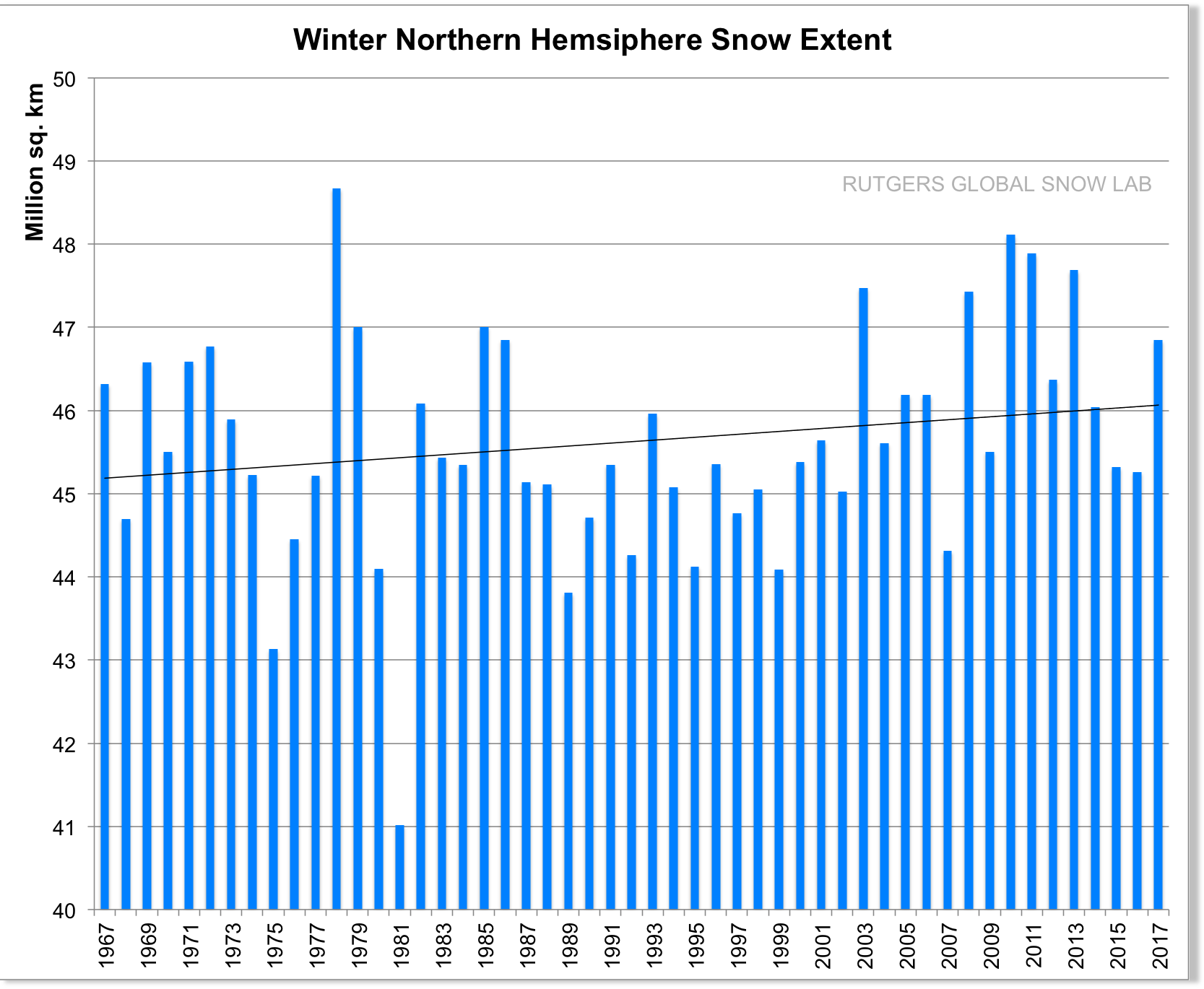
Well, the Northern hemisphere snow extent increase suspiciously looks like the small increase in global temperatures even though
Roger Pielke (the world’s expert on extreme weather events) will certainly confirm that there isn’t any more winter storms than there ever were. So perhaps just as important as temperature charts; the snow extent charts should be regularly looked at. Maybe the climate science should be called Global Storming .
Don’t forget that CO2 is only increasing overall as a trend therefore global warming has to a positive trend. You cannot blame decreasing snow on global warming and then turn around and say that actually global warming causes an increase in snow and then 5 years from now say that global warming will cause a decrease in snow. You cannot have a positive trending variable be the cause of another variable that is cyclical in nature as snowfalls are. The alarmists should just give the snowfall meme up and concentrate on the warming aspects of CO2. At least on that argument their hypothesis is on less shaky ground. Still extremely shaky but less than the snow argument.
“What do the last 50 years tell us?”
Liars gonna lie – Idiots gonna believe
It’s silly to try to catch the warmunists in any inconsistency in their propaganda. They depend on the peer-reviewed, proven fact that 97% of the population is dumber than a box of rocks. The general population are going to believe any and every lie that Mann & Co decide to dish out.
So my fellow ‘Murcans, heed my advice, enjoy your turkey dinner and don’t bother antagonizing your wacky nephew or cousin. Watch a football game, don’t mention Trump.
You Canadians have a nice day too. Maybe come and visit us in America some time 🙂
If you lived on the Southwest deserts you would know that we are already up to our elbows in Canadians and Americans from northern tier states. Fargo, ND, had a couple of days were the high temp was singles digits in the last 7 days.
We call them politely winter visitors. They are also called snow birds and some of the BLM land in our area has RV camping sites for them. We call those snow bird nesting areas.
In the south there was a difference between Yankees and damn Yankees. Yankees were the ones who came to visit and left, damn Yankees were ones the came and didn’t leave. Florida sure looks good in the winter. Well, why not stay…. “I have my pension and costs are a lot less than NY. “
“I’m dreaming of a white Christmas…..”
Dreaming YES. I want a white Christmas. I had many in the past.
Nobody can predict.
Will we have one this year? Nobody can predict. I would like one and I hope you do get one also.
rd50
I lived in Scotland from 1966 to 1988. I never saw a white Christmas.
I have lived in Dickensian SE England from 1988 to date. I have not seen a white Christmas.
Nor do I expect to.
Nor have the weather patterns changed appreciably, we can expect unpredictable snow falls between January and early March but they are light by any standards and temperatures infrequently head down to -5C or so.
Not much change at all over 52 years or so.
But in the 70’s we were warned to expect a new ice age. It didn’t appear either.
I’ve lived in E.Anglia since 1956 and I can remember white Christmasses in my childhood as being something to hope for but not to rely on. In fact I used to pray for them and one year I got my face rubbed in the snow because my big brother held me responsible for the Boxing Day hunt being cancelled! I also have photos of a snowy Boxing Day meet in the 70s.
Susan
No racist remarks here (:-))
SNOW!
https://youtu.be/CH2KGboA35c
Stratospheric polar vortex over eastern Canada.


Very rapid increase in the ice extent on Hudson Bay.
http://masie_web.apps.nsidc.org/pub/DATASETS/NOAA/G02186/plots/4km/r10_Hudson_Bay_ts_4km.png
When winter begins in the US?
??
December 21st, officially.
The temperature in New York has dropped to -7 degrees C.

I’ve always had a problem with that. Dec 21st is the winter solstice. That should mark the middle of winter.
john – November 22, 2018 at 6:04 am
But, but, but, …… that would mean that the “winter solstice” would mark the middle of summer in Australia and other points south of the equator. 😊 😊
john,
Please search with this:
Astronomical vs. Meteorological Seasons
If you look at weather/climate data, you will see it reported with 3 months, such as DJF, MAM etc.
DJF = Dec/Jan/Feb
If you live in Northern Minnesota or North Dakota winter runs from November through March. And it can snow from late September to early May.
Dec. 1 meteorologically. Dec. 21 otherwise.
If you look at temperature normals, minimum temperature is about 5 weeks after the winter solstice, so the solstice is a reasonable start to winter that is easy to recognize.
As the days begin to lengthen, the cold begins to strengthen. brrrr…..
Just to keep it clear:
In the Northern Hemisphere the sun hours begin to lengthen after the December Solstice.
In the Northern Hemisphere the sun hours begin to shorten after the June Solstice.
More or less. It is complicated because of Earth’s motions.
Ever seen an Aussie summer, stinking hot, dry, bush fires and flies? Well, we got snow falls this week too.
James: WTHeck?
Do tell. Is that unusual?
not unheard of but NOT usual by a long shot!
we finally had a few warm days(seeds started to sprout) now its damned cold and likely to remain so for another 5+days they reckon, Vic highlands to 1300ft were warned of snow again today.
SE vic presently is 8c and with sth windchill it feels like 5 or less outside.
There is a terrible storm raging over water between Labrador and Greenland.
https://www.windy.com/?61.559,-57.554,5,i:pressure
Central pressure 955 mb. That is only slightly higher than Sandy the wanna-be super storm.
We got off light last night: minus 13 and the wind dropped.
Unusual but not unheard of. We were shooting in western Victoria 10 years ago in November and there was snow on the sheeps’ backs. Seems every few years there is a cold front event in November, intense lows moving across the south of the continent accompanied by very strong winds which yesterday reduced Sydney airport to a cipher and stranded people round the nation. We don’t cope very well with cold weather in Oz, we’re much better when it’s hot. And it normally gets what we call hot in late December thru to late March.
-16 deg F forecast in upstate New York over the next two days.
Minus -9 deg F forecast in Manhattan, two days running.
That should have read degrees C, not degrees F.
The latest ECMWF model run just arrived and its now saying -20C min tomorrow.
https://on.windy.com/20i5i
Toasty.
Front page image shows undated snowfall in Jerusalem. Perhaps my geoggers is a tad rusty, but not sure that’s in the same neck of the whatsit as Red Stick
Excellent observation Mr. Forbes-Laird. I see that a lot on the internet. It ranges from the misleading to the fraudulent.
All systems normal folks.
It’s cold somewhere,
It’s hot somewhere,
It’s windy somewhere,
It’s calm somewhere,
It’s raining somewhere (Scotland ~sigh~),
It’s snowing somewhere,
It’s flooding somewhere,
It’s drought somewhere,
There’s a hurricane somewhere,
There’s a typhoon somewhere.
Try plugging just those variables into a computer and have it make sense of them. Utterly impossible. The only predictable ‘variant’ is that it’s raining, in Scotland.
Actually it’s far from normal … RECORD SNOW & RAIN …
Atmospheric compression events occurring in all corners of the Earth … see here https://www.youtube.com/watch?v=wop5kFo4eF8&feature=share
Corners! Good one!
Now stop it.
https://theconversation.com/flat-earthers-vs-climate-change-sceptics-why-conspiracy-theorists-keep-contradicting-each-other-96060
“The only predictable ‘variant’ is that it’s raining, in Scotland.”
And Bergen. I was once there and it was sunny – unfortunately I lost the pictures so I can’t prove it!
Does it always rain here, boy?
-I don’t know, I’m five years old!
“My first memory of snow in Baton Rouge was in first grade, 1968 on February 23.”
Apart from the education we received it’s why so many senior citizenss are skeptics of this morphing doomsday theory. Their latest with extreme weather simply doesn’t cut much ice with lived experience.
I heard a TV meteorologist say earlier this week that Mpls / St Paul is experiencing the 23rd coldest November in a 150 years.
The temperature in the state of New York has dropped to -19 degrees C.
A month before astronomical winter.
Remind me, is New York state still planning to completely ban fossil fuels?
/schadenfreude
Here in New Hampshire, we’re having a white Thanksgiving, with wind chills below zero F. Pretty insane. Must be “climate chaos” I guess.
Here in central Wyoming, it’s going on 50 degrees—with high winds, of course (two weather fronts going through). Forecast to snow some on Saturday, but we really have not had much snow on the “flatlands”. The mountains are getting much snow with winter weather warnings for this week.
This is called stratospheric intrusion.

http://www.cpc.ncep.noaa.gov/products/stratosphere/strat_int/
Or just New England being contrarian New England.
The range of ice and snow in Canada indicates a severe winter that starts in 8 days.

There is snow on the cross-State passes in Washington State.**
Chinook Pass, east of Mt. Rainier has been closed — until spring.
Apple Cup Friday, Nov. 23. A football game between UW & WSU.
Remember, folks, unusual warmth is always evidence for Global Warming, unusual cold is merely weather.
Here in my part of the world ( N Lincs, England) we have had a 4 season run of early first snow.
With 15/16 (21st Nov) 16/17 (18th Nov) 17/18 (29th Nov) 18/19 (27th Oct).
Which has lead to a trend of earlier first snows since 1977. lts with interest that during this time the 3 times it has snowed in October, they have all been during the present century with the years been 2000, 2012, and 2018.
This tread is backed by the 50th year NH rising trend of autumn snow extent.
I cannot seem to find the link, but NWS Lake Charles used to have a great page detailing the huge snow event from Brownsville to New Orleans in 1895. On the order of 2 feet of snow in Beaumont, a foot in Baton Rouge, and 8 inches in New Orleans. This one event is always listed as 4 times the amount of snow as second place in the records for any of these sites. That had to be interesting.
I recall the 2004 Boxing Day (Dec 26) snow in New Orleans as I was half way through a year long RV trip round Canada and the USA. We actually stayed at Abita Springs just east of NO on Xmas night and woke to snow and ice. That wasn’t expected in snowbird territory I can tell you. Spent the day in the recreation block keeping warm and chatting to other not so happy campers ! Dog liked the snow though as we don’t see a lot on the South coast of the UK where I usually live.
I remember the freeways round New Orleans being closed as they don’t have gritters etc there.
the other sad reason for remembering that day is because it was the day of the huge Tsunami that devastated S.E. Asia.’
In some parts of the world an El Nino event brings warmth amongst other things. For New Zealand not so much. It is not unusual to see late spring snowfalls in the mountains of the North Island, even well into the start of our austral summer (mid January). It happened again this week in the bottom half of the N.I. while the lower half of the South Island had a very winter-like snowfall. One mountain range at the top of the S.I. had it’s heaviest snowfall of the year a few days ago!
Meanwhile NIWA are struggling to predict what will happen in the coming fortnight, but we are still expected to trust them on what will happen in decades to come right up to 2100! Yeah right
Current temperature and high pressure in the northeast of the US.

Your guys’ PR is TERRIBLE. You have a photo of snow covered palm trees and you don’t put it in the article. Yet hundreds if not thousands of people would have posted the story had they had the palm trees to post. Think of the battle we’re fighting. Make sure you leverage the good images to help us fight.
Sheesh.
Still high pressure in the northeast of the US.
